
Japanese World War II map of Australia.
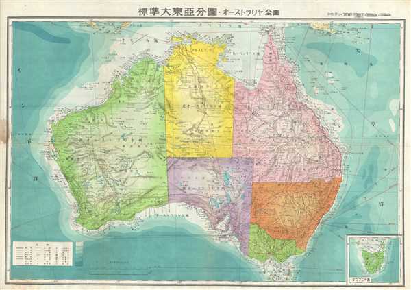
Australia.
sold
- Digital Map Information
- Suitable for large format printing
- File Size: 19.24 MB
- File Type: ZIP / TIFF
- ICC color profile embedded
- Delivered instantly via download link
This is an attractive Japanese map of Australia dating to World War II. Issued in 1943, the map covers the entirety of the continent with color-coding according to state. Offers superb detail regarding both topographical and political elements. Notes cities, roads, ... (more details)
World War II era map of India.
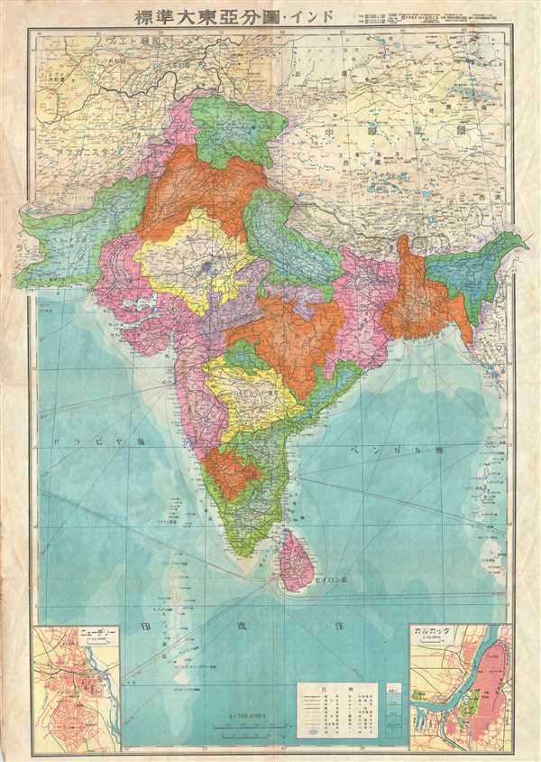
India.
sold
- Digital Map Information
- Suitable for large format printing
- File Size: 22.22 MB
- File Type: ZIP / TIFF
- ICC color profile embedded
- Delivered instantly via download link
This is a beautiful 1943 or Showa 18 large format map of India, issued by the Japanese during World War II. It covers all of India and Pakistan in great detail, and includes Sri Lanka. The map offers superb detail regarding topographic and political features and ... (more details)
Outdoor Life Fish and Game Map of California with Gun Advertisments.

[California].
sold
- Digital Map Information
- Suitable for large format printing
- Full resolution TIFF file
- ICC color profile embedded
- Delivered instantly via download link
This is an unusual c.1921 fish and game map of California by the Wood-Jackson Arms Co. of Long Beach, California. The map features the state of California in its entirety with fish and game areas highlighted in red. The map focuses on trout streams and hunting ... (more details)
Early map showing a distorted Lake Michigan and the site of the Black Hawk War.
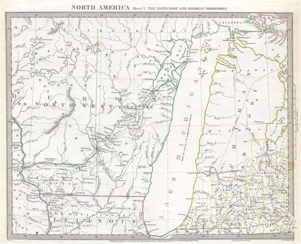
North America Sheet V The North West and Michigan Territories.
sold
- Digital Map Information
- Suitable for large format printing
- DPI: 300
- File Size: 5.42 MB
- File Type: ZIP / TIFF
- ICC color profile embedded
- Delivered instantly via download link
This is a scarce and important map issued by the Society for the Diffusion of Useful Knowledge, or S.D.U.K. in 1833, depicting Lake Michigan, the second largest of the five Great Lakes, and the only one that lies entirely within the United States. Centered on ... (more details)
Appealing map of Jasper National Park in the Canadian Rockies.
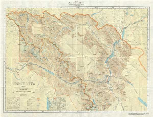
National Parks of Canada Jasper park Alberta North Sheet.
sold
- Digital Map Information
- Suitable for large format printing
- Full resolution TIFF file
- ICC color profile embedded
- Delivered instantly via download link
This is a nice example of the 1939 topographical survey chart or map of the beautiful Jasper National Park in Alberta, Canada, part of the Canadian Rockies. The map covers the northern part of the park and its vicinity. Throughout, the map marks railroad ... (more details)
Early map of France noting the newly acquired territories of Lorraine and Artois.
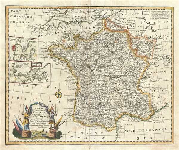
A New and Accurate map of France with its Acquisitions.
sold
- Digital Map Information
- Suitable for large format printing
- DPI: 300
- File Size: 10.31 MB
- File Type: ZIP / TIFF
- ICC color profile embedded
- Delivered instantly via download link
A beautiful example of Emanuel Bowen’s 1747 map of France. The map depicts the entire Kingdom of France including the newly acquired regions of Lorraine and Artois. The map renders the entire region in extraordinary detail, noting mountains, rivers, ... (more details)
Decorative map of the Iberian Peninsula.
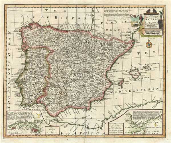
A New and Accurate Map of Spain and Portugal.
sold
- Digital Map Information
- Suitable for large format printing
- DPI: 300
- File Size: 9.7 MB
- File Type: ZIP / TIFF
- ICC color profile embedded
- Delivered instantly via download link
This is a charming map of Spain and Portugal by the English cartographer Emanuel Bowen. It depicts the Iberian Peninsula including the islands of Majorca, Minorca and Ibiza. The map renders the entire region in extraordinary detail, noting mountains, ... (more details)
Lovely map of Banff Park in Canada, one of the world's most visited national parks.
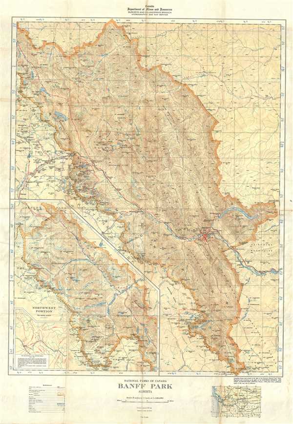
National Parks of Canada Banff park Alberta.
sold
- Digital Map Information
- Suitable for large format printing
- Full resolution TIFF file
- ICC color profile embedded
- Delivered instantly via download link
This is a nice example of the 1939 topographical survey chart or map of the beautiful Jasper National Park in Alberta, Canada. The map covers the entire park and its vicinity. Throughout, the map marks railroad lines, roads, trails, marshes, rapids, ... (more details)
An unusual and uncommon post-World War II propaganda broadside map calling for global support in the reconstruction of France.

France's Recovery is Europe's need and a guarantee for World Peace. / By the side of those with whom she fought against the Nazi Oppressor...
sold
- Digital Map Information
- Suitable for large format printing
- File Size: 56.59 MB
- File Type: ZIP / TIFF
- ICC color profile embedded
- Delivered instantly via download link
An unusual and uncommon post-World War II propaganda broadside map calling for global support in the reconstruction of France. This curiosity was issued c. 1945 in New York City by the French Press and Information Service, a New York based agency of ... (more details)
Scarce promotional cartoon map illustrating the routes of the Panama Mail Steamship Company.
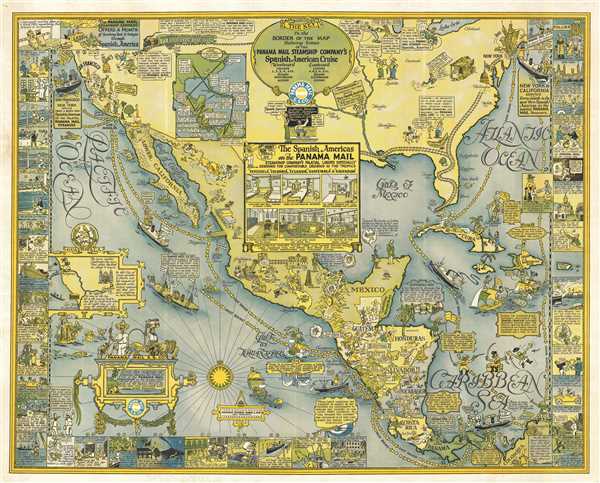
Panama Mail S.S. Co. The Sea Coastes of America shewing the Ports of call of the Panama Mail steamships as the Country there aboutes is lying and situated, with all the havens thereof. Exactly done and corrected with great diligence.
sold
- Digital Map Information
- Suitable for large format printing
- File Size: 51.39 MB
- File Type: ZIP / TIFF
- ICC color profile embedded
- Delivered instantly via download link
An extremely scarce 1928 pictorial map by Harrison Godwin promoting the routes of the Panama Mail Steam Ship Company. In Godwin's classic style, the map humorously covers North American from New York and San Francisco south to Columbia, including all ... (more details)
The first view to illustrate the devastation following the Chicago Fire of 1874.

The City of Chicago, Showing the Burnt District.
sold
- Digital Map Information
- Suitable for large format printing
- Full resolution TIFF file
- ICC color profile embedded
- Delivered instantly via download link
A dramatic journalistic view of Chicago, Illinois prepared to illustrate the devastation following the Chicago Fire of 1874. Issued just two weeks after the tragic fire (July 14, 1874), this is one of the first publications to illustrate the full ... (more details)
Rare map of Portland, Maine.

Portland.
sold
- Digital Map Information
- Suitable for large format printing
- File Size: 6.53 MB
- File Type: ZIP / TIFF
- ICC color profile embedded
- Delivered instantly via download link
This is a rare map of Portland issued c.1885. It covers downtown Portland and Casco Bay. Towns of Deering and Cape Elizabeth are noted along with various islands in Casco Bay. Portland’s development at this time was confined to the isthmus ... (more details)
Beautiful view of Casco Bay near Portland, Maine.

Birds Eye View of Casco Bay: Portland, Maine and Surroundings.
sold
- Digital Map Information
- Suitable for large format printing
- Full resolution TIFF file
- ICC color profile embedded
- Delivered instantly via download link
This is a beautiful 1906 bird’s eye-view map of Casco Bay, Portland, Maine issued by George Walker and Co. It covers Casco Bay, an inlet of the Gulf of Maine on the southern coast of Maine, from Port Elizabeth and South Portland with ... (more details)
Bird's Eye View of Puget Sound and Vicinity, Washington and British Columbia, Canada.
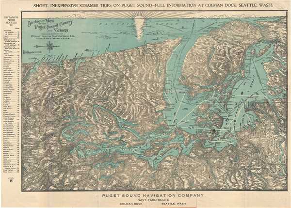
Birdseye View of Puget Sound Country and Vicinity.
sold
- Digital Map Information
- Suitable for large format printing
- Full resolution TIFF file
- ICC color profile embedded
- Delivered instantly via download link
An unusual and attractive c.1927 bird’s eye view map of Puget Sound, Washington and vicinity issued by the Puget Sound Navigation Company. The view is oriented with north to the right and covers from the Columbia River northward as ... (more details)
Charming bird's eye-view promoting Canadian tourism issued during the Chicago World's Fair.

Canada from Sea to Sea.
sold
- Digital Map Information
- Suitable for large format printing
- Full resolution TIFF file
- ICC color profile embedded
- Delivered instantly via download link
This highly appealing map or view of Canada was published for the Century of Progress Exposition held in Chicago in 1933. Issued as a promotional brochure encouraging development and tourism, the map features a bird’s eye view of ... (more details)
The original map upon which the northern Manhattan street grid is based.

Map of that Part of the City of New York North of 155th Street Showing the progress made in laying out Streets, Roads, Public Squares, and Places, by the Commissioners of the Central Park, under Chap. 565 of Laws of 1865 and of new Pier and Bulkhead lines under Chap. 697 of Laws of 1867.
sold
- Digital Map Information
- Suitable for large format printing
- File Size: 18.08 MB
- File Type: ZIP / TIFF
- ICC color profile embedded
- Delivered instantly via download link
A rare and unusual map of upper Manhattan, New York City, prepared and printed for inclusion in the 1870 Thirteenth Annual Report of the Board of Commissioners of the Central Park. It depicts the island of Manhattan north of 155th ... (more details)
Impressing first edition map of Maine.
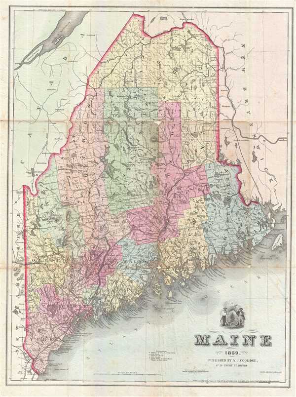
Maine.
sold
- Digital Map Information
- Suitable for large format printing
- Full resolution TIFF file
- ICC color profile embedded
- Delivered instantly via download link
This is an excellent 1859 map of Maine by A. J. Coolidge. It covers the entire state as well as adjacent parts of Canada and New Hampshire. The map details the proposed St. Andrews and Quebec Railway, construction of which was ... (more details)
Scarce 19th century map depicting Vermont.

Vermont.
sold
- Digital Map Information
- Suitable for large format printing
- Full resolution TIFF file
- ICC color profile embedded
- Delivered instantly via download link
This is an excellent 1859 map of Vermont by A. J. Coolidge. This example covers the entire state as well as adjacent parts of New Hampshire and New York. It is very uncommon to find a mid-19th century exclusively depicting ... (more details)
Scarce 19th century map of New Hampshire.

New Hampshire.
sold
- Digital Map Information
- Suitable for large format printing
- Full resolution TIFF file
- ICC color profile embedded
- Delivered instantly via download link
This is an excellent 1859 map of New Hampshire by A. J. Coolidge. One of the few maps specifically of New Hampshire published in the mid- 19th century; this example covers the entire state as well as adjacent parts of ... (more details)
Beautiful pictorial map of Tokyo.
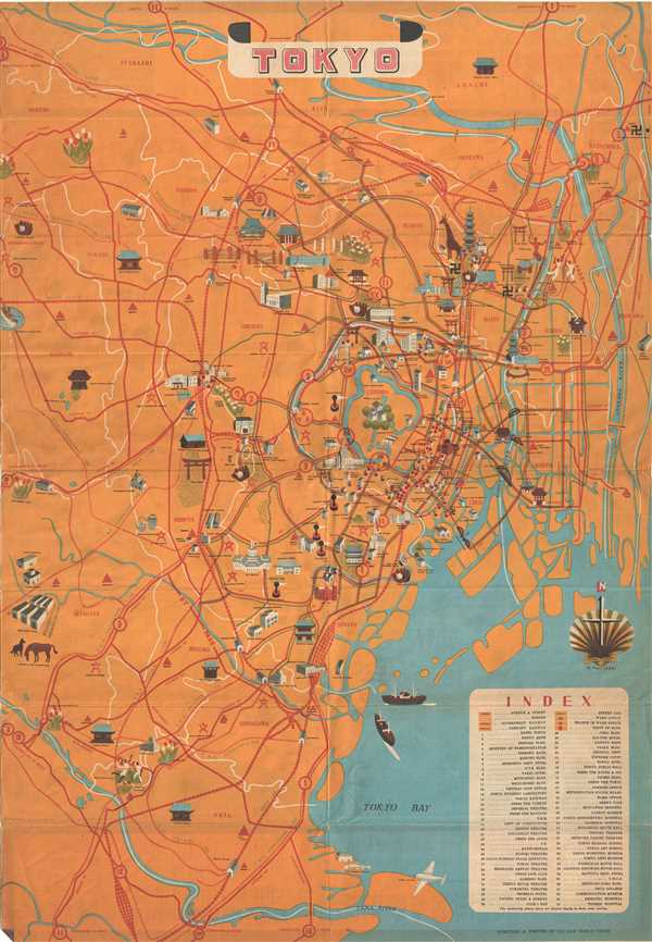
Tokyo.
sold
- Digital Map Information
- Suitable for large format printing
- Full resolution TIFF file
- ICC color profile embedded
- Delivered instantly via download link
This is a beautiful c. 1950 pictorial map of Tokyo, Japan issued by the New World Press. Centered on the Imperial Palace, it covers from Tama River north to Itabashi. Throughout the map features beautifully ... (more details)