
One of the most decorative maps of Brooklyn to appear in the 19th century.

Map of the City of Brooklyn.
sold
- Digital Map Information
- Suitable for large format printing
- Full resolution TIFF file
- ICC color profile embedded
- Delivered instantly via download link
An extremely attractive example of William Bishop's 1871 map of the city of Brooklyn, New York. In the mid-19th century, fueled by the advent of the steam ferry, which made crossing the east River practical, Kings County experienced a massive population burst. ... (more details)
An iconic American World War II propaganda broadside map by revolutionary cartography Richard Edes Harrison.
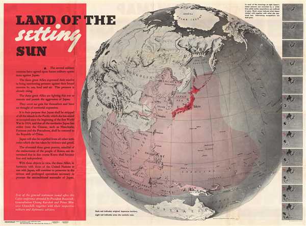
Land of the Setting Sun; Newsmap, Monday December 27, 1943.
sold
- Digital Map Information
- Suitable for large format printing
- File Size: 81.19 MB
- File Type: ZIP / TIFF
- ICC color profile embedded
- Delivered instantly via download link
An iconic American World War II propaganda broadside map by the cartographic innovator Richard Edes Harrison illustrating, as projected on the hemisphere, the expansion of the Japanese Empire. The broadside, Land of the Setting Sun , formally entitled Newsmap. ... (more details)
Stunning pictorial map of Quebec City, Quebec.
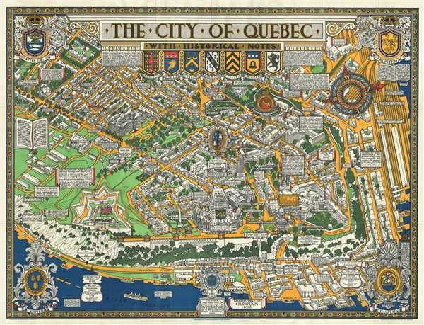
The City of Quebec with Historical Notes.
sold
This is an exceptional 1932 bird’s eye view map of the city of Quebec, Canada by Samuel Herbert Maw. This pictorial map beautifully captures the old city of Quebec in exceptional detail with the St. Lawrence River around it. Individual streets are noted, ... (more details)
One of the most decorative maps of Southern California.

Ride the Roads to Romance along the Golden Coast and thru the Sunshine Empire of Southern California.
sold
- Digital Map Information
- Suitable for large format printing
- File Size: 38.56 MB
- File Type: ZIP / TIFF
- ICC color profile embedded
- Delivered instantly via download link
This is an attractive 1963 bird’s eye view map of southern California issued by the Southern California Tourist Association, Inc. It covers from Malibu Beach to Ensenada in Mexico and includes the counties of Los Angeles, Orange, Riverside, San Diego, ... (more details)
Stunning panoramic view of the Niagara Falls and the Great Gorge Route.

Niagara's Great Gorge Trip The Falls and Whirlpool Rapids Route.
sold
- Digital Map Information
- Suitable for large format printing
- Full resolution TIFF file
- ICC color profile embedded
- Delivered instantly via download link
This is a beautiful 1930 panorama of the Niagara Falls by the Whitney Graham Company. This bird’s eye view style map depicts the Niagara Gorge and the Great Gorge Route or the Niagara Belt Line. Along the way, several important monuments and events ... (more details)
1752 Vaugondy Map of the Aquitaine Region: Bourdelois, Perigord, Gironde (Bordeaux Wine Region), Fra
Covers the Bordeaux Wine Regions.

Partie Septentrionale du Gouvernement General de la Guienne ou se trouvent le Bourdelois, Le Perigord, l'Agenois, le Bazadois, et une partie du Condomois et de la Lomagne.
sold
- Digital Map Information
- Suitable for large format printing
- Full resolution TIFF file
- ICC color profile embedded
- Delivered instantly via download link
This is an attractive 1752 map by Robert de Vaugondy of the province of Guyenne, now forming part of the Aquitane region in southwestern France. It depicts the counties of Perigord, Bordelais (Bordeaux), Bazadais and Agenais roughly corresponding to ... (more details)
Early map of northeastern Poland and Lithuania.
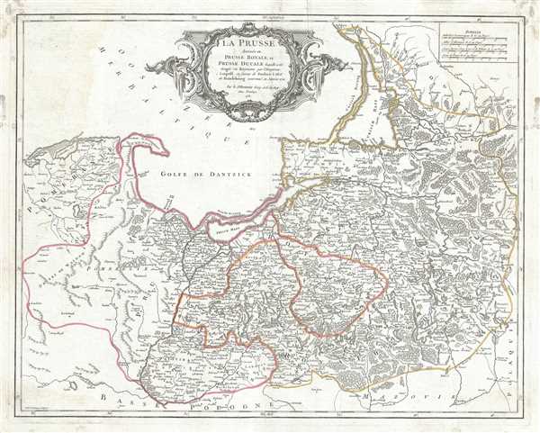
La Prusse divisee en Prusse Royale, et Prusse Ducale laquelle a ete erigee en Royaume par l'Empereur Leopold en favour de Frederic I. Elec? de Brandebourg couronee en Janvier 1701.
$350.00
Acquire
- Digital Map Information
- Suitable for large format printing
- Full resolution TIFF file
- ICC color profile embedded
- Delivered instantly via download link
This is a beautiful 1751 map of Prussia by Robert de Vaugondy. It covers the northeastern part of Poland and Lithuania and extends from Grodno and the Spirding-See in Poland north to Klaipeda in Lithuania and west as far as Leba and depicts the Holy ... (more details)
Japanese World War II map of Java and Bali

Java.
sold
- Digital Map Information
- Suitable for large format printing
- Full resolution TIFF file
- ICC color profile embedded
- Delivered instantly via download link
This is a scarce 1943 Japanese map of Java and surrounding islands, including Bali, Indonesia, issued during World War II. The southern part of Sumatra and Borneo is also included. The map offers superb detail regarding both topographical elements. ... (more details)
Japanese World War II map of Sumatra and the Malay Peninsula

Malay and Sumatra.
sold
- Digital Map Information
- Suitable for large format printing
- Full resolution TIFF file
- ICC color profile embedded
- Delivered instantly via download link
This is a scarce 1943 or Showa 18 large format Japanese map of the Malay Peninsula (Malaysia) including Singapore and Sumatra, Indonesia. The map covers the Malay Peninsula including Singapore as well as the island of Sumatra, Indonesia. This map ... (more details)
Japanese World War II map of Malay and Singapore.
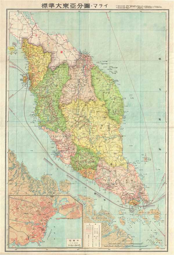
Malay.
sold
- Digital Map Information
- Suitable for large format printing
- Full resolution TIFF file
- ICC color profile embedded
- Delivered instantly via download link
This is a scarce 1943 World War II era Japanese map of the Malaya Peninsula (Malaysia) and Singapore Island. It covers the peninsula in considerable detail noting both physical and political elements with inset city plan in the lower left ... (more details)
Japanese World War II map of Eastern Australia.
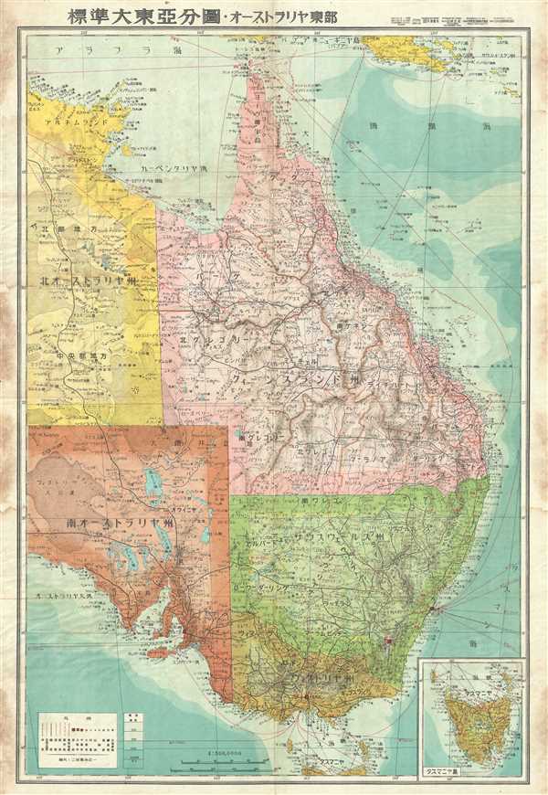
Eastern Australia.
sold
- Digital Map Information
- Suitable for large format printing
- Full resolution TIFF file
- ICC color profile embedded
- Delivered instantly via download link
This is a stunning 1943 or Showa 18 large format map of eastern Australia issued by the Japanese during World War II as part of a series of maps promoting the Japanese imperialist concept of the Greater East Asia Co-Prosperity Sphere. It covers the eastern half of the continent including Queensland, New South Wales, Victoria and the eastern parts of South Australia and Northern Territory. An inset of Tasmania is included in the lower right quadrant. The map offers superb detail regarding both topographical and political elements. Cities, roads, and air, sea, and land trade routes are illustrated. Shading indicates oceanic depths. While Allied World War II maps of this region are fairly common, it is extremely rare to come across their Japanese counterparts. All text is in Japanese. (more details)
Japanese World War II map of New Guinea.

New Guinea.
sold
- Digital Map Information
- Suitable for large format printing
- File Size: 3.74 MB
- File Type: ZIP / TIFF
- ICC color profile embedded
- Delivered instantly via download link
This is a stunning large format Japanese map of New Guinea dating to World War II. Covers the entirety of the island with color coding according to district. Offers superb detail regarding both topographical and political elements. ... (more details)
Large 18th century map of the Mediterranean region.
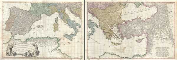
A Map of the Mediterranean Sea with the Adjacent Regions and Seas in Europe, Asia and Africa.
sold
- Digital Map Information
- Suitable for large format printing
- Full resolution TIFF file
- ICC color profile embedded
- Delivered instantly via download link
This is an appealing 1785 map of the Mediterranean region issued by William Faden. A set of two maps, the western sheet covers from Portugal, Spain, Italy, the Maghreb or the Barbary Coast of Africa and includes parts of France and ... (more details)
Attractive folding pocket map of Ireland.
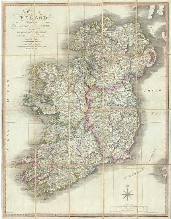
A Map of Ireland divided into Provinces and Counties, showing the Great and Cross Roads with the distances of the Principal Towns from Dublin.
sold
- Digital Map Information
- Suitable for large format printing
- Full resolution TIFF file
- ICC color profile embedded
- Delivered instantly via download link
This is an attractive 1798 map of Ireland by William Faden. It depicts the emerald isle in its entirety, divided into counties and provinces. It covers the four provinces, which remain the same to this day. In the north is ... (more details)
Scarce birds-eye view of Morristown - one of the first such views to incorporate photography.

Morristown N.J. 1899.
sold
- Digital Map Information
- Suitable for large format printing
- File Size: 75.49 MB
- File Type: ZIP / TIFF
- ICC color profile embedded
- Delivered instantly via download link
An extremely scarce and dramatic large format 1899 view of Morristown, New Jersey. Prepared by the Newark firm of Landis and Alsop, this view depicts Morristown from somewhere high above the eastern part of town looking ... (more details)
Remarkable presentation issue of an iconic birds-eye view of London, England.

Panorama of the River Thames in 1845. Given with the London Illustrated News.
sold
- Digital Map Information
- Suitable for large format printing
- Full resolution TIFF file
- ICC color profile embedded
- Delivered instantly via download link
This is a dramatic presentation copy of the scarce 1845 London Illustrated News panorama of London, England. Measuring some 96 inches long, this enormous production presents a birds-eye view of London as seen from far ... (more details)
18th century nautical chart of the coast of Taiwan or Formosa.
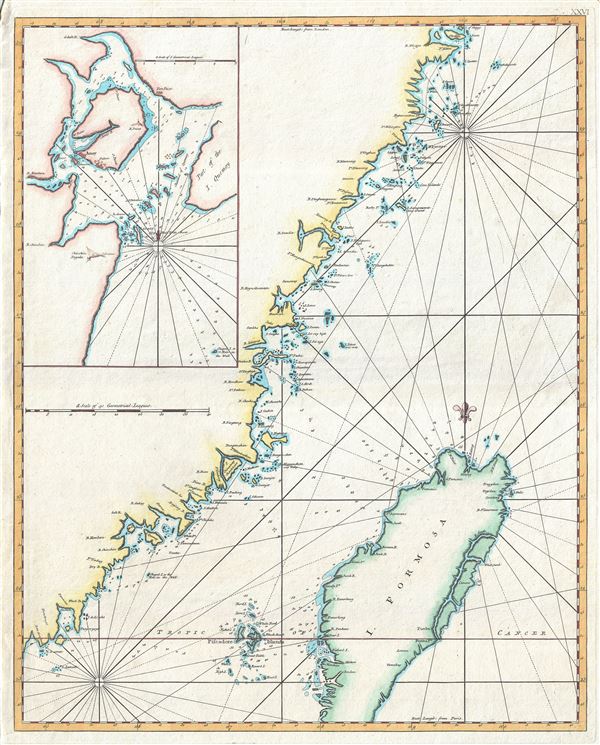
Carte de la coste orientale de la Chine depuis Amoy, jusqu'a Chusan avec une partie de l'Isle Formose. [untitled]
sold
- Digital Map Information
- Suitable for large format printing
- Full resolution TIFF file
- ICC color profile embedded
- Delivered instantly via download link
A scarce c.1780 British edition of D'Apres de Mannevillette's nautical chart or map of Taiwan (Formosa) and the mainland Fujian Coast, China. The map offers rich detail including countless depth soundings, notes on the ... (more details)
Beautiful award winning manuscript map of Latvia.

Letonia.
sold
- Digital Map Information
- Suitable for large format printing
- Full resolution TIFF file
- ICC color profile embedded
- Delivered instantly via download link
This is a charming 1939 manuscript or hand drawn map of Latvia or Letonia by Antonio Raggio. It covers the Republic of Latvia, one of the three Baltic states in Northern Europe. The map is beautifully detailed and ... (more details)
Charming manuscript map of Montenegro.

Montenegro.
sold
- Digital Map Information
- Suitable for large format printing
- Full resolution TIFF file
- ICC color profile embedded
- Delivered instantly via download link
This is a beautiful 1939 manuscript or hand drawn map of Montenegro by Antonio Raggio. It covers the European country of Montenegro in fine detail, noting rivers, cities, towns, lakes, roads and surrounding ... (more details)
Attractive 18th century map of the Iberian Peninsula showing postal routes.

Carte des Royaumes d'Espagne et de Portugal dans laquelle sont tracees les routes des postes.
sold
- Digital Map Information
- Suitable for large format printing
- Full resolution TIFF file
- ICC color profile embedded
- Delivered instantly via download link
This is a fine 1750 map of Spain and Portugal by Robert de Vaugondy. It covers the Iberian Peninsula including the islands of Majorca, Minorca and Ibiza and depicts the provinces as they appeared when the ... (more details)