

Canoe Map of Charles River Bird's-Eye View Showing Carriers, Dams, Etc.
sold
- Digital Map Information
- Suitable for large format printing
- Full resolution TIFF file
- ICC color profile embedded
- Delivered instantly via download link
This is a beautiful 1907 bird's-eye view style pocket canoe map of Charles River, Massachusetts by the Boston map publisher George H. Walker. Printed with a multicolor lithograph process, Walker's view covers the winding Charles River from Waltham to Medway and ... (more details)
Important first edition map of the Chesapeake Bay and environs by N. Bellin.
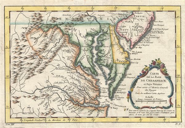
Carte de la Baye de Chesapeack et Pays Voisins.
sold
- Digital Map Information
- Suitable for large format printing
- DPI: 300
- File Size: 11.53 MB
- File Type: ZIP / TIFF
- ICC color profile embedded
- Delivered instantly via download link
Attributed to the French cartographer Jacques-Nicholas Bellin, this is a beautiful 1757 first state first edition map of the Chesapeake Bay including Virginia, Maryland, Delaware and parts of New Jersey and Pennsylvania. Bellin's map covers from Cape Henry north ... (more details)
The earliest obtainable map or plan of New Orleans, Louisiana.

Plan de la Nouvelle-Orleans sur les Manuscrits du Depot des Cartes de la Marine.
sold
- Digital Map Information
- Suitable for large format printing
- DPI: 300
- File Size: 3.15 MB
- File Type: ZIP / TIFF
- ICC color profile embedded
- Delivered instantly via download link
This scarce 1744 map by J. N. Bellin is the earliest obtainable map of New Orleans, Louisiana. Oriented to the northwest, Bellin's map covers the original settlement of New Orleans along the Mississippi River and inland as far the Fosse plein d'eau (roughly ... (more details)
Stunning Malta map showing the armorial crests of the Grand Masters of the Knights Hospitallers of St. John.

L'Isle de Malthe Et celles de Goze et de Comino, Avec leurs ou Ports, leurs Toursou Vedetes, qu'ils nomment Casati et leurs Precipices qu'ils appelant Redum . . . 1722.
sold
- Digital Map Information
- Suitable for large format printing
- DPI: 300
- File Size: 16.95 MB
- File Type: ZIP / TIFF
- ICC color profile embedded
- Delivered instantly via download link
A spectacular and scarce 1722 map of Malta by Estienne Vouillemont and Nicolas de Fer. De Fer's map covers all of Malta as well as the adjacent island of Gozo. Throughout the map offers exceptional topographical detail and is, in places, almost view-like. ... (more details)

South Sea Whale Fishery. A representation of the Ships Amelia Wilsona and Castor off the Island of Bouro with the Boats and Crew in the various process of Fishing, shewing the manner the Spermacetti Whales are caught also the mode of cutting them into to Ship, and Boiling the Oil upon the Deck.
sold
- Digital Map Information
- Suitable for large format printing
- DPI: 300
- File Size: 10.06 MB
- File Type: ZIP / TIFF
- ICC color profile embedded
- Delivered instantly via download link
An iconic 1825 lithograph illustrating the South Sea Whale Fishery. This view was engraved by T. Sutherland based upon a painting by W. J. Huggins, official Marine Painter to his Majesty. The illustration express the excitement, richness, romance, and ... (more details)
Scarce map of Nice, France, at the height of the Belle Epoque.

The Traveller's Companion Map of Nice-Town by R. Duquenoy and Foiret.
sold
- Digital Map Information
- Suitable for large format printing
- File Size: 4.75 MB
- File Type: ZIP / TIFF
- ICC color profile embedded
- Delivered instantly via download link
An exceptional c. 1890 map of Nice, France, at the height of its Belle Epoque splendor. Compiled for American travelers in the south of France, this map was composed by R. Duquenoy and Foiret. It covers the rapidly expanding coastal city and its ... (more details)
Majestic and revolutionary multi panel wall map of Paris.

Lutetia Paris.
sold
- Digital Map Information
- Suitable for large format printing
- Full resolution TIFF file
- ICC color profile embedded
- Delivered instantly via download link
This majestic nine panel plan of Paris is the c. 1900 Taride reissue of an important map originally issued in 1652 by Jacques Gomboust. Gomboust held the position of Ingenieur du Roi and, in that capacity completed a number of important survey's ... (more details)
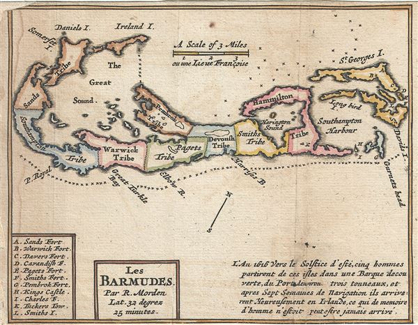
Les Barmudes.
sold
- Digital Map Information
- Suitable for large format printing
- Full resolution TIFF file
- ICC color profile embedded
- Delivered instantly via download link
This is a charming 1688 small format map of Bermuda by Robert Morden. It depicts the whole of Bermuda divided into tribes, including the Sands Tribe, Southampton Tribe, Warwick Tribe, Pagets Tribe, Pembrock Tribe, Devonsh Tribe, Smiths Tribe ... (more details)

Plan of Improvements of the Battery.
sold
- Digital Map Information
- Suitable for large format printing
- Full resolution TIFF file
- ICC color profile embedded
- Delivered instantly via download link
This is a scarce 1817 map of the Battery Park by Kellogg and Pilat. Located on the southern tip of Manhattan, Capske Hook or the Battery, as it was later called, was where the Dutch began their settlement of New Amsterdam (now New York) in ... (more details)
1871 Kellogg and Pilat Map of the Southeast Corner of Central Park (Grand Army Plaza), New York City
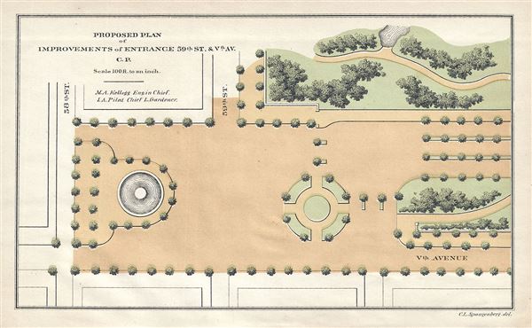
Proposed Plan of Improvements of Entrance 59th St. and Vth Av. C.P.
sold
- Digital Map Information
- Suitable for large format printing
- Full resolution TIFF file
- ICC color profile embedded
- Delivered instantly via download link
This is a beautiful and unusual little map of the southeastern corner of New York City's Central Park by Kellogg and Pilat dating to 1871. It depicts the southeast corner of Central Park from the intersection of 58th street and 5th Avenue ... (more details)
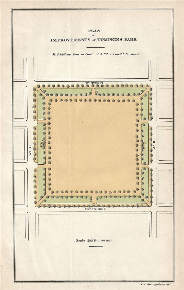
Plan of Improvements of Tompkins Park.
sold
- Digital Map Information
- Suitable for large format printing
- Full resolution TIFF file
- ICC color profile embedded
- Delivered instantly via download link
This is a rare 1871 example of Kellogg and Pilat's plan for the improvements of Tompkins Square Park, New York City. Tompkins Square Parks, located between Avenue A and Avenue B and 7th St. and 10th St. in New York City's Alphabet City, ... (more details)

Proposed Plan of Improvements of Reservoir Park.
sold
- Digital Map Information
- Suitable for large format printing
- Full resolution TIFF file
- ICC color profile embedded
- Delivered instantly via download link
This is a rare and beautiful 1871 map or plan of Reservoir Park or Bryant Park by Kellogg and Pollard. The plan covers what is today known as Bryant Park, located in Midtown Manhattan. Before Bryant Park became public property in 1686, ... (more details)
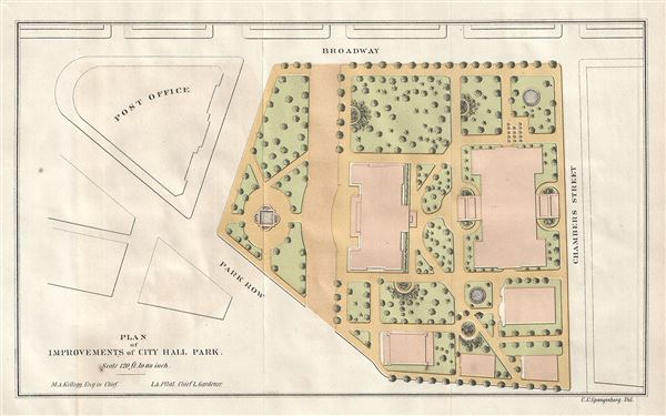
Plan of Improvements of City Hall Park.
sold
- Digital Map Information
- Suitable for large format printing
- Full resolution TIFF file
- ICC color profile embedded
- Delivered instantly via download link
A scarce 1871 map of City Hall Park in New York City by Kellogg and Pilat. The plan covers City Hall Park, the seat of the City government, located in downtown Manhattan. In the late 17th century, the area was a pasture outside city ... (more details)

Plan of Improvements of Washington Park.
sold
- Digital Map Information
- Suitable for large format printing
- Full resolution TIFF file
- ICC color profile embedded
- Delivered instantly via download link
This is a rare and beautiful 1871 map of Washington Square Park, New York City by Kellogg and Pilat. Named after George Washington, the area was originally a marsh which was later converted into a Potter's Field, used to bury the ... (more details)
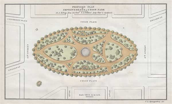
Proposed Plan of Improvements of Union Park.
sold
- Digital Map Information
- Suitable for large format printing
- Full resolution TIFF file
- ICC color profile embedded
- Delivered instantly via download link
This is a rare and important 1871 example of Kellogg and Pollard Map or plan of Union Square, New York City. The Commissioners' Plan of 1811 united Bowery Road (now 4th Avenue) and Bloomingdale St. (now Broadway), and the former ... (more details)
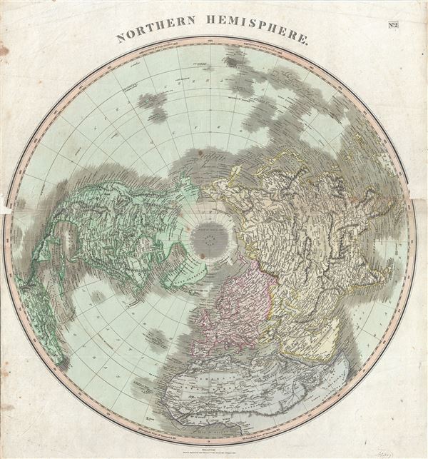
Northern Hemisphere.
sold
- Digital Map Information
- Suitable for large format printing
- Full resolution TIFF file
- ICC color profile embedded
- Delivered instantly via download link
This fascinating hand colored 1814 map by Edinburgh cartographer John Thomson depicts the Northern Hemisphere from the Arctic to the Equator. Includes all of North America, Europe, and Asia as well as the northern part of Africa ... (more details)

Sketch B. No. 3 Showing the Triangulation and Geographical Positions in Section no. II From New York City to Cape Henlopen.
sold
- Digital Map Information
- Suitable for large format printing
- Full resolution TIFF file
- ICC color profile embedded
- Delivered instantly via download link
This is an exceptional example of the 1851 U.S. Coast Survey's nautical chart or maritime map for New Jersey and the Delaware Bay. It covers the coast line from New York City south through New Jersey to Cape Henlopen, and from ... (more details)
The first map to depict Manhattan as an Island and to illustrate a beaver.

Nova Belgica et Anglia Nova.
sold
- Digital Map Information
- Suitable for large format printing
- DPI: 300
- File Size: 10.86 MB
- File Type: ZIP / TIFF
- ICC color profile embedded
- Delivered instantly via download link
A beautiful example of one of the most important maps in the history of America, Blaeu's 1635 Nova Belgica et Anglia Nova . Oriented to the west, this map covers the American coast from Virginia, past New York and Long Island ... (more details)

Map of the World from the latest Discoveries.
sold
- Digital Map Information
- Suitable for large format printing
- Full resolution TIFF file
- ICC color profile embedded
- Delivered instantly via download link
This is a fine 1793 map of the world in hemispheres by Robert Wilkinson. Wilkinson's map covers the entire world with color coding by continent. The exploratory routes taken by cook are noted. In Australia, here labeled New ... (more details)
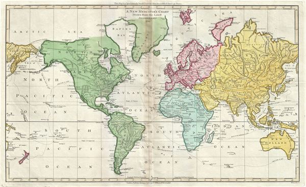
A New Mercator's Chart Drawn from the Latest Discoveries.
sold
- Digital Map Information
- Suitable for large format printing
- Full resolution TIFF file
- ICC color profile embedded
- Delivered instantly via download link
This is a finely detailed 1791 map of the world on a Mercator projection by Robert Wilkinson. Wilkinson's map covers the entire world with color coding by continent. The exploratory routes taken by Captain Cook are noted. ... (more details)