
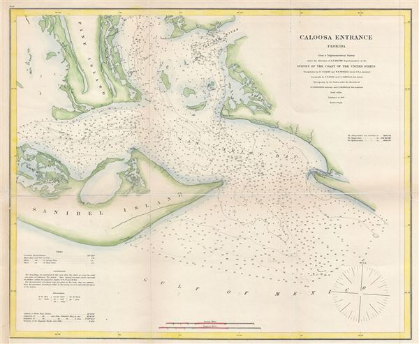
Caloosa Entrance Florida.
sold
- Digital Map Information
- Suitable for large format printing
- File Size: 12.36 MB
- File Type: ZIP / TIFF
- ICC color profile embedded
- Delivered instantly via download link
This is a beautiful example of the 1867 U.S. Coast Survey nautical chart or maritime map of the entrance to the Caloosa (Caloosahatchee) River in Florida. Centered on the San Carlos Bay, this map covers from the eastern portion of Sanibel Island to the entrance of ... (more details)
Features manuscript annotation referring to the 1887 America's Cup Yacht Race.

Coast Chart No. 20 New York Bay and Harbor New York.
sold
- Digital Map Information
- Suitable for large format printing
- File Size: 16.13 MB
- File Type: ZIP / TIFF
- ICC color profile embedded
- Delivered instantly via download link
This is a rare 1866 U.S. Coast Survey nautical chart or maritime map of New York City, its harbor, and environs. Though variants of this chart appeared earlier, the present example is most likely the first independent issue of this map in its full completed form. ... (more details)

Entrance to San Francisco Bay California.
sold
- Digital Map Information
- Suitable for large format printing
- File Size: 34.43 MB
- File Type: ZIP / TIFF
- ICC color profile embedded
- Delivered instantly via download link
This is a beautiful example of the 1859 U. S. Coast Survey nautical chart or maritime map of the entrance to San Francisco Bay and San Francisco itself. Centered on the City of San Francisco, the map covers the Golden Gate Area, the Marin Peninsula, Mission de ... (more details)
One of only two known surviving examples of a scarce chart.
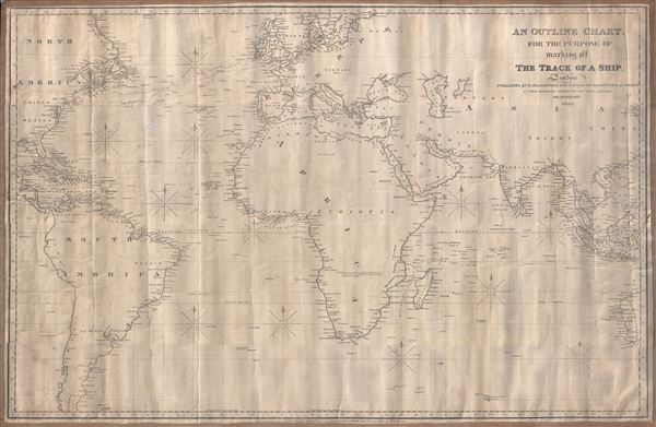
An Outline Chart for the Purpose of Marking off the Track of a Ship.
sold
- Digital Map Information
- Suitable for large format printing
- Full resolution TIFF file
- ICC color profile embedded
- Delivered instantly via download link
A large 1846 blueback nautical chart or maritime map of the world by Robert Blachford. Centered on a large and prominent Africa, this map covers most of the world excluding the Arctic climes from roughly the Orkney Islands to the Falkland Islands and from Yucatan (Mexico) to Borneo and Western Australia. Blachford intended this map for marking the route of a ship along the more common maritime routes - to the Americas and around Africa to India and the East Indies. It notably does not include the Pacific, an area in which Blachford had little interest. Notations in pencil indicate that this chart was used to mark off repeat voyages between England and the Americas, specifically New England and the West Indies. (more details)
One of the most beautiful, important, and enduring maps of Manhattan ever published.
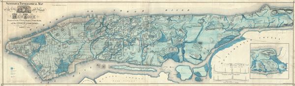
Sanitary and Topographical Map of the City and Island of New York Prepared for the Council of Hygene and Public Health, of the Citizens' Association under the direction of Egbert L. Viele, Topographical Engineer.
sold
- Digital Map Information
- Suitable for large format printing
- File Size: 51.42 MB
- File Type: ZIP / TIFF
- ICC color profile embedded
- Delivered instantly via download link
This is Egbert L. Viele's 1865 topography and waterways map of Manhattan, one of the scarcest, most important and most enduring maps of New York City ever published. Covering the entirety of Manhattan Island, Viele's map details the canals, swamps, rivers, ... (more details)
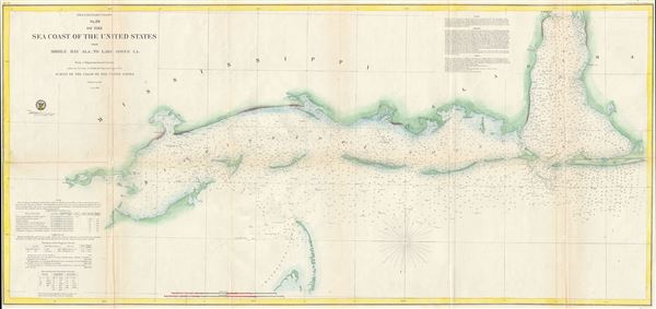
Preliminary Chart No. 26 of the Sea Coast of the United States from Mobile Bay Ala. to Lake Bogue LA.
sold
- Digital Map Information
- Suitable for large format printing
- File Size: 4.01 MB
- File Type: ZIP / TIFF
- ICC color profile embedded
- Delivered instantly via download link
This is beautiful hand colored example of the 1857 U. S. Coast Survey nautical chart or maritime map of the Gulf Coast from Mobile Bay, Alabama to Borgne (Bogue) Lake, Louisiana. Centered on the Mississippi Sound, the map extends westward as far as Rabbit ... (more details)

Preliminary Chart of Rappahannock River Virginia from Entrance to Deep Creek.
sold
- Digital Map Information
- Suitable for large format printing
- File Size: 15.09 MB
- File Type: ZIP / TIFF
- ICC color profile embedded
- Delivered instantly via download link
This is an attractive hand colored example of the 1857 U. S. Coast Survey nautical chart or maritime map of the Rappahannock River, Virginia. The map focuses on the southern part of the Rappahannock River from where it enters into the Chesapeake Bay, and ... (more details)

Regionis Biturigum Exactiss: Descriptio per D. Ioannem Calamaeum. Limaniae Topographia Gabriele Symeoneo Auct.
sold
- Digital Map Information
- Suitable for large format printing
- DPI: 300
- File Size: 10.49 MB
- File Type: ZIP / TIFF
- ICC color profile embedded
- Delivered instantly via download link
These are two rare 1579 regional Abraham Ortelius maps on a single folio sheet. The Left Map, centered on Bourges, depicts the Loire Valley region from Gian to St. Sebastian in the south and from Le Blanc east as far as Nevers. Several important cities ... (more details)
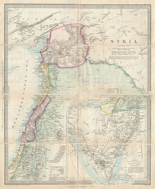
Syria.
sold
- Digital Map Information
- Suitable for large format printing
- File Size: 8.37 MB
- File Type: ZIP / TIFF
- ICC color profile embedded
- Delivered instantly via download link
This is a scarce 1858 map of Syria, Israel and the Holy Land prepared by William Hughes. Centered on Syria, it covers from Asia Minor to the Dead Sea. The map is continued on the same scale, from the Dead Sea to Mount Sinai, in a large inset in the ... (more details)
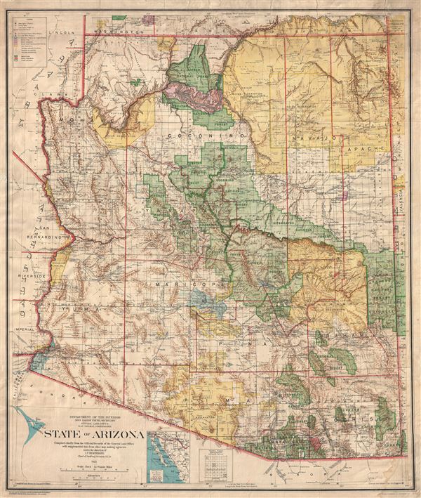
State of Arizona compiled chiefly from the official records of the General Land Office with supplemental data from other map making agencies, under the direction of I.P. Berthrong, chief of drafting division, G.L.O.
sold
- Digital Map Information
- Suitable for large format printing
- File Size: 47.75 MB
- File Type: ZIP / TIFF
- ICC color profile embedded
- Delivered instantly via download link
A remarkable and uncommon 1921 large format map of Arizona prepared by Daniel P. O'Hare and I. P. Berthrong for the General Land Office. This massive map, which covers the entire state as well as adjacent portions its neighbors, is intended to ... (more details)
Scarce Grierson's Piracy of Tiddeman's important map of New York City and Harbor.
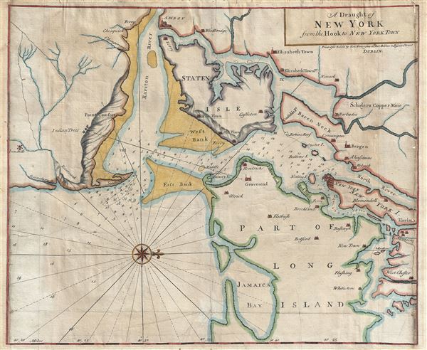
A Draught of New York from the Hook to New York Town.
sold
- Digital Map Information
- Suitable for large format printing
- DPI: 300
- File Size: 18.87 MB
- File Type: ZIP / TIFF
- ICC color profile embedded
- Delivered instantly via download link
A scarce and impressive colonial period 1749 George Grierson / Mark Tiddeman nautical chart of New York City and harbor. Oriented to the west and centered on Coney Island (Cunny I.), Grierson's chart covers from Staten Island to Jamaica Bay and ... (more details)
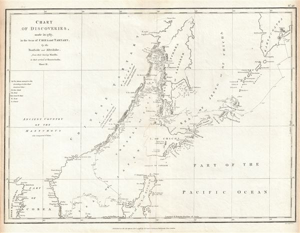
Chart of the Discoveries made in 1787, in the Seas of China and Tartary by the Boussole and Astrolabe from their leaving Manilla and Arriving in Kamtschatka, Sheet II.
sold
- Digital Map Information
- Suitable for large format printing
- DPI: 300
- File Size: 7.79 MB
- File Type: ZIP / TIFF
- ICC color profile embedded
- Delivered instantly via download link
This is a fine example of La Perouse's important 1787 mapping of the Sea of Japan and the Sea of Okhotsk. The map covers the region from the coast of southern Kamchatka south as far as northern Japan and Korea. The eastern coasts of China and ... (more details)

Carte des Indes orientales I. feuille, dans la quelle on represente les Indes deca la Riviere de Ganges, le Golfe de Bengale, Siam, Malacca, Sumatra dressee par Mr. de Tobie Mayer de la Societe Geograph.
sold
- Digital Map Information
- Suitable for large format printing
- DPI: 300
- File Size: 13.91 MB
- File Type: ZIP / TIFF
- ICC color profile embedded
- Delivered instantly via download link
This is an attractive example of the western sheet of the Homann Heirs' 1748 map of India and Southeast Asia. It details the subcontinent as well as much of Southeast Asia, including modern day Burma, Thailand, Laos, Malaysia, Singapore and ... (more details)

Einde van den Slag. Fin du Combat.
sold
- Digital Map Information
- Suitable for large format printing
- DPI: 300
- File Size: 9.17 MB
- File Type: ZIP / TIFF
- ICC color profile embedded
- Delivered instantly via download link
This is a beautiful 1782 view illustrated by J. F. Reitz depicting the Battle of Dogger Bank during the American Revolutionary War. This view beautifully depicts the bloody battle between the Dutch and English ships during the fourth ... (more details)
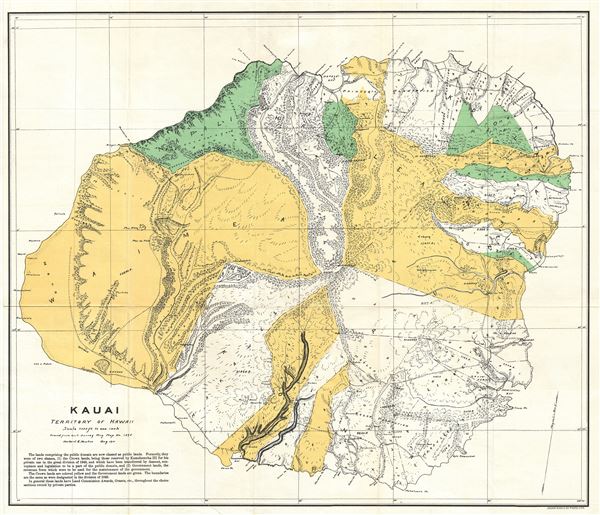
Kauai Territory of Hawaii.
sold
- Digital Map Information
- Suitable for large format printing
- File Size: 11.5 MB
- File Type: ZIP / TIFF
- ICC color profile embedded
- Delivered instantly via download link
This is a rare and beautiful 1901 Land Office map of the island of Kauai, Hawaii, prepared for the 1900 Report of the Governor of the Territory of Hawaii to the Secretary of the Interior. Kauai is the fourth largest Hawaiian Island ... (more details)
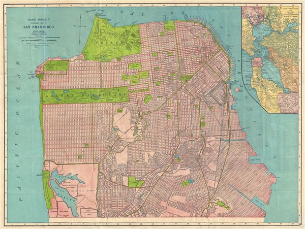
Rand McNally Standard Map of San Francisco.
sold
- Digital Map Information
- Suitable for large format printing
- File Size: 19.16 MB
- File Type: ZIP / TIFF
- ICC color profile embedded
- Delivered instantly via download link
This is a beautiful map of the city of San Francisco, California, issued by the Rand McNally and Company in 1927. It covers the entire city from Fort Point and Presidio Park as far south as the Laguna de la Merced. The map is ... (more details)
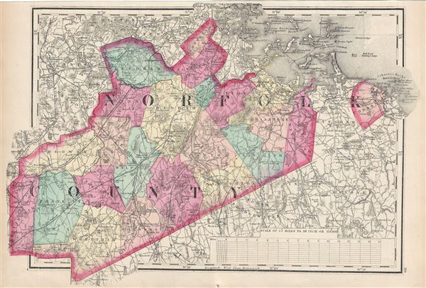
[Norfolk County].
sold
- Digital Map Information
- Suitable for large format printing
- File Size: 8.21 MB
- File Type: ZIP / TIFF
- ICC color profile embedded
- Delivered instantly via download link
This is a fine example of Walling and Gray's 1871 map of Norfolk County, Massachusetts. It covers the entire county along with parts of neighboring counties. The city of Boston is highly detailed. Needham, Brookline, Dover, ... (more details)

City of New Bedford.
sold
- Digital Map Information
- Suitable for large format printing
- File Size: 7.22 MB
- File Type: ZIP / TIFF
- ICC color profile embedded
- Delivered instantly via download link
A lovely 1871 map of the city of New Bedford, Massachusetts, by H. F. Walling and O. W. Gray. Centered on Acushnet River, the map covers the city from Sawyer St. to Cove St. and from Oak Grove Cemetery to Summer St. Color ... (more details)
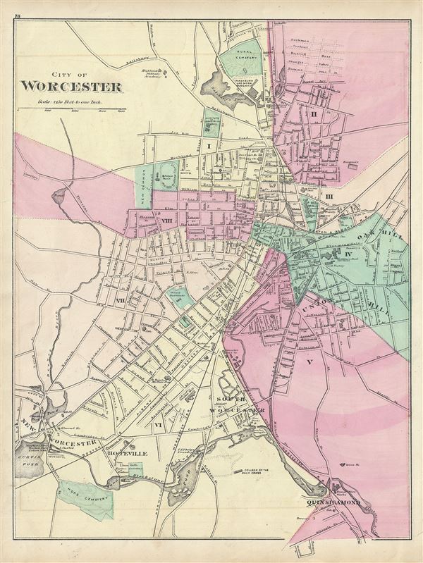
City of Worchester.
sold
- Digital Map Information
- Suitable for large format printing
- File Size: 7.6 MB
- File Type: ZIP / TIFF
- ICC color profile embedded
- Delivered instantly via download link
This is a fine example of Walling and Gray's 1871 map of the city of Worchester, Massachusetts. It covers the city from Salisbury Pond to Quinsigamond and Hop Cemetery. Color coded according to wards, the map is highly ... (more details)
Features manuscript annotation referring to the 1887 America's Cup Yacht Race.
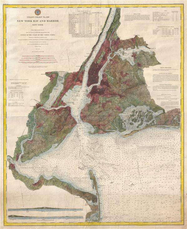
Coast Chart No. 120 New York Bay and Harbor New York.
sold
- Digital Map Information
- Suitable for large format printing
- File Size: 33.34 MB
- File Type: ZIP / TIFF
- ICC color profile embedded
- Delivered instantly via download link
This is a rare U.S. Coast Survey nautical chart or maritime map of New York City, its harbor, and environs. First appearing in its completed form in 1866, this is among the first 19th century charts to depict New York ... (more details)