
Dual Hemisphere Set.

Western Hemisphere. Eastern Hemisphere.
sold
- Digital Map Information
- Suitable for large format printing
- Full resolution TIFF file
- ICC color profile embedded
- Delivered instantly via download link
This is a beautiful set of two maps of the World on hemispherical projections from Sidney Hall's extremely scarce 1835 New General Atlas . They depict the Western and Eastern Hemispheres offering a fascinating snapshot of the world during a period of rapid ... (more details)
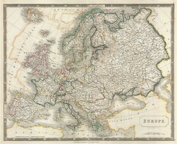
Europe.
sold
- Digital Map Information
- Suitable for large format printing
- DPI: 300
- File Size: 15.52 MB
- File Type: ZIP / TIFF
- ICC color profile embedded
- Delivered instantly via download link
This is a beautiful map of Europe from Sidney Hall's extremely scarce 1835 New General Atlas . It covers the entire continent from the Atlantic Ocean to the Ural Mountains and from the Arctic Ocean to northern Africa and Turkey, including Iceland. It ... (more details)
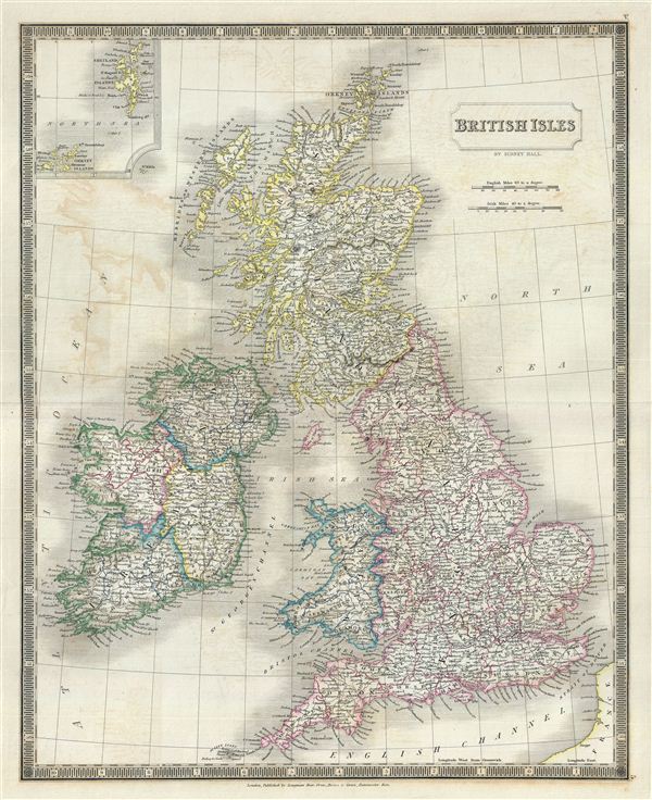
British Isles.
sold
- Digital Map Information
- Suitable for large format printing
- DPI: 300
- File Size: 15.56 MB
- File Type: ZIP / TIFF
- ICC color profile embedded
- Delivered instantly via download link
This is a beautiful map of the British Isles from Sidney Hall's extremely scarce 1835 New General Atlas . It includes England, Scotland and Ireland and covers from the Orkney Islands to the Scilly Isles in the south. An inset in the upper left ... (more details)

England and Wales.
sold
- Digital Map Information
- Suitable for large format printing
- DPI: 300
- File Size: 15.97 MB
- File Type: ZIP / TIFF
- ICC color profile embedded
- Delivered instantly via download link
This is a beautiful map of England and Wales from Sidney Hall's extremely scarce 1835 New General Atlas . It covers both England and Wales from Northumberland to Cornwall and includes the Isle of Man. Towns, rivers, mountains, railroads, ... (more details)
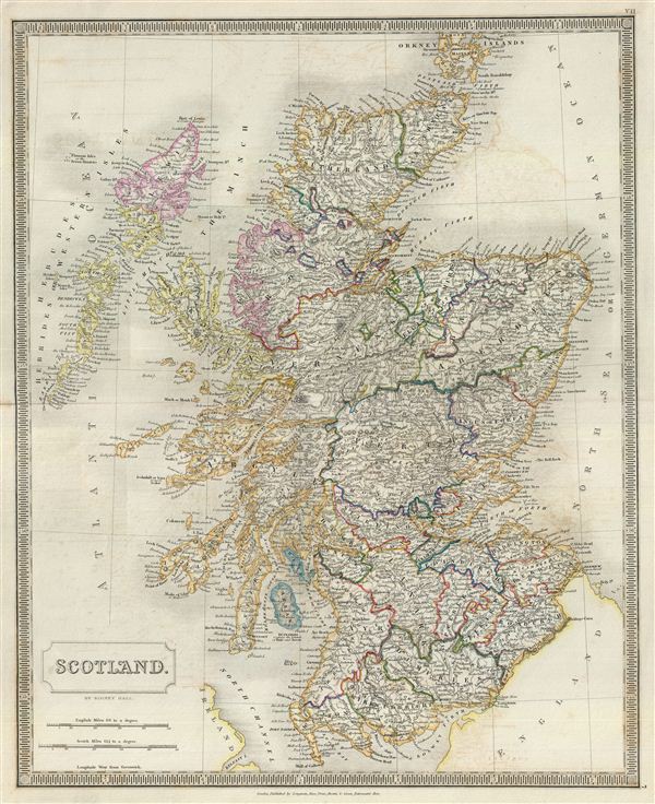
Scotland.
sold
- Digital Map Information
- Suitable for large format printing
- DPI: 300
- File Size: 14.55 MB
- File Type: ZIP / TIFF
- ICC color profile embedded
- Delivered instantly via download link
This is a beautiful map of Scotland from Sidney Hall's extremely scarce 1835 New General Atlas . It covers Scotland from the Orkney Islands to Wigton in the south inclusive of the Hebrides. Towns, rivers, mountains, railroads, battle ... (more details)

Ireland.
sold
- Digital Map Information
- Suitable for large format printing
- DPI: 300
- File Size: 15.44 MB
- File Type: ZIP / TIFF
- ICC color profile embedded
- Delivered instantly via download link
This is a beautiful map of Ireland from Sidney Hall's extremely scarce 1835 New General Atlas . It depicts the entire Emerald Isle including Northern Ireland, divided into 32 counties. It covers from Donegal in the north to Cork in ... (more details)
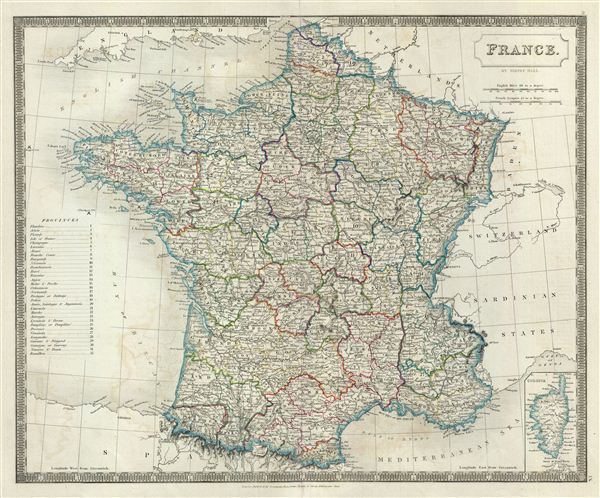
France.
sold
- Digital Map Information
- Suitable for large format printing
- DPI: 300
- File Size: 15.19 MB
- File Type: ZIP / TIFF
- ICC color profile embedded
- Delivered instantly via download link
This is a beautiful map of France from Sidney Hall's extremely scarce 1835 New General Atlas . It depicts the Kingdom of France showing all its various divisions according to province, covering from the Flanders in the north to ... (more details)

Russia.
sold
- Digital Map Information
- Suitable for large format printing
- DPI: 300
- File Size: 15.37 MB
- File Type: ZIP / TIFF
- ICC color profile embedded
- Delivered instantly via download link
This is a beautiful map of Russia from Sidney Hall's extremely scarce 1835 New General Atlas . It covers the European part of Russia from Poland to the Ural Mountains and from the Arctic Ocean to Circassia. It includes in ... (more details)

Prussia.
sold
- Digital Map Information
- Suitable for large format printing
- DPI: 300
- File Size: 12.96 MB
- File Type: ZIP / TIFF
- ICC color profile embedded
- Delivered instantly via download link
This is a beautiful map of Prussia from Sidney Hall's extremely scarce 1835 New General Atlas . Covering parts of the modern day nations of Poland, Lithuania and Germany, Prussia stretches across the map from Lower Rhine ... (more details)
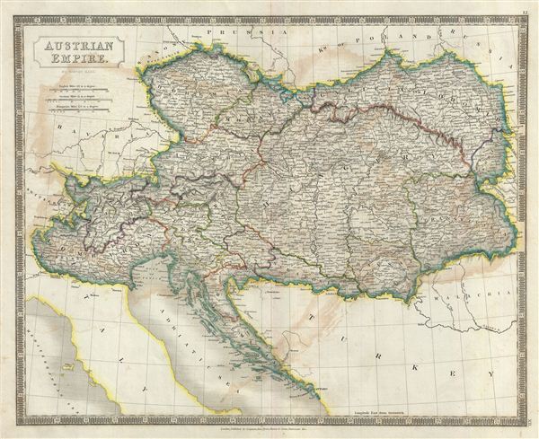
Austrian Empire.
sold
- Digital Map Information
- Suitable for large format printing
- DPI: 300
- File Size: 14.68 MB
- File Type: ZIP / TIFF
- ICC color profile embedded
- Delivered instantly via download link
This is a beautiful map of the Austrian Empire from Sidney Hall's extremely scarce 1835 New General Atlas . It covers the territories claimed by the once vast Austrian Empire, including in whole or part the modern day ... (more details)
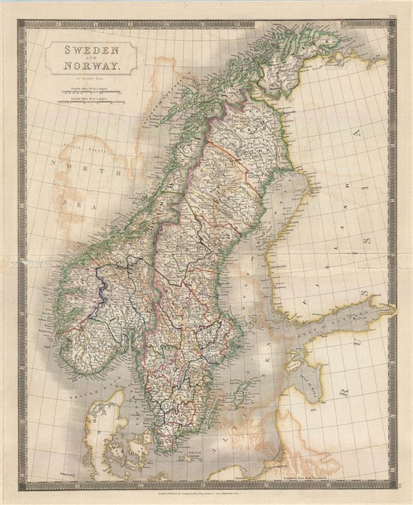
Sweden and Norway.
sold
- Digital Map Information
- Suitable for large format printing
- DPI: 300
- File Size: 17.08 MB
- File Type: ZIP / TIFF
- ICC color profile embedded
- Delivered instantly via download link
This is a beautiful map of Sweden and Norway from Sidney Hall's extremely scarce 1835 New General Atlas . It covers from the Arctic Sea south to Denmark and east as far as the Gulf of Finland. Towns, rivers, ... (more details)

Johnson's Indiana.
sold
- Digital Map Information
- Suitable for large format printing
- File Size: 16.83 MB
- File Type: ZIP / TIFF
- ICC color profile embedded
- Delivered instantly via download link
This is Johnson and Ward's 1865 map of Indiana. It covers Indiana in full as well as parts of the adjacent states. Various towns, cities, rivers and several other topographical features are noted with relief ... (more details)
Important map showing the early development of the Van Diemen's Land or Tasmania colony.
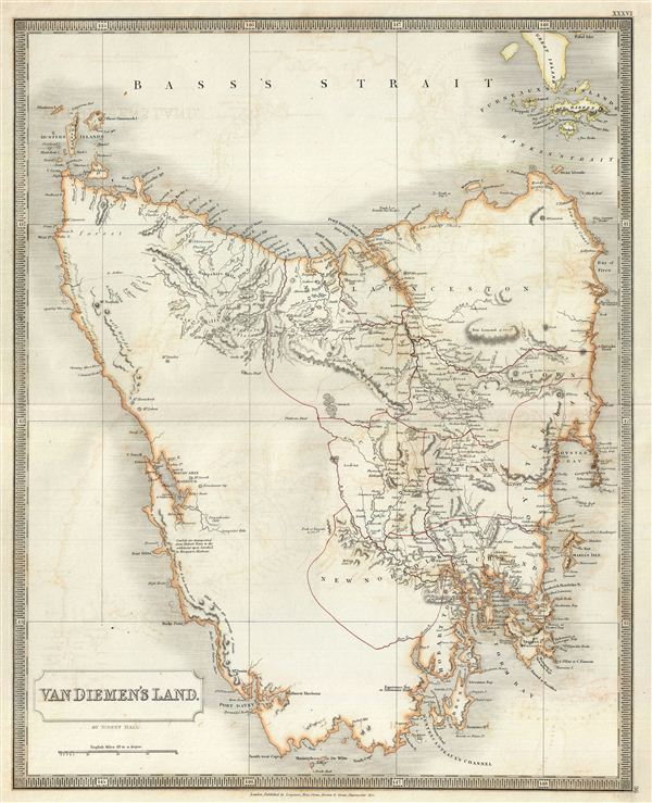
Van Diemen's Land.
sold
- Digital Map Information
- Suitable for large format printing
- DPI: 300
- File Size: 14.54 MB
- File Type: ZIP / TIFF
- ICC color profile embedded
- Delivered instantly via download link
A beautiful map of the colony of Tasmania or Van Diemen's Land, Australia, from Sidney Hall's extremely scarce 1835 New General Atlas . The map covers the entire island of Tasmania as well as nearby Flinders ... (more details)
Important map showing the development of the New South Wales colony.

Colony of New South Wales.
sold
- Digital Map Information
- Suitable for large format printing
- DPI: 300
- File Size: 15.07 MB
- File Type: ZIP / TIFF
- ICC color profile embedded
- Delivered instantly via download link
A beautiful map of the colony of New South Wales, Australia, from Sidney Hall's extremely scarce 1835 New General Atlas . The map covers eastern Australia from Moreton Bay south, Past Sydney and Botany Bay, ... (more details)
Important 18th century map of the Red Sea.
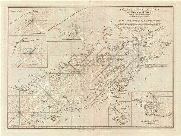
A Chart of the Red Sea from Moka to Geddah.
sold
- Digital Map Information
- Suitable for large format printing
- DPI: 300
- File Size: 21.12 MB
- File Type: ZIP / TIFF
- ICC color profile embedded
- Delivered instantly via download link
A fine example of Laurie and Whittle's 1794 nautical chart or maritime map of the southern half of the Red Sea, roughly from Mecca (Jeddah, Geddah), to the Bab el Mandeb Strait (Mocha, Yemen and Assab, ... (more details)
The earliest specific map of the Andaman Islands.
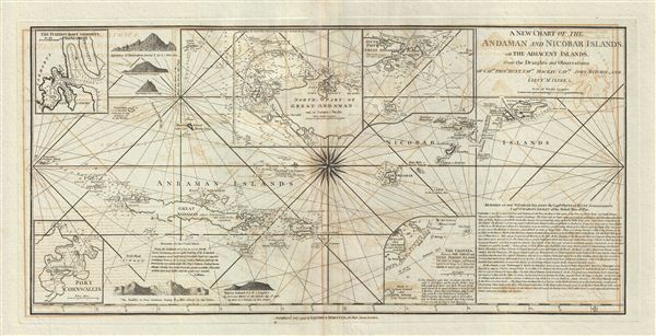
A New Chart of the Andaman and Nicobar Islands, with the Adjacent Islands, from the Draughts and Observations of Captn. Phins. Hunt, Captn. Mackay, Captn. John Ritchie, and Lieutt. Mc. Cluer, & c.
sold
- Digital Map Information
- Suitable for large format printing
- DPI: 300
- File Size: 6.67 MB
- File Type: ZIP / TIFF
- ICC color profile embedded
- Delivered instantly via download link
A very scarce and exceptionally fine example of Laurie and Whittle's 1798 nautical chart or maritime map of the Andaman and Nicobar Islands. The map covers from the Cocos Islands eastwards past Great ... (more details)
Scarce early nautical chart of Burma or Myanmar.
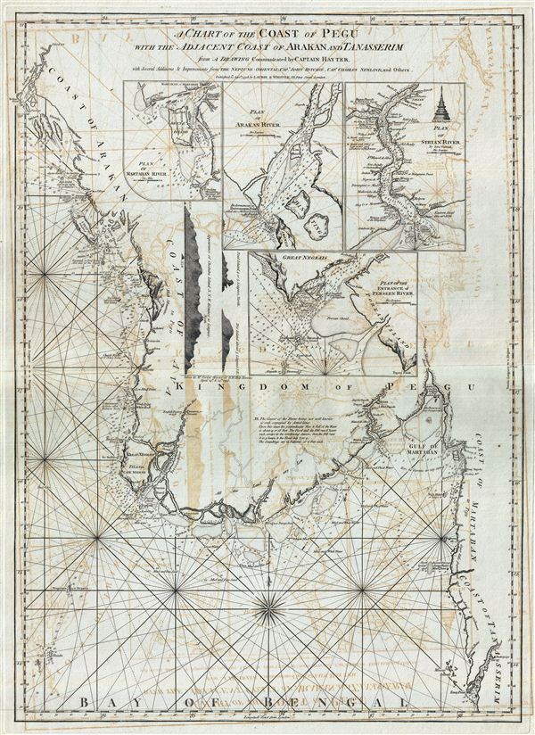
A Chart of the Coast of Pegu with the Adjacent Coast of Arakan and Tanasserim.
sold
- Digital Map Information
- Suitable for large format printing
- DPI: 300
- File Size: 29.01 MB
- File Type: ZIP / TIFF
- ICC color profile embedded
- Delivered instantly via download link
A fine example of Laurie and Whittle's 1798 nautical chart or maritime map of Burma, Myanmar, or as it was known in the 18th century, Pegu. The map covers the western extension of Southeast Asia from ... (more details)
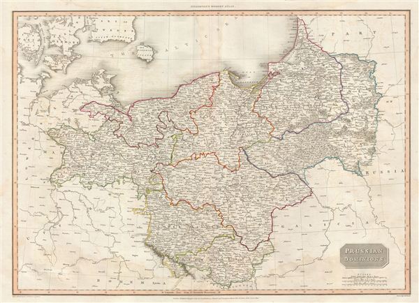
Prussian Dominions.
sold
- Digital Map Information
- Suitable for large format printing
- DPI: 300
- File Size: 18.27 MB
- File Type: ZIP / TIFF
- ICC color profile embedded
- Delivered instantly via download link
A scarce, beautiful, and exceptionally interesting example of John Pinkerton's stunning 1812 map of Prussia. The Map covers from the Baltic Sea to Upper Silesia and from Lowery Saxony to Russia, ... (more details)
A fascinating attempt to reconcile early explorations of the American West.

The World on Mercators Projection Western Part
sold
- Digital Map Information
- Suitable for large format printing
- DPI: 300
- File Size: 17.08 MB
- File Type: ZIP / TIFF
- ICC color profile embedded
- Delivered instantly via download link
A scarce, beautiful, and exceptionally interesting example of John Pinkerton's stunning 1812 map of North America and South America. The map covers all of North American, Central America, the ... (more details)

Philadelphia.
sold
- Digital Map Information
- Suitable for large format printing
- Full resolution TIFF file
- ICC color profile embedded
- Delivered instantly via download link
A fine example of Thomas Cowperthwait and S. A. Mitchell's 1850 map of the city of Philadelphia, Pennsylvania. The whole is engraved in Mitchell's distinctive style with green border work and ... (more details)