

Johnson's South America.
sold
- Digital Map Information
- Suitable for large format printing
- File Size: 16.97 MB
- File Type: ZIP / TIFF
- ICC color profile embedded
- Delivered instantly via download link
This is a beautiful example of Johnson and Ward's 1866 map of South America. It covers the entire continent from the Caribbean to Tierra del Fuego and from the Pacific to the Atlantic, including the Falkland and South Georgia island groups. Features the continent ... (more details)
The finest map of Cuba to appear in the 19th century.

Isla de Cuba.
sold
- Digital Map Information
- Suitable for large format printing
- DPI: 300
- File Size: 54.34 MB
- File Type: ZIP / TIFF
- ICC color profile embedded
- Delivered instantly via download link
A fine example of Francisco Coello de Portugal y Quesada's massive 1853 map of Cuba. Coello's map is the first scientifically produced Spanish map of Cuba and is presented on a previously unseen scale. The topography is the work of Camilo Alabern and the map was ... (more details)
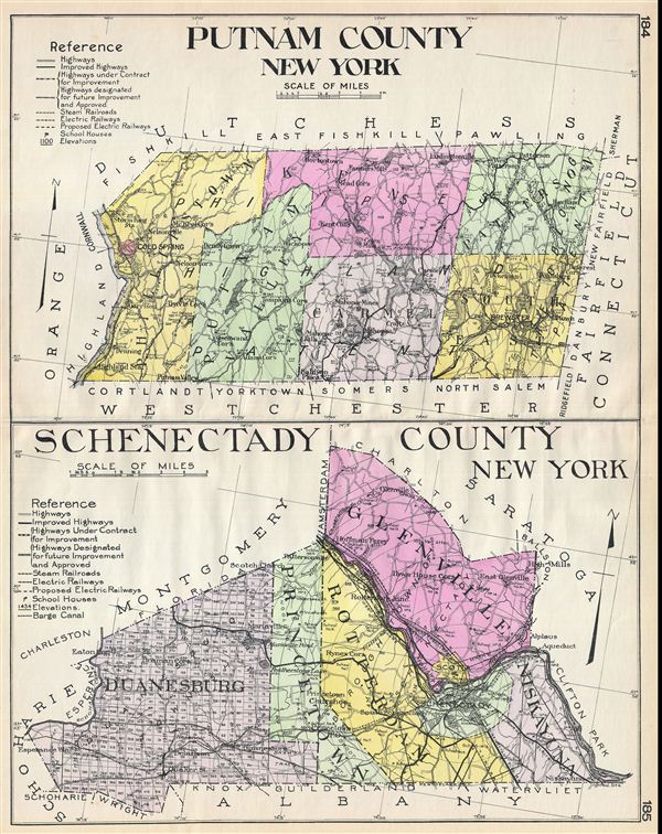
Putnam County New York. Schenectady County New York.
sold
- Digital Map Information
- Suitable for large format printing
- File Size: 23.8 MB
- File Type: ZIP / TIFF
- ICC color profile embedded
- Delivered instantly via download link
A highly appealing 1912 large format folio map of Putnam County and Schenectady County, New York, issued for the New Century Atlas of Counties of the State of New York . Essentially two maps on a single sheet. The upper map covers Putnam County the east side of ... (more details)
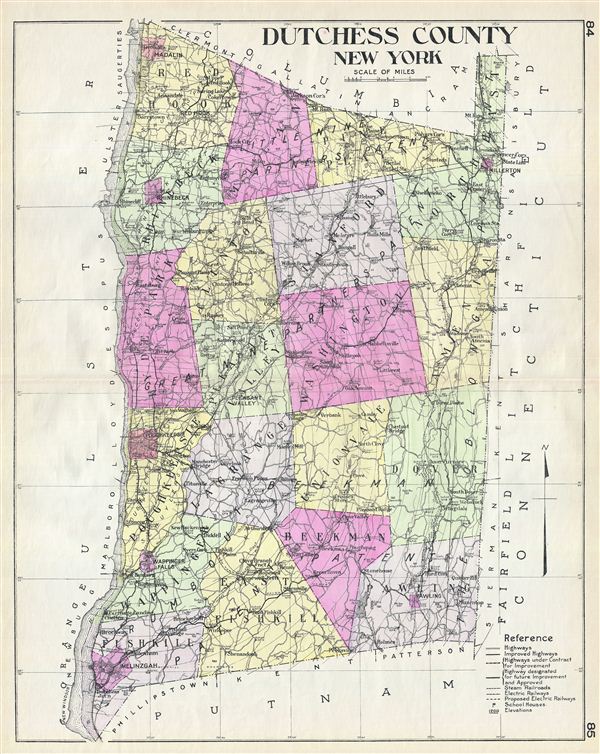
Dutchess County New York.
sold
- Digital Map Information
- Suitable for large format printing
- File Size: 23.88 MB
- File Type: ZIP / TIFF
- ICC color profile embedded
- Delivered instantly via download link
A highly appealing 1912 large format folio map of Dutchess County, issued for the New Century Atlas of Counties of the State of New York . The map covers the east side of the Hudson River from Fishkill to Red Hook, including the communities of Rhinebeck, Hyde ... (more details)

Boston Harbor.
sold
- Digital Map Information
- Suitable for large format printing
- File Size: 9 MB
- File Type: ZIP / TIFF
- ICC color profile embedded
- Delivered instantly via download link
An uncommon 1897 early example of a George H. Walker aquatint view of Boston Harbor. Centered on South Boston, the view covers Boston Harbor from East Boston and Nahant eastward as far as Squantum and Slate Island. The bustling harbor is shows full of ships ... (more details)

Bird's Eye View of Boston Harbor along the South Shore to Provincetown.
sold
- Digital Map Information
- Suitable for large format printing
- Full resolution TIFF file
- ICC color profile embedded
- Delivered instantly via download link
A remarkable 1918 color lithograph map and view of Boston Harbor from Boston to Provincetown. Includes all of Cape Cod Bay, Quincy Bay and Dorchester Bay with the communities of Boston, East Boston, South Boston, Dorchester, Quincy, Hough's Neck, Mingham, ... (more details)

Bird's-Eye View of Narraganset Bay.
sold
- Digital Map Information
- Suitable for large format printing
- File Size: 26.92 MB
- File Type: ZIP / TIFF
- ICC color profile embedded
- Delivered instantly via download link
An attractive and uncommon c. 1900 bird's eye view map of Narragansett Bay, Rhode Island, by the Boston map publisher George H. Walker. The view covers the entirety of Narragansett Bay from Point Judith to Providence, and extending eastwards as far as ... (more details)
Scarce nautical chart of the Inner Passage and pirate haven of Madagascar.
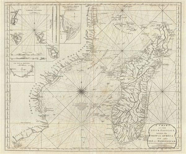
A Chart of the Inner Passage between the Coast of Africa and th Isle of Madagascar.
sold
- Digital Map Information
- Suitable for large format printing
- DPI: 300
- File Size: 26.97 MB
- File Type: ZIP / TIFF
- ICC color profile embedded
- Delivered instantly via download link
An extremely scarce 1797 nautical chart or maritime map of the inner passage between Madagascar and southeast Africa. The chart includes the coast of modern day Mozambique from Cape Delgado and the Comoros Islands southwards as far as modern day ... (more details)
Uncommon early European map of Beijing or Peking China.
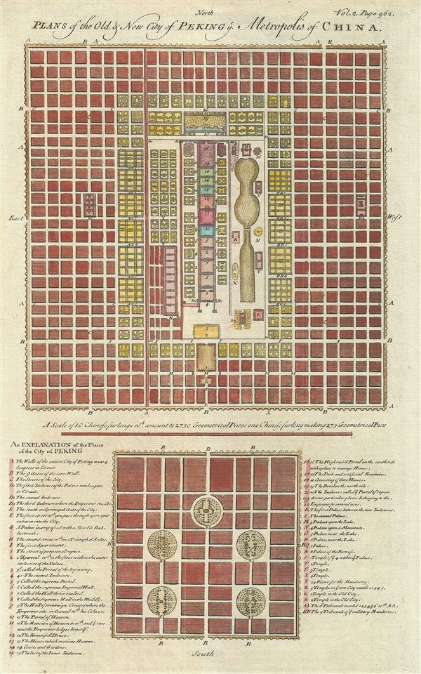
Plans of the Old & New City of Peking Metropolis of China.
sold
- Digital Map Information
- Suitable for large format printing
- DPI: 300
- File Size: 4.69 MB
- File Type: ZIP / TIFF
- ICC color profile embedded
- Delivered instantly via download link
An uncommon and appealing 1744 map of Beijing or Peking, China. The map features two maps of Beijing both drawn to scale. The larger upper map illustrates 'New Peking' c. 1700 while the smaller map shows ancient Beijing. Both maps feature numerous ... (more details)

Boston.
sold
- Digital Map Information
- Suitable for large format printing
- Full resolution TIFF file
- ICC color profile embedded
- Delivered instantly via download link
An extremely attractive panoramic view of Boston Harbor by J. Hill and Charles Mottram. The view reveals a busy harbor with ships of all nations and types plying the waters. In the foreground fisherman and dockworkers ply their trade. In the ... (more details)
One of the few maps to illustrate the Connecticut Western Reserve in modern day Ohio. Sovereignty over the District of Maine remains unresolved.
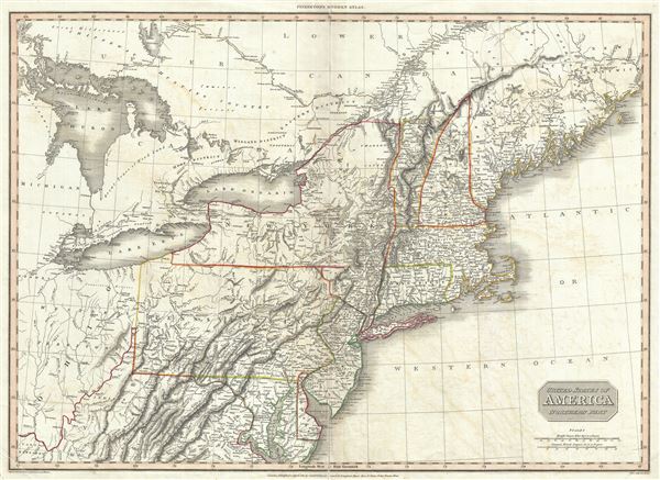
United States of America Northern Part.
sold
- Digital Map Information
- Suitable for large format printing
- DPI: 300
- File Size: 20.37 MB
- File Type: ZIP / TIFF
- ICC color profile embedded
- Delivered instantly via download link
A rare and important 1810 map of the northeastern part of the United States by John Pinkerton. The map covers from Lake Huron and Ohio, extending north as far as Canada and Maine, and south to the Chesapeake Bay and northern Kentucky. The ... (more details)
One of the most thorough treatments of this region prior to the U.S. government surveys.
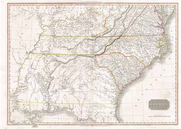
United States of America Southern Part.
sold
- Digital Map Information
- Suitable for large format printing
- DPI: 300
- File Size: 23.62 MB
- File Type: ZIP / TIFF
- ICC color profile embedded
- Delivered instantly via download link
A scarce and important 1809 map of the southeastern part of the United States by John Pinkerton. The map covers from the Mississippi River eastward to the Atlantic, extending north as far as Delaware, and south to northern Florida and the ... (more details)
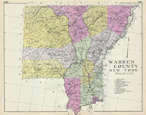
Warren County New York.
sold
- Digital Map Information
- Suitable for large format printing
- File Size: 23.75 MB
- File Type: ZIP / TIFF
- ICC color profile embedded
- Delivered instantly via download link
A highly appealing 1912 large format folio map of Warren County, New York issued for the New Century Atlas of Counties of the State of New York . The map covers this attractive Adirondack region from Hamilton to Lake George and from Essex ... (more details)

Nassau County New York.
sold
- Digital Map Information
- Suitable for large format printing
- File Size: 21.26 MB
- File Type: ZIP / TIFF
- ICC color profile embedded
- Delivered instantly via download link
A highly appealing 1912 large format folio map of Nassau County, Long Island, New York issued for the New Century Atlas of Counties of the State of New York . The map covers from Queens to Huntington and from the Long Island Sound to the ... (more details)
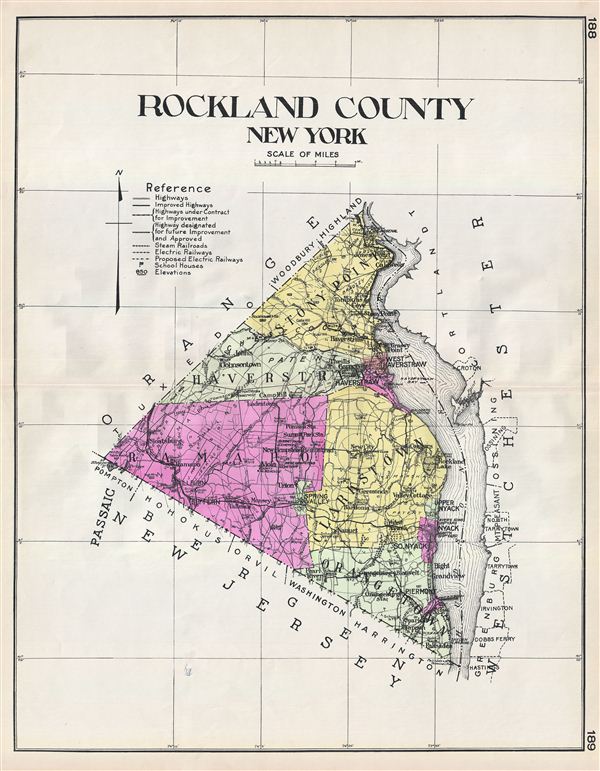
Rockland County New York.
sold
- Digital Map Information
- Suitable for large format printing
- File Size: 18.32 MB
- File Type: ZIP / TIFF
- ICC color profile embedded
- Delivered instantly via download link
A highly appealing 1912 large format folio map of Rockland County, issued for the New Century Atlas of Counties of the State of New York . The map covers the west side of the Hudson River from Palisades to Stony Point, including ... (more details)

Suffolk County New York.
sold
- Digital Map Information
- Suitable for large format printing
- File Size: 21.09 MB
- File Type: ZIP / TIFF
- ICC color profile embedded
- Delivered instantly via download link
A highly appealing 1912 large format folio map of Suffolk County, Long Island, New York issued for the New Century Atlas of Counties of the State of New York . The map covers from Oyster Bay to Montauk, including the Hamptons, ... (more details)

Greater New York City.
sold
- Digital Map Information
- Suitable for large format printing
- File Size: 22.33 MB
- File Type: ZIP / TIFF
- ICC color profile embedded
- Delivered instantly via download link
A highly appealing 1912 large format folio map of New York City issued for the New Century Atlas of Counties of the State of New York . The map covers from Westchester to Sandy Hook and from Paterson to Nassau County, ... (more details)

Artesia Comitatus Artois.
sold
- Digital Map Information
- Suitable for large format printing
- DPI: 300
- File Size: 13.2 MB
- File Type: ZIP / TIFF
- ICC color profile embedded
- Delivered instantly via download link
An attractive 1642 Joannes Janssonius (Jan Jansson) map of Artois or Artesia, France. Artois is former province located in the northwestern part of France, boarding Belgium (Flanders) on the north and Picardy to the ... (more details)
The earliest specific map of the Senakaku or Diaoyu Islands, currently the matter of a territorial dispute between China, Taiwan, and Japan.
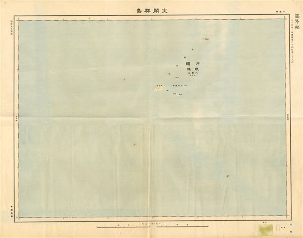
Senakaku or Diaoyu Islands
sold
- Digital Map Information
- Suitable for large format printing
- File Size: 1.53 MB
- File Type: ZIP / TIFF
- ICC color profile embedded
- Delivered instantly via download link
This is an extremely rare 1934 or Showa 9 Japanese map of the Senkaku or Diaoyutai, Diaoyu, Tiaoyutai or Pinnacle Islands. Currently the islands, located in the East China Sea, are a source of international tensions ... (more details)
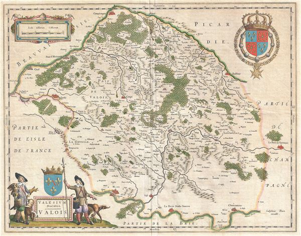
Valesium Ducatus. Valois.
sold
- Digital Map Information
- Suitable for large format printing
- DPI: 300
- File Size: 13.69 MB
- File Type: ZIP / TIFF
- ICC color profile embedded
- Delivered instantly via download link
A beautiful c. 1641 Johannes Blaeu map of Valois, France. This region, an ancient French Duchy, is located slightly northeast of Paris and includes the cities of Senlis, Compiegne, Crepy, Soissons, and Meaux. The ... (more details)