
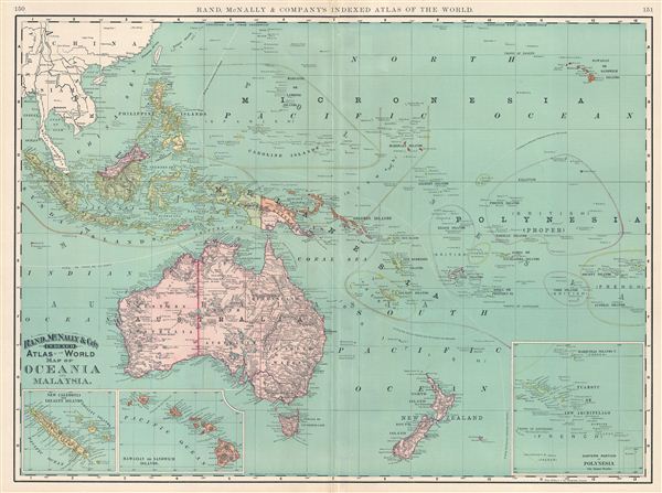
Map of Oceania and Malaysia.
sold
- Digital Map Information
- Suitable for large format printing
- File Size: 16.28 MB
- File Type: ZIP / TIFF
- ICC color profile embedded
- Delivered instantly via download link
This is a beautiful example of Rand McNally and Company's 1892 map of Oceania and Malaysia. It covers the Malay Archipelago, Micronesia, Melanesia, Polynesia and Australasia. Three insets along the lower border detail the New Caledonia and Loyalty Islands, the ... (more details)
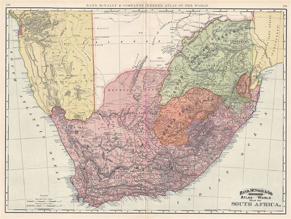
Map of South Africa.
sold
- Digital Map Information
- Suitable for large format printing
- File Size: 20.31 MB
- File Type: ZIP / TIFF
- ICC color profile embedded
- Delivered instantly via download link
This is a beautiful example of Rand McNally and Company 1892 map of South Africa. It covers the modern day countries of South Africa, Lesotho and Swaziland, along with parts of adjacent Mozambique, Namibia, and Botswana (Bechuanaland). After the discovery of ... (more details)

Map of Japan.
sold
- Digital Map Information
- Suitable for large format printing
- File Size: 21.72 MB
- File Type: ZIP / TIFF
- ICC color profile embedded
- Delivered instantly via download link
This is a beautiful example of Rand McNally and Company's 1892 map of Japan. Divided into two parts, the first focusing on the southern islands of Japan (here identified as Nippon), while the second details ezo (Yesso), that is northern Japan including ... (more details)
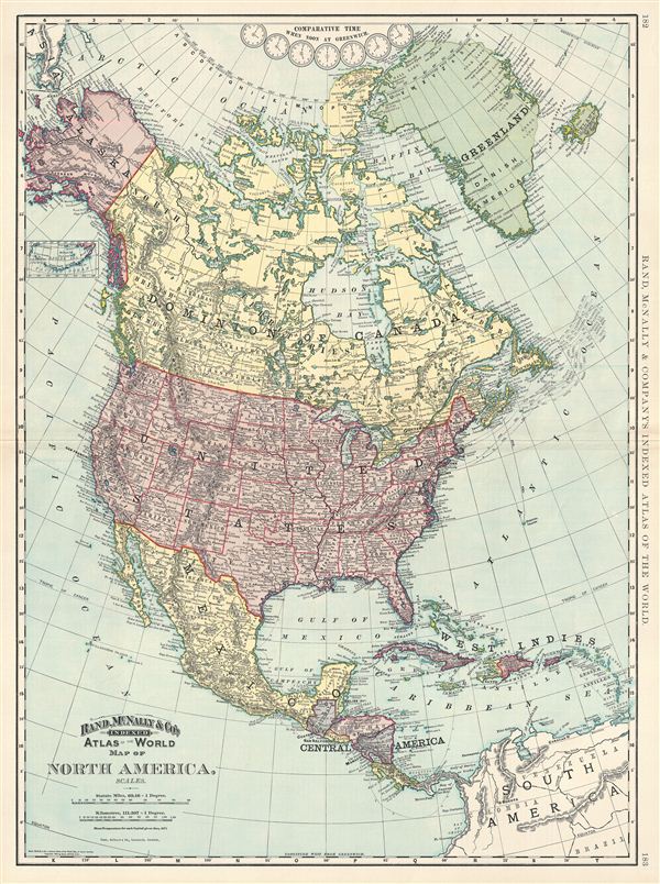
Map of North America.
sold
- Digital Map Information
- Suitable for large format printing
- File Size: 20.59 MB
- File Type: ZIP / TIFF
- ICC color profile embedded
- Delivered instantly via download link
This is a beautiful example of Rand McNally and Company's 1892 map of North America. Centered on the United States, it covers from the Arctic Ocean to Panama, including Greenland, Iceland and parts of South America and the West Indies. An inset near ... (more details)
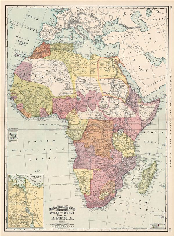
Map of Africa.
sold
- Digital Map Information
- Suitable for large format printing
- File Size: 22.3 MB
- File Type: ZIP / TIFF
- ICC color profile embedded
- Delivered instantly via download link
This is a beautiful example of Rand McNally and Company's 1892 map of Africa. It covers the entire continent from the Mediterranean Sea to the Cape of Good Hope, including the island of Madagascar. Parts of adjacent Arabia and europe are also ... (more details)
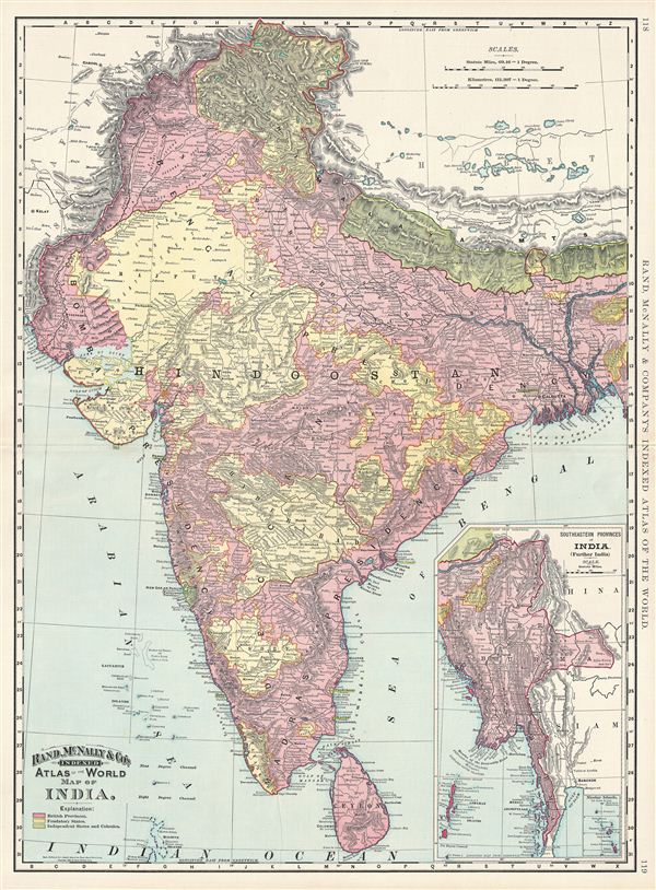
Map of India.
sold
- Digital Map Information
- Suitable for large format printing
- File Size: 22.02 MB
- File Type: ZIP / TIFF
- ICC color profile embedded
- Delivered instantly via download link
This is a beautiful example of Rand McNally and Company's 1892 map of India. It covers the entire subcontinent from Kashmir south to Ceylon (Sri Lanka) and from Sindh east to Assam. An inset in the lower right quadrant details the ... (more details)
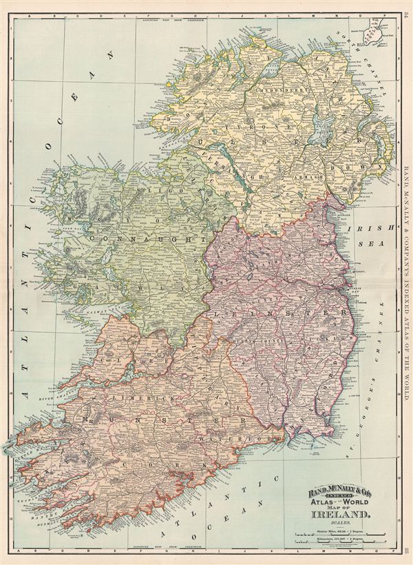
Map of Ireland.
sold
- Digital Map Information
- Suitable for large format printing
- File Size: 22.67 MB
- File Type: ZIP / TIFF
- ICC color profile embedded
- Delivered instantly via download link
This is a beautiful example of Rand McNally and Company's 1892 map of Ireland. The map covers the emerald Isle in full from Donegal to Cork. Ireland is divided into its four primary provinces, Munster, Ulster, Connaught and ... (more details)
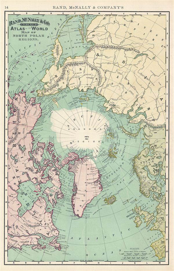
Map of North Polar Regions.
sold
- Digital Map Information
- Suitable for large format printing
- File Size: 9.05 MB
- File Type: ZIP / TIFF
- ICC color profile embedded
- Delivered instantly via download link
This is a beautiful example of Rand McNally and Company's 1892 map of the North Pole, Arctic, or Northern Polar Regions. It covers from ezo (Yesso or Hokkaido), Philadelphia, and Portugal north to the Pole. This map offers ... (more details)
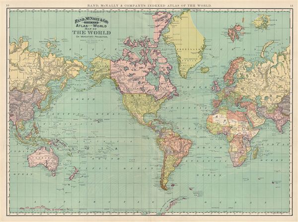
Map of The World on Mercator's Projection. Showing the Direction of the Ocean Currents.
sold
- Digital Map Information
- Suitable for large format printing
- File Size: 18.28 MB
- File Type: ZIP / TIFF
- ICC color profile embedded
- Delivered instantly via download link
This is a beautiful example of Rand McNally and Company's 1892 map of the World on Mercator's projection. Depicts the entire world centered on North and South America and offers a fascinating snapshot of the world during a ... (more details)
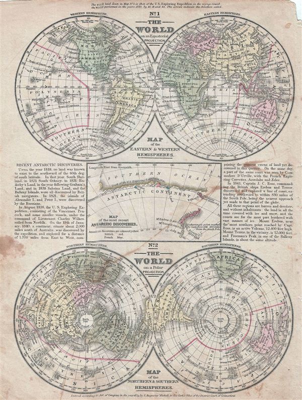
No. 1 The World on an Equatorial Projection. No. 2 The World on a Polar Projection. No. 3 Map of the most recent Antarctic Discoveries.
sold
- Digital Map Information
- Suitable for large format printing
- DPI: 300
- File Size: 4.59 MB
- File Type: ZIP / TIFF
- ICC color profile embedded
- Delivered instantly via download link
This is an example of Mitchell's 1839 map of the World in hemispheres. Divided into three separate maps, the first map details the world on an equatorial projection, covering the Western and eastern Hemispheres. The route ... (more details)

Johnson's Map of New York and the Adjacent Cities.
sold
- Digital Map Information
- Suitable for large format printing
- File Size: 21.4 MB
- File Type: ZIP / TIFF
- ICC color profile embedded
- Delivered instantly via download link
A fine hand colored map of New York City and Brooklyn dating to 1865. Covers the island of Manhattan and the borough of Brooklyn as well as parts of Jersey City and Hoboken. Johnson's plan is heavily based upon the third ... (more details)

Johnson's Delaware and Maryland.
sold
- Digital Map Information
- Suitable for large format printing
- File Size: 10.22 MB
- File Type: ZIP / TIFF
- ICC color profile embedded
- Delivered instantly via download link
This is a beautiful example of Johnson and Ward's 1865 map the Delaware and Maryland. It covers both states and shows parts of adjacent states. Includes a large inset map of the District of Columbia or Washington D.C. ... (more details)

Johnson's Wisconsin
sold
- Digital Map Information
- Suitable for large format printing
- File Size: 18.72 MB
- File Type: ZIP / TIFF
- ICC color profile embedded
- Delivered instantly via download link
This rare 1865 map offers a fascinating snapshot of Michigan and Wisconsin at the height of the American Civil War. Map shows both states in full with color coding according to county. excellent Great Lakes detail ... (more details)

Johnson's Vermont, New Hampshire, Massachusetts, Rhode Island, and Connecticut.
sold
- Digital Map Information
- Suitable for large format printing
- File Size: 15.4 MB
- File Type: ZIP / TIFF
- ICC color profile embedded
- Delivered instantly via download link
This is a beautiful example of Johnson and Ward's 1864 map of New england. The map covers the New england region from Long Island to Main and from the Hudson Valley to the Atlantic seaboard. Various towns, ... (more details)
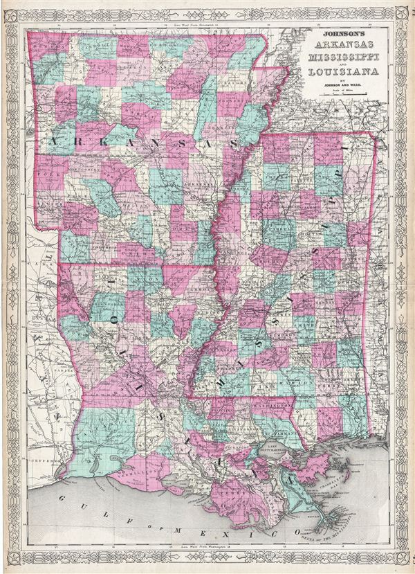
Johnson's Arkansas, Mississippi and Louisiana.
sold
- Digital Map Information
- Suitable for large format printing
- File Size: 23.16 MB
- File Type: ZIP / TIFF
- ICC color profile embedded
- Delivered instantly via download link
This is a beautiful example of Johnson and Ward's 1865 map of Arkansas, Mississippi and Louisiana. This rare map offers a fascinating snapshot of these secessionist states shortly following the outbreak of ... (more details)

Philadelphia and Vicinity Pennsylvania and New Jersey.
sold
- Digital Map Information
- Suitable for large format printing
- File Size: 55.15 MB
- File Type: ZIP / TIFF
- ICC color profile embedded
- Delivered instantly via download link
A scarce and attractive 1896 U.S. Geological Survey Map of Philadelphia and Vicinity. Centered on metropolitan Philadelphia, the map covers from Frederick, PA, to Washington< New Jersey, and from ... (more details)
The first published representation of the 1668 Nicolls Map of Manhattan.

The Nicolls Map.
sold
- Digital Map Information
- Suitable for large format printing
- File Size: 27.14 MB
- File Type: ZIP / TIFF
- ICC color profile embedded
- Delivered instantly via download link
An attractive example of D. T. Valentine and George Hayward's 1863 reissue of the 1668 Nichols Plan or Map of Manhattan and New York City. When the English conquered New Amsterdam in 1664, they were ill equipped to administer their new colony - renamed New York after James, the Duke of York. English New York's first governor, Richard Nicolls, commissioned the first reasonably accurate survey of Manhattan and New York. The survey covers from the northernmost tip of Manhattan to Staten Island and incorporates parts of Long Island, modern day Westchester, and New Jersey. (more details)

Map of New York City Showing Portions of Brooklyn, Jersey City, and Westchester Co.
sold
- Digital Map Information
- Suitable for large format printing
- File Size: 23.11 MB
- File Type: ZIP / TIFF
- ICC color profile embedded
- Delivered instantly via download link
An uncommon 1892 Map of New York City by Rand McNally and Company. The map covers all of Manhattan and the Bronx as well as parts of Brooklyn, Queens, and Westchester. An inset in the lower ... (more details)
By far the rarest of the great early maps of Hawaii.

КАРТА САНДВЙЧЕВЫХЪ ОСТРВОВЪ 1826 [Map Sandvychevyh Ostrovov 1828] (Map of the Sandwich Islands 1826)
sold
- Digital Map Information
- Suitable for large format printing
- Full resolution TIFF file
- ICC color profile embedded
- Delivered instantly via download link
Perhaps the rarest of all the great early maps of the Hawaiian Islands, this is the Russian language first edition of Admiral Adam Johann von Krusenstern's important map of the Sandwich ... (more details)
A hand drawn manuscript map - most likely the first accurate nautical chart of west Sumatra's Pepper Coast.
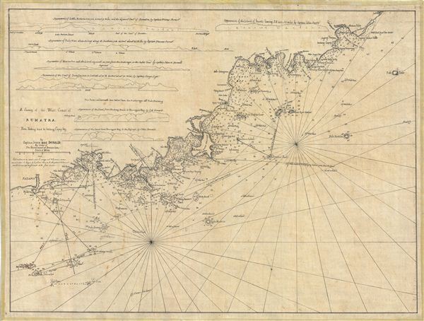
A Survey of the West Coast of Sumatra From Padang head to batang Capay Bay.
sold
- Digital Map Information
- Suitable for large format printing
- DPI: 300
- File Size: 13.45 MB
- File Type: ZIP / TIFF
- ICC color profile embedded
- Delivered instantly via download link
A remarkable discovery, this is a c. 1820 manuscript map of the western coasts of Sumatra (Indonesia) around the city of Pedang by Scottish sea captain John MacDonald. The map covers ... (more details)