
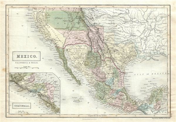
Mexico, California & Texas.
sold
- Digital Map Information
- Suitable for large format printing
- DPI: 300
- File Size: 6.25 MB
- File Type: ZIP / TIFF
- ICC color profile embedded
- Delivered instantly via download link
This is a fine example of the 1851 Black Map of Mexico, California and Texas. It covers from the southern border of Oregon as far south as Guatemala including New Mexico (with modern day Arizona), Utah (with modern day Nevada), and California. An inset map on the ... (more details)
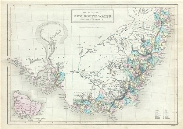
Part of Australia comprising the settled portions of New South Wales and South Australia.
sold
- Digital Map Information
- Suitable for large format printing
- DPI: 300
- File Size: 7 MB
- File Type: ZIP / TIFF
- ICC color profile embedded
- Delivered instantly via download link
This is a fine example of the 1851 Black Map of South Australia, New South Wales and Victoria, Australia. It covers the settled areas of New South Wales and South Australia. Victoria, which became an independent colony separate from New South Wales only in July ... (more details)

New Zealand.
sold
- Digital Map Information
- Suitable for large format printing
- DPI: 300
- File Size: 7.46 MB
- File Type: ZIP / TIFF
- ICC color profile embedded
- Delivered instantly via download link
This is a fine example of the 1851 Black Map of New Zealand. Various cities, towns, rivers, mountains, bays and several other topographical details are noted with relief shown by hachures. This map was engraved by William Hughes and issued the 1851 edition of ... (more details)
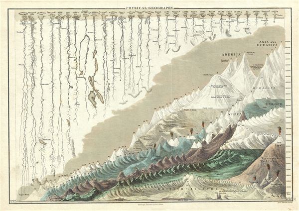
Physical Geography.
sold
- Digital Map Information
- Suitable for large format printing
- DPI: 300
- File Size: 7.22 MB
- File Type: ZIP / TIFF
- ICC color profile embedded
- Delivered instantly via download link
This is a fine example of Adam and Charles Black's 1851 comparative mountains and rivers of the world chart. Charts of this type were first introduced in england around 1823 and became a common feature in atlases throughout the 19th century. The present ... (more details)
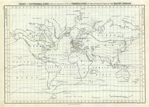
Chart of Isothermal Lines, Shewing the Mean Annual Temperature of the Different Parts of the Earth's Surface.
sold
- Digital Map Information
- Suitable for large format printing
- DPI: 300
- File Size: 7.23 MB
- File Type: ZIP / TIFF
- ICC color profile embedded
- Delivered instantly via download link
This is a fine example of Adam and Charles Black's 1851 map or chart of the World's isothermal lines showing the mean annual temperatures in the different parts of the earth's surface. The continents are named while countries are unmarked. The Arctic ... (more details)

The World, on Mercator's Projection.
sold
- Digital Map Information
- Suitable for large format printing
- Full resolution TIFF file
- ICC color profile embedded
- Delivered instantly via download link
This is a fine example of Adam and Charles Black's 1851 map of the world on Mercator's Projection. An interesting map of the world issued just as most of the earth's non-polar shore has been explored. Vast stretches of unmapped territory and ... (more details)

The World.
sold
- Digital Map Information
- Suitable for large format printing
- DPI: 300
- File Size: 6.38 MB
- File Type: ZIP / TIFF
- ICC color profile embedded
- Delivered instantly via download link
This is a fine example of Adam and Charles Black's 1851 map of the World in two hemispheres. Both the Western and eastern Hemispheres are drawn and offer a fascinating snapshot of the world during a period of rapid globalization and ... (more details)
The important first plan of New York City's Central Park - predates Olmstead and Vaux.
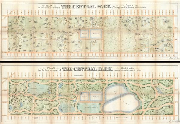
Map of the Lands Included in The Central Park, from a Topographical Survey, June 17th 1856. Plan for the Improvement of The Central Park, Adopted by the Commissioners, June 3rd 1856.
sold
- Digital Map Information
- Suitable for large format printing
- File Size: 40.96 MB
- File Type: ZIP / TIFF
- ICC color profile embedded
- Delivered instantly via download link
Two extremely rare 1856 pre-Design Competition plans of Central Park drawn by the park project's first engineer-in-Chief egbert Ludovicus Viele. Both plans extend from 59th street to 106th street, taking in the original grounds ... (more details)
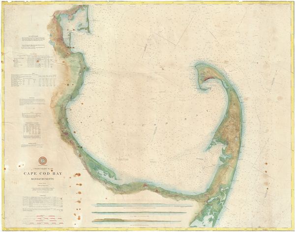
Coast Chart No. 110 Cape Cod Bay Massachusetts.
sold
- Digital Map Information
- Suitable for large format printing
- File Size: 41.79 MB
- File Type: ZIP / TIFF
- ICC color profile embedded
- Delivered instantly via download link
An attractive large format 1892 U.S. Coast Survey nautical chart or maritime map of Cape Cod Bay. The chart follows the Massachusetts coastline from Duxbury Bay to Provincetown at the tip of Cape Cod and south as far as ... (more details)

Regnum Borussiae Gloriosis auspicys Serenissimi et Potentissimi Prin Friderich III.
sold
- Digital Map Information
- Suitable for large format printing
- DPI: 300
- File Size: 20.59 MB
- File Type: ZIP / TIFF
- ICC color profile embedded
- Delivered instantly via download link
A stunning c. 1710 map of the Baltic coast consisting of northern Poland (Borussiae), Konigsburg (Kaliningrad), and parts of Lithuania, by the Nurmburg cartographer J. B. Homann. The map covers from German Pomerania ... (more details)

The Cunard Royal Mail Steamship 'Brittania' (John Hewitt, Commander.)
sold
- Digital Map Information
- Suitable for large format printing
- File Size: 14.51 MB
- File Type: ZIP / TIFF
- ICC color profile embedded
- Delivered instantly via download link
A fine 1876 view of Boston Harbor published by Ferdinand Meyer. This view, centered on the Royal Mail Steamship RMS Britannia , commemorates the exceptionally cold winter of 1844. By February of that year Boston ... (more details)
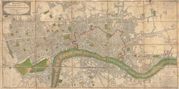
Wallis's Plan of the Cities of London and Westminster.
sold
- Digital Map Information
- Suitable for large format printing
- Full resolution TIFF file
- ICC color profile embedded
- Delivered instantly via download link
An attractive example of John Wallis's 1802 map of London and Westminster. The map covers from Hyde Park eastward along the Thames River to White Horse Street and Stepney, and from Pentonville in the north to St. ... (more details)
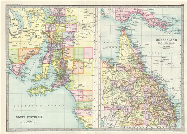
South Australia. Queensland and British New Guinea.
$75.00
Acquire
- Digital Map Information
- Suitable for large format printing
- File Size: 8.53 MB
- File Type: ZIP / TIFF
- ICC color profile embedded
- Delivered instantly via download link
This is a fine example of Bartholomew's 1890 map of South Australia and Queensland in Australia. The map is divided into two parts, with the map on the left featuring the southern part of the Australian state of ... (more details)
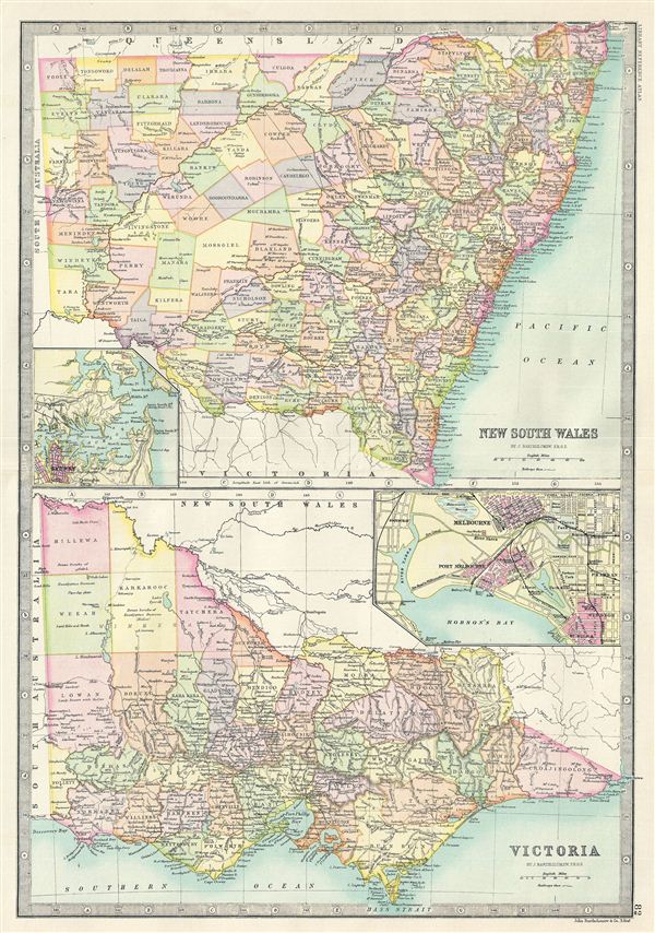
New South Wales. Victoria.
sold
- Digital Map Information
- Suitable for large format printing
- File Size: 8.74 MB
- File Type: ZIP / TIFF
- ICC color profile embedded
- Delivered instantly via download link
This is a fine example of Bartholomew's 1890 map of New South Wales and Victoria in Australia. The map is divided into two parts, with the upper map featuring the Australian state of New South Wales and the map ... (more details)
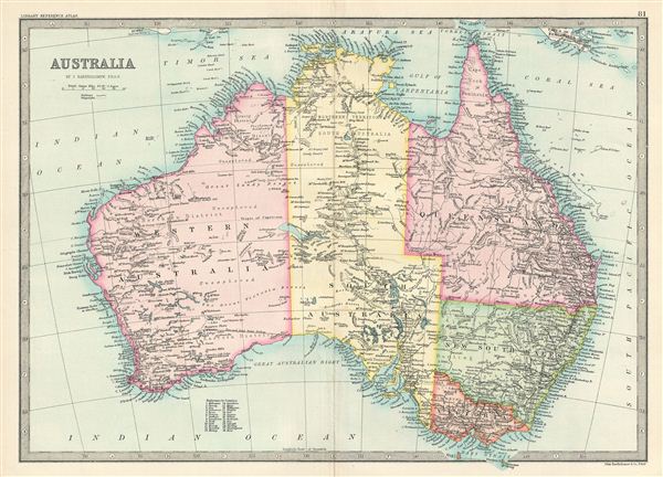
Australia.
sold
- Digital Map Information
- Suitable for large format printing
- File Size: 7.01 MB
- File Type: ZIP / TIFF
- ICC color profile embedded
- Delivered instantly via download link
This is a fine example of Bartholomew's 1890 map of Australia. It covers the entire continent from the Torres Strait south as far as the Bass Strait. Australia, divided into its five provinces of Western ... (more details)
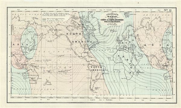
Johnson's World, Showing the Lines of Equal Magnetic Declination.
sold
- Digital Map Information
- Suitable for large format printing
- File Size: 2.28 MB
- File Type: ZIP / TIFF
- ICC color profile embedded
- Delivered instantly via download link
This is a beautiful example of Johnson's 1858 map or chart of the world's magnetic curves of equal variation. The chart depicts the magnetic curves over the entire world including the isomagnetic lines ... (more details)

Solar System.
sold
- Digital Map Information
- Suitable for large format printing
- DPI: 300
- File Size: 2.94 MB
- File Type: ZIP / TIFF
- ICC color profile embedded
- Delivered instantly via download link
This is a fine example of W. Lowery's c. 1840 Lowry map of the Solar System. The map shows the orbit of the primary planets transferred to the plane of the ecliptic with the place of aphelion. The ... (more details)
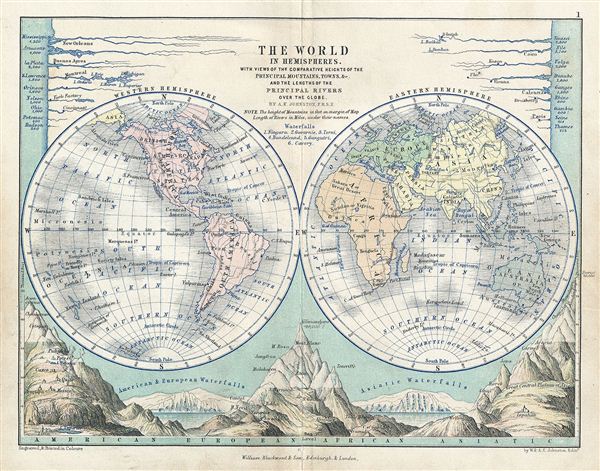
The World in Hemispheres.
sold
- Digital Map Information
- Suitable for large format printing
- DPI: 300
- File Size: 2.99 MB
- File Type: ZIP / TIFF
- ICC color profile embedded
- Delivered instantly via download link
This is a fine example of Blackwood's 1852 map of the world in hemispheres. It depicts the Western and eastern Hemispheres with countries named, but their borders not depicted. The bottom portion ... (more details)
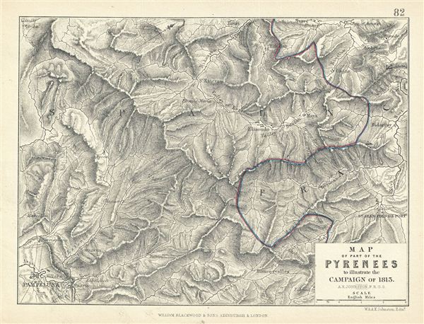
Map of Part of the Pyrenees to illustrate the Campaign of 1813.
sold
- Digital Map Information
- Suitable for large format printing
- DPI: 300
- File Size: 3.19 MB
- File Type: ZIP / TIFF
- ICC color profile embedded
- Delivered instantly via download link
This is a fine example of Blackwood's 1852 map showing part of the Pyrenees Mountain ranges illustrating the campaign of 1813. The boundary line between France and Spain is hand colored in blue ... (more details)
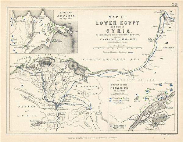
Map of Lower Egypt and Part of Syria. To Illustrate the Expedition to Egypt, and the Campaign of 1798-1801.
sold
- Digital Map Information
- Suitable for large format printing
- DPI: 300
- File Size: 1.71 MB
- File Type: ZIP / TIFF
- ICC color profile embedded
- Delivered instantly via download link
This is a fine example of Blackwood's 1852 map of Lower egypt and parts of Israel / Palestine (here labeled Syria). It covers the northern parts of egypt and the Nile Delta from the ... (more details)