
A fine overview of Antarctic Exploration in the middle part of the 19th century.

Southern Regions.
sold
- Digital Map Information
- Suitable for large format printing
- File Size: 8.44 MB
- File Type: ZIP / TIFF
- ICC color profile embedded
- Delivered instantly via download link
An excellent 1855 first edition example of Colton's map of the South Pole, Antarctica, or the Southern Polar Regions. Colton's map offers an excellent overview of the state Antarctic exploration and discovery around 1855. The southern continent is mapped only ... (more details)
A fine overview of Arctic Exploration in the middle part of the 19th century.

Northern Regions.
sold
- Digital Map Information
- Suitable for large format printing
- File Size: 9.25 MB
- File Type: ZIP / TIFF
- ICC color profile embedded
- Delivered instantly via download link
An excellent 1855 first edition example of Colton's map of the North Pole or Arctic. Covers from Lake Baikal, the Hudson Bay, the British Isles and Kamchatka north to the Pole. This is a historically ephemeral map as the Polar Regions were, as Colton drafted ... (more details)
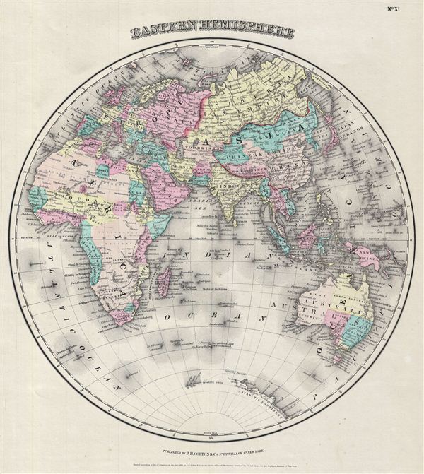
Eastern Hemisphere.
sold
- Digital Map Information
- Suitable for large format printing
- File Size: 3.04 MB
- File Type: ZIP / TIFF
- ICC color profile embedded
- Delivered instantly via download link
An excellent 1855 first edition example of Colton's map of the eastern Hemisphere. Offering a fascinating snapshot of the world during a period of rapid globalization and discovery, this map includes the entirety of Asia, europe and Africa as well as ... (more details)

Western Hemisphere.
sold
- Digital Map Information
- Suitable for large format printing
- File Size: 2.91 MB
- File Type: ZIP / TIFF
- ICC color profile embedded
- Delivered instantly via download link
An excellent 1855 first edition example of Colton's map of the Western Hemisphere. Offering a fascinating snapshot of the world during a period of rapid globalization and discovery, this map includes North America, South America and most of ... (more details)
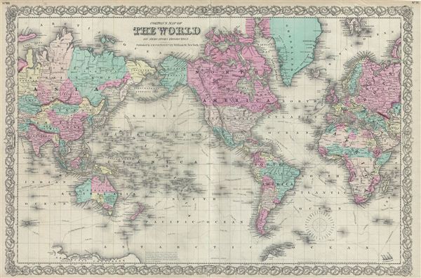
Colton's Map of The World on Mercator's Projection.
sold
- Digital Map Information
- Suitable for large format printing
- File Size: 20.88 MB
- File Type: ZIP / TIFF
- ICC color profile embedded
- Delivered instantly via download link
An excellent 1855 first edition example of Colton's map of the World on a Mercator's Projection. This map is a reduction and re-engraving of Colton's important 1848 wall map of the world. Colton offers a fascinating snapshot of the world ... (more details)

Map of The World Illustrating The Principal Features Of Meteorology. Map of The World Showing the Distribution And Limits of Cultivation of The Principal Plants Useful to Mankind.
sold
- Digital Map Information
- Suitable for large format printing
- File Size: 7.53 MB
- File Type: ZIP / TIFF
- ICC color profile embedded
- Delivered instantly via download link
A beautiful 1855 first edition example of Colton's map of the World's principal plants and features of meteorology. The map is divided into two parts. The upper map illustrates the principal features of meteorology across the world. The ... (more details)

Map of The World Illustrating the principal features of The Land and The Co-Tidal Lines. Map of The World Showing the principal Ocean Currents & Boundaries of River Systems.
sold
- Digital Map Information
- Suitable for large format printing
- File Size: 5.52 MB
- File Type: ZIP / TIFF
- ICC color profile embedded
- Delivered instantly via download link
A beautiful 1855 first edition example of Colton's map of land features and ocean currents. The map is divided into two parts. The upper map depicts the principle features of land, and the co-tidal lines. Colors coded according to ... (more details)

Comparative Size of Lakes and Islands.
sold
- Digital Map Information
- Suitable for large format printing
- File Size: 9.3 MB
- File Type: ZIP / TIFF
- ICC color profile embedded
- Delivered instantly via download link
A beautiful 1855 first edition example of Colton's curious topical chart of the world's great islands and lakes. The chart is divided into lakes and islands of the eastern and Western Hemispheres. Curiously does not include ... (more details)

Mountains & Rivers.
sold
- Digital Map Information
- Suitable for large format printing
- File Size: 15.26 MB
- File Type: ZIP / TIFF
- ICC color profile embedded
- Delivered instantly via download link
An excellent 1855 first edition example of Colton's Mountains and Rivers chart. Most likely the finest American Mountains and Rivers chart or map of the mid-19th century. This is the 1855 Colton prototype for the popular ... (more details)
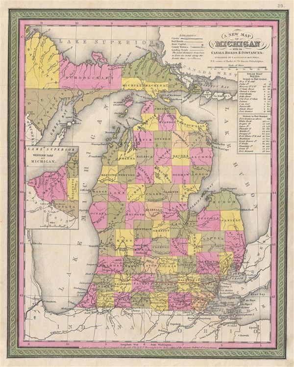
A New Map of Michigan with its Canals, Roads & Distances.
sold
- Digital Map Information
- Suitable for large format printing
- DPI: 300
- File Size: 9.11 MB
- File Type: ZIP / TIFF
- ICC color profile embedded
- Delivered instantly via download link
A fine example of the 1846 first edition of Mitchell's map of Michigan. The whole is engraved and colored in Mitchell's distinctive style with green border work and vivid pastels. Political and topographical features are ... (more details)
Early Japanese woodblock map of China showing Great Wall.
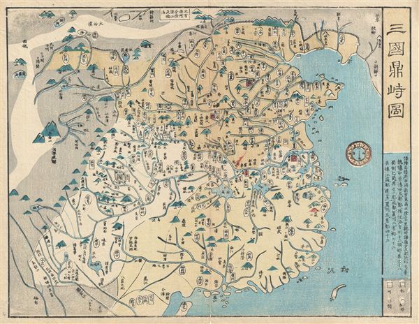
China.
sold
- Digital Map Information
- Suitable for large format printing
- DPI: 300
- File Size: 5.11 MB
- File Type: ZIP / TIFF
- ICC color profile embedded
- Delivered instantly via download link
A rare and appealing c. 1820 Japanese woodblock map of China. The map covers all China from the Great Wall to Hainan. Names numerous cities, provinces, and rivers. Topography rendered in profile. Beijing and Shanghai ... (more details)
Magnificent decorative map of the Holy Land showing the Exodus.

Perigrinatie ofte Veertich-Iarige Reyse der Kinderen Israels
sold
- Digital Map Information
- Suitable for large format printing
- DPI: 300
- File Size: 10.35 MB
- File Type: ZIP / TIFF
- ICC color profile embedded
- Delivered instantly via download link
An absolutely stunning 1702 map of the Holy Land, Israel, or Palestine by N. Visscher and D. Stoopendaal. This map, from Keur's important Dutch Bible of 1702, is oriented to west and covers from the Nile Delta, Cairo ... (more details)
The Bufflao Map.

Amplissimae Regionis Mississipi seu Provinciae Ludovicianae a R.P. Ludovico Hennepin Francisc Miss in America Septentrionali Anno 1687. Detectae, Nunc Gallorum Coloniis et Actionum Negotiis Toto Orbe Celeberrimae.
sold
- Digital Map Information
- Suitable for large format printing
- DPI: 300
- File Size: 20.99 MB
- File Type: ZIP / TIFF
- ICC color profile embedded
- Delivered instantly via download link
An iconic c. 1720 map of the Mississippi River Valley by Johann Baptiste Homann. Commonly called the 'Buffalo Map' for its distinctive decorative elements depicting a stylized buffalo, this map is derived from an earlier 1718 map of the same region by G. De L'Isle, although it has been enlarged to include New England. (more details)
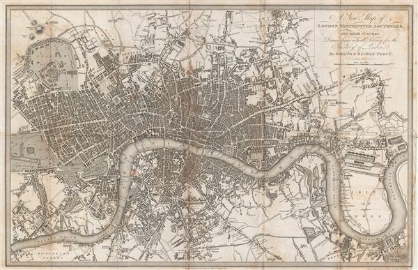
A New Map of London, Westminster, Southwark, and their suburbs.
sold
- Digital Map Information
- Suitable for large format printing
- DPI: 300
- File Size: 6.99 MB
- File Type: ZIP / TIFF
- ICC color profile embedded
- Delivered instantly via download link
An uncommon 1823 map of London, england, by Benjamin Davies. Centered on the Thames River, this map covers London from Chelsea to the east India Docks and from Regents Park to Greenwich Park. The map identifies all ... (more details)
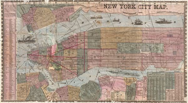
New York City Map.
sold
- Digital Map Information
- Suitable for large format printing
- File Size: 17.53 MB
- File Type: ZIP / TIFF
- ICC color profile embedded
- Delivered instantly via download link
An uncommon and colorful 1857 map of New York City by Humphrey Phelps. The map covers Manhattan south of 131st street as well as adjacent parts of Brooklyn, Queens, Hoboken, and Jersey City. Individual streets are ... (more details)
Florida on the cusp of the Second Seminole War.

Map of Florida according to the Latest Authorities. Comparative Elevation of thePrincipal Mountas Cities & C. in North and South America.
sold
- Digital Map Information
- Suitable for large format printing
- DPI: 300
- File Size: 6.58 MB
- File Type: ZIP / TIFF
- ICC color profile embedded
- Delivered instantly via download link
An extremely rare map of Florida issued by A. Finley in his 1826 New American Atlas . The map depicts territorial Florida just five years after the region was annexed by the United States. Color coding defines ... (more details)
Reflects the curious Ptolemaic convention of a landlocked Indian Ocean.
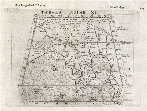
Tabula Asiae XI.
sold
- Digital Map Information
- Suitable for large format printing
- DPI: 300
- File Size: 3.45 MB
- File Type: ZIP / TIFF
- ICC color profile embedded
- Delivered instantly via download link
This is an uncommon 1588 Ptolemaic map of Southeast Asia and the Malay Peninsula issued for Girolamo Ruscelli's Italian edition of the Geografia di Tolomeo . Cartographically Ruscelli based this map on ... (more details)

Johnson's Georgia and Alabama.
sold
- Digital Map Information
- Suitable for large format printing
- File Size: 19.27 MB
- File Type: ZIP / TIFF
- ICC color profile embedded
- Delivered instantly via download link
This is a beautiful example of Johnson and Ward's 1863 map of Georgia and Alabama. Offers a fascinating snapshot of these Confederate states during the American Civil War. The map shows both states in ... (more details)
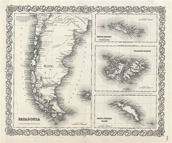
Patagonia. South Georgia Island. South Orkney or Powell's Group. Falkland Islands.
sold
- Digital Map Information
- Suitable for large format printing
- File Size: 8.7 MB
- File Type: ZIP / TIFF
- ICC color profile embedded
- Delivered instantly via download link
An excellent 1855 first edition example of Colton's rare map of Patagonia, the Falkland Islands, South Georgia Islands, and the Powell Group. The whole is divided into four maps. Left hand map covers ... (more details)

Argentine Republic, Chili, Uruguay and Paraguay.
sold
- Digital Map Information
- Suitable for large format printing
- File Size: 10.84 MB
- File Type: ZIP / TIFF
- ICC color profile embedded
- Delivered instantly via download link
An excellent 1855 first edition example of Colton's map of Chile, Argentina, Paraguay and Uruguay. This map covers from Bolivia to Patagonia and from the Pacific to the Atlantic. Colton notes ... (more details)