

Nord America zur Ubersicht der Entdeckung, Eroberung und Colonisation.
sold
- Digital Map Information
- Suitable for large format printing
- File Size: 6.97 MB
- File Type: ZIP / TIFF
- ICC color profile embedded
- Delivered instantly via download link
This is Karl von Spruner's 1855 map of North America, with an overview of its 'discovery, conquest and colonization.' Nation states, European possessions, and overlapping indigenous peoples' territories are named and color coded, with historical notes appearing ... (more details)
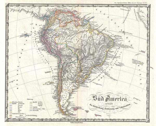
Sud America zur Ubersicht der Entdeckung, Eroberung und Colonisation.
sold
- Digital Map Information
- Suitable for large format printing
- File Size: 4.76 MB
- File Type: ZIP / TIFF
- ICC color profile embedded
- Delivered instantly via download link
This is Karl von Spruner's 1855 map of South America, with an 'overview of its discovery, conquest and colonization.' Nation states, European possessions, and overlapping indigenous peoples' territories are color coded, with historical notes throughout. Relief ... (more details)

America Seit 1776
sold
- Digital Map Information
- Suitable for large format printing
- File Size: 5.74 MB
- File Type: ZIP / TIFF
- ICC color profile embedded
- Delivered instantly via download link
This is Karl von Spruner's 1855 map of North and South America 'since 1776,' including Greenland to the North, Tierra Del Fuego and Falkland Islands to the south, and the British Isles and Scandinavia in the upper right quadrant. The map shows locations of ... (more details)

Australia und Polynesia zur Ubersicht der Entdeckung und Colonisation
sold
- Digital Map Information
- Suitable for large format printing
- File Size: 4.26 MB
- File Type: ZIP / TIFF
- ICC color profile embedded
- Delivered instantly via download link
This is Karl von Spruner's 1855 historical map of Australia and Polynesia, with an overview of discoveries and colonization. Covers the area from Australia to California (in the upper right corner), and from China and Japan in the north to New Zealand, ... (more details)

Sketch J Showing the progress of the Survey of the Western Coast 1849-55.
sold
- Digital Map Information
- Suitable for large format printing
- File Size: 2.04 MB
- File Type: ZIP / TIFF
- ICC color profile embedded
- Delivered instantly via download link
A rare hand colored 1855 costal chart of entire western coast of the United States, including California, Oregon and Washington. Depicts most important harbors and points. Several paragraphs of notes detail the state of the U.S. Coast Survey in the ... (more details)

County Map of Nova Scotia, New Brunswick, Cape Breton Is. And Pr. Edward's Id.
sold
- Digital Map Information
- Suitable for large format printing
- Full resolution TIFF file
- ICC color profile embedded
- Delivered instantly via download link
A beautiful example of S. A. Mitchell Jr.'s 1866 map of the Canadian Maritime Provinces of Nova Scotia, New Brunswick, Prince Edward's Island, and Cape Breton Island. Detailed to the county level with special attention both political and geographic ... (more details)

County Map of New Jersey. County Map of Maryland and Delaware.
sold
- Digital Map Information
- Suitable for large format printing
- Full resolution TIFF file
- ICC color profile embedded
- Delivered instantly via download link
This is an 1866 S. A. Mitchell Jr. map of New Jersey, Maryland, and Delaware. The map depicts the entirety of New Jersey from Pennsylvania and Delaware to New York and the Atlantic Ocean and from Pennsylvania and New York to Delaware Bay. Maryland ... (more details)

Map of Persia, Turkey in Asia, Afghanistan, Beloochistan.
sold
- Digital Map Information
- Suitable for large format printing
- File Size: 5.82 MB
- File Type: ZIP / TIFF
- ICC color profile embedded
- Delivered instantly via download link
A beautiful example of S. A. Mitchell Jr.'s 1866 map of Turkey, Persia, Beloochistan and Afghanistan. Covers the modern day nations of Turkey, Iran, Iraq, Syria, Jordan and Afghanistan. Inset in the lower left quadrant features Palestine or the ... (more details)

Preliminary Chart of Bull's Bay South Carolina.
sold
- Digital Map Information
- Suitable for large format printing
- File Size: 7.23 MB
- File Type: ZIP / TIFF
- ICC color profile embedded
- Delivered instantly via download link
A very attractive example of the rare 1859 U.S. Coast Survey map or nautical chart of Bull's Bay South Carolina. Situated along the South Carolina coast just north of Charleston, Bull's Bay and Bull's Island are adjacent to the Francis Marion ... (more details)

Sketch F Showing the Progress of the Survey in Section VI. With a General Reconnaissance of the Coast of Florida 1848-59.
sold
- Digital Map Information
- Suitable for large format printing
- File Size: 6.69 MB
- File Type: ZIP / TIFF
- ICC color profile embedded
- Delivered instantly via download link
A beautiful example of the U.S. Coast Survey's 1859 triangulation chart or map of the Florida Peninsula. This map covers from St. Augustine and Apalachee Bay southwards as far as Key West and the Dry Tortugas. Triangulation charts of this ... (more details)

Crescent City Harbor California.
sold
- Digital Map Information
- Suitable for large format printing
- File Size: 4.59 MB
- File Type: ZIP / TIFF
- ICC color profile embedded
- Delivered instantly via download link
A very attractive example of the rare 1859 U.S. Coast Survey map or nautical chart of Crescent City Harbor, California. Crescent City is California's northernmost harbor and is located along the state's stunning Redwood Coast. This map ... (more details)
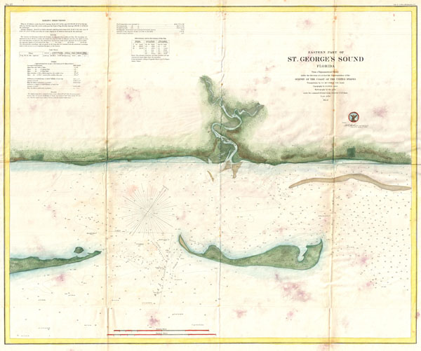
Eastern Part of St. George's Sound Florida.
sold
- Digital Map Information
- Suitable for large format printing
- File Size: 10.31 MB
- File Type: ZIP / TIFF
- ICC color profile embedded
- Delivered instantly via download link
A very attractive example of the rare 1859 U.S. Coast Survey map or nautical chart of St. George Sound, Florida. St. George Sound is the coast part of Tate's Hell State Forest, just southwest of Tallahassee, along the Florida Panhandle. ... (more details)
Uncommon nautical chart of the western Florida Keys, including Key West.
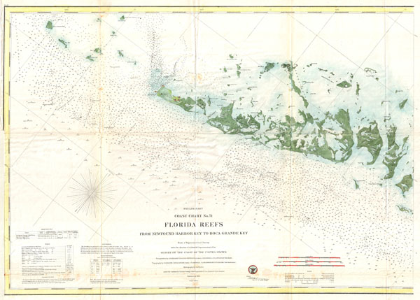
Preliminary Coast Chart No. 71 Florida Reefs From
sold
- Digital Map Information
- Suitable for large format printing
- File Size: 12.56 MB
- File Type: ZIP / TIFF
- ICC color profile embedded
- Delivered instantly via download link
A very attractive example of the rare 1859 U.S. Coast Survey Map the western Florida Keys. Centered on Key West, this map covers from Ramrod Key in the east to Boca Grande Key in the west. All of the Islands are named but only Key West ... (more details)
Rare trianguation chart of Southern Florida and the Keys.

Sketch F Showing the Progress of the Survey in Section No. VI (Lower Sheet) From Cape Florida to Tortugas Islands from 1845 to 1859.
sold
- Digital Map Information
- Suitable for large format printing
- File Size: 8.72 MB
- File Type: ZIP / TIFF
- ICC color profile embedded
- Delivered instantly via download link
A very attractive example of the 1859 U.S. Coast Survey triangulation chart or map of southern Florida and the Florida Keys. Covers from Key Biscayne Bay south along the Keys, past Key West, as far as the Marquesas Keys. Countless ... (more details)
A very early planning map of Prospect Park.

Design for Prospect Park in the City of Brooklyn.
sold
- Digital Map Information
- Suitable for large format printing
- File Size: 17.86 MB
- File Type: ZIP / TIFF
- ICC color profile embedded
- Delivered instantly via download link
This is a rare 1870 edition of Calvert Vaux and Frederick Law Olmsted's map of Prospect Park, Brooklyn. The map depicts the park as a whole and includes pathways, lakes, buildings, individual trees, rocks, and elevation measurements. The streets and avenues surrounding the park are also noted. (more details)
The original map upon which the northern Manhattan street grid is based.

Map of that Part of the City of new York North of 155th Street Showing the progress made in laying out Streets, Roads, Public Squares, and Places, by the Commissioners of the Central Park, under Chap. 565 of Laws of 1865 and of new Pier and Bulkhead lines under Chap. 697 of Laws of 1867.
sold
- Digital Map Information
- Suitable for large format printing
- File Size: 18.31 MB
- File Type: ZIP / TIFF
- ICC color profile embedded
- Delivered instantly via download link
A rare and unusual map of upper Manhattan, New York City, prepared and printed for inclusion in the 1870 Thirteenth Annual Report of the Board of Commissioners of the Central Park. Depicts the island of Manhattan north of 155th ... (more details)
Exceptional large folding map of Central Park.

Map of the Central Park January 1st 1870.
sold
- Digital Map Information
- Suitable for large format printing
- File Size: 10.02 MB
- File Type: ZIP / TIFF
- ICC color profile embedded
- Delivered instantly via download link
An altogether extraordinary hand colored map of New York City's Central Park prepared and printed for inclusion in the Thirteenth Annual Report of the Board of Commissioners of the Central Park. This is an extremely rare variant ... (more details)
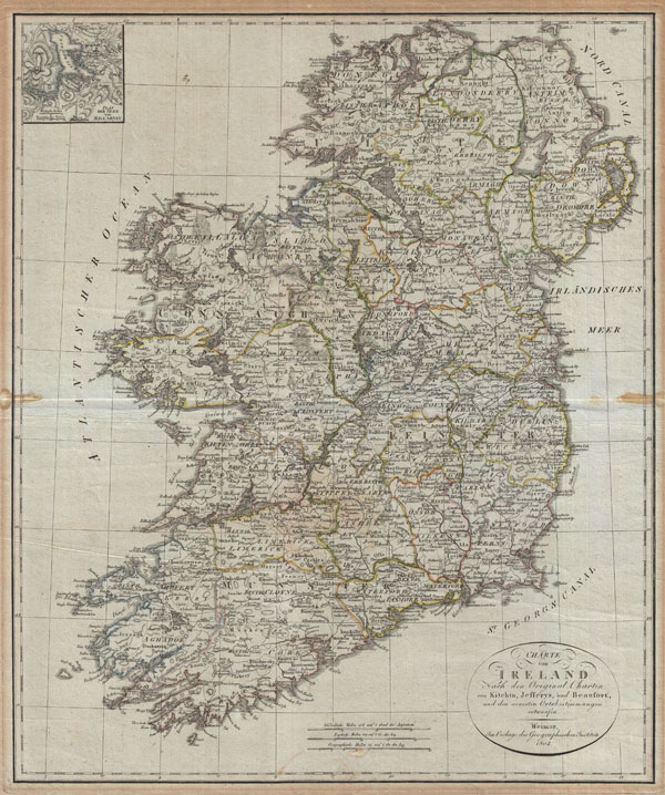
Charte von Ireland Nach den Original-Charten von Kitchin, Jefferys, und Beaufort, und den neuesten Ortsbestimmungen entworfen.
sold
- Digital Map Information
- Suitable for large format printing
- DPI: 300
- File Size: 19.79 MB
- File Type: ZIP / TIFF
- ICC color profile embedded
- Delivered instantly via download link
An uncommon map of Ireland dating to 1804. Though published by the German Geographical Institute, this map references the earlier work of Thomas Kitchin, Thomas Jefferys, and Daniel Beaufort. Covers the entirety of Ireland ... (more details)
A particularly beautiful example of this important nautical chart if the Chesapeake Bay.

Preliminary Chart of Delaware and Chesapeake Bays and the Sea Coast from Cape Henlopen to Cape Charles.
sold
- Digital Map Information
- Suitable for large format printing
- File Size: 17.8 MB
- File Type: ZIP / TIFF
- ICC color profile embedded
- Delivered instantly via download link
An exceptional example of the 1855 U.S. Coast Survey's progress chart of the Chesapeake Bay and Delaware Bay. Covers the Bay from the mouth of the Susquehanna River southwards as far as Cape Henry and Norfolk. Includes ... (more details)
A particularly beautiful example of this important nautical chart of New York Harbor.
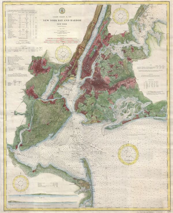
Coast Chart No. 120, New York Bay and Harbor, New York.
sold
- Digital Map Information
- Suitable for large format printing
- File Size: 30.85 MB
- File Type: ZIP / TIFF
- ICC color profile embedded
- Delivered instantly via download link
This magnificent map is rare 1910 reissue of the 1866 U. S. Coast Survey chart of New York City, its harbor, and environs. The 1866 U. S. C. S. chart represents the culmination of the Coast Survey's work in the New York ... (more details)