
Charlevoix, Pierre François Xavier de, S.J. (sold)
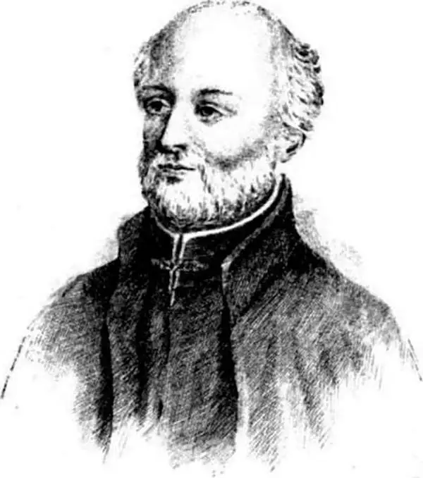
Pierre François Xavier de Charlevoix, S.J. (October 24 or 29, 1682 – February 1, 1761) was a French Jesuit priest, traveller, and historian, often considered the first historian of New France. He is best known for his Histoire et description generale de la Nouvelle France, in spite of the work being primarily based upon the manuscripts compiled by Gaspard-Joseph Chaussegros de Lery, a French Canadian military engineer active throughout the Great Lakes region in the early 18th century. Charlevoix had been commissioned by the French Crown and the Duke of Orleans to explore French holdings in the Americas, primarily in order to find a profitable route to the Pacific - perhaps via the rivers and lakes west of the Great Lakes suggested by De l'Isle and Lahontan. Charlevoix was not above inventing discoveries: the imaginary islands in Lake Superior that appear frequently in 18th century maps can be laid at Charlevoix's feet, the results of his efforts to flatter his patrons (and patron saints.)
Speculative rivers based on American Indian maps.
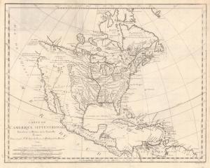
Carte de L'Amerique Septentrionale Pour servir a L'Histoire de la Nouvelle France.
sold
- Digital Map Information
- Suitable for large format printing
- File Size: 6.77 MB
- File Type: ZIP / TIFF
- ICC color profile embedded
- Delivered instantly via download link
An important and influential first edition first state 1743 map of North America by the French cartographer Jacques-Nicholas Bellin. The map is a profoundly French production, illustrating that nation's plans and ambitions for America in the decades preceding the French and Indian War (1754 - 1763). It includes speculative river systems and hopeful cities of gold and suggests broad, if ambiguous, territorial claims. (more details)
First state first edition of an iconic map of Quebec City.
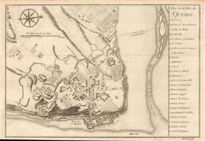
Plan de la Ville de Quebec.
sold
- Digital Map Information
- Suitable for large format printing
- DPI: 600
- File Size: 5.83 MB
- File Type: ZIP / TIFF
- ICC color profile embedded
- Delivered instantly via download link
A scarce 1744 first state first edition of Bellin's important map of Quebec City, Canada. Oriented to the west, Bellin's map covers the fortified center of Quebec City at the conjunction of the St. Laurence River and the St. Charles estuary. The map illustrates various fortifications as well as some 24 individual buildings including churches, schools, batteries and government buildings. Some of the surrounding farmland is also illustrated. On the east side of the city the port and is identified.
When Bellin drew this map Quebec City was a major center for the French Colony of Quebec with its strategic location dominating trade on the vital St. Lawrence artery. After the French and Indian War control of Quebec fell to the British. British rule proved both beneficial and magnanimous to the predominantly French population. (more details)
When Bellin drew this map Quebec City was a major center for the French Colony of Quebec with its strategic location dominating trade on the vital St. Lawrence artery. After the French and Indian War control of Quebec fell to the British. British rule proved both beneficial and magnanimous to the predominantly French population. (more details)
Elegant Map of the Atlantic, Showing Charlevoix' Voyage to and from North America.
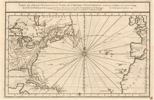
Carte De L'Ocean Occidental et Partie De L'Amerique Septentrionale Dressee pour l'intelligence du Journal du V oyage.
sold
- Digital Map Information
- Suitable for large format printing
- DPI: 600
- File Size: 8.7 MB
- File Type: ZIP / TIFF
- ICC color profile embedded
- Delivered instantly via download link
This is a 1744 Bellin map of the colonized regions of North America and the Caribbean Islands shown in relation to the coasts of Europe and Africa. It appeared in Pierre Francois Xavier de Charlevoix's 1744 Histoire et description generale de la Nouvelle France, one of the most comprehensive works on North America predating the French and Indian War. Charlevoix was a Jesuit missionary and traveler commissioned by the French Crown and the Duke of Orleans to explore French holdings in the Americas, particularly with a view towards finding a profitable route to the Pacific. Many hoped this in the network of rivers and lakes to the west of the Great Lakes, as suggested by earlier explorers and mapmakers such as Lahontan and De l'Isle. (more details)
An Attractively Engraved Map of the 'Île-d'Orléans
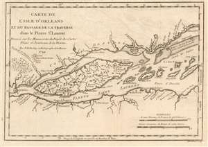
Carte de l'Isle d'Orleans et du Passage de la Traverse ans le Fleuve St.Laurent.
sold
- Digital Map Information
- Suitable for large format printing
- DPI: 600
- File Size: 4.63 MB
- File Type: ZIP / TIFF
- ICC color profile embedded
- Delivered instantly via download link
This is a beautiful example of Bellin's scarce 1744 map of the Île d'Orléans in the Saint Lawrence River. The map covers from Quebec City downstream to the Batures de Cap Brule.
Bellin originally prepared this map to illustrate Pierre François Xavier de Charlevoix's Histoire et description generale de la Nouvelle France, one of the most comprehensive works on North America predating the French and Indian War. Charlevoix was a Jesuit missionary and traveler commissioned by the French Crown and the Duke of Orleans to explore French holdings in the Americas, particularly with a view towards finding a profitable route to the Pacific. Many hoped this in the network of rivers and lakes to the west of the Great Lakes, as suggested by earlier explorers and mapmakers such as Lahontan and De l'Isle. It was engraved by Desbruslins Fils of Paris. Charlevoix's history thus proved exceptionally influential as one of the most comprehensive works on North America predating the French and Indian War. (more details)
Bellin originally prepared this map to illustrate Pierre François Xavier de Charlevoix's Histoire et description generale de la Nouvelle France, one of the most comprehensive works on North America predating the French and Indian War. Charlevoix was a Jesuit missionary and traveler commissioned by the French Crown and the Duke of Orleans to explore French holdings in the Americas, particularly with a view towards finding a profitable route to the Pacific. Many hoped this in the network of rivers and lakes to the west of the Great Lakes, as suggested by earlier explorers and mapmakers such as Lahontan and De l'Isle. It was engraved by Desbruslins Fils of Paris. Charlevoix's history thus proved exceptionally influential as one of the most comprehensive works on North America predating the French and Indian War. (more details)
First issue of an early depiction of Quebec.
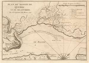
Plan du Bassin de Quebec et de ses Environs.
sold
- Digital Map Information
- Suitable for large format printing
- DPI: 600
- File Size: 5.06 MB
- File Type: ZIP / TIFF
- ICC color profile embedded
- Delivered instantly via download link
A scarce 1744 first state first issue of Bellin's map of the vicinity of Quebec City, Canada, illustrating the shallows of the St. Lawrence River. When this map was issued, Quebec dominated the French fur trade with its strategic position on a vital St. Lawrence artery. (more details)
An important Great Lakes Map showing the straits between Lake Superior, Lake Huron, and Lake Michigan.
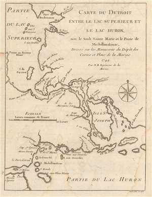
Carte du Detroit entre le Lac Superieur et le Lac Huron, ave le Sault Sainte Marie et la Poste de Michillimakinac, Dresse sur les Manuscrits du Depot des Cartes et Plans de la Marine.
sold
- Digital Map Information
- Suitable for large format printing
- DPI: 600
- File Size: 2.79 MB
- File Type: ZIP / TIFF
- ICC color profile embedded
- Delivered instantly via download link
This is a handsome example of Bellin's scarce 1744 map illustrating the straits between Lake Superior, Lake Huron, and Lake Michigan. The map covers from Batchawana Bay (Baye de Bachouanan) south to Whitefish Bay past Ille Parisienne to the St. Mary's River, which it follows inland, passing the Mission of St. Marie, Fort Sauvage, and Surgar Island (I. St. Georges) to the Isle St. Joseph and Lake Huron. It then follows westward as far as Bois Blanc Island and Point St. Ignace and the entrance to Lake Michigan. This is the same passage through which the United States-Canada border now runs.
Bellin originally prepared this map to illustrate Pierre François Xavier de Charlevoix's Histoire et description generale de la Nouvelle France, one of the most comprehensive works on North America predating the French and Indian War. Charlevoix was a Jesuit missionary and traveler commissioned by the French Crown and the Duke of Orleans to explore French holdings in the Americas, particularly with a view towards finding a profitable route to the Pacific. Many hoped this in the network of rivers and lakes to the west of the Great Lakes, as suggested by earlier explorers and mapmakers such as Lahontan and De l'Isle. It was engraved by Desbruslins Fils of Paris. Charlevoix's history thus proved exceptionally influential as one of the most comprehensive works on North America predating the French and Indian War. (more details)
Bellin originally prepared this map to illustrate Pierre François Xavier de Charlevoix's Histoire et description generale de la Nouvelle France, one of the most comprehensive works on North America predating the French and Indian War. Charlevoix was a Jesuit missionary and traveler commissioned by the French Crown and the Duke of Orleans to explore French holdings in the Americas, particularly with a view towards finding a profitable route to the Pacific. Many hoped this in the network of rivers and lakes to the west of the Great Lakes, as suggested by earlier explorers and mapmakers such as Lahontan and De l'Isle. It was engraved by Desbruslins Fils of Paris. Charlevoix's history thus proved exceptionally influential as one of the most comprehensive works on North America predating the French and Indian War. (more details)
The earliest obtainable example of the first map to introduce four fictional islands in Lake Superior. Islands later used to draw the post-Revolutionary War US-Canada border.
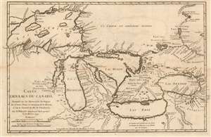
Carte des Lacs du Canada Dresse sur les Manuscrits du Depost des Carts, Plans et Journaux de la Marine et sur le Journal de RP. De Charlevoix.
sold
- Digital Map Information
- Suitable for large format printing
- Full resolution TIFF file
- ICC color profile embedded
- Delivered instantly via download link
This is the 1744 Bellin/ Charlevoix map of the Great Lakes, the most accurate map of the Great Lakes to date and the best to be produced since the De l'Isle map of 1718. It is also the earliest obtainable map, preceded only by a 1742 proof noted by Kershaw, to depict the four fictive islands in Lake Superior (Philippeux, Pontchartrain, Maurepas, and St. Anne) - islands that nonetheless significantly influenced the structuring of post-Revolutionary War borders between British Canada and the fledgling United States. It is also notable for being among the earliest maps to identify Detroit and the Port of Chicago. Bellin's map covers all five Great Lakes and their adjacent drainage systems in considerable detail, noting known fortifications, American Indian villages, missions, and some speculative topography (particularly in Michigan). (more details)
Imaginary (but important!) Islands of Lake Superior.
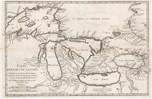
Carte des Lacs du Canada Dresse sur les Manuscrits du Depost des Carts, Plans et Journaux de la Marine et sur le Journal de RP. De Charlevoix.
sold
- Digital Map Information
- Suitable for large format printing
- Full resolution TIFF file
- ICC color profile embedded
- Delivered instantly via download link
This is the 1744 Bellin / Charlevoix map of the Great Lakes, the most accurate map of the Great Lakes to date and the best produced since the De l'Isle map of 1718. It is also the earliest obtainable map, preceded only by a 1742 proof noted by Kershaw, to depict the four fictive islands in Lake Superior (Philippeux, Pontchartrain, Maurepas, and St. Anne) - islands that nonetheless significantly influenced the structuring of post-Revolutionary War borders between British Canada and the fledgling United States. It is also notable for being among the earliest maps to identify Detroit and the Port of Chicago. Bellin's map covers all five Great Lakes and their adjacent drainage systems in considerable detail, noting known fortifications, American Indian villages, missions, and some speculative topography (particularly in Michigan). (more details)
Imaginary (but important!) Islands of Lake Superior.
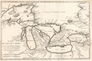
Carte des Lacs du Canada Dresse sur les Manuscrits du Depost des Carts, Plans et Journaux de la Marine et sur le Journal de RP. De Charlevoix.
sold
- Digital Map Information
- Suitable for large format printing
- File Size: 8.57 MB
- File Type: ZIP / TIFF
- ICC color profile embedded
- Delivered instantly via download link
This is the 1744 Bellin / Charlevoix map of the Great Lakes, the most accurate map of the Great Lakes to date and the best produced since the De l'Isle map of 1718. It is also the earliest obtainable map, preceded only by a 1742 proof noted by Kershaw, to depict the four fictive islands in Lake Superior (Philippeux, Pontchartrain, Maurepas, and St. Anne) - islands that nonetheless significantly influenced the structuring of post-Revolutionary War borders between British Canada and the fledgling United States. It is also notable for being among the earliest maps to identify Detroit and the Port of Chicago. Bellin's map covers all five Great Lakes and their adjacent drainage systems in considerable detail, noting known fortifications, American Indian villages, missions, and some speculative topography (particularly in Michigan). (more details)
An Attracive Map of Quebec in the Vicinity of the Saguenay River
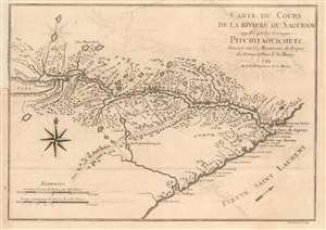
Carte Du Cours de la Riviere Saguenay appellee par les Sauvages Pitchitaouichetz
sold
- Digital Map Information
- Suitable for large format printing
- DPI: 600
- File Size: 5.15 MB
- File Type: ZIP / TIFF
- ICC color profile embedded
- Delivered instantly via download link
This is a 1744 Bellin map of the region of Quebec surrounding the course of the Saguenay River, reaching just short of Lake Saint-Jean. It shows the settlement of Chicoutimi (Chekoutimi on the map) in the location of present-day Saguenay. A track, running southwest, leads to Lac St. Charles near Quebec City.
This map appeared in Pierre Francois Xavier de Charlevoix's 1744 Histoire et description generale de la Nouvelle France, one of the most comprehensive works on North America predating the French and Indian War. Charlevoix was a Jesuit missionary and traveler commissioned by the French Crown and the Duke of Orleans to explore French holdings in the Americas, particularly with a view towards finding a profitable route to the Pacific. Many hoped this in the network of rivers and lakes to the west of the Great Lakes, as suggested by earlier explorers and mapmakers such as Lahontan and De l'Isle. (more details)
This map appeared in Pierre Francois Xavier de Charlevoix's 1744 Histoire et description generale de la Nouvelle France, one of the most comprehensive works on North America predating the French and Indian War. Charlevoix was a Jesuit missionary and traveler commissioned by the French Crown and the Duke of Orleans to explore French holdings in the Americas, particularly with a view towards finding a profitable route to the Pacific. Many hoped this in the network of rivers and lakes to the west of the Great Lakes, as suggested by earlier explorers and mapmakers such as Lahontan and De l'Isle. (more details)
State-of-the-art mapping of Lake Champlain at the outbreak of the French and Indian War.
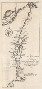
Karte von dem Fluße Richeliue und dem See Champlain Nach den Manuscripten des Schatzes von Karten Grüdrißen und Tagebüchern der Marine.
sold
- Digital Map Information
- Suitable for large format printing
- File Size: 3.14 MB
- File Type: ZIP / TIFF
- ICC color profile embedded
- Delivered instantly via download link
This is the 1756 German edition of the 1744 Bellin map of Lake Champlain and the St. Lawrence River. Bellin composed this map from French surveys conducted in the 1740s, making it one of the earliest accurate maps of Lake Champlain. This map was the state-of-the-art of Lake Champlain cartography and was the best available map of Lake Champlain at the outbreak of the French and Indian War (1754 - 1763) and the American Revolutionary War (1775 - 1783). Bellin's work was only supplanted when the British published Brassier's map in 1776. (more details)