
Le Rouge, Georges-Louis (sold)

Georges-Louis Le Rouge (c. 1707 - c. 1790) was a Paris based map publisher operating in the middle part of the 18th century. Le Rouge was born in Hanover Germany as Georg Ludwig, where he was educated and employed as a military engineer and surveyor. His father may have been the French architect Louis Remy de la Fosse (1659 - 1726), which would explain his early education in both engineering and draftsmanship. He assisted his father on a large-scale plan of Darmstadt, which he completed following his father's death in 1726. He may have remained in Darmstadt, but little is known of his life from 1726 - 1736, when he appears in Paris. Le Rouge acquired a position as military and civil engineer for King Louis XV and Louis XVI. Around this time, he Francophied his name to 'Le Rouge'. In 1740, he set up shop on the Rue Des Grands Augustins as an engraver, book publisher, and map publisher. He partnered with the English cartographer and engineer John Rocque (1709 - 1762), who became an important source for English maps, which Le Rouge re-engraved for French use. Despite being born German and adopting Paris as his home, Le Rouge was an ardent Anglophile and spent much of his time translating English books and maps into French. During his active period of roughly forty years Le Rouge produced thousands of maps and diagrams ranging from city and town plans, to atlases, plans of military campaigns and sea charts. He was a friend and correspondent of Benjamin Franklin (1706 - 1790), with whom he produced the important 1769 Franklin/Folger Map of the Gulf Stream. Franklin, who met Le Rouge in Paris, writes that 'He [Le Rouge] is, I believe, a proper person.' He was awarded for his diligence with the impressive but unstipended honorific 'Geographe du Roi'. They may not have served him swell during the French Revolution (1789 - 1799), as his last known work was published in 1789, just before the storming of the Bastille. The exact date of Le Rouge's death remains a mystery. By most estimates, he is believed to have been alive in 1790, but may have lived as long as 1794.
Spectacularly decorate map of the world attempting to reconcile the discoveries of Bering with the De Fonte apocrypha.
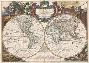
Mappe monde nouvelle : dediée a monseigneur le comte de Maurepas Ministre et Secretaire d'Etat.
sold
- Digital Map Information
- Suitable for large format printing
- DPI: 300
- File Size: 22.51 MB
- File Type: ZIP / TIFF
- ICC color profile embedded
- Delivered instantly via download link
A fine example of Le Rouge's highly decorative 1744 / 48 map of the world on a stereographic projection or, more commonly, in two hemispheres. Cartographically the map appears on the cusp of the great explorations of the 18th century, and as such, offers much of ... (more details)
Wonderful early decorative map showing both Korea and Japan in full.
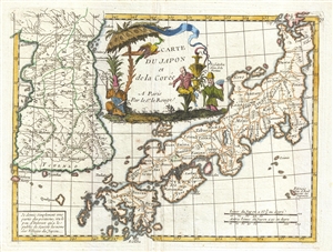
Carte du Japon et de la Corée.
sold
- Digital Map Information
- Suitable for large format printing
- DPI: 300
- File Size: 2.82 MB
- File Type: ZIP / TIFF
- ICC color profile embedded
- Delivered instantly via download link
An attractive 1748 map of Korea and Japan dawn by George Louis Le Rouge. The map covers both Korea and Japan in full and features a large central cartouche occupying the 'Sea of Korea' / 'Sea of Japan' region, although neither term us used. Korea is drawn ... (more details)
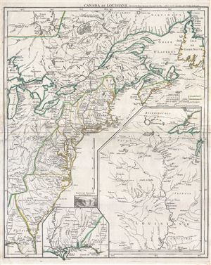
Canada et Louisiane.
sold
- Digital Map Information
- Suitable for large format printing
- DPI: 300
- File Size: 16.58 MB
- File Type: ZIP / TIFF
- ICC color profile embedded
- Delivered instantly via download link
A scarce 1755 map of the eastern part of North America by Georges-Louis Le Rouge. This important map was issued in the second year of the French and Indian War. Centered on the British colonies in North America, the main map covers from Lake Michigan ... (more details)
France's Northern and Southern Footholds in North America.
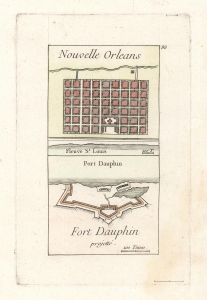
Nouvelle Orleans/ Fort Dauphin projetté.
sold
- Digital Map Information
- Suitable for large format printing
- DPI: 600
- File Size: 4.72 MB
- File Type: ZIP / TIFF
- ICC color profile embedded
- Delivered instantly via download link
This is George Louis le Rouge's scarce 1755 engraving of the French settlement at New Orleans, and the projected Fort Dauphin, on Ile Royale, now Cape Breton Island in Nova Scotia. These two outposts, apparently remote, bookended the territory in the New World for which the French were contending against the British at the time this map was produced and represented important coastal strongpoints for the French efforts to control the interior of North America. (more details)
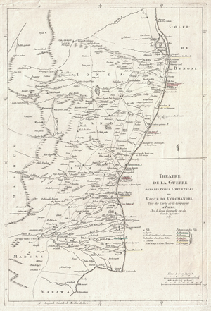
Theatre de la Guerre Dans Les Indes Orientales ou Coste de Coromandel Tiree des Cartes de la Compagnie a Paris…
sold
- Digital Map Information
- Suitable for large format printing
- DPI: 300
- File Size: 26.91 MB
- File Type: ZIP / TIFF
- ICC color profile embedded
- Delivered instantly via download link
This is an attractive 1759 map of Eastern India or Coromandel by George-Louis le Rouge. Covers the Indian coast from Marawa, in the south, northward past Pondicherry and Madras as far as Pallikata on the Bay of Bengal. Extends inland as far as ... (more details)
The site of the first naval engagement of the Seven Years' War.
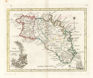
Isle Minorque a paris Chez Crepy.
sold
- Digital Map Information
- Suitable for large format printing
- DPI: 600
- File Size: 9.31 MB
- File Type: ZIP / TIFF
- ICC color profile embedded
- Delivered instantly via download link
This is a handsome, scarce example of George-Louis Le Rouge's 1759 map of Minorca. It was the last of a hundred maps in his Atlas Nouveau Portatif, which compiled an array of maps relevant to the Seven Years' War's European theatres. Minorca, therefore, was an important inclusion, being the site of the opening naval battle of that war in 1756. The map depicts Minorca and its provincial divisions as they stood during Britain's control of the Island, but the map was produced in the immediate aftermath of the battle by which the French ended British rule in Minorca, taking from Britain her primary Mediterranean base and effectively passing control of that sea to the French.
The maps for Le Rouge's Atlas were mainly sourced from those of Homann and Mayer, and the source for this map was published the year after the Battle of Minorca by Homann Heirs. It had been drawn by the French Royal Geographer, Jean de Beaurain; consequently it presented not only the most recent but the most authoritative mapping of the crucial Mediterranean strongpoint. (more details)
The maps for Le Rouge's Atlas were mainly sourced from those of Homann and Mayer, and the source for this map was published the year after the Battle of Minorca by Homann Heirs. It had been drawn by the French Royal Geographer, Jean de Beaurain; consequently it presented not only the most recent but the most authoritative mapping of the crucial Mediterranean strongpoint. (more details)
Revolutionary War Era Map of Cape Cod and Boston Harbor with dramatic cartouche.
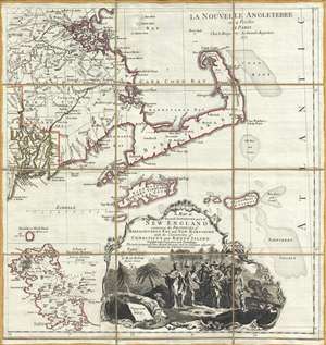
A Map of the most Inhabited part of New England containing the Provinces of Massachusets Bay and New Hampshire, with the Colonies of Connecticut and Rhode Island, divided into Counties and Townships: The whole composed form Actual Surveys and its Situation adjusted by Astronomical Observations.
sold
- Digital Map Information
- Suitable for large format printing
- Full resolution TIFF file
- ICC color profile embedded
- Delivered instantly via download link
A dramatic 1777 Braddock Mead and Le Rouge map of Cape Cod, Nantucket, Martha's Vineyard and Boston Bay. The map covers from Boston to Martha's Vineyard and from Narragansett Bay to Crab Bank and the Nantucket Shoals. This beautiful dissected ... (more details)
A French edition of Joshua Fisher's chart of Delaware Bay, considered to be one of the most important maps of the vicinity of Philadelphia ever produced.
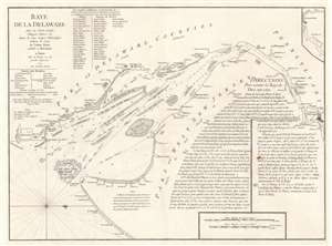
Baye de la Delaware Avec les Ports, Sondes, Dangers, Bancs, etc. depuis les Caps Jusqu'a Philadelphie d'Après la Carte de Joshua Fisher publiée a Philadelphie.
sold
- Digital Map Information
- Suitable for large format printing
- DPI: 600
- File Size: 28.52 MB
- File Type: ZIP / TIFF
- ICC color profile embedded
- Delivered instantly via download link
This 1777 George-Louis Le Rouge nautical chart or maritime map of Delaware Bay is a French edition of a near unobtainable chart by the self-taught Philadelphia cartographer Joshua Fisher. The chart depicts the region from just south of Cape Henlopen (labeled here as Cape James) to Philadelphia and from Delaware to Cape May and the Atlantic Ocean. Channels, shoals, ledges, flats, and other navigational hazards are illustrated, as are several different channels, all of which are labeled. Depth soundings are included along each of these channels as well. Coastal landmarks are identified, including both Cape Henlopen and Cape May with their latitudes noted. An inset of the waterway above Philadelphia is situated in the upper right corner. Detailed navigational instructions for the bay are included in the bottom right quadrant. (more details)
Richly-detailed Surveys of St. Kitts and Nevis.
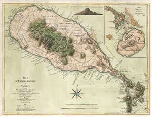
Isle St. Christophe ou St. Kitts Leve Par Ant: Ravell Chevalier Arpenteur Général des Isles de St. Christophe, Nevis et Montserrat. Par Jefferys en 1775. Traduit de l'Anglais A Paris par le Rouge Ingr. Geographe du Roi rue des Grands Augustus 1779 avec Privilege du Roi.
sold
- Digital Map Information
- Suitable for large format printing
- DPI: 600
- File Size: 22.65 MB
- File Type: ZIP / TIFF
- ICC color profile embedded
- Delivered instantly via download link
This Anthony Ravell’s survey map of the islands of St. Christopher and Nevis, in its 1779 French translation published by George-Louis Le Rouge. The map is based on the best 18th century survey of the islands, executed by Anthony Ravell, probably in 1717. Ravell's survey of St. Kitts was not committed to print until Jefferys engraved it for Robert Sayer in 1768; Jefferys would produce a further map of the island (combined with an inset map of Nevis) for his 1775 The West-India Atlas. It is this 1775 Jefferys map that Le Rouge copied to produce the present work. While the gap between 1717 and 1779 seems vast to our sensibility, at the time Ravell's survey remained the most current available: consider that the Mount and Page map of St. Christopher, published as late as 1783, was based on the surveys of Andrew Norwood, who died nearly a century prior in 1685. Norwood's survey also provided the source material for maps by Moll, Bowen, and Bellin. (more details)
Prepared for French participation in the American Revolutionary War.
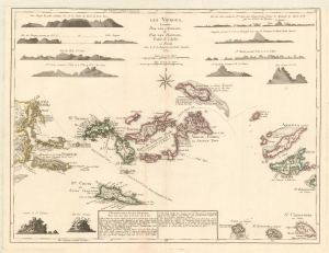
Les Vierges, Levées Par Les Anglais, et Par Les Dannois, Traduit de l'Anglais.
sold
- Digital Map Information
- Suitable for large format printing
- Full resolution TIFF file
- ICC color profile embedded
- Delivered instantly via download link
A rare 1779 map of the Virgin Islands by Georges-Louis Le Rouge prepared in anticipation of French participation in the American Revolutionary War (1775 - 1783). (more details)
Among the Earliest Maps of North America Published after the Revolution.
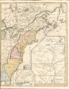
Carte d'une partie de l'Amérique Septentrionale, pour servir à l'histoire de la dernière guerre.
sold
- Digital Map Information
- Suitable for large format printing
- Full resolution TIFF file
- ICC color profile embedded
- Delivered instantly via download link
An example of Louis Le Rouge's 1787 map of North America, prepared soon after the conclusion of the American Revolutionary War (1775 - 1783), making it among the earliest published maps of the new country. It is notable for some curious cartographic choices on the part of Le Rouge, as well as the inclusion of many Native American tribes and settlements on the American frontier. (more details)