
Ramusio, Giovanni Battista (sold)
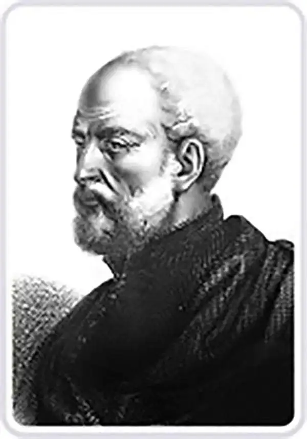
Giovanni Battista Ramusio (July 20, 1485 - July 10, 1557) was an Italian civil servant, humanist, scholar, historian, and geographer active in the middle part of the 16th century. Ramusio spent most of his life in the service of the Republic of Venice, first as part of that state's embassy to France, and later as a reporter on voyages and discoveries. He was born to an illustrious family in Treviso and moved to Vencie as a young man, where his father was a magistrate. He studied at the University of Padua but may not have received a full degree. He entered the civil service shortly after leaving the university and was immediately assigned to diplomatic service for his facility with languages, particularly French. His most significant contribution to cartography is his publication of Navigationi et Viaggi a collection of travel narratives he collected in his service to the state. The narratives include those of Marco Polo, Niccolò Da Conti, Magellan, Alvar Nuñez Cabeza de Vaca, Giosafat Barbaro, and Tomé Pires, among others. Some of the voyages appearing in the Navigationi et Viaggi are otherwise unknown, marking it as an exceptionally important volume. Ramusio died in Venice in 1557.
Most beautiful early woodcut of Hispaniola.
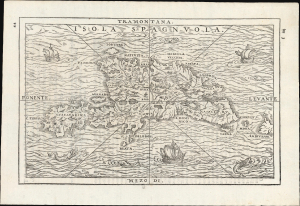
Isola Spagnuola.
sold
- Digital Map Information
- Suitable for large format printing
- File Size: 5.94 MB
- File Type: ZIP / TIFF
- ICC color profile embedded
- Delivered instantly via download link
This scarce 1565 woodcut map of Hispaniola, published in Giovanni Battista Ramusio's Navigationi et Viaggi, is the most attractive of the early depictions of the island. As with the 1556 first block of the map, it is geographically based on the 1534 Peter Martyr map of the island. But whereas the 1556 edition was a rote copy of the unadorned 1534 map, this 1565 second block is a beautiful example of the art of the woodcut, embellishing the waters around the island with waves, ships, and sea monsters, while the land is evocatively rendered with mountains and pictorial cities far beyond those presented in the earlier edition. (more details)
Contemporaneous Revision of Cortéz' Map
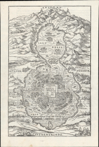
[Mexico].
sold
- Digital Map Information
- Suitable for large format printing
- File Size: 6.77 MB
- File Type: ZIP / TIFF
- ICC color profile embedded
- Delivered instantly via download link
This is the scarce 1565 issue of Giovanni Battista Ramusio's map of Mexico - Tenochtitlan, among the earliest depictions of the capital of the Aztec empire. It results from the combination of two firsthand accounts. Much of it is drawn from the report of Hernan Cortéz himself, but the present depiction incorporates the further report of an anonymous conquistador who accompanied Cortéz, and whose account adds further detail to the European view of the city for the first time. In its 1524 iteration, this was the first printed image of any American city. (more details)
First separate map of any Southeast Asian island to be based on actual observation.' - Suarez.
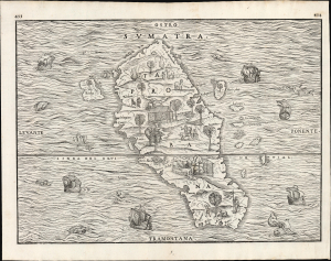
Sumatra / Taprobana.
sold
- Digital Map Information
- Suitable for large format printing
- File Size: 13.3 MB
- File Type: ZIP / TIFF
- ICC color profile embedded
- Delivered instantly via download link
This is the scarce 1565 second issue of Giovanni Battista Ramusio's seminal map of Sumatra, 'the first separate map of any Southeast Asian island to be based on actual observation' (Suarez) and one of the first European maps to focus narrowly on so remote a part of the world. It is derived ultimately from the charts of Pierre Crignon, Dieppe navigator and chartmaker, who attended the 1529 attempt of Jean and Raoul Parmentier to set up a trading colony in Sumatra on behalf of the French. The Parmentiers failed and died overseas, but the account of their voyage survived, along with the first detailed charting of the island - preserved in print here. (more details)
'An advance of the first importance' - Wheat
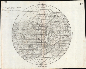
Universale Della Parte De Mondo Nuovamente Ritrovata.
sold
- Digital Map Information
- Suitable for large format printing
- File Size: 10.16 MB
- File Type: ZIP / TIFF
- ICC color profile embedded
- Delivered instantly via download link
This is Giovanni Battista Ramusio's scarce 1556 map of the Americas. It appeared in Ramusio's Navigationi et Viaggi, the first collection of explorers' first-hand accounts of their travels. It is among the earliest detailed representations of the Western Hemisphere, and was the first overall printed map of America to include placenames from Coronado's travels of 1540-1542. Wheat hailed this inclusion as an advance of the first importance, so far as the mapping of the American West is concerned. (more details)
The first state of the earliest specific map of Brazil.
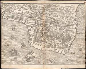
[Brasil].
sold
- Digital Map Information
- Suitable for large format printing
- Full resolution TIFF file
- ICC color profile embedded
- Delivered instantly via download link
This is the seminal, rare 1556 Giovanni Battista Ramusio map of Brazil, the first printed map to focus specifically on the area. It appeared in Ramusio's 1556 Navigationi et Viaggi, the first collection of explorers' first-hand accounts of their travels. The woodcut represents the first glimpse in print specifically of Brazil. The geographical information is generally credited to Giocomo Gastaldi (1500 - 1566). Much of that detail, and all of the socio-ethno-economic imagery of the map appears to have been drawn either from the 1519 manuscript Lopo Homem (1497 - 1572) Carta do Brasil, or from one or another manuscript of the Dieppe school. This is significant. An overwhelming percentage of maps of South America in the 16th century, printed and manuscript, carry either imagery or text describing the indigenous population as savages and cannibals. Of the early printed maps of Brazil, this is the only to highlight instead the harvesting of the lumber, which represented the initial economic draw for Europeans: Brazil wood, which when harvested and processed produced a highly desirable dye. Not only are the natives shown harvesting trees, and hauling them to the shore - they are also shown with parrots and monkeys, also desirable trade items. More significantly, the map shows a native exchanging lumber for a cup, given by men in European garb. This is one of the only printed maps to depict the active trade which had been underway for decades between French mariners from Normandy and the Tupi peoples of Brazil. Ramusio, as Venetian ambassador to France, may well have had access to French manuscript maps of the Dieppe school (which Surekha Davies notes were remarkable for their depiction of Brazilian indigenes as trade partners rather than predators.) The ships shown sailing the Atlantic here tell a related story: The Portuguese enjoyed a Papally decreed monopoly on the exploitation and colonization of Brazil under the 1494 Treaty of Tordesillas. French / Norman trade with Brazilian natives was done in defiance of the Portuguese, frequently meeting armed resistance. Of the five ships on this map, the smaller three sport the arms of Portugal. The two larger ships in the foreground bear the French fleurs-de-lis. This is a common thread appearing on Ramusio's maps: the notion that whatever the Portuguese have found around the world, the French ought to be able to take. (more details)
First Map to show New York Harbor. The First Map to name Canada.
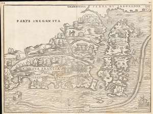
La Nuova Francia.
sold
- Digital Map Information
- Suitable for large format printing
- Full resolution TIFF file
- ICC color profile embedded
- Delivered instantly via download link
This is the seminal 1556 Giovanni Battista Ramusio map of the Northeast and Canada, 'the first printed map devoted to the New England region' (Osher), and the first map to apply a specific name to Canada. The map depicts the northeastern coast of North America from New York to the coast of Labrador, inclusive of New England and maritime Canada. It is the first map to reveal Giovanni da Verrazano's 1524 voyage to America and to depict his discoveries in what would become New York and New England. It is also among the most visually engaging early maps, being richly decorated with depictions of indigenous peoples, Europeans, flora and fauna, sailing ships, sea monsters, and demons. (more details)
The first separate map of any Southeast Asian island to be based on actual observation.' - Suarez
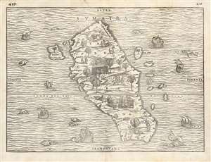
Sumatra Taprobana.
sold
- Digital Map Information
- Suitable for large format printing
- Full resolution TIFF file
- ICC color profile embedded
- Delivered instantly via download link
This is the seminal 1556 Giovanni Battista Ramusio map of Sumatra, 'the first separate map of any Southeast Asian island to be based on actual observation' (Suarez) and one of the first European maps to focus narrowly on so remote a part of the world. It appeared in Ramusio's i>Navigationi et Viaggi, the first collection of explorers' first-hand accounts of their travels. The source for this particular map came from the reports of Jean and Raoul Parmentier, who in 1529 ran the Portuguese blockade and attempted to compete with that power on behalf of the French by setting up a trading post at the Sumatran port of Ticon. It didn't work out - the Parmentier brothers died of fever, and only one ship of the expedition returned to France. The French saw no advantage in following up on this failure.
The woodcut, nonetheless represents the first glimpse in print of any specific Southeast Asian island, and this alone would make it desirable. It is moreover a very attractively executed woodcut: the sea around the island teems with fish, sea monsters, and ships - some of these bearing the Portuguese arms, and some flying the fleur de lis, alluding to the map's political context. There is also an element of Ramusio perhaps egging on his French audience, suggesting that whatever the Portuguese have found, the French ought to be able to take.
The map of the island is the first to entirely abandon Ptolemy's depiction of Taprobana, and along with Münster is among the first to associate the placename Taprobana definitively with Sumatra rather than Ptolemy's conflation of the place with Sri Lanka. It is moreover also the first map to approach an accurate outline of Sumatra, showing river inlets and bays on the coastline realistically. The island's inland features are presented pictorially, showing trees, dwellings, animals and people - men leading horses and camels, armed soldiers, men on horseback, and others harvesting coconuts. The variety and specificity of the depicted denizens suggest the presence of, and the author's familiarity with, organized social structures on Sumatra: an indication that here was not an uncivilized place, (like Ramusio's demon-haunted map of Canada), but somewhere one could go to do business. (more details)
The woodcut, nonetheless represents the first glimpse in print of any specific Southeast Asian island, and this alone would make it desirable. It is moreover a very attractively executed woodcut: the sea around the island teems with fish, sea monsters, and ships - some of these bearing the Portuguese arms, and some flying the fleur de lis, alluding to the map's political context. There is also an element of Ramusio perhaps egging on his French audience, suggesting that whatever the Portuguese have found, the French ought to be able to take.
The map of the island is the first to entirely abandon Ptolemy's depiction of Taprobana, and along with Münster is among the first to associate the placename Taprobana definitively with Sumatra rather than Ptolemy's conflation of the place with Sri Lanka. It is moreover also the first map to approach an accurate outline of Sumatra, showing river inlets and bays on the coastline realistically. The island's inland features are presented pictorially, showing trees, dwellings, animals and people - men leading horses and camels, armed soldiers, men on horseback, and others harvesting coconuts. The variety and specificity of the depicted denizens suggest the presence of, and the author's familiarity with, organized social structures on Sumatra: an indication that here was not an uncivilized place, (like Ramusio's demon-haunted map of Canada), but somewhere one could go to do business. (more details)
First separate map of any Southeast Asian island to be based on actual observation.' - Suarez
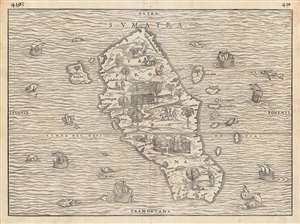
Sumatra/ Taprobana.
sold
- Digital Map Information
- Suitable for large format printing
- DPI: 600
- File Size: 35.47 MB
- File Type: ZIP / TIFF
- ICC color profile embedded
- Delivered instantly via download link
This is the seminal 1556 Giovanni Battista Ramusio map of Sumatra, 'the first separate map of any Southeast Asian island to be based on actual observation' (Suarez) and one of the first European maps to focus narrowly on so remote a part of the world. It appeared in Ramusio's i>Navigationi et Viaggi, the first collection of explorers' first-hand accounts of their travels. The source for this map came from the reports of Jean and Raoul Parmentier, who in 1529 ran the Portuguese blockade and attempted to compete with that power on behalf of the French by setting up a trading post at the Sumatran port of Ticon. It didn't work out - the Parmentier brothers died of fever, and only one ship of the expedition returned to France. The French saw no advantage in following up on this failure.
The woodcut represents the first glimpse in print of any specific Southeast Asian island, and this alone would make it desirable. It is moreover a very attractively executed woodcut: the sea around the island teems with fish, sea monsters, and ships - some of these bearing the Portuguese arms, and some flying the fleur de lis, alluding to the map's political context. There is also an element of Ramusio encouraging his French audience, suggesting that whatever the Portuguese have found in the world, the French ought to be able to take.
The map of the island is the first to entirely abandon Ptolemy's depiction of Taprobana, and along with Münster is among the first to associate that placename definitively with Sumatra rather than Ptolemy's conflation of the place with Sri Lanka. Moreover, it is the first map to approach an accurate outline of Sumatra, realistically showing river inlets and bays on the coastline. The island's inland features are presented pictorially, showing trees, dwellings, animals, and people - men leading horses and camels, armed soldiers, men on horseback, and others harvesting coconuts. The variety and specificity of the depicted denizens suggest the presence of, and the author's familiarity with, organized social structures on Sumatra: an indication that here was not an uncivilized place, (like Ramusio's demon-haunted map of Canada), but somewhere one could go to do business. (more details)
The woodcut represents the first glimpse in print of any specific Southeast Asian island, and this alone would make it desirable. It is moreover a very attractively executed woodcut: the sea around the island teems with fish, sea monsters, and ships - some of these bearing the Portuguese arms, and some flying the fleur de lis, alluding to the map's political context. There is also an element of Ramusio encouraging his French audience, suggesting that whatever the Portuguese have found in the world, the French ought to be able to take.
The map of the island is the first to entirely abandon Ptolemy's depiction of Taprobana, and along with Münster is among the first to associate that placename definitively with Sumatra rather than Ptolemy's conflation of the place with Sri Lanka. Moreover, it is the first map to approach an accurate outline of Sumatra, realistically showing river inlets and bays on the coastline. The island's inland features are presented pictorially, showing trees, dwellings, animals, and people - men leading horses and camels, armed soldiers, men on horseback, and others harvesting coconuts. The variety and specificity of the depicted denizens suggest the presence of, and the author's familiarity with, organized social structures on Sumatra: an indication that here was not an uncivilized place, (like Ramusio's demon-haunted map of Canada), but somewhere one could go to do business. (more details)
A rare, early copperplate map of India, Persia, and Arabia.
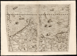
Seconda Tavola.
sold
- Digital Map Information
- Suitable for large format printing
- File Size: 10.98 MB
- File Type: ZIP / TIFF
- ICC color profile embedded
- Delivered instantly via download link
This is a scarce copperplate edition, commonly dated 1563, of the first accurate map of South Asia, including India, Arabia, and the Persian Gulf. It was drawn for Giovanni Battista Ramusio by his friend, the great cartographer Giacomo Gastaldi. The map was first published in Volume I of Ramusio's delle Navigationi et Viaggi in 1554, but this copperplate edition was engraved by Niccolo Nelli to replace the original woodblock after it was lost in a fire. (more details)
'An advance of the first importance' - Wheat
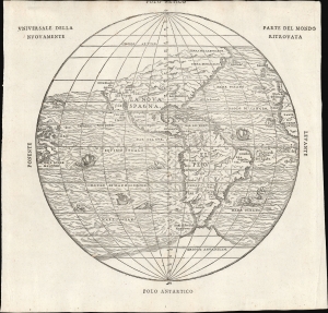
Universale Della Parte De Mondo Nuovamente Ritrovata.
sold
- Digital Map Information
- Suitable for large format printing
- File Size: 7.62 MB
- File Type: ZIP / TIFF
- ICC color profile embedded
- Delivered instantly via download link
This is Giovanni Battista Ramusio's scarce 1565 map of the Americas. It first appeared in Ramusio's 1556 Navigationi et Viaggi, the first collection of explorers' first-hand accounts of their travels. It is among the earliest detailed representations of the Western Hemisphere, predated only by the 1540 Münster and the extremely rare 1554 Bellère map. This was the first printed map of America to include placenames from Coronado's travels of 1540-1542: Wheat hailed this inclusion as 'an advance of the first importance, so far as the mapping of the American West is concerned.'
Ramusio commissioned Giacomo Gastaldi (1500 - 1566) to compose this map, along with the others appearing in the Navigationi et Viaggi; that much of its detail agrees with the western portion of Gastaldi's 1546 world map supports this. (more details)
Ramusio commissioned Giacomo Gastaldi (1500 - 1566) to compose this map, along with the others appearing in the Navigationi et Viaggi; that much of its detail agrees with the western portion of Gastaldi's 1546 world map supports this. (more details)
Ramusio Captures the French Coasting of Africa.
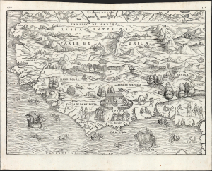
Parte De L'Africa
sold
- Digital Map Information
- Suitable for large format printing
- File Size: 13.42 MB
- File Type: ZIP / TIFF
- ICC color profile embedded
- Delivered instantly via download link
This is Giovanni Battista Ramusio's 1556 / 1565 map of Western Africa. It is the first specific map of the region to be based substantially on contemporaneous report (that of the diplomat and author Leo Africanus). Also, it reveals Ramusio's familiarity with African coastal charts of the Dieppe school of chartmakers, as evidenced not only in the map's distinctive coastal outline but also in its lively decorative elements. (more details)
Earliest specific map of Brazil.
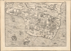
[Brasil].
sold
- Digital Map Information
- Suitable for large format printing
- File Size: 12.38 MB
- File Type: ZIP / TIFF
- ICC color profile embedded
- Delivered instantly via download link
This Giovanni Battista Ramusio's scarce 1565 map of Brazil, the first printed map to focus specifically on the area. It first appeared in Ramusio's 1556 Navigationi et Viaggi, the first collection of explorers' first-hand accounts of their travels. The woodcut represents the first glimpse in print specifically of Brazil. The geographical information is generally credited to Giocomo Gastaldi (1500 - 1566). Much of that detail, and all of the socio-ethno-economic imagery of the map appears to have been drawn either from the 1519 manuscript Lopo Homem (1497 - 1572) Carta do Brasil, or from one or another manuscript of the Dieppe school. This is significant. An overwhelming percentage of maps of South America in the 16th century, printed and manuscript, carry either imagery or text describing the indigenous population as savages and cannibals. Of the early printed maps of Brazil, this is the only to highlight instead the harvesting of the lumber, which represented the initial economic draw for Europeans: Brazil wood, which when harvested and processed produced a highly desirable dye. Not only are the natives shown harvesting trees and hauling them to the shore - they are also shown with parrots and monkeys, also desirable trade items. More significantly, the map shows a native exchanging lumber for a cup, given by men in European garb. This is one of the only printed maps to depict the active trade which had been underway for decades between French mariners from Normandy and the Tupi peoples of Brazil. Ramusio, as Venetian ambassador to France, may well have had access to French manuscript maps of the Dieppe school (which Surekha Davies notes were remarkable for their depiction of Brazilian indigenes as trade partners rather than predators.) The ships shown sailing the Atlantic here tell a related story: The Portuguese enjoyed a Papally decreed monopoly on the exploitation and colonization of Brazil under the 1494 Treaty of Tordesillas. French / Norman trade with Brazilian natives was done in defiance of the Portuguese, frequently meeting armed resistance. Of the five ships on this map, the smaller three sport the arms of Portugal. The two larger ships in the foreground bear the French fleurs-de-lis. This is a common thread appearing on Ramusio's maps: the notion that whatever the Portuguese have found around the world, the French ought to be able to take. (more details)
Capturing a glimpse of Cartier's meeting with the St. Lawrence Iroquois.
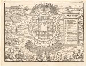
La Terra de Hochelaga Nella Nova Francia
sold
- Digital Map Information
- Suitable for large format printing
- DPI: 600
- File Size: 11.86 MB
- File Type: ZIP / TIFF
- ICC color profile embedded
- Delivered instantly via download link
This is an attractive example of the scarce first map of 'Montreal.' Printed in 1565, it is what Schwartz calls 'The very first plan of a village in the United States or Canada,' and it is the earliest printed map to use the place name 'Monte Real,' which would become Montreal. Perhaps even more significantly, this woodcut is one of the only images from the Discovery Period of an intact indigenous town, and its customs. (more details)
Capturing a glimpse of Cartier's meeting with the St. Lawrence Iroquois.
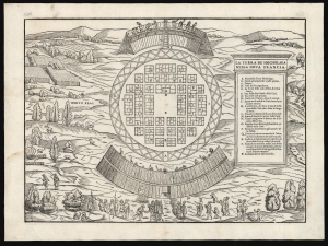
La Terra de Hochelaga Nella Nova Francia.
sold
- Digital Map Information
- Suitable for large format printing
- File Size: 13.66 MB
- File Type: ZIP / TIFF
- ICC color profile embedded
- Delivered instantly via download link
This is an attractive example of the first map of 'Montreal,' in its scarce 1565 second edition. Its first 1556 printing was what Schwartz called 'The very first plan of a village in the United States or Canada,' and it is the earliest printed map to use the place name 'Monte Real,' which would become Montreal. Perhaps even more significantly, this woodcut is one of the only images from the Discovery Period of an intact indigenous town, reflecting its customs. (more details)
First Map to detail New York Harbor; the First Map to name Canada.
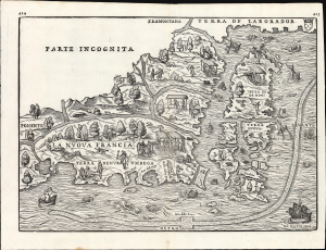
La Nuova Francia.
sold
- Digital Map Information
- Suitable for large format printing
- File Size: 13.96 MB
- File Type: ZIP / TIFF
- ICC color profile embedded
- Delivered instantly via download link
This is a superb example of the seminal 1565 Giovanni Battista Ramusio map of the Northeast and Canada, The first printed map devoted to the New England region (Osher) and the first map to apply a specific name to Canada. Significantly, it is the first map to focus specifically on Giovanni da Verrazzano's 1524 discoveries in what would become New York and New England - making it the first map to depict New York Bay and Harbor. (more details)
The First Map to show New York Harbor; the First Map to name Canada.
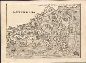
La Nuova Francia.
sold
- Digital Map Information
- Suitable for large format printing
- DPI: 600
- File Size: 14.84 MB
- File Type: ZIP / TIFF
- ICC color profile embedded
- Delivered instantly via download link
This is the seminal 1565 Giovanni Battista Ramusio map of the Northeast and Canada, 'The first printed map devoted to the New England region'(Osher) and the first map to apply a specific name to Canada. The map depicts the northeastern coast of North America from New York to the coast of Labrador, inclusive of New England and maritime Canada. In particular, it is the first map to reveal Giovanni da Verrazano's 1524 voyage to America and to depict his discoveries in what would become New York and New England. It is also among the most visually engaging early maps, being richly decorated with depictions of indigenous peoples, Europeans, flora and fauna, sailing ships, sea monsters, and demons. (more details)
One of the Earliest Depictions of West Africa Based on Contemporary Report
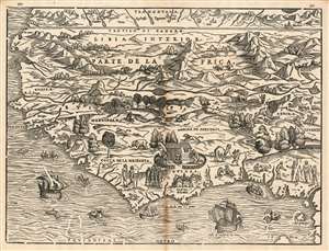
Parte De L'Africa
sold
- Digital Map Information
- Suitable for large format printing
- DPI: 600
- File Size: 12.46 MB
- File Type: ZIP / TIFF
- ICC color profile embedded
- Delivered instantly via download link
This is G. B. Ramusio's 1556 map of Western Africa, one of the earliest maps of Africa to be based substantially on contemporaneous information. The map covers western Africa and the Guinea Coast, stretching from modern day Mauritania to Cameroon. It appeared in Ramusio's Delle Navigationi et Viaggi, the first collection of first-hand travelers' reports. With respect to Africa, Ramusio relied both on information of Portuguese travelers and the reports of Leo Africanus, the author of the Descrittione dell’Africa which appeared in the third volume of Ramusio's Viaggi. The coastline shows remarkable detail for the period: in addition to the prominently-featured Castel de la Mina, Portugal’s infamous slave fortresses in Africa in present-day Ghana, the map also names Cape Verde, the Gambia River, Senegal, Sierra Leone, and the Mandinga River - all along the western coastline which would prove to be France's primary colonial foothold in the 17th century and later during the scramble for Africa. Although France would not establish a strong colonial presence here until well into the 17th century, as early as 1556 we see the notion of a French colony in western Africa promoted. Ramusio's map features a ship bearing the Portuguese arms sailing to La Mina, but another ship – this one with the French fleur de lis – is shown sailing to Sierra Leone and the Costa de la Melegeta.
Perhaps unsurprisingly, the map is less revelatory with respect to the interior of Africa, which would be opaque to European explorers until the end of the 19th century. Some place names do appear to have some basis in actual report. The Empire of Benin is named: the Portuguese had contacted this kingdom, bringing back tales of a noble city with a powerful king, and trading metal and guns for ivory, gold, and slaves. The English, too, had contacted Benin by 1553. In the northern extremes of the map, above the Tropic of Cancer, several cities appear - notably Segelmesse, and the oasis of Berdoa, all reported by Africanus. (more details)
Perhaps unsurprisingly, the map is less revelatory with respect to the interior of Africa, which would be opaque to European explorers until the end of the 19th century. Some place names do appear to have some basis in actual report. The Empire of Benin is named: the Portuguese had contacted this kingdom, bringing back tales of a noble city with a powerful king, and trading metal and guns for ivory, gold, and slaves. The English, too, had contacted Benin by 1553. In the northern extremes of the map, above the Tropic of Cancer, several cities appear - notably Segelmesse, and the oasis of Berdoa, all reported by Africanus. (more details)