
War Route Maps (sold)
Monumental and rare World War II route map.
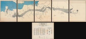
Operations from Omaha Beach to Elbe River.
sold
- Digital Map Information
- Suitable for large format printing
- Full resolution TIFF file
- ICC color profile embedded
- Delivered instantly via download link
This is a monumental and impressive 1945 John A. LeDonne route map of Europe tracing the movements of the 1115th Engineer Combat Group during World War II. It is the largest and most impressive 'Route Map' to emerge out of World War II (1939 - 1945). (more details)
Monumental and rare World War II route map.
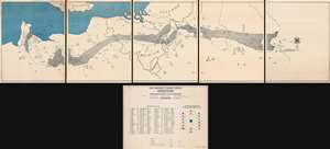
Operations from Omaha Beach to Elbe River.
sold
- Digital Map Information
- Suitable for large format printing
- Full resolution TIFF file
- ICC color profile embedded
- Delivered instantly via download link
This is a monumental and impressive 1945 John A. LeDonne route map of Europe tracing the movements of the 1115th Engineer Combat Group during World War II. It is the largest and most impressive 'Route Map' to emerge out of World War II (1939 - 1945). (more details)
WWII in the Pacific: drafted to discharged.
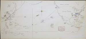
[Untitled Manuscript Pacific War Route Map].
sold
- Digital Map Information
- Suitable for large format printing
- File Size: 2.77 MB
- File Type: ZIP / TIFF
- ICC color profile embedded
- Delivered instantly via download link
A remarkable survival, this is a c. 1947 manuscript pictorial route map of the Pacific War following the World War II service of a U.S. Navy man. Pictorial vignettes highlight the sailor's wartime experience: swearing in, working at the Charleston Navy Yard, surveying the Pacific, weathering typhoons, mine sweeping, good times in Shanghai, and the voyage home. Dated lines trace his travels, with red dates marking wartime movements and yellow dates identifying his return. (more details)
A complete set of 79th Infantry Division route maps from World War II - maps created by the soldiers for the soldiers.
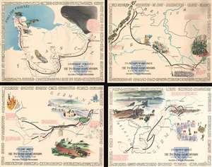
Through France with the 79th Infantry Division 14 June to 29 Aug, 1944. Maj Gen I.T. Wyche, Commanding. / To Belgium and Back wit the 79th Infantry Division 31 Aug to 25 Oct, 1944 Maj. Gen. I. T. Wyche, Commanding. / To the Rhine with the 79th Infantry Division 25 Oct to 14 Feb. 1945 Maj Gen I.T. Wyche, Commanding. / Over the Rhine with the 79th Infantry Division 17 Feb to 9 May 1945 Maj. Gen. I. T. Wyche, Commanding.
sold
- Digital Map Information
- Suitable for large format printing
- File Size: 161.21 MB
- File Type: ZIP / TIFF
- ICC color profile embedded
- Delivered instantly via download link
This is a set of four Steve Kaliher and Harry D. White pictorial World War II route maps of the 79th Infantry's advance from Normandy to Germany. Presented on four separate sheets, a detailed summary of the division's progress across northern Europe from Utah Beach (one of the four Normandy beaches assaulted by Allied troops only eight days on what has become known as D-Day) to Mulheim, Germany. Each map traces a sequence of a few months in the combat history of the 79th with red lines labeled with dates marking the advance week by week and sometimes day to day. Text blocks narrate parts of the advance, providing insight into what the division accomplished during their over 300 days of combat. Cities and towns are identified throughout all four maps, as are rivers. Each map is framed by the names of cities and towns that the division passed through on their advance, fought for, and liberated, adding yet another level of memory to each piece. (more details)
One of the few route maps published during the war. An example with special provenance.
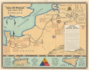
'Hell on Wheels' 1942 - 1943 - 1944. Second United States Armored Division.
sold
- Digital Map Information
- Suitable for large format printing
- Full resolution TIFF file
- ICC color profile embedded
- Delivered instantly via download link
A rarity in an underappreciated genre, this is the 1944/45 Marion E. Baker World War II Second Armored Division Pictorial Route Map of Europe. Two elements stand out from most World War II (1939 - 1945) route maps. One is the scope of the Second Armored Division campaign, including North Africa, Sicily, and Western Europe. The second is that, unlike most route maps, the present map was published during the war, making it a part of the war experience, instead of a post-war summary. (more details)
The 29th Infantry: from the U.S. to D-Day to V-E Day.
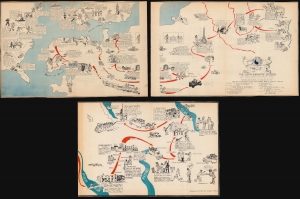
This is a 1945 29th Infantry Division World War II pictorial route map of Europe tracing the 29th's movements from the United States to England, across the English Channel to France on D-Day, and through Europe to Germany and the end of the war. Created by an unknown artist, the map provides a chronicle of the division's exploits meant for its veterans as a souvenir of all they had accomplished. (more details)
The 29th Infantry: from the U.S. to D-Day to V-E Day.
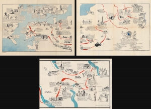
This is a 1945 29th Infantry Division World War II pictorial route map of Europe tracing the 29th's movements from the United States to England, across the English Channel to France on D-Day, and through Europe to Germany and the end of the war. Created by an unknown artist, the map provides a chronicle of the division's exploits meant for its veterans as a souvenir of all they had accomplished. (more details)
The only combat unit sent to WWII Europe by an independent South American nation.
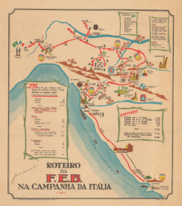
Roteiro Da F.E.B. Na Campanha da Itália. 2a Ediçāo.
sold
- Digital Map Information
- Suitable for large format printing
- File Size: 7.83 MB
- File Type: ZIP / TIFF
- ICC color profile embedded
- Delivered instantly via download link
A rare find, this is a 1945 Alberto Lima pictorial World War II route map of the Força Expedicionária Brasileira (FEB, or Brazilian Expeditionary Force) in Italy. The map highlights the movements, battles, and victories of the only combat unit sent to WWII Europe by an independent South American nation. (more details)
Getting reinforcements to the front line during World War II.
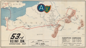
53rd Reinf. Bn. Operations Map.
sold
- Digital Map Information
- Suitable for large format printing
- File Size: 27.43 MB
- File Type: ZIP / TIFF
- ICC color profile embedded
- Delivered instantly via download link
This is an extremely rare c. 1945 World War II 53rd Reinforcement Battalion route map of Europe. This map follows the 53rd Reinforcement Battalion from Chard, England, to Bamberg, Germany, from January 13, 1944, through July 13, 1945. It also informs on the numbers of reinforcements it processed, illustrating the important role this battalion played in winning World War II. (more details)
German bicycle battalion on the Eastern Front.
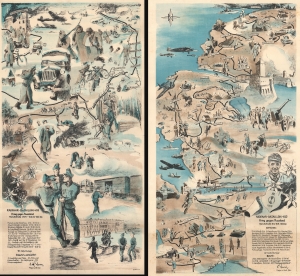
Radfahr-Bataillon 402 Krieg gegen Russland Marschstrecke 1.12.41 - 10.8.42 - 650 Km. / Radfahr - Bataillon 402 Krieg gegen Russland Marschstrecke 22.6 - 30.11. 1900 Km.
sold
- Digital Map Information
- Suitable for large format printing
- Full resolution TIFF file
- ICC color profile embedded
- Delivered instantly via download link
This is a set of two c. 1942 Beisser pictorial route maps of a German bicycle battalion on the Eastern Front during World War II (1939 - 1945). While route maps following American and British units during World War II are prevalent, their German counterparts are exceedingly rare. (more details)
VIII Corps from Normandy to the German-Czech border.
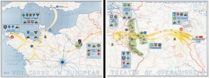
1943 VIII Corps in the European Theater of Operations 1945.
sold
- Digital Map Information
- Suitable for large format printing
- File Size: 80.76 MB
- File Type: ZIP / TIFF
- ICC color profile embedded
- Delivered instantly via download link
On two sheets, this is the 1945 VIII Corps route map of the VIII Corps in the European Theater during World War II (1939 - 1945). It is one of the largest, most impressive, and rarest of the route-map genre. (more details)
One of the few route maps published during the war.
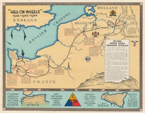
'Hell on Wheels' 1942 - 1943 - 1944. Second United States Armored Division.
sold
- Digital Map Information
- Suitable for large format printing
- File Size: 78.4 MB
- File Type: ZIP / TIFF
- ICC color profile embedded
- Delivered instantly via download link
A rarity in an underappreciated genre, this is the 1944/45 Marion E. Baker World War II Second Armored Division Pictorial Route Map of Europe. Two elements stand out from most World War II (1939 - 1945) route maps. One is the scope of the Second Armored Division campaigning, stretching to including North Africa, Sicily, and western Europe. The second is that, unlike most route maps, the present map was published during the war, making it a part of the war experience, instead of a post-war summary. (more details)
Restoring civilian governments in occupied and liberated Europe.
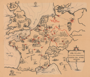
European Civil Affairs Division.
sold
- Digital Map Information
- Suitable for large format printing
- File Size: 22.76 MB
- File Type: ZIP / TIFF
- ICC color profile embedded
- Delivered instantly via download link
This is a 1945 Larry Furman World War II pictorial route map of western and central Europe highlighting the European Civil Affairs Division (ECAD). ECAD was responsible for reestablishing civilian governments in liberated and occupied territories. This map is true WWII scarcity, recorded only at the Library of Congress. (more details)
American soldiers operating railroads in wartime France and Germany.
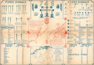
746 R.O.B. / 746 Railway Operating Battalion SNCF Railroad.
sold
- Digital Map Information
- Suitable for large format printing
- Full resolution TIFF file
- ICC color profile embedded
- Delivered instantly via download link
This is a set of 2 infographic maps by Richard E. Phillips detailing the 746th Railway Operating Battalion's involvement in World War II from its activation until the late summer of 1945. These pieces provide visual summaries of the battalion's time in France and Germany, including illustrating signals and providing translations for French and German words the battalion encountered. (more details)
Korean War Route Map - unrecorded!
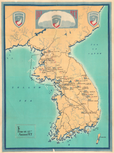
187 RCT. / To From the 187th Airborne RCT.
sold
- Digital Map Information
- Suitable for large format printing
- File Size: 34.2 MB
- File Type: ZIP / TIFF
- ICC color profile embedded
- Delivered instantly via download link
This is a 1951 situation/route map of the 187th Airborne Regimental Combat Team (RCT) during the first year of the Korean War (1950 - 1953), here in its only known example. Doubtless inspired by the tradition of division route maps popularized in World War II, this is the only such known map to focus on a specific unit during the Korean War. (more details)
Unique WWII Axis Route Map.
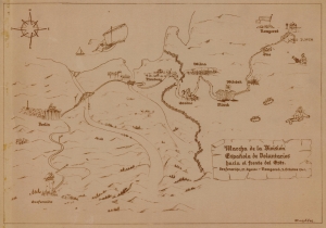
Marcha de la División Español,a de Voluntarios hacia el frente del Este. Grafenwöhe, 21. Agosto - Nowgorod, 9. Octubre 1941.
sold
- Digital Map Information
- Suitable for large format printing
- File Size: 3.19 MB
- File Type: ZIP / TIFF
- ICC color profile embedded
- Delivered instantly via download link
This is a unique 1942 World War II Axis-made unit route map illustrating the war experience of the Spanish Volunteer Division (Spanish Blue Division). The Blue Division was a group of staunchly anti-Bolsehevic Spanish volunteers who joined the German Wehrmacht on the Eastern Front against Communist Russia. It is one of VERY few examples of a WWII unit route map made by Axis forces. (more details)
Comic record of the elusive 951 Aviation Engineer Topographic Company.
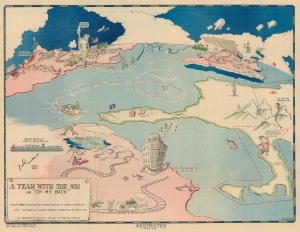
A Year with the 951 or 'Oh My Back'.
sold
- Digital Map Information
- Suitable for large format printing
- Full resolution TIFF file
- ICC color profile embedded
- Delivered instantly via download link
This is a c. 1942 W. Potter 951st Aviation Engineer Topographic Company pictorial route map of Africa, Europe, and the United States. It is one of the most comic maps in the World War II route maps genre. Loosely tracing the company's movements through the end of 1942, Potter fills the map with hilarious vignettes and inside jokes. Curiously, this map is the only known reference to the 951st Aviation Engineer Topographic Company. (more details)
Influential to the Route Map Genre.
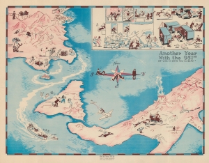
Another Year with the 951st. or 'Like Ah Done Tol' Yu Befo'.
sold
- Digital Map Information
- Suitable for large format printing
- File Size: 19.5 MB
- File Type: ZIP / TIFF
- ICC color profile embedded
- Delivered instantly via download link
This is a c. 1943 World War II W. Potter pictorial route map of the 951st Aviation Engineer Topographic Company in North Africa, Sicily, and Italy. The map is distinctive as one of the few WWII Route Maps published during, rather than after, the war, and thus may have influenced the genre's rise, direction, and popularity. (more details)
Ephemeral WWII mimeograph Route Map following the 318th Infantry Regiment.
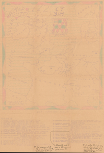
Map Route CT 318.
sold
- Digital Map Information
- Suitable for large format printing
- Full resolution TIFF file
- ICC color profile embedded
- Delivered instantly via download link
This is a 1945 mimeographed World War II unit route map of the 318th Infantry Regiment in Europe. It records the regiment's fight across Europe, noting milestones, and includes an operational report of the last days of combat in the European theatre, May 6-7, 1945, on the verso. As a mimeograph, this route map is unusual for the genre and limited by the medium, making it exceptionally ephemeral. (more details)
Algerian Colonial infantry unit during World War II.
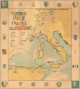
3e Division D'Infanterie Algerienne Tunisie Italie France Allemagne.
sold
- Digital Map Information
- Suitable for large format printing
- File Size: 40.92 MB
- File Type: ZIP / TIFF
- ICC color profile embedded
- Delivered instantly via download link
This is a rare 1945 World War II pictorial route map of the 3rd Algerian Infantry Division in North Africa, Italy, France, and Germany. The map follows the Division from activation until the end of the war and uses vignette illustrations to highlight important moments during the Division's war. This piece holds historical significance as a route map dedicated to a colonial unit. It is a glimpse into the wartime experiences of a group that is often overlooked by popular histories published today. (more details)
Rare route map following an armored combat command.
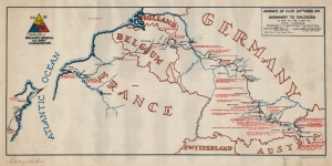
This is the rare 1945 A. B. Davis 20th Armored Division World War II pictorial route map of Europe. The map focuses on travels of the Combat Command A (CCA) of the 20th Armored Division. (more details)
A French WWII regiment route map!
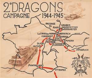
2° Dragons Campagne 1944 - 1945.
sold
- Digital Map Information
- Suitable for large format printing
- File Size: 20.89 MB
- File Type: ZIP / TIFF
- ICC color profile embedded
- Delivered instantly via download link
This is a c. 1945 route map of the French 2nd Dragoon Regiment (2e Régiment de Dragons) in Western Europe during World War II. Such commemoratives route maps were published for many American regiments and divisions, but were not universally adopted by other Allied forces. We have occasionally seen British route maps, but comparable French maps, as here, are exceedingly rare. (more details)
Follow the 748th Field Artillery Battalion through the European Theater of Operations.
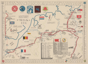
History of 748 F. A. Bn. in E.T.O.
sold
- Digital Map Information
- Suitable for large format printing
- File Size: 28.5 MB
- File Type: ZIP / TIFF
- ICC color profile embedded
- Delivered instantly via download link
This is a rare 1945 World War II pictorial route map of the 748th Field Artillery Battalion in the European Theater of Operations. The map follows the battalion from Liverpool, England, to Weissenburg, Germany, and marks its battles and alongside illustrations of landmarks and 'cultural moments' experienced by the soldiers. (more details)
Tank Destroyers during World War II.
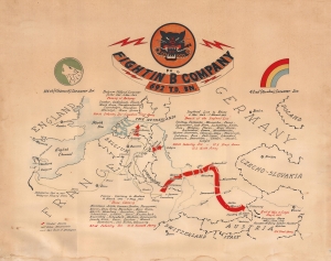
Fightin' 'B' Company 692 T.D. Bn.
sold
- Digital Map Information
- Suitable for large format printing
- File Size: 22.74 MB
- File Type: ZIP / TIFF
- ICC color profile embedded
- Delivered instantly via download link
This is a c. 1945 World War II unit route map of Company B, 692nd Tank Destroyer Battalion, in Europe. The map follows Company B from its September 26, 1944 debarkation in Europe through France, Belgium, and Germany until May 8, 1945, V-E Day, the end of the war in Europe. (more details)
An American Engineer Battalion in WWII.
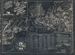
Beaver Trails. History of the 178th Engineer Combat Battalion 23 July 1943 to 23 Sept. 1945.
sold
- Digital Map Information
- Suitable for large format printing
- File Size: 23.01 MB
- File Type: ZIP / TIFF
- ICC color profile embedded
- Delivered instantly via download link
This is a 1945 178th Engineer Combat Battalion World War II blackprint pictorial route map of Europe created by LeRoy Gensler. The map highlights the battalion's actions in combat, including during the Battle of the Bulge and building a bridge across the Rhine River. (more details)
German propaganda that ignores defeats on the Eastern Front.
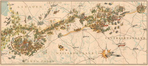
Mit Uns Im Osten.
sold
- Digital Map Information
- Suitable for large format printing
- File Size: 54.85 MB
- File Type: ZIP / TIFF
- ICC color profile embedded
- Delivered instantly via download link
This is a 1942 Leo Faller World War II pictorial route map of the German 5th Infantry Division on the Eastern Front. The map is almost certainly a German propaganda piece meant to glamorize the wildly unpopular and, by January 1942, when it was published, failing Operation Barbarossa. (more details)
Follow the 32nd Armored Regiment across Europe during World War II.
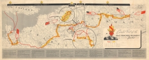
Combat Trail of the 32nd Armored Regiment Third Armored Spearhead Division.
sold
- Digital Map Information
- Suitable for large format printing
- File Size: 18.96 MB
- File Type: ZIP / TIFF
- ICC color profile embedded
- Delivered instantly via download link
This is a 1945 World War II pictorial unit route map of the 32nd Armored Regiment in Europe. The map illustrates the Regiment's movements from its departure from England until it was taken off the line for the final time in late April 1944. (more details)
Follow an ammunition supply battalion across Europe.
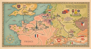
262 Ordnance Battalion (AM) in the European Theatre of Operations. Lt. Col. H.C. Holman Commanding.
sold
- Digital Map Information
- Suitable for large format printing
- Full resolution TIFF file
- ICC color profile embedded
- Delivered instantly via download link
This is an artistic World War II pictorial route map highlighting the campaign of the 262nd Ordnance Ammunition Battalion drawn by Walter Leonard. (more details)
Engineer Battalion in WWII.
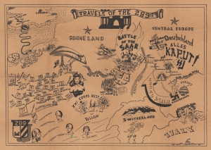
Travels of the 289th.
sold
- Digital Map Information
- Suitable for large format printing
- Full resolution TIFF file
- ICC color profile embedded
- Delivered instantly via download link
This is a 1945 John Louis Bartolomeo World War II pictorial route map of the 289th Combat Engineer Battalion in Western Europe. Pictorial vignettes highlight battles, the defeat of Germany, occupation duty, encounters with women, and parties. (more details)
The 188th from England to victory in Germany.
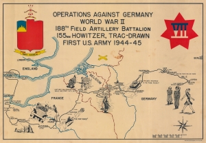
Operations Against Germany World War II 188th Field Artillery Battalion 155mm Howitzer, Trac-Drawn First U.S. Army 1944 - 45.
sold
- Digital Map Information
- Suitable for large format printing
- File Size: 17.66 MB
- File Type: ZIP / TIFF
- ICC color profile embedded
- Delivered instantly via download link
This is a 1945 188th Field Artillery Battalion World War II Route Map of Europe. The map traces the battalion's movements during the war, marking important events, and providing comedic commentary on the experience. (more details)
World War II as experienced by the soldiers of the III Corps.
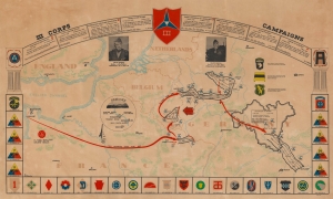
III Corps Campaigns.
sold
- Digital Map Information
- Suitable for large format printing
- File Size: 31.26 MB
- File Type: ZIP / TIFF
- ICC color profile embedded
- Delivered instantly via download link
This is a 1945 Al Beaudry III Corps World War II pictorial route map of Europe. Highlighting the corps' movements, its successes, and its assigned divisions, this map details wartime events experienced by thousands of soldiers. (more details)
Follow the 5th Armored Division across Europe during World War II.
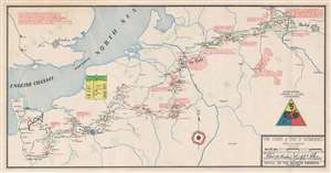
The Trek of the 5th Armored.
sold
- Digital Map Information
- Suitable for large format printing
- Full resolution TIFF file
- ICC color profile embedded
- Delivered instantly via download link
Drafted by Robert G. Buchan, this is an all-business history of the 5th Armored Division’s drive across Europe. Red lines mark the division’s progress, sometimes day-to-day, naming towns and cities visited. Information about the division’s movements, such as their claim to have been the first American division in Germany, as well as the first division to breach the Siegfried Line, are in red. Dates when the division was pulled off the line and when they crossed the Rhine River are also given. Exhibiting an impressive dedication to detail, the route is sometimes divided between the ‘CCA’ (Combat Command A), ‘CCB’ (Combat Command B) and ‘CCR’ (Combat Command Reserve or Headquarters). Comparable in size to brigades or regiments, combat commands were newly established within the 4th, 5th, and 6th Armored Divisions in 1943. The 2nd and 3rd Armored Divisions maintained their original organization until the end of the war. (more details)