
Bollmann, Herman (sold)

Herman Bollmann (1911 - 1971) was a German cartographer and map maker active from roughly 1940 to 1970. Before World War II, Bollmann was a well-known woodcarver and engraver based in Braunschweig, Germany. Following the war, Bollmann developed a reputation as a printer of unique three-dimensional maps. Working over a period of 25 years, Bollmann established a reputation as an artistic cartographer, producing over 39 unique projections of various cities in Europe and America. Bollmann revived the 19th-century cartographic technique known as Vogelschaukarten, a way of making three-dimensional axonometric projections. Bollmann and his team relied heavily on aerial cartography to compose distinctive cartographic masterpieces that are coveted by collectors all over the world.
The Postwar revitalization of Hannover by one of the great 20th century cartographers.
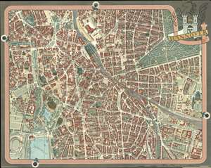
This is Hermann Bollmann’s 1959 map of Hanover, Germany. Executed in Bollmann’s characteristic axonometric projection, this bird’s eye view (or as Bollmann called it, ‘helicopter perspective’) combines accurate mapmaking with the enhancement of both aerial and ground photography to create a clear yet realistic view of the city. Bollmann began producing such views in 1949, and by this time was approaching the prime of his career. Documenting the Cost of War, and the ‘German Economic Miracle’ Bollmann’s first post-war city plans he named Trümmerkarte, or ‘Debris Maps,’ for their focus was the damage done by Allied air raids during the war; his first of these was Brunswick, printed in 1949. These views showed the shells of bombed-out buildings, and blocks flattened by the raids. The 1955 Hannover, too, chronicled the war damage the city suffered. So it is notable the extent to which this 1959 edition of the same map records the reconstruction of the city. This 1959 edition was not just a reprinting. The view was updated, with new roads and construction appearing all over the city. Palaces like the Leineschloss, and Neustadter and Paulus Kirchen are shown rebuilt. Some blocks shown almost completely cleared in 1955 - such as the one south of Ostermannstrasse, and the neighborhoods directly northeast of the railway station - in 1959 show new buildings: apartments, offices, schools, and the notionally iconic VW Tower overlooking the Hamburger Allee – itself a boulevard which does not exist on the 1955 view. The view includes, in red dotted line, the prospective route of the equally-new Berliner Allee, which now merges into the Hamburger Allee. Other traces of the war - for example, the 1955 has barracks appearing on the grounds of the Schutzen Fest-Platz, site of Hanover’s annual marksman’s fun fair; on the 1959 these are removed leaving the fields clear, with only the existing Festival offices at the entrance to the Fest-Platz visible. Likewise at the corner of Klagesmarkt and Theodorstrasse, a block of barrack-style housing with a guard post entry appears on the 1955 view, on a lot which is clear on the 1959.
The revitalized content of the map is accompanied by a refreshing of the colors used in printing this 1959 edition, which is overall a richer and brighter palette than that used on 1955 map. The title of the map is shown on a banner in the upper right, and is surmounted by the arms of the city - which, as a dedicated map collector ought to know from the famous Bunting world map, are a cloverleaf. (more details)
The revitalized content of the map is accompanied by a refreshing of the colors used in printing this 1959 edition, which is overall a richer and brighter palette than that used on 1955 map. The title of the map is shown on a banner in the upper right, and is surmounted by the arms of the city - which, as a dedicated map collector ought to know from the famous Bunting world map, are a cloverleaf. (more details)
One of the crowning glories of modern urban cartography, in a superb example of the first issue.
New York Map-Guide
sold
- Digital Map Information
- Suitable for large format printing
- File Size: 110.68 MB
- File Type: ZIP / TIFF
- ICC color profile embedded
- Delivered instantly via download link
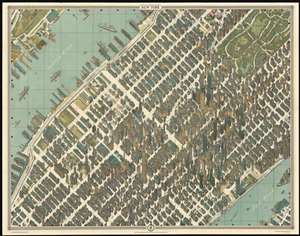
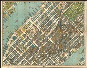
The high point of urban cartographic art – the 1963 Bollmann axonometric map of midtown Manhattan, in its first issue. This distinctive view presents the area at the stylistic peak of the skyscraper era: over half of the world's skyscrapers standing at the time appear within the bounds of this view.
Bollmann created an image of great, apparent precision by employing subtle distortion and exaggeration to emphasize scale and clarity. The entire work was first drawn by hand, and its preparation boasted the use of over 67,000 photographs, 17,000 of which were aerial. Bollmann widened the streets to keep the image uncluttered; his view dispenses with perspective to maintain a uniform scale for all the buildings and allow comparison of size. The result captures this mighty concentration of towers, presenting each with its uniquely recognizable profile: the iconic Empire State building, the graceful Art Deco curves of the Chrysler building, the sleek blade of the United Nations, and the ultra-modern helicopter pad of the Pan Am building. The verso of the map is a detailed map of the five boroughs; the map dates itself by the presence of New York International Airport, Idlewild Terminal. Both the 1963 and 1964 American-printed editions replace this verso map with a map of the subway system. (more details)
Bollmann created an image of great, apparent precision by employing subtle distortion and exaggeration to emphasize scale and clarity. The entire work was first drawn by hand, and its preparation boasted the use of over 67,000 photographs, 17,000 of which were aerial. Bollmann widened the streets to keep the image uncluttered; his view dispenses with perspective to maintain a uniform scale for all the buildings and allow comparison of size. The result captures this mighty concentration of towers, presenting each with its uniquely recognizable profile: the iconic Empire State building, the graceful Art Deco curves of the Chrysler building, the sleek blade of the United Nations, and the ultra-modern helicopter pad of the Pan Am building. The verso of the map is a detailed map of the five boroughs; the map dates itself by the presence of New York International Airport, Idlewild Terminal. Both the 1963 and 1964 American-printed editions replace this verso map with a map of the subway system. (more details)
Billionaire's Row When It Was Still Cool.
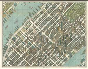
The pinnacle of urban cartographic art - this is the 1962 Bollmann axonometric map of midtown Manhattan, in its first issue. This distinctive view presents the area at the stylistic peak of the skyscraper era: over half of the world's skyscrapers standing at the time appear within the bounds of this view.
Bollmann created an image of great, apparent precision by employing subtle distortion and exaggeration to emphasize scale and clarity. The entire work was first drawn by hand, and its preparation boasted the use of over 67,000 photographs, 17,000 of which were aerial. Bollmann widened the streets to keep the image uncluttered; his view dispenses with perspective to maintain a uniform scale for all the buildings and allow comparison of size. The result captures this mighty concentration of towers, presenting each with its uniquely recognizable profile: the iconic Empire State building, the graceful Art Deco curves of the Chrysler building, the sleek blade of the United Nations, and the ultra-modern helicopter pad of the Pan Am building. The verso of the map is a detailed map of the five boroughs; the map dates itself by the presence of New York International Airport, Idlewild Terminal. Both the 1963 and 1964 American-printed editions replace this verso map with a map of the subway system. (more details)
Bollmann created an image of great, apparent precision by employing subtle distortion and exaggeration to emphasize scale and clarity. The entire work was first drawn by hand, and its preparation boasted the use of over 67,000 photographs, 17,000 of which were aerial. Bollmann widened the streets to keep the image uncluttered; his view dispenses with perspective to maintain a uniform scale for all the buildings and allow comparison of size. The result captures this mighty concentration of towers, presenting each with its uniquely recognizable profile: the iconic Empire State building, the graceful Art Deco curves of the Chrysler building, the sleek blade of the United Nations, and the ultra-modern helicopter pad of the Pan Am building. The verso of the map is a detailed map of the five boroughs; the map dates itself by the presence of New York International Airport, Idlewild Terminal. Both the 1963 and 1964 American-printed editions replace this verso map with a map of the subway system. (more details)
One of the crowning glories of modern cartography
New York Map-Guide
sold
- Digital Map Information
- Suitable for large format printing
- File Size: 69.4 MB
- File Type: ZIP / TIFF
- ICC color profile embedded
- Delivered instantly via download link
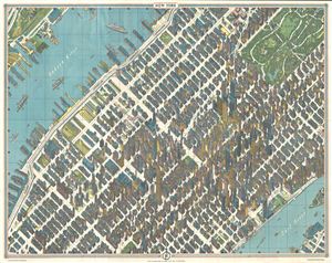
One of the greatest cartographic feats of all time, this 1963 axonometric ('bird's eye view') map of New York City was the first such since 1866. The technique dates back to the 15th century, and developed in Germany into a fully flowered cartographic art form ... (more details)
Aesthetic pinnacle of the skyscraper era.
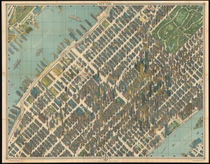
This is the 1962 Bollmann axonometric map of midtown Manhattan, in its 1963 issue. This distinctive view presents the heart of New York City at the stylistic peak of the skyscraper era: over half of the world's skyscrapers standing at the time appear within the bounds of this view. (more details)
Aesthetic pinnacle of the skyscraper era.
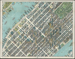
This is the 1962 Bollmann axonometric map of midtown Manhattan, in its 1963 issue. This distinctive view presents the heart of New York City at the stylistic peak of the skyscraper era: over half of the world's skyscrapers standing at the time appear within the bounds of this view. (more details)
Aesthetic pinnacle of the skyscraper era.
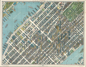
This is the 1962 Bollmann axonometric map of midtown Manhattan, in its 1963 issue. This distinctive view presents the heart of New York City at the stylistic peak of the skyscraper era: over half of the world's skyscrapers standing at the time appear within the bounds of this view. (more details)
Unsanctioned Jet Age Expo.
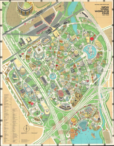
This is Herman Bollmann's 1964 pictorial bird's-eye view of the grounds of the 1964 New York World's Fair. Despite the contentious origins and questionable financing of the fair, it was fondly remembered by attendees for its distinctive Space Age futuristic aesthetic. (more details)
One of the crowning glories of modern cartography
New York Map-Guide
sold
- Digital Map Information
- Suitable for large format printing
- File Size: 152.61 MB
- File Type: ZIP / TIFF
- ICC color profile embedded
- Delivered instantly via download link
The high point of 20th century urban cartographic art – the 1964 Bollmann axonometric map of midtown Manhattan – presenting the area at the stylistic peak of the skyscraper era. Bollmann created an image of great, apparent precision by employing subtle distortion and exaggeration to emphasize scale and clarity. The entire work was first drawn by hand, and its preparation boasted the use of over 67,000 photographs, 17,000 of which were aerial. Bollmann widened the streets to keep the image uncluttered; his view dispenses with perspective to maintain a uniform scale for all the buildings and allow comparison of size. The result captures the highest concentration of skyscrapers in the world of its day, presenting each with its uniquely recognizable profile: the iconic Empire State building, the graceful Art Deco curves of the Chrysler building, the sleek blade of the United Nations, and the ultra-modern helicopter pad of the Pan Am building. The verso of the map is a detailed and large-scale subway map of the five boroughs, showing the three subway lines in operation at the time: the IRT, the BMT and the IND. Another distinction between this and the earlier issues is the notation of the 1965 world's fair, and the renaming of Idlewild International Airport to JFK. (more details)
Aesthetic pinnacle of the skyscraper era.
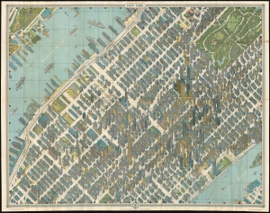
This is the 1962 Bollmann axonometric map of midtown Manhattan, in its 1964 issue. This distinctive view presents the area at the stylistic peak of the skyscraper era: over half of the world's skyscrapers standing at the time appear within the bounds of this view. (more details)
A wonderful metallic pictorial bird's eye view of Jerusalem published in Haifa.
Jerusalem.
sold
- Digital Map Information
- Suitable for large format printing
- File Size: 60.93 MB
- File Type: ZIP / TIFF
- ICC color profile embedded
- Delivered instantly via download link
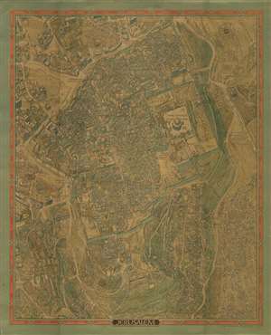
This is a stunning 1969 Herman Bollmann bird's eye view pictorial map of Jerusalem printed with an extraordinary metallic ink. The map depicts the city from Yemin Moshe to the Mount of Offense and from the Rockefeller Museum to Shim'a. Buildings throughout Jerusalem are illustrated in detail, including the Dome of the Rock, the Western Wall, the Al-Aqsa Mosque, the Church of the Redeemer, and the Church of the Holy Sepulcher in the Old City, which is surrounded by its ancient walls. Numerous gates in the walls are identified. Myriad small buildings are illustrated within the Old City, and the Jewish Quarter, Christian Quarter, Muslim Quarter, and Armenian Quarter are each labeled. Buildings and other sites outside the Old City are also illustrated and labeled, including the Church of the Tomb of the Virgin, Gethsemane, David's Tomb, the Church of Dormition, and the Yemin Moshe Synagogue. The Catholic, Prostestant, Jewish, and Muslim cemeteries are all identified. Numerous streets are identified. The whole is surrounded by a border bearing the name of Jerusalem translated into sixteen different languages. (more details)
The first pictorial map made in Israel?
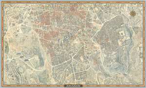
This is a stunning 1969 first edition Herman Bollmann bird's eye view pictorial map of Jerusalem. The map depicts the city from the Old City to Hebrew University. Buildings throughout Jerusalem are illustrated in detail, including the Dome of the Rock, the Western Wall, the Al-Aqsa Mosque, the Church of the Redeemer, and the Church of the Holy Sepulcher in the Old City, which is surrounded by its ancient walls. Numerous gates in the walls are identified. Myriad small buildings are illustrated within the Old City, and the Jewish Quarter, Christian Quarter, Muslim Quarter, and Armenian Quarter are each labeled. Buildings and other sites outside the Old City are also illustrated and labeled, including the Church of the Tomb of the Virgin, Gethsemane, David's Tomb, the Church of Dormition, and the Yemin Moshe Synagogue. The Catholic, Protestant, Jewish, and Muslim cemeteries are all identified. Numerous streets are identified. The whole is surrounded by a border bearing the name of Jerusalem translated into sixteen different languages. (more details)
A stunning pictorial map of Jerusalem.
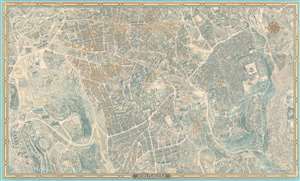
This is a 1969 first edition Herman Bollmann bird's eye view pictorial map of Jerusalem. The map depicts the city from the Old City to Hebrew University. Buildings throughout Jerusalem are illustrated in detail, including the Dome of the Rock, the Western Wall, the Al-Aqsa Mosque, the Church of the Redeemer, and the Church of the Holy Sepulcher in the Old City, which is surrounded by its ancient walls. Numerous gates in the walls are identified. Myriad small buildings are illustrated within the Old City, and the Jewish Quarter, Christian Quarter, Muslim Quarter, and Armenian Quarter are each labeled. Buildings and other sites outside the Old City are also illustrated and labeled, including the Church of the Tomb of the Virgin, Gethsemane, David's Tomb, the Church of Dormition, and the Yemin Moshe Synagogue. The Catholic, Protestant, Jewish, and Muslim cemeteries are all identified. Numerous streets are labeled. The whole is surrounded by a border bearing the name of Jerusalem translated into sixteen different languages. (more details)
Scarce View of Jerusalem with metallic printing.
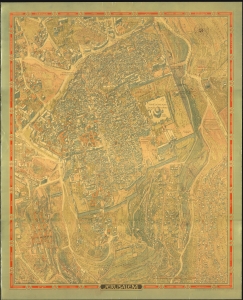
This is a striking 1969 Herman Bollmann bird's-eye view pictorial map of Jerusalem printed with metallic ink. (more details)
Stunning pictorial map of Jerusalem.
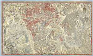
This is a 1972 second edition Herman Bollmann bird's-eye view pictorial map of Jerusalem accompanied by the original mailing tube and key - these latter two items being of exceptional rarity. (more details)