

Turquie Europe 1835.
sold
- Digital Map Information
- Suitable for large format printing
- Full resolution TIFF file
- ICC color profile embedded
- Delivered instantly via download link
This is a beautiful 1835 hand colored map of Turkey or the Ottoman Empire as it extended into Europe during the early 19th century. Includes all of modern day Greece and the Balkans. All text is in ... (more details)

Carte de la Grece en de L’Archipel 1834.
sold
- Digital Map Information
- Suitable for large format printing
- Full resolution TIFF file
- ICC color profile embedded
- Delivered instantly via download link
This is a beautiful 1834 hand colored map of Greece including very good detail of the Archipelago. Includes Crete or Candia. All text is in ... (more details)

Prusse 1834.
sold
- Digital Map Information
- Suitable for large format printing
- Full resolution TIFF file
- ICC color profile embedded
- Delivered instantly via download link
This is a beautiful 1834 hand colored map of Northern Germany or Prussia. Includes parts of Denmark and the Rhine region. All text is in ... (more details)

Danemark 1833.
sold
- Digital Map Information
- Suitable for large format printing
- Full resolution TIFF file
- ICC color profile embedded
- Delivered instantly via download link
This is a beautiful 1833 hand colored map of Danemark (Denmark). Includes a beautiful inset of Iceland and a smaller inset of the Faroe ... (more details)

Mitchell's Map of Peru, Ecuador, Venezuela, Columbia and Argentina.
sold
- Digital Map Information
- Suitable for large format printing
- File Size: 3.06 MB
- File Type: ZIP / TIFF
- ICC color profile embedded
- Delivered instantly via download link
This hand colored map is a steel plate engraving, dating to 1860 by the legendary American mapmaker Samuel Augustus Mitchell. It ... (more details)

Asie Mineure Ancienne.
sold
- Digital Map Information
- Suitable for large format printing
- Full resolution TIFF file
- ICC color profile embedded
- Delivered instantly via download link
This is a beautiful 1837 hand colored map depicts Asia Minor or what is today Turkey as it appeared in Ancient time. This region ... (more details)

Afrique Ancienne.
sold
- Digital Map Information
- Suitable for large format printing
- Full resolution TIFF file
- ICC color profile embedded
- Delivered instantly via download link
This is a beautiful 1837 hand colored map northern Africa in Ancient times. Depicts the various ancient kingdoms as well as ... (more details)

Barbarie 1833.
sold
- Digital Map Information
- Suitable for large format printing
- Full resolution TIFF file
- ICC color profile embedded
- Delivered instantly via download link
This is a beautiful 1833 hand colored map of Northern Africa and the Mediterranean – the region known as Barbary. ... (more details)

Johnson’s Michigan and Wisconsin.
sold
- Digital Map Information
- Suitable for large format printing
- File Size: 9.29 MB
- File Type: ZIP / TIFF
- ICC color profile embedded
- Delivered instantly via download link
This is a beautifully hand colored 1863 lithograph map of Michigan and Wisconsin. Includes a beautiful inset ... (more details)

Johnson’s Michigan and Wisconsin.
sold
- Digital Map Information
- Suitable for large format printing
- File Size: 4.19 MB
- File Type: ZIP / TIFF
- ICC color profile embedded
- Delivered instantly via download link
This is a beautifully hand colored 1861 lithograph map of Michigan and Wisconsin. Includes a beautiful inset ... (more details)
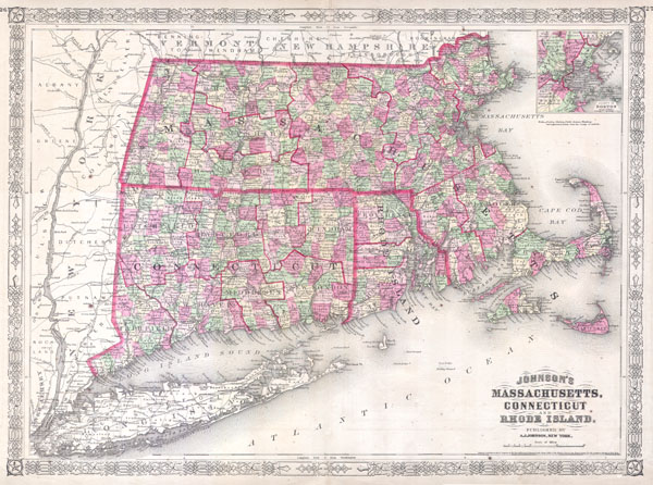
Johnson’s Massachusetts, Connecticut and Rhode Island.
sold
- Digital Map Information
- Suitable for large format printing
- File Size: 4.96 MB
- File Type: ZIP / TIFF
- ICC color profile embedded
- Delivered instantly via download link
This is a beautifully hand colored 1864 lithograph map of Massachusetts, Connecticut, Rhode Island and Long ... (more details)

Maine
sold
- Digital Map Information
- Suitable for large format printing
- File Size: 5.51 MB
- File Type: ZIP / TIFF
- ICC color profile embedded
- Delivered instantly via download link
This is an unusual issue of the Colton's Maine map prepared for the Maine State Year Book. Though this map ... (more details)

Preliminary Sketch of the Sea Coast of Virginia from Gargathy Inlet to Gr. Machipongo Inlet.
sold
- Digital Map Information
- Suitable for large format printing
- DPI: 300
- File Size: 1.84 MB
- File Type: ZIP / TIFF
- ICC color profile embedded
- Delivered instantly via download link
Offered is a U.S. Coast Survey map or chart of the Virginia coastline from Gartathy Inlet to Gr. Machipongo ... (more details)
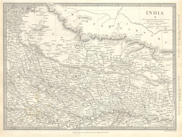
India X.
sold
- Digital Map Information
- Suitable for large format printing
- Full resolution TIFF file
- ICC color profile embedded
- Delivered instantly via download link
This map is a steel plate engraving, dating to 1838 and published by the S.D.U.K. or 'The Society for the ... (more details)

India III.
sold
- Digital Map Information
- Suitable for large format printing
- Full resolution TIFF file
- ICC color profile embedded
- Delivered instantly via download link
This map is a steel plate engraving, dating to 1838 and published by the S.D.U.K. or 'The Society for the ... (more details)

Johnson’s Japan, Nippon, Kiusiu, Sikok, Yesso and the Japanese Kuriles.
sold
- Digital Map Information
- Suitable for large format printing
- File Size: 2.72 MB
- File Type: ZIP / TIFF
- ICC color profile embedded
- Delivered instantly via download link
This is a beautifully hand colored 1864 lithograph map of the Japan. There are insets of the bay of ... (more details)

Asie.
sold
- Digital Map Information
- Suitable for large format printing
- File Size: 2.99 MB
- File Type: ZIP / TIFF
- ICC color profile embedded
- Delivered instantly via download link
This hand colored map of Asia is a steel plate engraving, dating to 1875 by the well regarded French ... (more details)
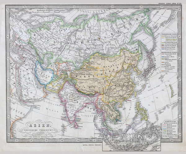
Asien Politische Ubersicht.
$100.00
Acquire
- Digital Map Information
- Suitable for large format printing
- File Size: 3.84 MB
- File Type: ZIP / TIFF
- ICC color profile embedded
- Delivered instantly via download link
This fascinating 1862 map by Justus Perthes and Stieler depicts the continent of Asia. Unlike other ... (more details)
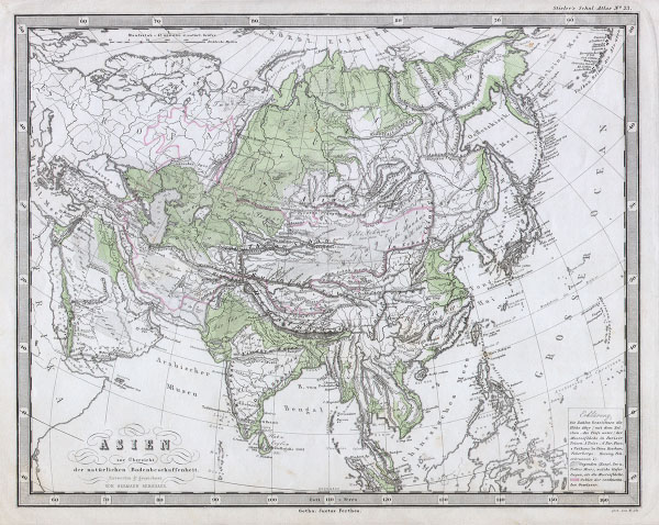
Asien.
$100.00
Acquire
- Digital Map Information
- Suitable for large format printing
- File Size: 3.47 MB
- File Type: ZIP / TIFF
- ICC color profile embedded
- Delivered instantly via download link
This fascinating 1862 map by Justus Perthes and Stieler depicts the physical geography of the ... (more details)

Carte de la Siberie ou Russie d’Asie Septentrionale. 1836..
sold
- Digital Map Information
- Suitable for large format printing
- Full resolution TIFF file
- ICC color profile embedded
- Delivered instantly via download link
This unusual 1836 map by V. A. Malte-brun depicts Russia in Asia or Siberia. Depicts from ... (more details)