
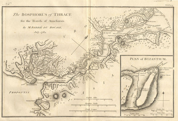
Bosphorus and the city of Byzantium.
sold
- Digital Map Information
- Suitable for large format printing
- Full resolution TIFF file
- ICC color profile embedded
- Delivered instantly via download link
This lovely map, depicting the Bosphorus and the city of Byzantium, was prepared by M. Barbie de Bocage in 1784 for the 'Travels of Anarcharsis.' The map shows the narrow naval passage from the Propontis (Sea of Marmara) to the Pontus Euxinus (Black Sea). There ... (more details)

Carte de Perse…
sold
- Digital Map Information
- Suitable for large format printing
- Full resolution TIFF file
- ICC color profile embedded
- Delivered instantly via download link
This remarkable map of Tartary, or Central Asia from the Black Sea to Tibet, by the mapmaker Rigobert Bonne was made in 1780. Bonne was the successor to Bellin as head Engineer of the French Hydrographe del la Marine Department. Includes Iraq, Kuwait, ... (more details)

Greenburgh Westchester Co. N.Y.
sold
- Digital Map Information
- Suitable for large format printing
- File Size: 3.06 MB
- File Type: ZIP / TIFF
- ICC color profile embedded
- Delivered instantly via download link
This is the scarce Greenburgh sheet from Beers' 1867 Atlas of Westchester County, New York. When this map was produced 'Greenburgh' consisted of what is today the central Westchester County. Includes White Plains, Scarsdale, Hastings, Dobbs Ferry, ... (more details)

(H No. 5) Preliminary Reconnaissance of the Grand Pass the Entrance to Timballier Bay, Louisiana.
sold
- Digital Map Information
- Suitable for large format printing
- DPI: 300
- File Size: 1.82 MB
- File Type: ZIP / TIFF
- ICC color profile embedded
- Delivered instantly via download link
A rare hand colored 1853 costal chart of the Entrance to Timbalier Bay, Louisiana. Features East and West Timballier Island, depth soundings, and sailing notes. Published under the supervision of A. D. Bache for the 1853 Report of the ... (more details)

(E No. 3) Preliminary Chart of North Edisto River.
sold
- Digital Map Information
- Suitable for large format printing
- DPI: 300
- File Size: 3.14 MB
- File Type: ZIP / TIFF
- ICC color profile embedded
- Delivered instantly via download link
A rare hand colored 1853 costal chart of South Carolina's North Edisto River. Features St. John's Colleton, Seabrook's Island, Legaro's House, the town of Rockville, and numerous plantations and private farms. Includes detailed ... (more details)

(K No. 2) Preliminary Survey of Shoalwater Bay Washington.
sold
- Digital Map Information
- Suitable for large format printing
- DPI: 300
- File Size: 3.38 MB
- File Type: ZIP / TIFF
- ICC color profile embedded
- Delivered instantly via download link
A rare hand colored 1853 costal chart of Shoalwater Bay, Washington. Includes impressive detail regarding oyster beds, banks, sand bars, and depth soundings. Hydrography by James Alden. Published under the supervision of A. D. ... (more details)

(Sketch A No. 3) Minots Ledge Off Boston Harbor.
sold
- Digital Map Information
- Suitable for large format printing
- DPI: 300
- File Size: 4.71 MB
- File Type: ZIP / TIFF
- ICC color profile embedded
- Delivered instantly via download link
A rare hand colored 1853 coastal chart of the Minots Ledge, just off Boston Harbor, Massachusetts. Features The Cohasset Salt Works, Old Harbor, Brig Harbor, The Glades, Cohasset Harbor, and various islands . Published under the ... (more details)

(Sketch 1 No. 4) Preliminary Chart of San Luis Pass Texas.
sold
- Digital Map Information
- Suitable for large format printing
- DPI: 300
- File Size: 4.53 MB
- File Type: ZIP / TIFF
- ICC color profile embedded
- Delivered instantly via download link
A rare hand colored 1853 costal chart of San Luis Pass or the entrance to Galveston harbor, Texas. Features Peninsula Point, Follet's Ferry, San Luis Island, Mud Island and Galveston Island. There is a otel indicated on San Luis ... (more details)

Town of Yonkers Westchester Co. N.Y.
sold
- Digital Map Information
- Suitable for large format printing
- File Size: 3.09 MB
- File Type: ZIP / TIFF
- ICC color profile embedded
- Delivered instantly via download link
This is the scarce Yonkers sheet from Beers' 1867 Atlas of Westchester County, New York. When this map was produced 'Yonkers' consisted of what is today the Bronx, modern day Yonkers, and other communities as far north as ... (more details)

Mississippi River from Cairo Illinois to St. Mary’s Missouri in VI Sheets. Reconnaissance for the use of the Mississippi Squadron under the command of Acting Rear Admiral S.P.L.E.E, U.S.N. By the part of E. H. Gerdes, Assistant; assigned by A.D. Bache, Supdt. United States Coast Survey.
sold
- Digital Map Information
- Suitable for large format printing
- File Size: 5 MB
- File Type: ZIP / TIFF
- ICC color profile embedded
- Delivered instantly via download link
This is a beautiful 1865 United States Costal Survey chart or map of a sinuous part of the Mississippi River around Cairo, Illinois near the branching off of the Ohio River. Sheet one of a six sheet set depicting the ... (more details)

Mississippi River 78 to 98 miles above Cairo, Illinois.
sold
- Digital Map Information
- Suitable for large format printing
- File Size: 1.33 MB
- File Type: ZIP / TIFF
- ICC color profile embedded
- Delivered instantly via download link
This is a beautiful hand colored 1865 United States Costal Survey chart or map of a part of the Mississippi River between Illinois and Missouri, roughly between 78 and 96 miles above Cairo, Illinois. Sheet five of a ... (more details)

Mississippi River from Cairo Illinois to St. Mary’s Missouri in VI Sheets. Reconnaissance for the use of the Mississippi Squadron under the command of Acting Rear Admiral S.P.L.E.E, U.S.N. By the part of E. H. Gerdes, Assistant; assigned by A.D. Bache, Supdt. United States Coast Survey.
sold
- Digital Map Information
- Suitable for large format printing
- File Size: 2.32 MB
- File Type: ZIP / TIFF
- ICC color profile embedded
- Delivered instantly via download link
This is a beautifully hand colored 1865 United States Coast Survey chart or map of a sinuous part of the Mississippi River around Cairo, Illinois near the branching off of the Ohio River. Sheet one of a six sheet set ... (more details)
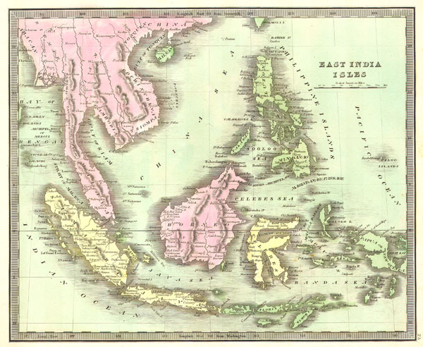
East India Isles
sold
- Digital Map Information
- Suitable for large format printing
- Full resolution TIFF file
- ICC color profile embedded
- Delivered instantly via download link
This hand colored map is a lithographic engraving of the East Indies, dating to 1842. Depicts all of Southeast Asia and the East Indies including Sumatra, Java, Borneo and the Philippines. On the mainland it shows ... (more details)
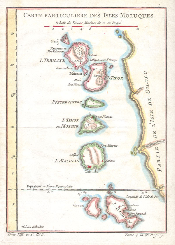
Carte Particuliere Des Isles Moluques.
$180.00
Acquire
- Digital Map Information
- Suitable for large format printing
- Full resolution TIFF file
- ICC color profile embedded
- Delivered instantly via download link
This beautiful hand colored map of the Moluques (also known as the Moluccas, Moluccan Islands or simply Maluku) was produced by the French Cartographer Jacques-Nicolas Bellin in 1760. Depicts the islands of Herij, ... (more details)

The Great Engineering Works of New York City.
sold
- Digital Map Information
- Suitable for large format printing
- File Size: 4.3 MB
- File Type: ZIP / TIFF
- ICC color profile embedded
- Delivered instantly via download link
Offered here is a rare edition of Scientific American Magazine issued to praise the great engineering projects of New York City. The front cover features a map of New York City's elevated train line – the ... (more details)

Turkey in Europe
sold
- Digital Map Information
- Suitable for large format printing
- Full resolution TIFF file
- ICC color profile embedded
- Delivered instantly via download link
This is a hand colored 1836 map of Greece & the Balkans under the rule of Turkey by John Cary. Includes the modern day states of Greece, Albania, Moldova, Bosnia, Croatia, Serbia, Bulgaria & Romania. ... (more details)

L'Etat de Venise avec les Duches de Mantoue et de Modene.
sold
- Digital Map Information
- Suitable for large format printing
- Full resolution TIFF file
- ICC color profile embedded
- Delivered instantly via download link
An attractive c. 1780 map of the Italian duchies of Venice, Mantua, and Modena. Covers as far south as Tuscany and Florence (Firenze) an as far north as Switzerland. Issued as plate number 56 for ... (more details)

Naples in Southern Italy.
sold
- Digital Map Information
- Suitable for large format printing
- Full resolution TIFF file
- ICC color profile embedded
- Delivered instantly via download link
This remarkable map of the province of Naples of southern Italy was made in 1780 by the mapmaker Rigobert Bonne. Towns, churches, cities and mountains are depicted as miniature representations of ... (more details)

MIssissippi River around Chester, Illinois.
sold
- Digital Map Information
- Suitable for large format printing
- File Size: 1.38 MB
- File Type: ZIP / TIFF
- ICC color profile embedded
- Delivered instantly via download link
This is a beautiful hand colored 1865 United States Costal Survey chart or map of a part of the Mississippi River around, Chester Illinois. Sheet six of a six sheet set depicting the Mississippi ... (more details)

Vancouver City and Island.
sold
- Digital Map Information
- Suitable for large format printing
- File Size: 1.68 MB
- File Type: ZIP / TIFF
- ICC color profile embedded
- Delivered instantly via download link
This beautiful and fascinating map Vancouver, Washington and Portland, Oregon was issued for the 1909 U.S. Coast & Geodetic Survey, under the supervision of Henry Gannett. The map is centered on ... (more details)