
Helping WWII military personnel get around Honolulu.

City of Honolulu. Territory of Hawaii. / Detailed Map and Guide of Honolulu and the Island of Oahu.
sold
- Digital Map Information
- Suitable for large format printing
- Full resolution TIFF file
- ICC color profile embedded
- Delivered instantly via download link
This is a January 1945 James Mann and George Armitage city plan or map of Honolulu, Oahu, Hawaii. Published near the end of World War II (1939 - 1945), the map provided military personnel stationed on the island with a practical guide to the city. It offers useful information about streets, hotels, and other locations, and suggests places of interest in Honolulu and Oahu. (more details)
Foundations of Terra Australis Incognita.
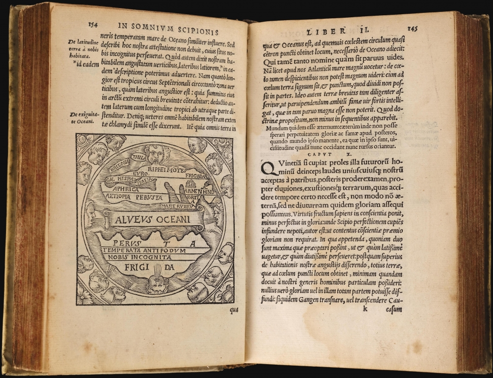
Macrobij Ambrosij Aurelij Theodosij, uiri consularis, and illustris : In Somnium Scipionis, lib. II. Saturnaliorum, lib. VII.
sold
This is a beautiful example of the 1548 Lyon edition of Macrobius' Saturnalia and his commentary on Cicero's Dream of Scipio, or Commentarii in Somnium Scipionis. The latter is one of the most cited works in the scholarship of the Middle Ages. In addition to its foundational role in transmitting Neoplatonism to the medieval world, this book was by the medieval world as the essential primer on cosmography. Macrobius' commentaries built on Cicero's cosmographical ideas and formalized them. Macrobius' analysis of Cicero placed his cosmography in the context of Claudius Ptolemy's astrological work. Through Macrobius' lens, the universe as understood by the ancient world, was embraced by philosophers, authors, and artists. His ideas extensively influenced the early geographers of the 16th century and were the source of early speculation on the existence of the undiscovered 'Terre Australis' (Southern Continent), an idea later adopted by Mercator and Ortelius. (more details)
Old Color Dutch 'Cartes-à-Figures' of Africa.

Africae nova descriptio. Auct: Guiljelmo Blaeuw.
sold
- Digital Map Information
- Suitable for large format printing
- Full resolution TIFF file
- ICC color profile embedded
- Delivered instantly via download link
This is a superb, original-color example of Willem Blaeu's 1617 atlas map of Africa, in the scarce second state from the 1635 edition of Blaeu's Theatrum Orbis Terrarum. It is one of the most desirable maps from the Dutch Golden Age of mapmaking. Norwich hailed it as 'one of the most decorative and popular of all the early maps of Africa.' (more details)
Internal WWII power struggle between the Japanese Navy and Army.

支那要圖 / [Map of China].
sold
- Digital Map Information
- Suitable for large format printing
- File Size: 214.01 MB
- File Type: ZIP / TIFF
- ICC color profile embedded
- Delivered instantly via download link
A large and unique product of Japan's full-scale invasion of China and the Japanese military's internal politics, this 1938 wall map was produced by the propaganda arm of the Imperial Japanese Navy. This enormous map is a propaganda vehicle related to the power struggle between the Japanese Army and Navy and their tussle for influence with the government, the Supreme War Council (軍事参議院), and the Emperor. The outcome of this struggle - in favor of the navy, ultimately came to define the Japanese Pacific War strategy. Of note, given this map's rarity and lack of publication information typical of the period (indicating both printing and publication dates), it is evident that this map was produced exclusively for internal naval use. (more details)
Brilliant example of a scarce, separately issued Long Island map.
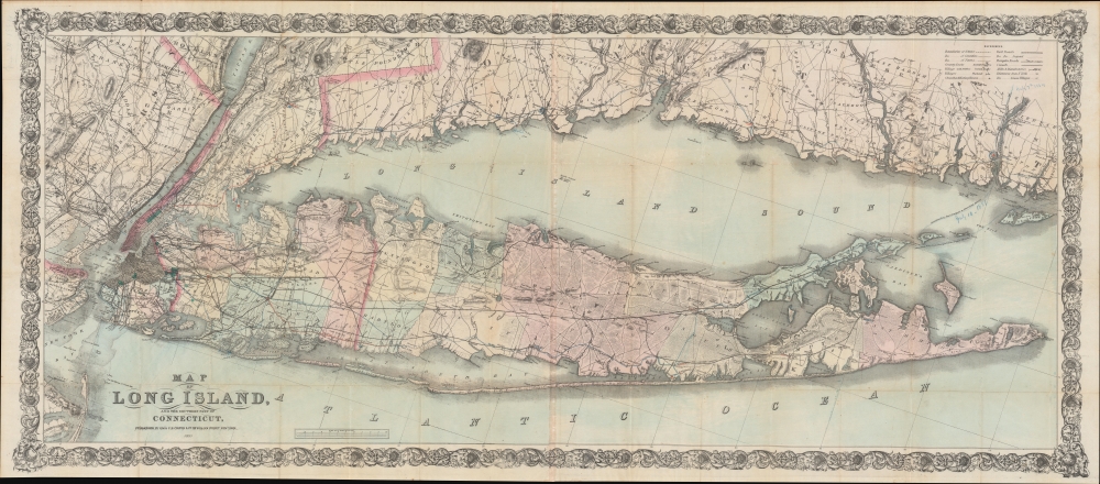
Map of Long Island, and the Southern Part of Connecticut.
sold
- Digital Map Information
- Suitable for large format printing
- File Size: 132.08 MB
- File Type: ZIP / TIFF
- ICC color profile embedded
- Delivered instantly via download link
This is a grand, scarce, separately issued 1880 Colton map of Long Island, Long Island Sound, Southern Connecticut, and the New York City region. It is among the largest and most dramatic maps of Long Island produced in the 19th century. (more details)
First German map of the state of California.

Karte des states California nach er officiellen Karte des State Surveyor General W. M. Eddy (approved and declared to be the official Map of the State of California by act of the Legislature, passed March 25th 1853) mit Berichtigung der Küste und einzelner Pässe nach den in den Jahren 1855-4 asusgeführten Künstenaufnahmen der V. St. Marine unde Recognoscirugen projectirter Eisenbahnlinien durch die Ingenieur Oficiere Gunnison, Beckwith, Williamson, u. a. gezeichnet von H. Kiepert Berlin 1856.
sold
- Digital Map Information
- Suitable for large format printing
- File Size: 10.6 MB
- File Type: ZIP / TIFF
- ICC color profile embedded
- Delivered instantly via download link
This is a rare 1856 H. Kiepert German edition of William M. Eddy's first official map of California. This is the first German-language map specifically of the state of California. (more details)
First detailed survey of the Grand Canyon.
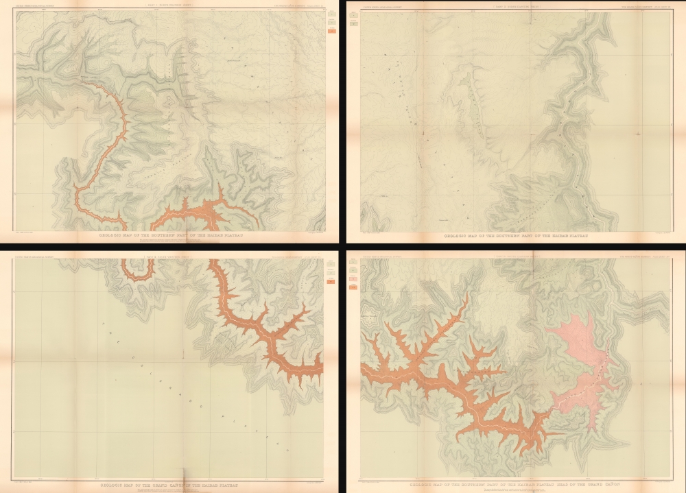
Geologic Map of the Southern Part of the Kaibab Plateau. / Geologic Map of the Southern Part of the Kaibab Plateau. / Geologic Map of the Grand Cañon in the Kaibab Plateau. / Geologic Map of the Southern part of the Kaibab Plateau - Head of the Grand Cañon.
$950.00
Acquire
- Digital Map Information
- Suitable for large format printing
- File Size: 101.44 MB
- File Type: ZIP / TIFF
- ICC color profile embedded
- Delivered instantly via download link
The first map of the Grand Canyon based on actual surveys - this is Clarence E. Dutton's 1882 four-part map of the Grand Canyon, published for the Atlas to Accompany the Monograph on the Tertiary History of the Grand Cañon District. (more details)
'Duty, Honor, Country'.

Map of West Point.
sold
- Digital Map Information
- Suitable for large format printing
- File Size: 9.18 MB
- File Type: ZIP / TIFF
- ICC color profile embedded
- Delivered instantly via download link
A rare 1844 map of the U.S. Military Academy at West Point, New York, by J. H. Colton. (more details)
Tourism and public transit in Rome.

Pianta Guida della Città di Roma: Veduta a volo d'uccello.
sold
- Digital Map Information
- Suitable for large format printing
- Full resolution TIFF file
- ICC color profile embedded
- Delivered instantly via download link
This is a scarce c. 1885 Romolo Bulla pictorial tourist map of Rome, Italy, representing the early development of Rome's tram system. (more details)
Japanese global perspective on the eve of World War II.

最新世界大地圖 / [Latest World Map].
sold
- Digital Map Information
- Suitable for large format printing
- Full resolution TIFF file
- ICC color profile embedded
- Delivered instantly via download link
This is a fascinating 1939 world map published by King magazine (キング) reflecting a Japanese perspective on geopolitics on the eve of World War II (1939 - 1945). The verso (back) includes two maps: one is a detailed map of China and Northeast Asia, where Japan was embroiled in a full-scale war, and the other is a map of Europe soon after the German occupation of the Sudetenland and the signing of the Munich Agreement. (more details)
Crucible of the Civil War.

Les champs de bataille du Rappahannock.
sold
- Digital Map Information
- Suitable for large format printing
- File Size: 26.28 MB
- File Type: ZIP / TIFF
- ICC color profile embedded
- Delivered instantly via download link
This 1890 Dumas Vorzet map displays eastern Virginia south of the Rappahannock River, the site of several important battles in the U.S. Civil War. It appeared in the scarce 1890 atlas volume of the French edition of Philippe d'Orléans' Histoire de la Guerre Civile en Amérique. (more details)
Stedman's rarest New Mexico map.

Battlefields of the Conquistadores in New Mexico.
sold
- Digital Map Information
- Suitable for large format printing
- Full resolution TIFF file
- ICC color profile embedded
- Delivered instantly via download link
An action-packed historical pictorial map of New Mexico, prepared in 1946 by Wilfred Stedman for the New Mexico State Tourist Bureau. From the Conquistadores to Pancho Villa, the map covers the history of conflict in New Mexico. (more details)
Pictorial history of New Mexico.

Recreational Map of New Mexico. The Land of Enchantment.
sold
- Digital Map Information
- Suitable for large format printing
- Full resolution TIFF file
- ICC color profile embedded
- Delivered instantly via download link
This is a 1952 Wilfred Stedman pictorial map of New Mexico. (more details)
Everything a Visitor could want in friendly New York City.

Hagstrom's Map of High Spots in New York.
sold
- Digital Map Information
- Suitable for large format printing
- File Size: 25.18 MB
- File Type: ZIP / TIFF
- ICC color profile embedded
- Delivered instantly via download link
This is a 1940 Hagstrom map of New York City. Highlighting sites throughout the city, many with small pictorial icons, the map caters to the casual sightseer by marking tourist sites and the more dedicated visitor in chronicling nightclubs and theaters. (more details)
New Horizons.

Routes of Pan American World Airways System / Your Clipper Trip.
sold
- Digital Map Information
- Suitable for large format printing
- Full resolution TIFF file
- ICC color profile embedded
- Delivered instantly via download link
A striking 1952 world map illustrating the routes of Pan American World Airways. A towering pioneer in the aviation industry, the company was among the first to offer reliable international passenger service and, by the 1950s, had the most developed global network of any American airline. (more details)
Richly-Detailed Southeast Asia.

Tabula Indiae Orientalis Emendata a F. de Wit.
sold
- Digital Map Information
- Suitable for large format printing
- File Size: 20.83 MB
- File Type: ZIP / TIFF
- ICC color profile embedded
- Delivered instantly via download link
This is Frederick de Wit's map of India, Southeast Asia, southern China, and the East Indies, including an early mapping of the north coast of Australia. (more details)
Rare Early Plate of an influential chart.

A Chart of the Coasts of Ireland and Part of England.
sold
- Digital Map Information
- Suitable for large format printing
- File Size: 21.64 MB
- File Type: ZIP / TIFF
- ICC color profile embedded
- Delivered instantly via download link
This is John Sellers' rare map of the coast of Ireland, published between 1690 and 1701. While the re-engraved Mount and Page version of this map can be found on the market, this precursor edition seldom appears and is often miscataloged. (more details)
Against the western expansion of slavery.
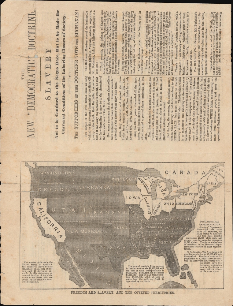
Freedom and Slavery, and the Coveted Territories.
sold
- Digital Map Information
- Suitable for large format printing
- Full resolution TIFF file
- ICC color profile embedded
- Delivered instantly via download link
This is a one-of-a-kind 1856 anti-slavery lettersheet map of the United States and pamphlet decrying the potential spread of slavery to include poor whites. It was distributed by the Young Men's Fremont and Dayton Central Union of the City of New-York, and describes the threat that future slavery might 'not be confined to the negro race, but to be made the universal condition of the laboring classes of society.' It reflects national anxiety regarding the presidential election of 1856 and the controversial passing of the Kansas-Nebraska Act. (more details)
Critical moment in U.S. History.

United States.
sold
- Digital Map Information
- Suitable for large format printing
- File Size: 15.13 MB
- File Type: ZIP / TIFF
- ICC color profile embedded
- Delivered instantly via download link
This is the scarce 1846 Thomas G. Bradford map of the United States. The map was published shortly before the outbreak of the Mexican-American War (1846 - 1848) and reflects three critical border disputes: the southwestern border between Mexico and the newly-admitted State of Texas (Congress voted to annex Texas on December 29, 1845), United States claims on Upper California, and the 54°40' dispute or Oregon Question in the Pacific Northwest. (more details)
Earliest map of Czechia, earliest map with a key!

Bohemiae Nova Descriptio Tabula.
sold
- Digital Map Information
- Suitable for large format printing
- Full resolution TIFF file
- ICC color profile embedded
- Delivered instantly via download link
This is Sebastian Münster's 1545 map of Bohemia, the earliest acquirable printed map of what is now the Czech Republic. This example appeared in the 1572 Latin edition of Münster's Cosmographia Universalis, a work notable for presenting to a broad lay audience many of the first printed maps based on contemporaneous surveys and toponymy, rather than data from classical sources. Munster's source for this map was Nicolaus Claudianus' 1518 map of Bohemia, which now exists in only one known surviving example. Munster's map is the only version of Claudianus' map available to the collector. (more details)