
Scouring South America for Gold.
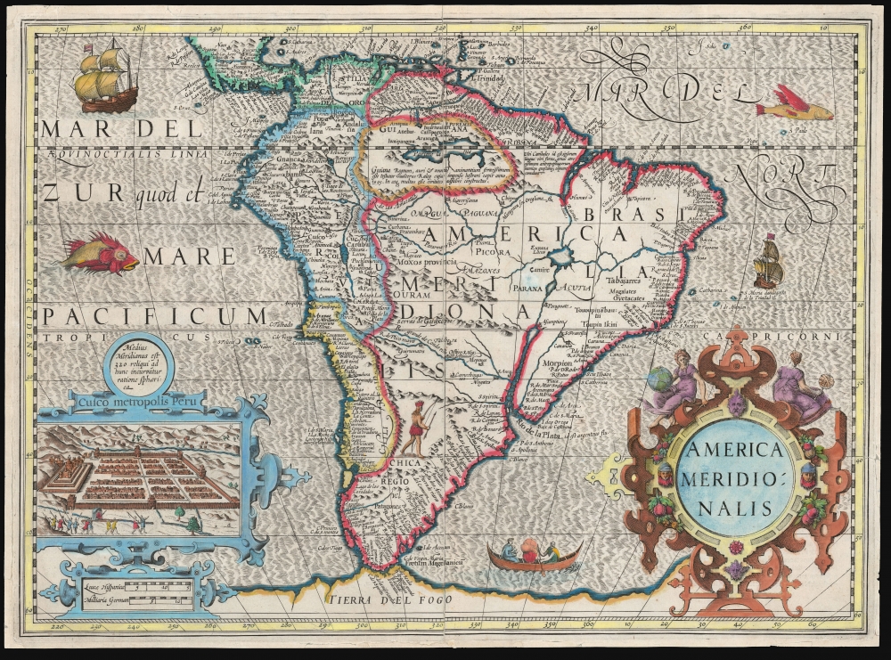
America Meridionalis.
sold
- Digital Map Information
- Suitable for large format printing
- File Size: 20.64 MB
- File Type: ZIP / TIFF
- ICC color profile embedded
- Delivered instantly via download link
This is a bright example of Jodocus Hondius' 1606 map of South America. The map extends from Central America and the West Indies to the speculative continent of Terra Australis just south of the Straits of Magellan. (more details)
Revealing Uzbek geography and toponymy.

Nova Maris Caspii et Regionis Usbeck cum Provincijs adjacentibus vera Delineatio.
sold
- Digital Map Information
- Suitable for large format printing
- File Size: 26.43 MB
- File Type: ZIP / TIFF
- ICC color profile embedded
- Delivered instantly via download link
This is Abraham Maas' map of Uzbekistan and the Caspian Region, edited by Johann Peter von Ghelen and published by Homann Heirs in 1735. It was the first map to show the results of Peter the Great's initiatives to chart this ill-understood frontier of the Russian Empire, and it is the first printed map specifically of the Uzbek region. Moreover, it incorporates the first published records of the indigenous toponymy east of the Caspian. (more details)
Congo's brutal history.

Congo Tabula Historica.
sold
This is a strikingly vivid c. 1955 James Thiriar historical pictorial map of the Congo. It presents a colorful but serious look at the harsh realities of Congo's brutal history, including inter-tribal warfare, slavery, and colonialism. (more details)
Selling Long Island to Manhattanites.
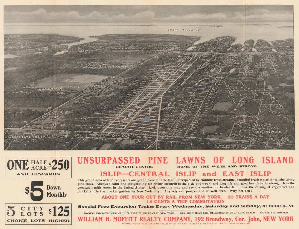
Unsurpassed Pine Lawns of Long Island.
sold
- Digital Map Information
- Suitable for large format printing
- File Size: 37.84 MB
- File Type: ZIP / TIFF
- ICC color profile embedded
- Delivered instantly via download link
This is a c. 1910 Spofford bird's-eye view of part of Central Islip and southern Long Island. The view promotes Long Islands's newly developed communities to jaded Manhattanites looking for an escape. (more details)
Unusual map of Bombay / Mumbai.
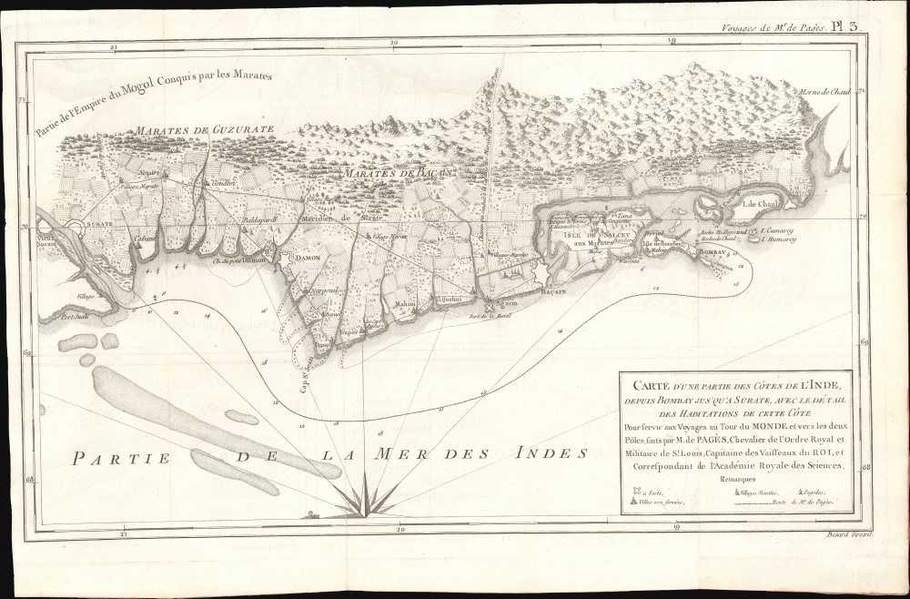
Carte d'Une Partie des Côtes de L'Inde, depuis Bombay jus'qu'a Surate, avec le détail des Habitations de cette Côte.
sold
- Digital Map Information
- Suitable for large format printing
- File Size: 8.12 MB
- File Type: ZIP / TIFF
- ICC color profile embedded
- Delivered instantly via download link
This is an unusual 1782 Pierre-Marie-François Pàges map of Bombay, India, and its vicinity. The map is uncommon in that it details not just the British fortification on Bombay Island, but also the surrounding Gujarat countryside and communities. (more details)
Birthplace of Surfing.

A French Prince in the American Civil War.

Pamlico Sound (Caroline du Nord).
sold
- Digital Map Information
- Suitable for large format printing
- File Size: 9.12 MB
- File Type: ZIP / TIFF
- ICC color profile embedded
- Delivered instantly via download link
This is a striking 1890 Dumas Vorzet map of the Pamlico Sound and Albemarle Sound, eastern North Carolina, issued to illustrate the scarce atlas volume of the French edition of the Prince Philippe d'Orléans' Histoire de la Guerre Civile en Amérique. (more details)
Ephemeral Confederate Arizona!

Map of the United States and Territories. Together with Canada etc.
sold
- Digital Map Information
- Suitable for large format printing
- File Size: 21.68 MB
- File Type: ZIP / TIFF
- ICC color profile embedded
- Delivered instantly via download link
This is an 1862 Samuel Augustus Mitchell, Jr. map of the United States during the second year of the American Civil War (1861 - 1865). Notably, this map illustrates the ephemeral Confederate Arizona Territory and is one of the first maps to include the newly formed Colorado Territory and Dakota Territory. This map captures one of the most volatile years in American history. (more details)
Texas during the Civil War.

County Map of Texas.
sold
- Digital Map Information
- Suitable for large format printing
- File Size: 9.75 MB
- File Type: ZIP / TIFF
- ICC color profile embedded
- Delivered instantly via download link
This is S. A. Mitchell Junior's 1862 map of Texas and part of New Mexico - issued at the height of the American Civil War (1861 - 1865). This is one of the more attractive atlas maps of Texas to appear in the mid-19th century. (more details)
Colorful 19th century map of New York City.

Plan of New York etc.
sold
- Digital Map Information
- Suitable for large format printing
- File Size: 186.77 MB
- File Type: ZIP / TIFF
- ICC color profile embedded
- Delivered instantly via download link
A beautiful example of S. A. Mitchell's 1862 map of New York City - one of the more colorful and attractive atlas maps of New York to appear in the mid-19th century. (more details)
California during the Civil War.

County Map of California.
sold
- Digital Map Information
- Suitable for large format printing
- File Size: 9.68 MB
- File Type: ZIP / TIFF
- ICC color profile embedded
- Delivered instantly via download link
A scarce 1862 S. A. Mitchell map of California with a large inset of Great Salt Lake, Utah, showing the Mormon settlements. (more details)
New Orleans during the Civil War.
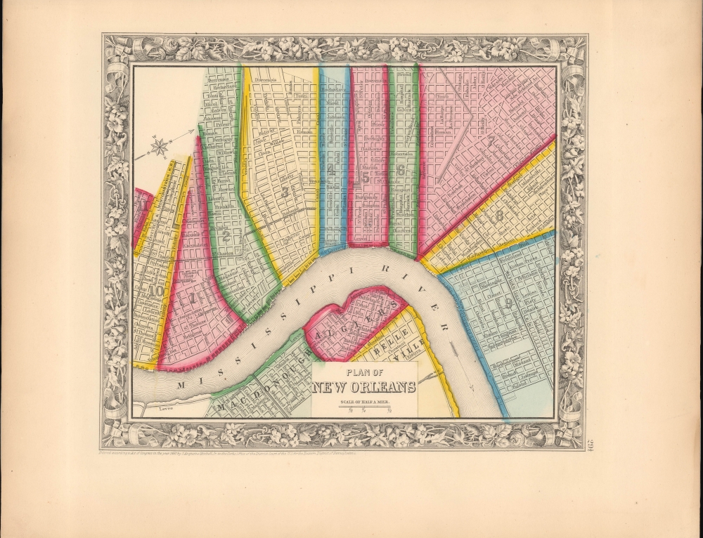
Plan of New Orleans.
sold
- Digital Map Information
- Suitable for large format printing
- File Size: 7.9 MB
- File Type: ZIP / TIFF
- ICC color profile embedded
- Delivered instantly via download link
This is an 1862 Samuel Augustus Mitchell, Jr. city American Civil War era map of New Orleans, Louisiana. (more details)
Remarkable example, exhibiting Catholic censorship.
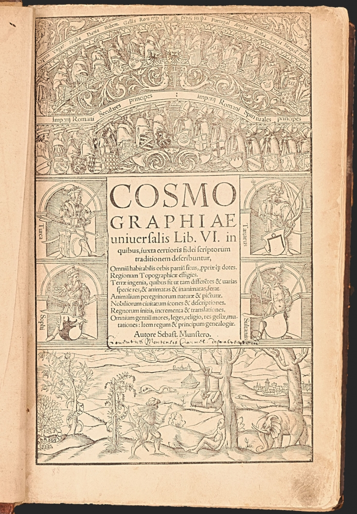
Cosmographiae universalis Lib. VI.
sold
A superb, fascinating example of Sebastian Münster's masterpiece: his Cosmographia, in its much-expanded, first, Latin edition of 1550. Münster's work had between 1544 and 1548 been only published in German. With this edition, opening the work to an international audience, Münster added a wealth of larger and more elaborate images that would seal its popularity. This compendium would for more than half a century provide the European literate layperson their best source of information about the world, via its lively descriptions, engaging woodcut illustrations, and its array of maps. It was also one of the most copiously illustrated, early books, containing nearly 1000 woodcuts as well as the first separate maps of America and Asia, and the first detailed contemporaneous maps of Europe and Africa. Its regional maps present their respective areas in what were often the earliest modern depictions available to the reader.
That the book retained an audience long after its publication is attested to by the present example: almost two hundred and fifty years after its publication, it fell under the scrutiny of a Catholic censor, expurgating passages deemed harmful to the Church, the Papacy, and the modesty of the presumably Catholic reader. (more details)
That the book retained an audience long after its publication is attested to by the present example: almost two hundred and fifty years after its publication, it fell under the scrutiny of a Catholic censor, expurgating passages deemed harmful to the Church, the Papacy, and the modesty of the presumably Catholic reader. (more details)
Classic Dutch World, updated French Cartography.
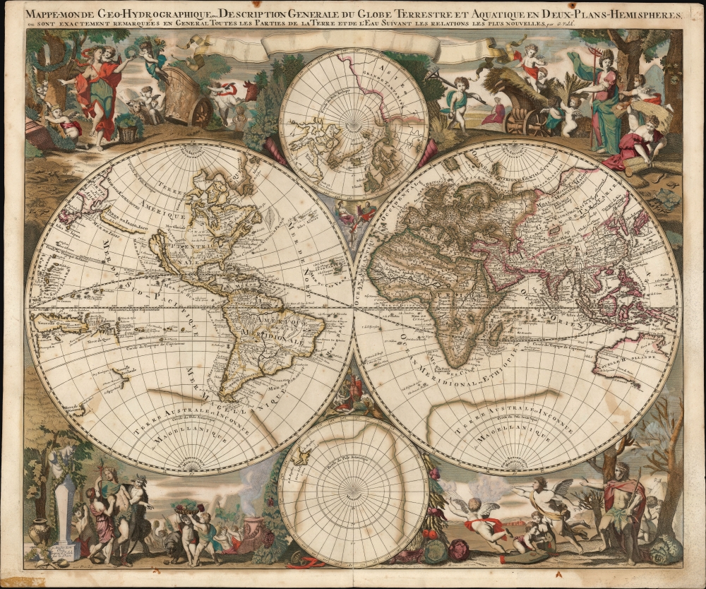
Mappe-Monde Geo-Hydrographique, ou Description Generale Du Globe Terrestre et Aquatique En Deux-Plans-Hemispheres
$6,500.00
Acquire
- Digital Map Information
- Suitable for large format printing
- File Size: 28.15 MB
- File Type: ZIP / TIFF
- ICC color profile embedded
- Delivered instantly via download link
This is a striking, original color example of Gerard Valk's classic 1686 double hemisphere map of the world. The map combines the aesthetics of the Dutch Golden Age with the superior French cartography of Nicolas Sanson. (more details)
Spectacularly presented.

L'Asie divisée en ses Empires et Royaumes.
$3,500.00
Acquire
- Digital Map Information
- Suitable for large format printing
- Full resolution TIFF file
- ICC color profile embedded
- Delivered instantly via download link
A spectacularly presented c. 1787 Charles-François Delamarche / Robert de Vaugondy map of Asia. The beautifully presented map is laid down on unusual patterned linen and set into a fine royal blue slipcase with gold gilt tooling. (more details)
First plate of the elder Merian's self-referential panorama of Paris.

Parys.
sold
- Digital Map Information
- Suitable for large format printing
- File Size: 30.67 MB
- File Type: ZIP / TIFF
- ICC color profile embedded
- Delivered instantly via download link
This is a superb example of Matthaus Merian's view of Paris, France - arguably the most desirable of Merian's panoramas in that it is also a self-portrait. (more details)
'One of the grandest, most strikingly wonderful and beautiful freaks of nature of its kind in the known world' - Bailey

Bird's Eye View of Watkins, N.Y.
sold
- Digital Map Information
- Suitable for large format printing
- File Size: 54.86 MB
- File Type: ZIP / TIFF
- ICC color profile embedded
- Delivered instantly via download link
This is a striking Sarah F. Bailey chromolithograph bird's-eye view map of Watkins Glen, located at the southern tip of Seneca Lake, of New York's stunning Finger Lakes. This view is notable as being the only 19th-century American bird's-eye view we are aware of to be drafted by a woman, Sarah Bailey, wife of prominent viewmaker O. H. Bailey. When this view was made, Watkins Glen, which refers more specifically to the stunning river gorges just west of Watkins, was widely promoted as a natural wonder. (more details)
Earliest specific map of Brazil.

[Brasil].
sold
- Digital Map Information
- Suitable for large format printing
- File Size: 12.38 MB
- File Type: ZIP / TIFF
- ICC color profile embedded
- Delivered instantly via download link
This Giovanni Battista Ramusio's scarce 1565 map of Brazil, the first printed map to focus specifically on the area. It first appeared in Ramusio's 1556 Navigationi et Viaggi, the first collection of explorers' first-hand accounts of their travels. The woodcut represents the first glimpse in print specifically of Brazil. The geographical information is generally credited to Giocomo Gastaldi (1500 - 1566). Much of that detail, and all of the socio-ethno-economic imagery of the map appears to have been drawn either from the 1519 manuscript Lopo Homem (1497 - 1572) Carta do Brasil, or from one or another manuscript of the Dieppe school. This is significant. An overwhelming percentage of maps of South America in the 16th century, printed and manuscript, carry either imagery or text describing the indigenous population as savages and cannibals. Of the early printed maps of Brazil, this is the only to highlight instead the harvesting of the lumber, which represented the initial economic draw for Europeans: Brazil wood, which when harvested and processed produced a highly desirable dye. Not only are the natives shown harvesting trees and hauling them to the shore - they are also shown with parrots and monkeys, also desirable trade items. More significantly, the map shows a native exchanging lumber for a cup, given by men in European garb. This is one of the only printed maps to depict the active trade which had been underway for decades between French mariners from Normandy and the Tupi peoples of Brazil. Ramusio, as Venetian ambassador to France, may well have had access to French manuscript maps of the Dieppe school (which Surekha Davies notes were remarkable for their depiction of Brazilian indigenes as trade partners rather than predators.) The ships shown sailing the Atlantic here tell a related story: The Portuguese enjoyed a Papally decreed monopoly on the exploitation and colonization of Brazil under the 1494 Treaty of Tordesillas. French / Norman trade with Brazilian natives was done in defiance of the Portuguese, frequently meeting armed resistance. Of the five ships on this map, the smaller three sport the arms of Portugal. The two larger ships in the foreground bear the French fleurs-de-lis. This is a common thread appearing on Ramusio's maps: the notion that whatever the Portuguese have found around the world, the French ought to be able to take. (more details)
De l'Isle's State-of-the-art cartography in a Dutch edition.
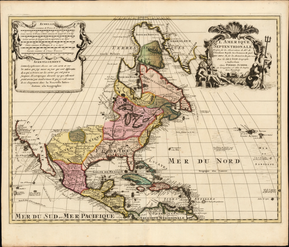
L' Amerique Septentrionale, Dressée sur les Observations de Mrs. de l'Academie Royale des Sciences, et quelques autres, et sur les Memoires les plus recens Par G. De l'Isle Geographe. a Amsterdam chez Pierre Schenk sur le vygendam, a l' Atlas de Sanson. Avec Privilege 1708.
$1,500.00
Acquire
- Digital Map Information
- Suitable for large format printing
- File Size: 22.52 MB
- File Type: ZIP / TIFF
- ICC color profile embedded
- Delivered instantly via download link
A truly beautiful original color example of Peter Schenk's 1708 edition of De L'Isle's foundational 1700 map of North America. Although derivative of De L'Isle, the map is richly decorative with a wealth of intriguing cartographic anomalies and tidbits. (more details)
Late Colonial Romantic View of French West Africa.

A.O.F. / [Afrique-Occidentale Française].
sold
- Digital Map Information
- Suitable for large format printing
- File Size: 47.36 MB
- File Type: ZIP / TIFF
- ICC color profile embedded
- Delivered instantly via download link
This vibrant c. 1950 pictorial map of French West Africa was drawn by artist Gabriel Carriat-Rolant, printed in Casablanca. Aside from its artistic quality, the map provides a fascinating glimpse into French views of their African empire, poised to rapidly collapse within a few years. (more details)