
Detailed map of Florida and Tortugas Island including early survey notations

Sketch F Showing the Progress of the Survey in Section VI. With a General Reconnaissance of the Coast of Florida 1848-57.
sold
- Digital Map Information
- Suitable for large format printing
- File Size: 4.95 MB
- File Type: ZIP / TIFF
- ICC color profile embedded
- Delivered instantly via download link
This is a rare 1857 U.S. Coast Survey chart of the Florida coast. Omits the southern tip of Florida. An inset in the lower left quadrant details Tortugas Island. There is an interesting swath of inland detail between St. Mary's and the Cedar Keys – indicating a ... (more details)
Map detailing Galveston Bay in Texas.

(I No. 2) Preliminary Sketch of Galveston Bay.
sold
- Digital Map Information
- Suitable for large format printing
- DPI: 300
- File Size: 6.59 MB
- File Type: ZIP / TIFF
- ICC color profile embedded
- Delivered instantly via download link
An uncommon 1851 U.S. Coast Survey nautical chart or maritime map of Galveston Bay, Texas. The map covers from Turtle Bay to the entrance to Galveston Bay, including the City of Galveston, Galveston Island, and Bolivar Peninsula. Supplementary inset maps in the ... (more details)
Beautiful bird's eye-view of Acapulco Mexico.

Acapulco.
sold
- Digital Map Information
- Suitable for large format printing
- DPI: 300
- File Size: 5.09 MB
- File Type: ZIP / TIFF
- ICC color profile embedded
- Delivered instantly via download link
This is a beautiful c. 1757 map of Acapulco de Juarez, commonly known as Acapulco, Mexico by Jan van Schley. Features the Acapulco Bay and its fortified port in incredible detail. Important buildings, forests and mountains are depicted in profile, give a ... (more details)
Beautiful nautical chart detailing the coastline of California and Oregon.

Sketch J No. 13 Reconnaissance of the Western Coast of the United States from Monterey to the Columbia River in three sheets Sheet No. 2.
sold
- Digital Map Information
- Suitable for large format printing
- DPI: 300
- File Size: 6.38 MB
- File Type: ZIP / TIFF
- ICC color profile embedded
- Delivered instantly via download link
This is an attractive 1851 U.S. Coast Survey chart of the California and Oregon Coast. It covers from Cape Mendocino north to Umpqua Head and includes Trinidad City and Eureka. This map is the second sheet of three, which together chart the entire ... (more details)
Attractive map of the Western Cost of the United States with nautical markings down the coast.

Sketch J No. 14 Reconnoissance of the Western Cost of the United States From Monterey to the Columbia River in three sheets. Sheet No. 3
sold
- Digital Map Information
- Suitable for large format printing
- DPI: 300
- File Size: 5.19 MB
- File Type: ZIP / TIFF
- ICC color profile embedded
- Delivered instantly via download link
This is an attractive 1851 U.S. Coast Survey chart of the Washington and Oregon Coast. It covers from Cape Arago in Oregon north to the Columbia River and includes Astoria, Cape Lookout, Cape Foulweather and Cape Disappointment or Cape Hancock. ... (more details)
Nautical chart of the Mississippi River Delta.

Sketch H. Showing the progress of the Survey in Section No. 8 1846 - 1851.
sold
- Digital Map Information
- Suitable for large format printing
- DPI: 300
- File Size: 8.65 MB
- File Type: ZIP / TIFF
- ICC color profile embedded
- Delivered instantly via download link
An attractive hand colored 1853 U.S. Coast Survey triangulation chart or map of the Mississippi Delta. Depicts the Mississippi Delta and the Gulf Coast from Lake Pontchartrain, Louisiana eastward past New Orleans, as far as Mobile Bay, ... (more details)
Map depicting the Coast Survey's early mappings of the Puget Sound.

Sketch K Showing the Progress of the Survey in Section No. XI (Upper Sheet) From Tillamook Bay to the Boundary from 1851 to 1861.
sold
- Digital Map Information
- Suitable for large format printing
- File Size: 8.33 MB
- File Type: ZIP / TIFF
- ICC color profile embedded
- Delivered instantly via download link
This is an uncommon hand-colored 1861 U.S. Coast Survey map and triangulation chart of Washington, Vancouver and the Puget Sound from Tillamook Head to Vancouver Island, including Juan De Fuca Strait, the Puget Sound, Olympia, and ... (more details)
Triangulation chart of Florida's northwest coast.

Sketch G Showing the Progress of the Survey in Part of Section VII From 1849 to 1855.
sold
- Digital Map Information
- Suitable for large format printing
- File Size: 4.11 MB
- File Type: ZIP / TIFF
- ICC color profile embedded
- Delivered instantly via download link
This is a very attractive example of the 1855 U.S. Coast Survey nautical progress chart or map of the Gulf Coast of northern Florida. Centered on St. Andrew's Sound, this map extends from Perdido Bay eastwards past Pensacola Bay ... (more details)
The Sea of the West at its highest expression.
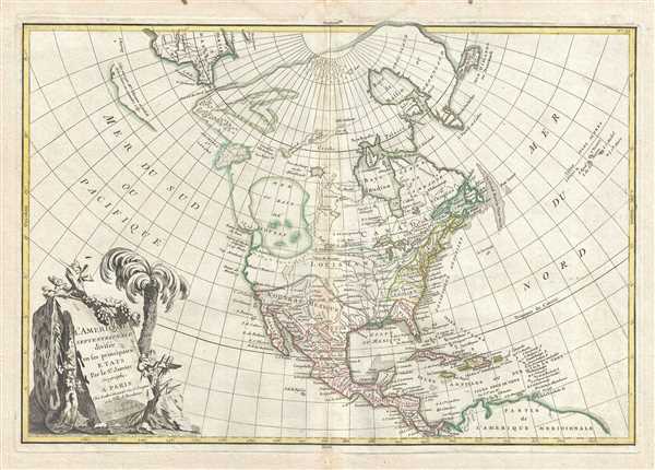
L'Amerique Septentrionale Divisee en ses Principaux Etats.
sold
- Digital Map Information
- Suitable for large format printing
- DPI: 300
- File Size: 8.62 MB
- File Type: ZIP / TIFF
- ICC color profile embedded
- Delivered instantly via download link
An altogether fascinating first edition example of Jean Janvier 1762 map of North America, including one of the most ambitions depictions of the Sea of the West in any map. The map covers the continent from Panama to the Arctic Circle, extends westward to include parts of Asia and eastward as far as Iceland. This map, which is heavily influenced by the theoretical mappings of Guillaume de l'Isle and Philippe Buache, went through several states of which this is the first and possibly the most interesting. Javier divides the continent according to the three colonial powers that controlled it, with England controlling the colonies along the east coast, France occupying Canada and Louisiana, and Spain dominating Mexico, Florida, Cuba and Central America. (more details)
Map showing British holdings in America at the time of the American Revolutionary War.

Canada IIe. Feuille.
sold
- Digital Map Information
- Suitable for large format printing
- DPI: 300
- File Size: 8.28 MB
- File Type: ZIP / TIFF
- ICC color profile embedded
- Delivered instantly via download link
Printed in c.1778, in the midst of the American Revolutionary War, this is Bonne's important map of Louisiana and the British claims in North America. Covers from the Grand Banks south to Florida and westward as far as Mexico and ... (more details)
Map of the Holy Land noting the lands claimed by the Tribes of Israel.
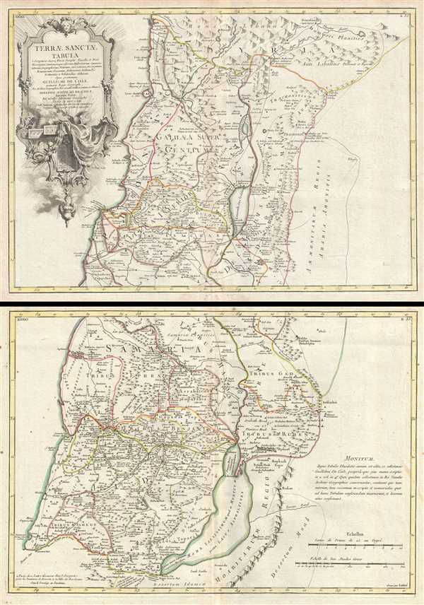
Terrae Sanctae Tabula e Scripturae Sacrae, Flavii Josephi, Eusebii et Divi Heironymi …
sold
- Digital Map Information
- Suitable for large format printing
- DPI: 300
- File Size: 20.1 MB
- File Type: ZIP / TIFF
- ICC color profile embedded
- Delivered instantly via download link
A beautiful example of Guillaume and Joseph Delisle's 1763 decorative map of the Holy Land, including Israel and Palestine. In two sheets, the map covers the region from Gaza and the Dead Sea north to Sidon (modern Lebanon) and ... (more details)
Beautiful early map of West Indies with a primitive Florida.

Carte geo-hydrographique du Golfe du Mexique et de ses isles. Construit d'apres les memoires les plus recens, et assujeties, pour l'emplacement de ces principales positions aux latitudes et longitudes, determinees par observation.
sold
- Digital Map Information
- Suitable for large format printing
- DPI: 300
- File Size: 9.61 MB
- File Type: ZIP / TIFF
- ICC color profile embedded
- Delivered instantly via download link
A beautiful example of Zannoni's c.1778 map of the West Indies, Florida and Central America. Covers from the Gulf of Mexico to the lesser Antilles including all of the West Indies, Florida and Central America, with parts of ... (more details)
A decorative 18th century map of the West Indies with detailed description in French.

Guayane, Terre Ferme, Isles Antilles, et Nlle. Espagne.
sold
- Digital Map Information
- Suitable for large format printing
- DPI: 300
- File Size: 13.24 MB
- File Type: ZIP / TIFF
- ICC color profile embedded
- Delivered instantly via download link
A stunning decorative 1786 map of Mexico, Central America and the West Indies by Louis Brion de la Tour. It covers from the Chesapeake Bay south to Peru and the Amazon but focuses on Mexico and the Caribbean region. The map ... (more details)
Includes the Muller Peninsula in Alaska and the Sea of the West in North America.
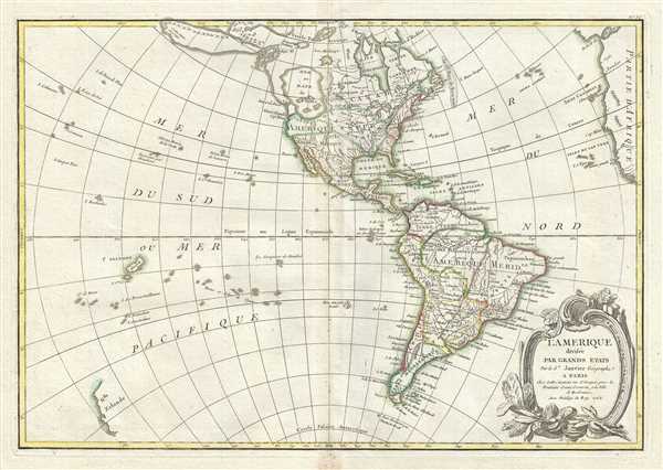
l'Amerique divisee Par Grans Etats.
sold
- Digital Map Information
- Suitable for large format printing
- DPI: 300
- File Size: 7.95 MB
- File Type: ZIP / TIFF
- ICC color profile embedded
- Delivered instantly via download link
This is an altogether fascinating map of North America and South America by Jean Janvier dating to 1762. It covers both continents from the Antarctic Circle to the Arctic Circle, extends westward to New Zealand and eastward ... (more details)
Representation of the Spanish holdings in North America.
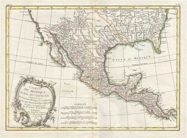
Carte du Mexique ou de la Nlle. Espagne Contenant aussi le Nouveau Mexique, la Californie, avec une Partie des Pays adjacents.
sold
- Digital Map Information
- Suitable for large format printing
- DPI: 300
- File Size: 7.77 MB
- File Type: ZIP / TIFF
- ICC color profile embedded
- Delivered instantly via download link
A beautiful example of Rigobert Bonne's 1771 map of Mexico and Florida. Covers from Baja California eastward to Florida and Carolina, extend northwards as far as the mouth of the Chesapeake Bay and southwards to Panama. ... (more details)
An uncommon map of eastern Africa showing the legndary gold mines.

Partie de la Cote Orientale D'Afrique avec L'Isle de Madagascar et les Cartes particulieres des Isles de France et de Bourbon.
sold
- Digital Map Information
- Suitable for large format printing
- DPI: 300
- File Size: 7.13 MB
- File Type: ZIP / TIFF
- ICC color profile embedded
- Delivered instantly via download link
A beautiful example of Rigobert Bonne's c.1778 decorative map of southeastern Africa and Madagasgar. Roughly covers the territory current incorporated into Mozambique and Madagascar. Also includes inset map of the Isle ... (more details)
An early, speculative mapping of the western hemisphere.
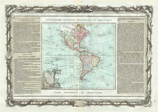
L'Amerique dressee pour l'etude de la Geographie.
sold
- Digital Map Information
- Suitable for large format printing
- DPI: 300
- File Size: 13.32 MB
- File Type: ZIP / TIFF
- ICC color profile embedded
- Delivered instantly via download link
A hard to find 1786 map of the North America and South America by French cartographer Louis Brion de la Tour. Depicts the whole of North and South America with several interesting cartographic features. The American ... (more details)
Speculative map of the mythical Lake Xarayes.

l'Amerique Meridionale divisee en ses principaux Etats.
sold
- Digital Map Information
- Suitable for large format printing
- DPI: 300
- File Size: 7.35 MB
- File Type: ZIP / TIFF
- ICC color profile embedded
- Delivered instantly via download link
This is a beautiful example of Jan Janvier's 1762 decorative map of South America. It covers from the island of Hispaniola and the Yucatan south to Tierra del Fuego and Cape Horn, east to Africa, and west to Mexico. ... (more details)
Speculative map of the mythical Lake Xarayes.
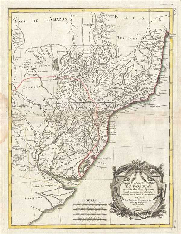
Carte du Paraguay et partie des Pays adjacants.
sold
- Digital Map Information
- Suitable for large format printing
- DPI: 300
- File Size: 9.09 MB
- File Type: ZIP / TIFF
- ICC color profile embedded
- Delivered instantly via download link
A beautiful example of Rigobert Bonne's 1771 decorative map of Paraguay. Covers from the Rio de la Plata north well into Brazil and the Amazon, extends westward as far as Cordova, and eastward to San Salvador, ... (more details)
Bonne's mapping of northern South America with the apocryphal Lake Parima.

Carte de La Terre Ferme, de la Guyane et du Pays des Amazones.
sold
- Digital Map Information
- Suitable for large format printing
- DPI: 300
- File Size: 7.48 MB
- File Type: ZIP / TIFF
- ICC color profile embedded
- Delivered instantly via download link
A beautiful 1771 example of Rigobert Bonne's decorative map of northern South America. Covers from Honduras and the Windward Isles south as far as 12 degrees south latitude. This region, known since the days ... (more details)