

Panoramic Map of the Baltimore and Philadelphia (Ericsson Line) Steamboat Companys Route.
sold
- Digital Map Information
- Suitable for large format printing
- Full resolution TIFF file
- ICC color profile embedded
- Delivered instantly via download link
This is a charming 1897 pictorial map of the Baltimore Philadelphia Steamship Company Route or the Ericsson Line by Avil Print and Co., Philadelphia. It covers the entire route from Baltimore through the Chesapeake Bay, the Chesapeake and Delaware Canal and the ... (more details)
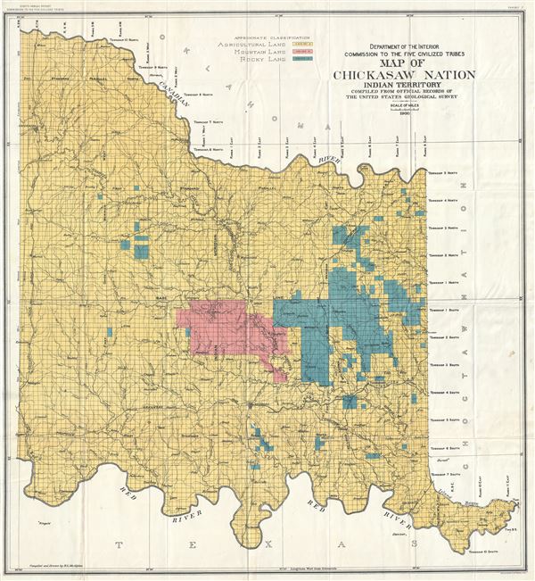
Department of Interior Commission to the Five Civilized Tribes Map of Chickasaw Nation Indian Territory Compiled from Official Records of The United States Geological Survey.
sold
- Digital Map Information
- Suitable for large format printing
- Full resolution TIFF file
- ICC color profile embedded
- Delivered instantly via download link
This is a scarce and beautiful 1900 R. L. McAlpine map of the Chickasaw Nation issued by the Department of Interior Commission of the Five Civilized Tribes and compiled from the official records of the United States Geological Survey. Part of modern day ... (more details)

Rhode Island and Providence Plantations A Pictorial Map Showing Historical and Present Day Points of Interest.
sold
- Digital Map Information
- Suitable for large format printing
- Full resolution TIFF file
- ICC color profile embedded
- Delivered instantly via download link
This is a beautiful 1936 pictorial map of Rhode Island including the Narragansett Bay by Phillips D. Booth. It covers 'The Ocean State,' officially the State of Rhode Island and Providence Plantations, including Narragansett Bay, Block Island, Conanicut ... (more details)
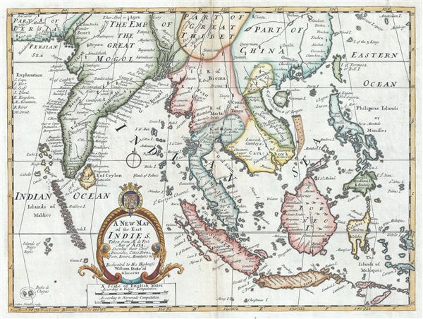
A New Map of the East Indies, Taken from Mr. de Fer's Map of Asia, Shewing their Chief Divisions, Cities, Towns, Ports, Rivers, Mountains etc.
sold
- Digital Map Information
- Suitable for large format printing
- Full resolution TIFF file
- ICC color profile embedded
- Delivered instantly via download link
This is an attractive and scarce 1712 map of India and the East Indies by Edward Wells of Oxford. Centered on Malaysia, this beautiful map covers all of Southeast Asia from Persia to the Timor Island, inclusive of the modern day nations of India, ... (more details)
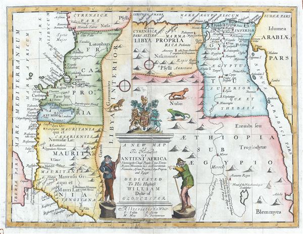
A New Map of The North Part of Antient Africa Shewing the Chiefe People, Cities, Towns, Rivers, Mountains, etc. in Mauritania, Numidia, Africa Propia, Libya Propia, and Egypt.
sold
- Digital Map Information
- Suitable for large format printing
- Full resolution TIFF file
- ICC color profile embedded
- Delivered instantly via download link
This is an uncommon and beautiful 1712 map of the northern part of Africa in ancient times by Edward Wells of Oxford. This interesting map depicts the northern coastlines of Africa with an unusual orientation, with the eastern part of the ... (more details)
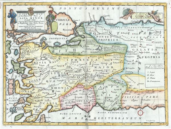
A New Map of the Western Parts of Asia Minor Largely Taken: Shewing their Antient Divisions, Countries or People, Chiefe Cities, Towns, Rivers, Mountains etc.
sold
- Digital Map Information
- Suitable for large format printing
- Full resolution TIFF file
- ICC color profile embedded
- Delivered instantly via download link
This is a beautiful 1712 map of the western part of Asia Minor or Turkey by Edward Wells of Oxford. It covers the western part of Turkey from the Aegean Sea east as far as central Turkey, noting several towns, cities, rivers, mountains, ... (more details)
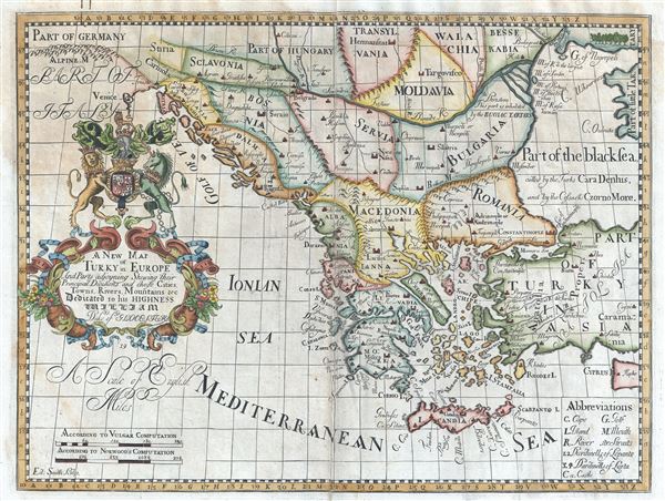
A New Map of Turky in Europe And Parts adjoyning Shewing their Principal Divisions and chiefe Cities, Towns, Rivers, Mountains etc. Dedicated to his Highness William Duke of Glocester.
sold
- Digital Map Information
- Suitable for large format printing
- Full resolution TIFF file
- ICC color profile embedded
- Delivered instantly via download link
This is an attractive 1712 map of Greece, the Balkans, Macedonia and Turkey in Europe by Edward Wells of Oxford. Centered on modern day Greece, it covers from Transylvania and Hungary to Crete and the Mediterranean and from Venice east ... (more details)
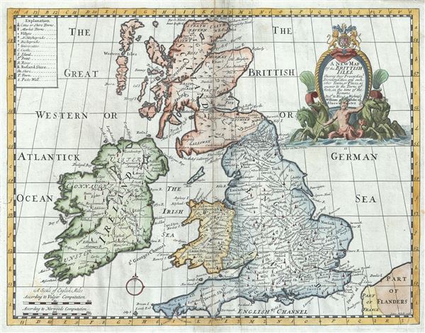
A New Map of the Brittish Isles Shewing their Present Genl. Divisions, Cities and such other Towns, or Places, as answer to the Towns of note, in the time of the Romans.
sold
- Digital Map Information
- Suitable for large format printing
- Full resolution TIFF file
- ICC color profile embedded
- Delivered instantly via download link
This is a beautiful 1712 map of the British Isles by Edward Wells of Oxford. It covers all of England, Wales, Scotland and Ireland. Highly detailed, it notes the present (1712) general division, cities, towns and places as answer to ... (more details)
The finest map of London issued in 1823.

Pigot and Co's New Plan of London, Taken from the best Authorities with the Geographical bearings from the Dome of St. Paul's And formed into Divisions by means of circular lines each division being referred to in their list of Streets and Public Buildings in the Metropolis, The whole forming the most complete guide to London and ITS VICINITY YET PUBLISHED.
sold
- Digital Map Information
- Suitable for large format printing
- DPI: 300
- File Size: 28.68 MB
- File Type: ZIP / TIFF
- ICC color profile embedded
- Delivered instantly via download link
An attractive 1823 first edition example of James Pigot's map of London, England. Centered on the Thames River, Pigot's map covers from Islington to the East India Dock and from Camberwell to Kensington Gardens. The City of London ... (more details)
Impressive original color with fine gilt work.

Regnum Hiberniae divisum in Quatuor Partes quae sunt Ultonia Conachia Lagenia et Momonia quae et sunt Divisae in Omnes Suos Comitatus.
sold
- Digital Map Information
- Suitable for large format printing
- Full resolution TIFF file
- ICC color profile embedded
- Delivered instantly via download link
This is a rare large format map of Ireland by Frederik de Witt. Issued in 1680, the map covers the entirety of insular Ireland in considerable detail. Counties, roadways, rivers, swamps, forests, and mountain rangers are noted. ... (more details)

Plan de la Ville de Boston et ses Environs.
sold
- Digital Map Information
- Suitable for large format printing
- Full resolution TIFF file
- ICC color profile embedded
- Delivered instantly via download link
This hand colored map is a c. 1756 map of Boston, Massachusetts. Attributed to French cartographer Jacques-Nicholas Bellin, this map was issued for the French edition of Provost's Histoire des VoyagesÂ… . Beautifully rendered ... (more details)

Cape Poge and adjacent Shoals.
sold
This is a scarce and beautiful 1842 nautical chart or maritime map of Cape Poge, Martha's Vineyard, Massachusetts. It covers the region including parts of Cape Cod, Martha's Vineyard Island, Chappaquidick Island and Muskeget ... (more details)
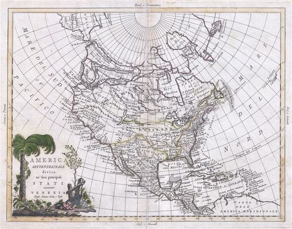
America Settentrionale divisa ne'suoi principali Stati.
sold
- Digital Map Information
- Suitable for large format printing
- Full resolution TIFF file
- ICC color profile embedded
- Delivered instantly via download link
This is an exceptionally stunning example of Antonio Zatta's 1785 map of North America. It covers the North American continent from the Pacific Ocean to the Azores Islands north well into the Arctic and southwards as far as ... (more details)

France divided into Departments, etc. agreeable to the Decrees of the National Assembly.
sold
- Digital Map Information
- Suitable for large format printing
- Full resolution TIFF file
- ICC color profile embedded
- Delivered instantly via download link
This is Robert Wilkinson's finely detailed first edition 1794 map of France divided into departments. Corsica appears on an inset. The French Department system was established on March 4th, 1790 by the National ... (more details)

Islands in the Atlantic.
sold
- Digital Map Information
- Suitable for large format printing
- DPI: 300
- File Size: 5.54 MB
- File Type: ZIP / TIFF
- ICC color profile embedded
- Delivered instantly via download link
This is a fine example of the 1836 Society for the Diffusion of Useful Knowledge or S.D.U.K. map of the Islands of Atlantic Ocean. Essentially sixteen inset maps on one sheet, the map covers the Azores or Western ... (more details)
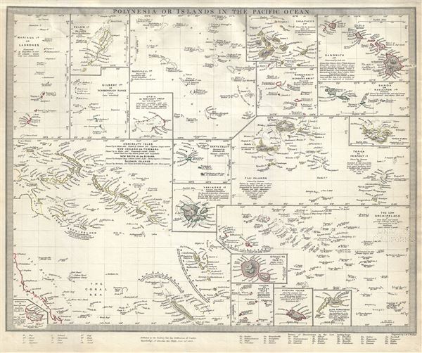
Polynesia or Islands in the Pacific Ocean.
sold
- Digital Map Information
- Suitable for large format printing
- DPI: 300
- File Size: 5.84 MB
- File Type: ZIP / TIFF
- ICC color profile embedded
- Delivered instantly via download link
This is a fine example of the 1840 Society for the Diffusion of Useful Knowledge or S.D.U.K. map of the islands of the Pacific Ocean or Polynesia. Essentially twenty maps on one sheet, it covers the Mariana ... (more details)

The Pacific Ocean.
sold
- Digital Map Information
- Suitable for large format printing
- DPI: 300
- File Size: 4.43 MB
- File Type: ZIP / TIFF
- ICC color profile embedded
- Delivered instantly via download link
This is a fine example of the 1840 Society for the Diffusion of Useful Knowledge or S.D.U.K. map of the Pacific Ocean. Centered on the Sandwich or Hawaiian Islands, it depicts the entirety of the Pacific ... (more details)

Egypt.
sold
- Digital Map Information
- Suitable for large format printing
- DPI: 300
- File Size: 5.41 MB
- File Type: ZIP / TIFF
- ICC color profile embedded
- Delivered instantly via download link
This is a beautiful example of an 1831 Society for the Diffusion of Useful Knowledge or S.D.U.K. map of Egypt. It depicts Egypt, centered on the Nile River from its delta on the Mediterranean south as ... (more details)

West Africa I.
sold
- Digital Map Information
- Suitable for large format printing
- DPI: 300
- File Size: 5.71 MB
- File Type: ZIP / TIFF
- ICC color profile embedded
- Delivered instantly via download link
This is an uncommon and fascinating 1839 Society for the Diffusion of Useful Knowledge or S.D.U.K. map of western Africa. It covers from Mauritania south to the Gulf of Guinea and inland as far as ... (more details)

West Africa II.
sold
- Digital Map Information
- Suitable for large format printing
- DPI: 300
- File Size: 4.92 MB
- File Type: ZIP / TIFF
- ICC color profile embedded
- Delivered instantly via download link
This is an uncommon and fascinating 1839 Society for the Diffusion of Useful Knowledge or S.D.U.K. map of western Africa. It covers from modern day Ghana east as far as Lake Chad, including the ... (more details)