
Die Ära der Amerikanischen Revolution.

Special Karte von den Mitteleren Brittishen Colonien in Nord Amerika.
sold
- Digital Map Information
- Suitable for large format printing
- File Size: 9.26 MB
- File Type: ZIP / TIFF
- ICC color profile embedded
- Delivered instantly via download link
This is Thomas Albrecht Pingeling's finely engraved map of the British American colonies, published soon after their declaration of independence in Christian Leiste's 1778 book Beschreibung des Brittischen Amerika. (more details)
Central Park as it was being built.

Map of the Central Park Showing the progress of the Work up to January 1st, 1865.
sold
- Digital Map Information
- Suitable for large format printing
- File Size: 12.8 MB
- File Type: ZIP / TIFF
- ICC color profile embedded
- Delivered instantly via download link
A striking 1865 map of New York City's Central Park - issued while the park was still under construction. The landmark construction of Central Parks marked the inauguration of a new era of planned public greenspaces. (more details)
Northern California's 'Second Gold Rush'.

Plat of the Surveys Made at the Chloride and Bailey Quartz Mines. In Canon Creek Mining District, Trinity County, Cal.
sold
- Digital Map Information
- Suitable for large format printing
- File Size: 14.94 MB
- File Type: ZIP / TIFF
- ICC color profile embedded
- Delivered instantly via download link
This is a 1901 manuscript plat map of mining claims along the Canyon (or Cañon) Creek in Trinity County, California, prepared by surveyors Henry L. Lowden and Thomas J. Montgomery. (more details)
Fearmongering Japanese Propaganda suggesting an American Surprise attack on Japan - 7 years before WWII!

太平洋攻防戰略圖 / [Sketch Map of Pacific Warfare].
sold
- Digital Map Information
- Suitable for large format printing
- Full resolution TIFF file
- ICC color profile embedded
- Delivered instantly via download link
An astonishing 1935 Kagaku no Nihon Japanese propaganda map of the Pacific demonizing the United States and predicting an American attack on Japan. The map was part of internal Japanese pre-war propaganda efforts intended to establish a clear line of threat and thus promote Imperial Japanese expansionist goals as essential to national security - particularly Hawaii, which is central to this piece and, as the map suggests, key to controlling the Pacific. The cartographer assiduously documents the relative strength of the various powers in the region and their overlapping spheres of influence, presaging the Pacific War that would come seven years later. (more details)
Best French mapping of North America.
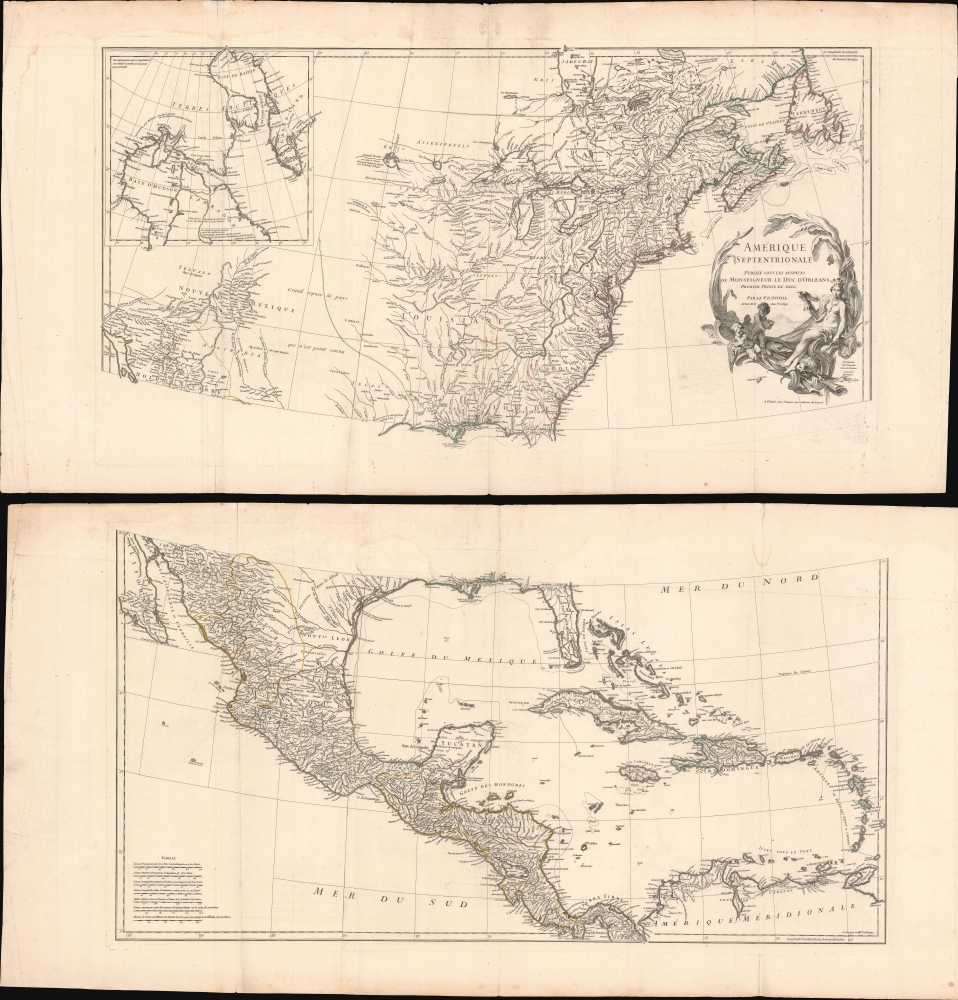
Amérique Septentrionale.
$1,800.00
Acquire
- Digital Map Information
- Suitable for large format printing
- Full resolution TIFF file
- ICC color profile embedded
- Delivered instantly via download link
This is the 1746 wall map of North America composed by Jean-Baptiste Bourguignon d'Anville, considered the finest French map of North America predating the French and Indian War (1754 - 1763). Nearly a century of French mapmaking and exploration in North America preceded this work, granting the map precedence, longevity, and a lasting influence. It was copied by Thomas Jefferys as the basis for his own 1755 map of North America. More than half a century later, it was among the maps consulted by Nicholas King for his seminal manuscript map of western North America compiled for the Lewis and Clark expedition. (more details)
Visualizing the Celestial Sphere.
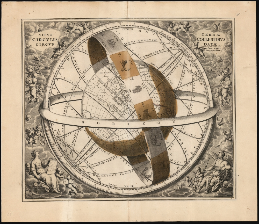
Situs Terrae Circulis Coelestibus Circundatae.
$1,800.00
Acquire
- Digital Map Information
- Suitable for large format printing
- DPI: 600
- File Size: 62.91 MB
- File Type: ZIP / TIFF
- ICC color profile embedded
- Delivered instantly via download link
This beautiful work is Andreas Cellarius' celestial chart, in its 1708 Valk and Schenk edition, illustrating the position of the Earth within the celestial sphere divided into its circles. Its lush, baroque presentation - filled with clouds, putti, and muses - frames a useful visual glossary illustrating terminology important both to the astronomer and to the geographer. (more details)
Japan's plan for the Pacific War, warned of in advance, revealed to the American public.

Amazing Invasion Map. Japs Plan to Seize West Coast.
sold
- Digital Map Information
- Suitable for large format printing
- Full resolution TIFF file
- ICC color profile embedded
- Delivered instantly via download link
This is a remarkable 1943 map of the Pacific Theater tied up with espionage and intrigue. The map was published in the Pittsburgh Sun-Telegraph, showing a prewar Japanese plan to attack Pearl Harbor and the West Coast of the United States. The map was stolen from a Japanese officer by a Korean attendant on an ocean liner in 1941, passed on to members of the U.S. Congress (where it was practically ignored), and finally published in the American press in August 1943 (well after the fact). (more details)
Twelve Tribes of Israel, with Exodus vignettes.

Judaea seu Palæstina ob Sacratissima Redemtoris vestigia hodie dicta Terra Sancta prout olim in duodecim tribus divisa, seperatis ab invicem Regnis Iuda et Israel expressis in super VI. ultimi temporis ejusdem Terræ Provinciis.
sold
- Digital Map Information
- Suitable for large format printing
- File Size: 24.11 MB
- File Type: ZIP / TIFF
- ICC color profile embedded
- Delivered instantly via download link
This is a beautiful example of J. B. Homann's 1707 map of the Holy Land. As Homann noted in the map's title, it is derived from the work of the French mapmaker Guillaume Sanson (1633 - 1703). (more details)
Follow the 32nd Armored Regiment across Europe during World War II.

Combat Trail of the 32nd Armored Regiment Third Armored Spearhead Division.
sold
- Digital Map Information
- Suitable for large format printing
- File Size: 18.96 MB
- File Type: ZIP / TIFF
- ICC color profile embedded
- Delivered instantly via download link
This is a 1945 World War II pictorial unit route map of the 32nd Armored Regiment in Europe. The map illustrates the Regiment's movements from its departure from England until it was taken off the line for the final time in late April 1944. (more details)
Communists and Capitalists during the Vietnam War.

Southeast Asia - A Small War Grows Up. Headline-Focus Wall Map 4.
sold
This is a 1965 Civil Education Service pictorial map of Southeast Asia highlighting regional social and political divisions during the Vietnam War. (more details)
Tea Drinking Dart Throwers!

813th T.D.'s Tea Drinking Dart Throwers!
sold
- Digital Map Information
- Suitable for large format printing
- File Size: 6.93 MB
- File Type: ZIP / TIFF
- ICC color profile embedded
- Delivered instantly via download link
This is a 1945 Robert Gluekstein pictorial map of the 813th Tank Destroyer Battalion in the United Kingdom during World War II. The map is a visual summary of the time the Battalion spent in the U.K. (more details)
The Big D.

Dallas A Texan Map Prepared by Old San Francisco Steak House.
sold
This is a 1986 Merle Ollom pictorial view of Dallas, Texas, drawn for the Old San Francisco Steak House. (more details)
Celebrate the folklore and legends of the United States.

Folklore and Legends of Our Country.
sold
This is a 1960 Frank J. Soltesz and Esso pictorial map of the United States celebrating national folklore and legends. Recognizable figures include Paul Bunyan and his Blue Ox, Long Jon Silver, Moby Dick, Jonny Appleseed, the heroes of the Alamo (including Davy Crockett), the Headless Horseman, and John Henry, among others. Insets in the lower left focus on the folklore and legends of Hawaii and Alaska - respectively. The verso includes explanatory text and a pictorial road map of the United States. (more details)
Scenic Wonderland on San Francisco Bay.

Thomas Bros. Map of San Rafael, San Anselmo, Ross, Kentfield, Fairfax, Larkspur and Corte Madera.
sold
- Digital Map Information
- Suitable for large format printing
- File Size: 31.36 MB
- File Type: ZIP / TIFF
- ICC color profile embedded
- Delivered instantly via download link
This is a c. 1946 Thomas Brothers folding map of San Rafael, San Anselmo, and nearby communities in Marin County, in the San Francisco Bay Area of California. (more details)
Egypt shortly after Napoleon's forces were driven out.

Egypt.
$175.00
Acquire
- Digital Map Information
- Suitable for large format printing
- File Size: 4.42 MB
- File Type: ZIP / TIFF
- ICC color profile embedded
- Delivered instantly via download link
This is a beautiful example of Anthony Finley's important 1827 map of Egypt. (more details)
Foundational Map of the Transmississippi.

Carte que les Gnacsitares ont Dessine sur / Carte de la Riviere Longue et de quelques Autres qui se Dechargent dans le Grand Fleuve Missisipi.
sold
- Digital Map Information
- Suitable for large format printing
- File Size: 14.91 MB
- File Type: ZIP / TIFF
- ICC color profile embedded
- Delivered instantly via download link
A foundational and influential map, this is the 1703 first edition of Baron Louis-Armand de Lom d'Arce de Lahontan's seminal map of the westernmost Great Lakes, the Mississippi River, and its enigmatic tributary river, the Riviere Longue or Long River, extending westwards towards the Rocky Mountains. Although Baron de Lahontan's cartography has been severely criticized and considered apocryphal by some, it exerted a profound influence on other mapmakers of the era, including Herman Moll, John Senex, Henry Popple, and Guillaume Delisle. (more details)
Exceptional School Map Case w/ Maps.

[Map Case w/ 8 Wall Maps.]
sold
This is an exceptional 1899 Rand McNally oak school room map case complete with its original 8 maps and key. Such cases were commercially manufactured for schools and government organizations from about 1900 to the 1940s. (more details)
Wartime German Military Reissue of Seminal French Map of Lebanon.
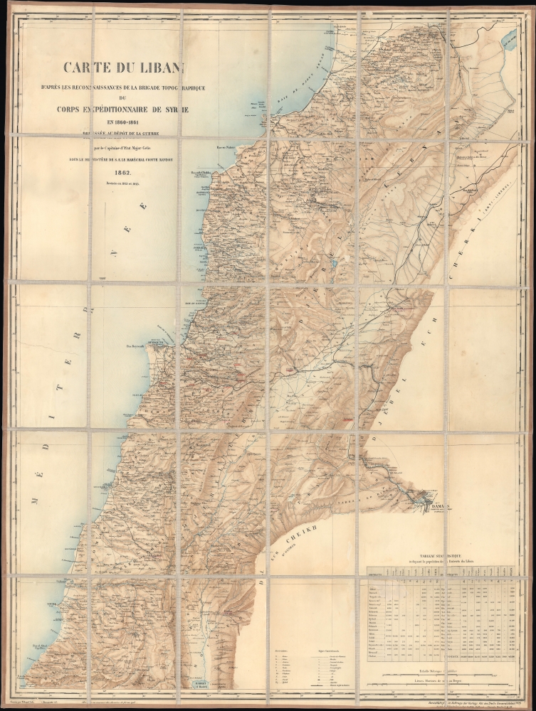
Carte du Liban d'aprés les reconaissances de la Brigade Topographique du Corps Expéditionnaire de Syrie en 1860-1861.
sold
- Digital Map Information
- Suitable for large format printing
- File Size: 54.45 MB
- File Type: ZIP / TIFF
- ICC color profile embedded
- Delivered instantly via download link
This is a 1915 WWI Era German Deputy General Staff issue of a French Dépôt de la Guerre map of Lebanon, then an Ottoman territory. It was issued in anticipation of combat action in the Lebanese Levant, an area then considered unstable due to weak Ottoman rule and ongoing sectarian violence. (more details)
First truly American flag - in RED!
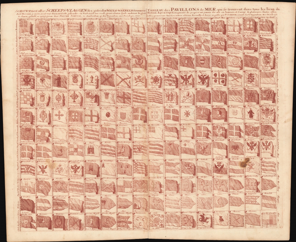
Schouw-park aller Scheeps-Vlaggen des geheelen Water-Waerelds... / Tableau des Pavillons de Mer, qui se trouvent dans tous les lieux du Monde Aquatique Augmente de 50 aui n ont jamais ete mis en lumiere... 1711.
$2,000.00
Acquire
- Digital Map Information
- Suitable for large format printing
- DPI: 600
- File Size: 72.75 MB
- File Type: ZIP / TIFF
- ICC color profile embedded
- Delivered instantly via download link
A vexillological wonder, this is the 1711 Pieter Schenk flag chart, here printed in unusual burgundy ink. In addition to its unusual color, this chart is significant for its inclusion of the ephemeral Globe Flag of New England (upper right corner). It also includes the flags of various trading companies, including the Dutch East India Company (VOC, Verenigde Oostindische Compagnie) and the Dutch West India Company (WIC, Geoctroyeerde Westindische Compagnie). (more details)
South America and its Treasures.

To the Right Honourable Charles Earl of Sunderland and Baron Spencer of Wormleighton... this Map of South America...
sold
- Digital Map Information
- Suitable for large format printing
- File Size: 52.5 MB
- File Type: ZIP / TIFF
- ICC color profile embedded
- Delivered instantly via download link
An attractive example of Hermann Moll's 1720 map of South America, here in a 1732 issue. The map was issued to counter the perceived dominance of the French maps of Guillaume De l'Isle's whose bold claims of French territory sparked outrage amongst the English, perhaps none more than Moll himself. (more details)