
Mysterious Middle-earth Map: An Unknown Cartographer Interprets Tolkien’s World
Massive Cartographic Analysis of Middle-earth
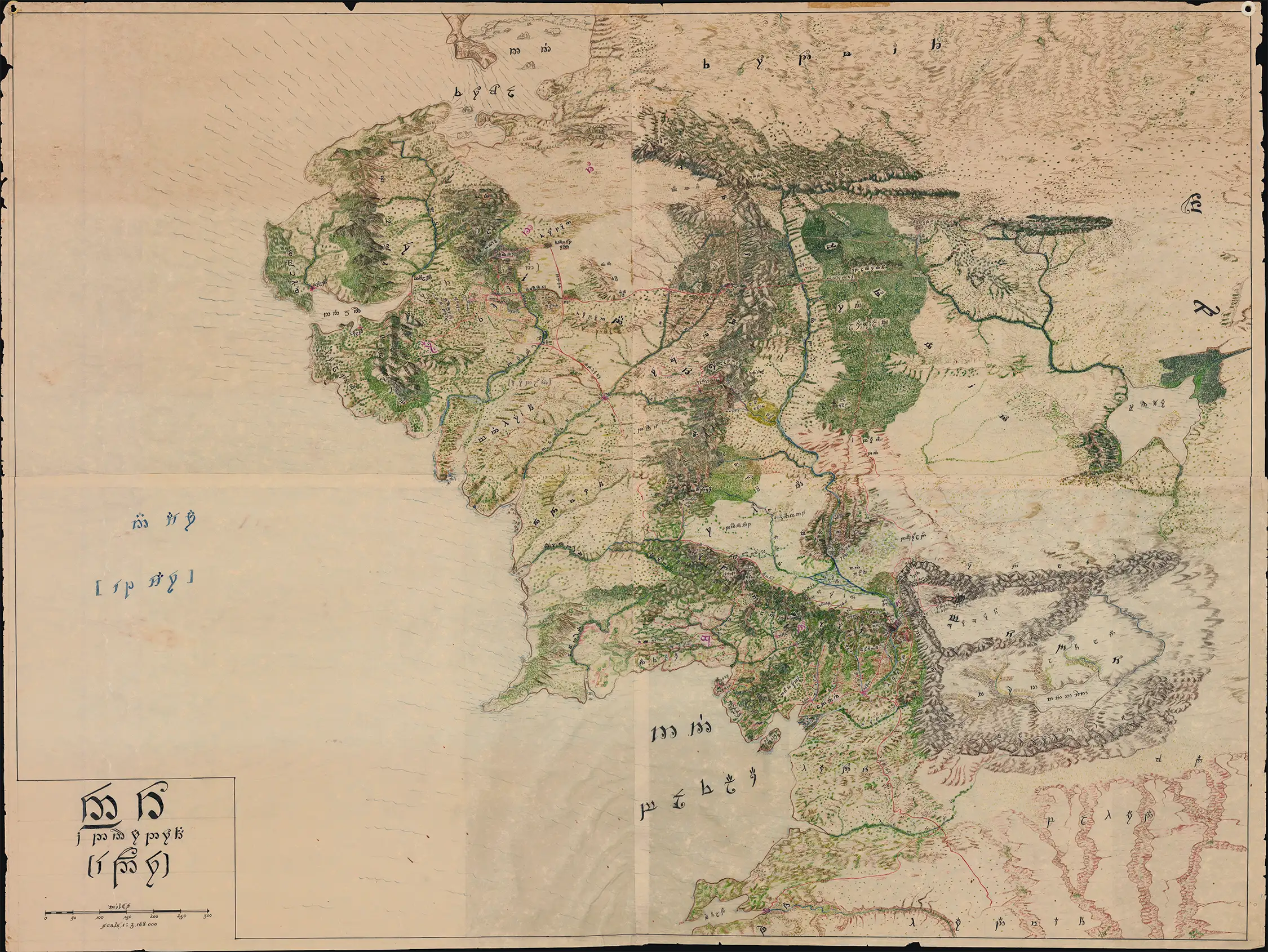
Mysterious Map of Middle-earth: How an Anonymous 1960s-70s cartographer applied the techniques of 18th-Century exploratory mapmaking - analyzing fragmentary accounts, reconciling clues, and applying geographical theories - to interpret Tolkien's world.
September 09, 2026

We were first offered this magnificent manuscript (hand drawn) map of Middle-earth in December 2025. Executed almost entirely in Tengwar, Tolkien's Elvish script, it was exactly the sort of object we dreamed of handling as lifelong Tolkien enthusiasts - though, of course, the seller could not have known that. We made an offer, but for reasons unknown, the map was sold to another dealer, and we assumed it had slipped from our grasp. Then, months later, quite by chance, we discovered it uncataloged among a colleague's backstock. We made our offer a second time. This time, it was accepted.
The map is remarkable not only for its monumental size, some 47 × 35.25 inches, but for the extraordinary depth of scholarship embodied in its construction. Neither its maker nor its precise date is known, but the paper and character of the work suggest a likely date in the 1970s. If so, it belongs to a very different era of Tolkien scholarship: before the Internet, before the proliferation of online fan communities and exhaustive digital resources, and before the publication of Unfinished Tales and Christopher Tolkien's monumental 12-volume History of Middle-earth. Depending on the precise date, the mapmaker may have had access to The Silmarillion, published in 1977, but little of the vast body of posthumously published material available to Tolkien scholars today.
Working with comparatively limited resources, the anonymous cartographer nevertheless undertook a staggering intellectual project. They mastered Tengwar well enough to employ it throughout the map and developed a working understanding of Sindarin and Quenya, the two most fully realized of Tolkien's Elvish languages. They then set about identifying and rendering the place names of The Hobbit and The Lord of the Rings, not merely those appearing on Tolkien's published maps, but obscure locations mentioned, described, or only indirectly alluded to in the texts.
More remarkably, the cartographer attempted to reconstruct geography that Tolkien never explicitly mapped. Here the work begins to resemble historical cartography in the truest sense. Like generations of mapmakers confronted with incomplete reports of distant lands, the anonymous author assembled scattered textual clues, reconciled ambiguities, and made informed geographical inferences to fill the spaces between what was known and what could only be deduced. The result is not simply an enlarged copy of Tolkien's cartography, but an ambitious act of geographical interpretation.
The resulting map is considerably more comprehensive than any map of Middle-earth Tolkien published. In its scale, density, and obsessive engagement with Tolkien's geography, it invites comparison with Tolkien's own extraordinary working manuscripts, including the great annotated master-map preserved at the Bodleian Library in Oxford. What follows highlights only a handful of its most fascinating features. In truth, however, this is a map that resists summary: the closer one looks, the more there is to discover.
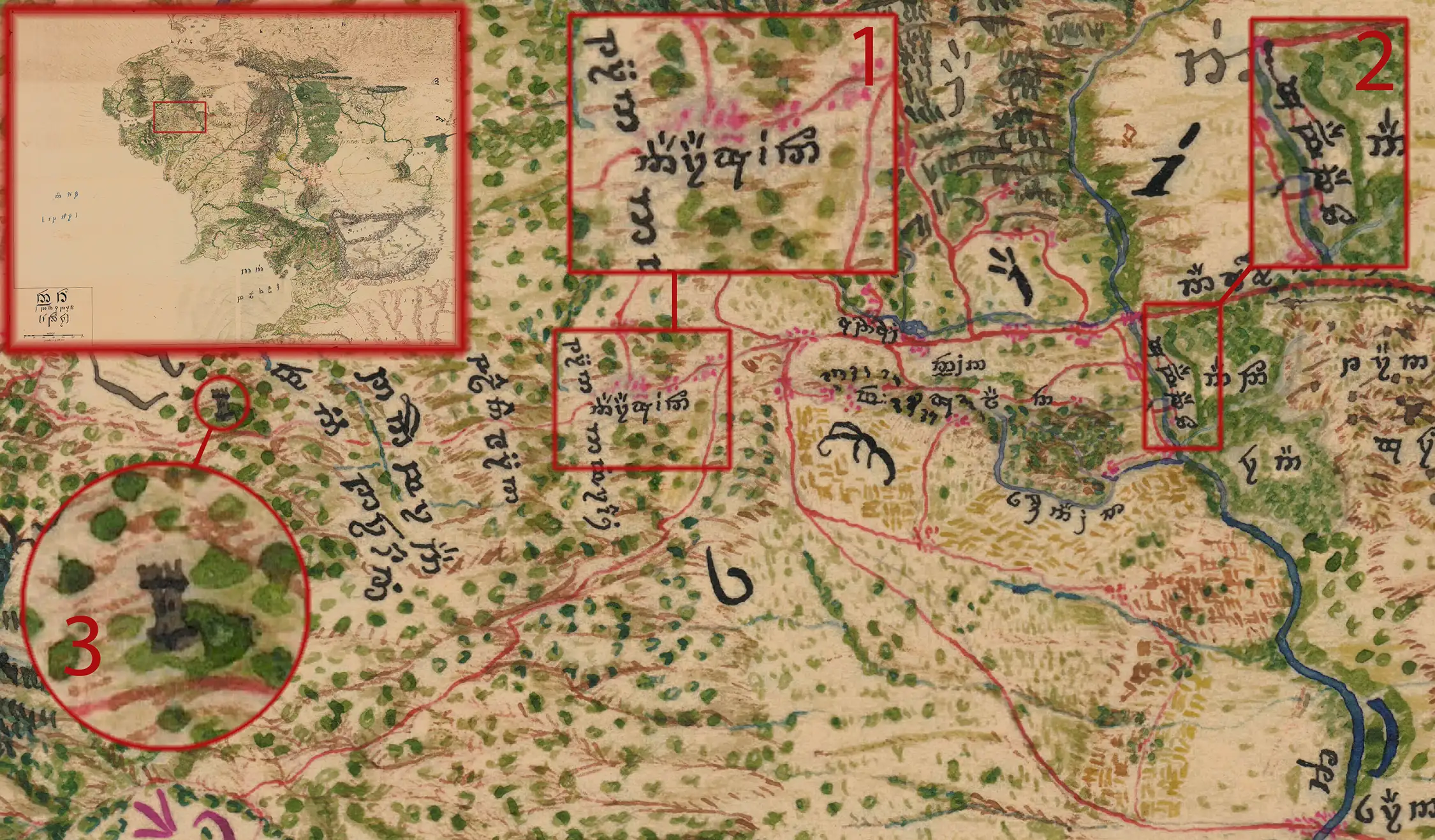
The Shire
The Shire is among the best-documented regions of Middle-earth. It benefits from extensive descriptions in both The Hobbit and The Lord of the Rings, as well as Tolkien’s own detailed map, 'A Part of the Shire.' Drawing upon these rich sources, the anonymous cartographer includes many of its most beloved landmarks, among them Hobbiton, the High Hay beside the Old Forest, and the distant towers beyond the western bounds.
Hobbiton (1) lies in the rolling countryside of the Westfarthing, gathered around the Hill beneath which Bilbo and Frodo lived at Bag End. Tolkien describes its lanes, gardens, mills, inns, and hobbit-holes across several chapters, while his illustration 'The Hill: Hobbiton-across-the-Water' supplies additional visual detail. More than any other settlement, Hobbiton embodies the sheltered, cultivated character of the Shire—and provides the homely point from which both Bilbo’s and Frodo’s journeys begin.
The Hedge, properly called the High Hay, stood at the opposite end of the Shire-country, along the eastern boundary of Buckland. More than twenty miles long, it was planted and continually maintained by the Bucklanders as a defense against the Old Forest. In 'A Conspiracy Unmasked' and 'The Old Forest,' Frodo and his companions pass through a guarded tunnel beneath it. The Hedge is therefore both a physical fortification and a symbolic boundary: on one side lie farms, lanes and ordered habitations; on the other begins an ancient primal landscape.
The Tower Hills, or Emyn Beraid, rise beyond the Far Downs at the Shire's western edge. Tolkien describes three White Towers there, built by Gil-galad for Elendil before the end of the Second Age. The tallest and westernmost was Elostirion, which held a palantír that looked westward across the Sea. Although the cartographer depicts what appears to be a solitary old watchtower or abandoned ruin, Tolkien’s account is more specific: there were three Elvish towers, and Elostirion still stood at the end of the Third Age. The Hobbits of the Westfarthing believed that the Sea could be seen from its summit, though none was known to have climbed it. The hills originally lay outside the Shire, but in the Fourth Age the Westmarch was added to Hobbit territory, making the Tower Hills its new western boundary.
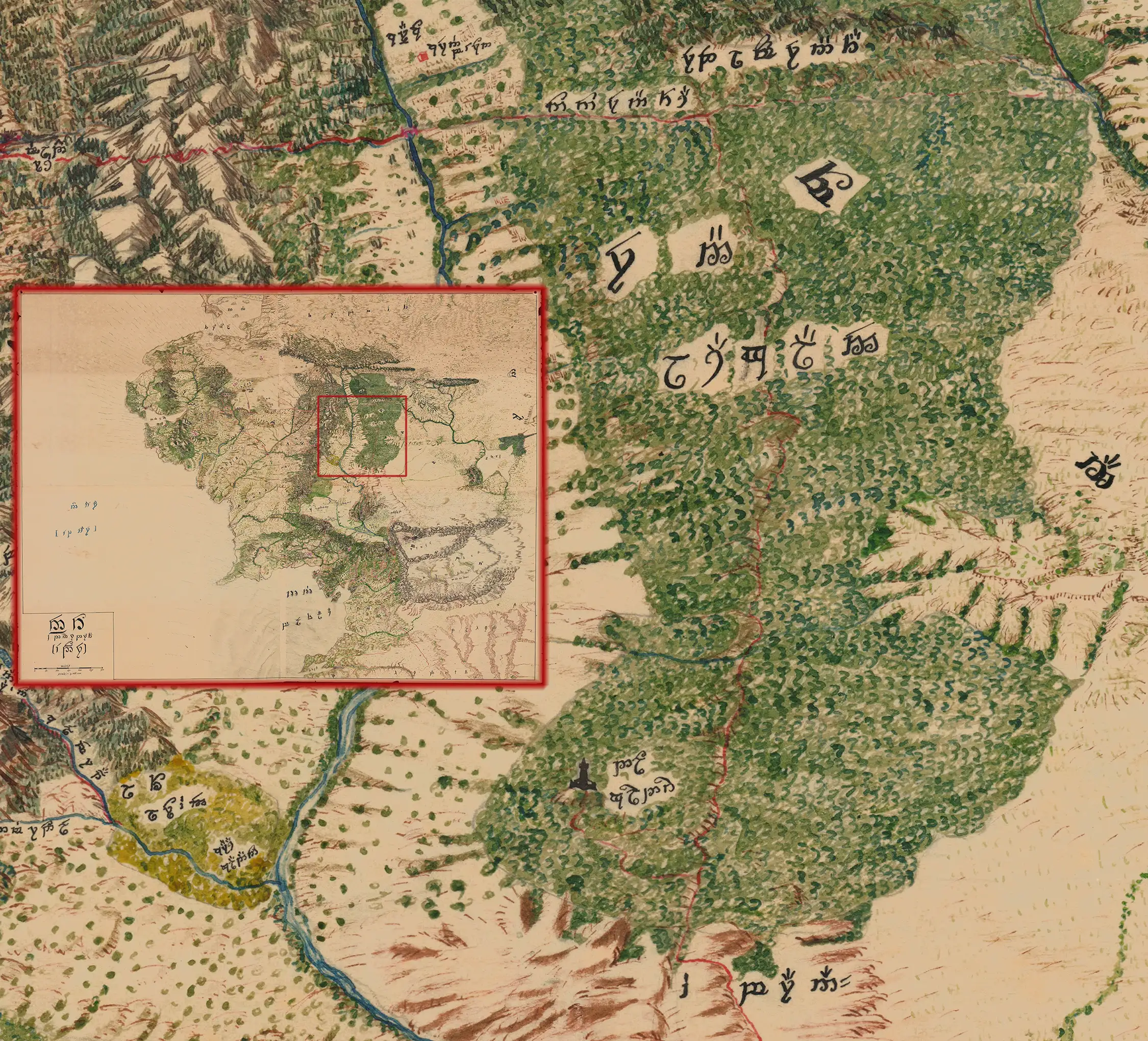
The Roads of Mirkwood
The map includes the northern Elf-path followed by Bilbo and Thorin’s company, but its principal focus here is the more southerly Old Forest Road, also called the Dwarf-road or Men-i-Naugrim, 'Way of the Dwarves.' This ancient east–west route once connected the lands of the Longbeards beyond the Misty Mountains with Erebor and the Iron Hills. By the time of The Hobbit, however, it had become overgrown and dangerous, which is why Beorn directs the company to the Elf-path farther north.
The anonymous mapmaker extends this known road into a wider network. A north-south route connects Men-i-Naugrim with Dol Guldur, Sauron's fortress in southern Mirkwood, before continuing toward the Morannon, the Black Gate of Mordor. Tolkien never maps a continuous road between these places, but the connection is a reasonable interpretation of the Legendarium. Dol Guldur housed Sauron, the Nazgûl, soldiers, spies, and supplies; it later served as the base for attacks upon Lórien and Thranduil’s realm. Some dependable line of communication with Mordor must therefore have existed.
The approaches to the Morannon are described in The Two Towers as a convergence of roads crossing the Dagorlad, including one extending northward. By carrying this route to Dol Guldur and ultimately connecting it with the Old Forest Road, the mapmaker transforms Tolkien's scattered geographical and military clues into a coherent strategic highway. The result is a thoughtful interpretation of the text, supplying the infrastructure implicitly required by the movement of Sauron's forces and servants between Mordor and his stronghold in southern Mirkwood.
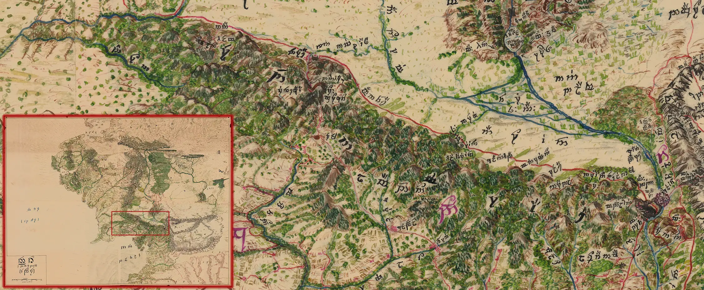
The Seven Beacons of Gondor
Here, the mapmaker details the White Mountains, naming the seven warning beacons of Gondor. Beginning near Minas Tirith, the stations form a chain running westward toward Rohan, allowing an alarm to travel rapidly across the kingdom through successive signal fires.
From east to west, beginning with the beacon nearest Minas Tirith, the seven beacon-hills are:
- Amon Dîn
- Eilenach
- Nardol
- Erelas
- Min-Rimmon
- Calenhad
- Halifirien, also called Amon Anwar
In The Return of the King, Gandalf sees the fires moving along precisely this route: from Amon Dîn and Eilenach, then west through Nardol, Erelas, Min-Rimmon and Calenhad, until the signal reaches Halifirien on the borders of Rohan. The system resembles the historical beacon chains of medieval England and Byzantium, where hilltop fires carried warnings across great distances. Tolkien, however, gives the final station an added weight: Halifirien was the sacred hill associated with the ancient treaty oath between Gondor and Rohan. The advancing line of fire therefore carries more than news of danger - it awakens an ancient alliance.
Cultivated Fields of Mordor
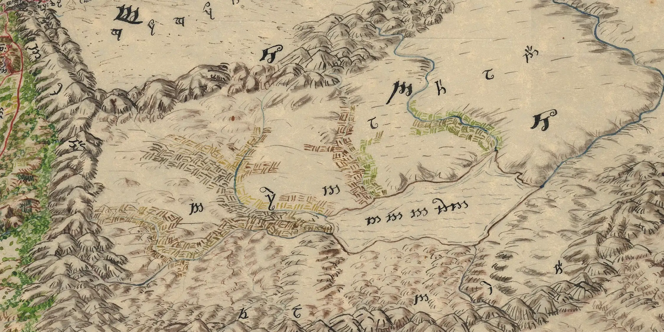
The mapmaker here attempts to visualize one of the most intriguing landscapes that Tolkien describes but never actually depicts on his published maps: the agricultural lands of Nurn surrounding the Sea of Núrnen in southern Mordor. In The Return of the King, Frodo and Sam look across the seemingly sterile northern wastes and wonder how Sauron could possibly feed his enormous armies. Tolkien supplies the answer, explaining that they knew nothing of the "great slave-worked fields away south", lying beside the "dark sad waters of Lake Núrnen." He further describes great roads extending east and south toward tributary territories, along which Sauron's forces carried supplies, plunder, and captives into Mordor. Thus, Tolkien conceived Mordor not simply as an unbroken volcanic wasteland, but as an organized imperial economy: mines, forges, and military concentrations in the north, supported by agricultural production in the more fertile south.
None of this agricultural geography was delineated on Tolkien's maps, leaving the mapmaker to translate the textual description into a plausible physical landscape. Here, the rivers flowing into the Sea of Núrnen are bordered by extensive patterns of cultivated fields, concentrated particularly along the waterways and lowlands where agriculture would logically have been possible. This is therefore not an arbitrary embellishment, but an informed cartographic interpretation of Tolkien's text—giving visible form to the otherwise unmapped agricultural infrastructure that sustained Sauron's war machine. The interpretation receives a final confirmation after Sauron's defeat, when Aragorn "gave to them all the lands about Lake Núrnen" - the former slaves becoming owners of the very country they had been forced to cultivate.
Near and Far Harad
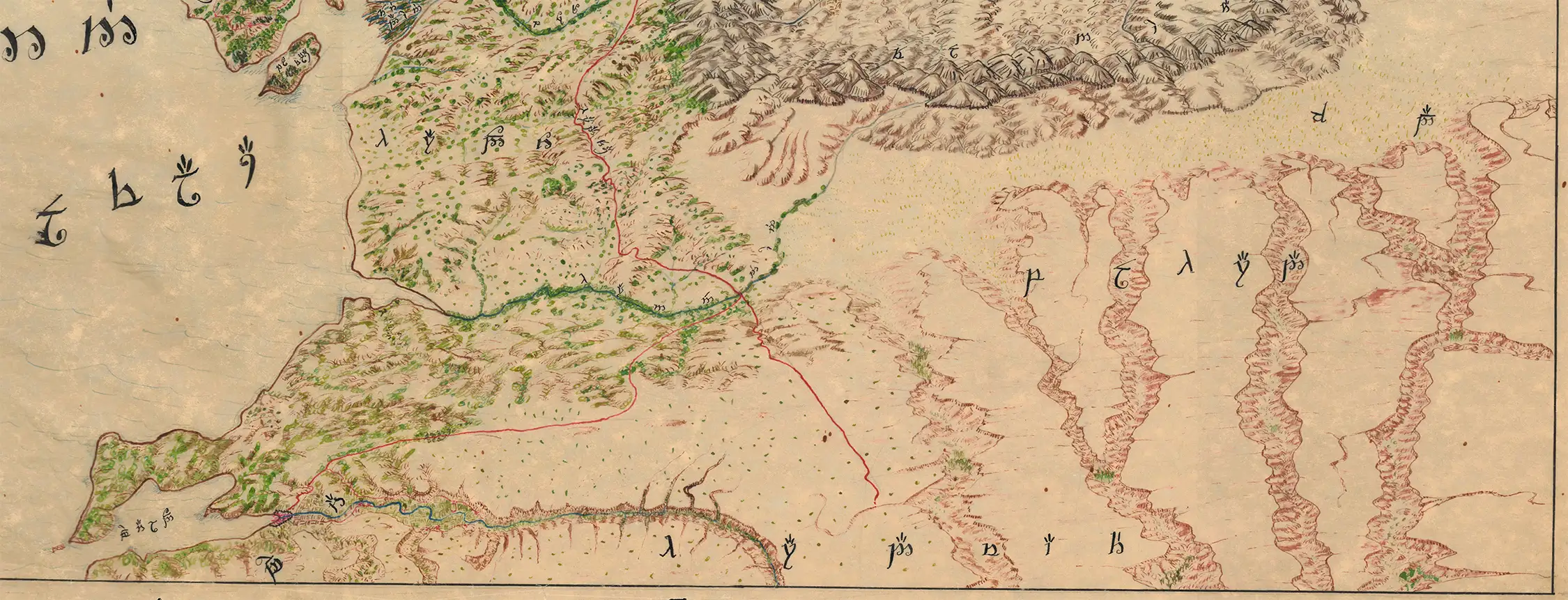
Here, the unknown mapmaker ventures beyond Tolkien's mapped geography to give substance to Umbar, Haradwraith, Near and Far Harad, and Khand, lands that remain tantalizingly indistinct in The Lord of the Rings. Tolkien offers fragments rather than a coherent geography. Aragorn remembers having journeyed "far into the South" and into countries "where the stars are strange.” At the same time, Sam encounters a Southron whose "scarlet robes", "corslet of overlapping brazen plates," and "black plaits of hair braided with gold" evoke a wealthy and culturally distinct civilization somewhere beyond Gondor.
Most suggestive are the mûmakil of Umbar: enormous beasts that appear at Minas Tirith "like moving houses" and later stand upon the Pelennor "like towers of defence", with the Haradrim rallying around them. From these scattered clues, the cartographer has imagined western Near Harad and the country surrounding Umbar as comparatively lush and fertile, threaded with rivers and vegetation. Tolkien never explicitly maps such a landscape, but the inference is compelling: a country capable of sustaining large populations, armies, horses, cities, fleets, and above all herds of gigantic mûmakil could hardly have been an undifferentiated desert.
The mapmaker becomes still more imaginative as he moves eastward into Near and Far Harad. Tolkien tells us remarkably little about its physical geography, even while emphasizing its remoteness and otherness: at the Pelennor there arrive "Southrons in scarlet" and warriors "out of Far Harad," peoples drawn from regions so distant that they seem almost beyond the geographical horizon of the narrative. The cartographer translates that literary remoteness into physical geography. Fertile western Harad gradually yields to a vast, arid interior of escarpments, ravines, isolated plateaus, and canyon-like valleys. None of these features derives directly from Tolkien's maps. Rather, they constitute an attempt to map the blank spaces Tolkien deliberately left south and east of the principal theater of his story.
The roads are perhaps the most revealing expression of this interpretive method. Tolkien repeatedly makes clear that the Southrons are not merely distant peoples known by rumor: large organized armies actually make the long march north. Sam, contemplating a slain Haradrim soldier in Ithilien, wonders "where he came from" and what had led him on "the long march from his home." At the Pelennor the scale becomes explicit: the Rohirrim find themselves "thrice outnumbered by the Haradrim alone," while the Southrons prove "bold men and grim, and fierce in despair."
Armies of such magnitude, arriving from countries hundreds of miles to the south, imply roads, supply systems, staging points, and established lines of communication. The mapmaker accordingly extends a coherent network northward from Harad and Umbar toward Mordor and the Black Gate, supplying cartographically the infrastructure that Tolkien's narrative requires but his maps omit.
In this sense, the mapmaker reverse-engineers the geography from Tolkien's story. The fertile country around Umbar explains the population, maritime power, and mûmakil; the increasingly harsh eastern landscape gives physical expression to the mysterious remoteness of Far Harad; and the roads explain how Sauron could summon enormous southern armies into Mordor and Gondor. Tolkien supplied glimpses: a Southron's scarlet clothing, the "long march from his home," the strange southern stars, the mûmakil "like moving houses," and armies arriving from lands beyond the edge of his maps. The cartographer's achievement was to read between those lines and turn them into geography.
In Summation
Taken as a whole, this manuscript map is far more than a fan-made enlargement of Tolkien's familiar maps. Its anonymous creator approached Middle-earth exactly as historical cartographers approached the just-discovered Americas or the unknown interiors of Africa and Asia: beginning with established geography, searching the texts for scattered evidence, and then cautiously filling the spaces. Roads are extended where armies and messengers must have traveled; cultivated fields appear where Tolkien tells us Sauron's slaves produced food; distant Harad acquires landscapes capable of supporting the peoples, cities, armies, and mûmakil described in the narrative. Even where the cartographer's conclusions are necessarily speculative, they reveal a sustained attempt to make Tolkien's world geographically coherent.
That achievement is all the more extraordinary if, as we suspect, the map dates from the 1960s-70s. Its maker worked before the Internet and before the publication of much of the posthumous Tolkien material now available to scholars, yet mastered Tengwar, engaged seriously with Sindarin and Quenya, and pursued obscure textual references far beyond the places shown on Tolkien's published maps. The result occupies a fascinating territory between cartography, scholarship, and imaginative reconstruction. Tolkien created a world whose geography extends beyond what he chose to draw; this unknown mapmaker attempted to discover what might lie in those blank spaces. In doing so, they produced not simply a map of Middle-earth, but a visual record of one reader's extraordinarily deep engagement with Tolkien's world.
Use the link below to explore the map for yourself with our zoom technology.
Related Posts and Information
https://www.geographicus.com/P/AntiqueMap/middleearthendor-elvish-1960