
Asahi Shimbun (sold)
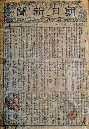
The Asahi Shimbun (朝日新聞; January 25, 1879 – Present), translated Morning Sun Newspaper, is one of Japan's oldest and most venerable daily newspapers. The Asahi Shimbun began publication in Osaka on January 25, 1879 as a small-print, four-page illustrated paper. The paper was founded by Kimura Noboru (company president), Murayama Ryōhei (owner), and Tsuda Tei (managing editor). In 1888 the newspaper expanded with a branch in Tokyo and began issuing the Tokyo Asahi Shimbun. The the Osaka and Tokyo papers formally merged under a single imprint in 1940. Almost from its inception the newspaper was known for its liberal views. The Asahi Shimbun continues to publish from Osaka today.
Map of Taiwan shorlty after the Treaty of Shimonoseki.
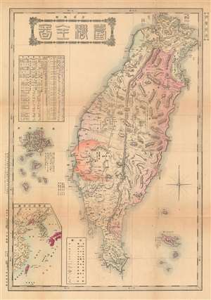
台灣全圖 / Complete Map of Taiwan.
sold
- Digital Map Information
- Suitable for large format printing
- File Size: 42.96 MB
- File Type: ZIP / TIFF
- ICC color profile embedded
- Delivered instantly via download link
This is a rare Meiji 28 1895 map of Taiwan or Formosa issued shortly after the April 17 signing of the Treaty of Shimonoseki, which formally ended the First Sino-Japanese War (August 1, 1894 – April 17, 1895). The map covers all of Taiwan with a clear division between eastern and western territories. At the time western Formosa, or Taiwan (臺灣) was primarily Chinese, while Formosa east of the Central Mountain Range, Banchi (蕃地) consisted of unexplored indigenous tribal lands. The coverage extends to the Penghu Islands, or Pescadores, which were ceded to Japan as part of the treaty. In the upper right, an inset submap illustrates Taiwan in relation to Fujian China, from which it was governed under the Qing.
This map is part of a series of maps issued in 1895, both before and after the treaty, typically by private newspapers, book stores, and enterprising publishers, to capitalize on Japanese public interest in Taiwan. All are quite rare and significant in illustrating the events of this ephemeral period. (more details)
This map is part of a series of maps issued in 1895, both before and after the treaty, typically by private newspapers, book stores, and enterprising publishers, to capitalize on Japanese public interest in Taiwan. All are quite rare and significant in illustrating the events of this ephemeral period. (more details)
Map of Korea drawn just after the Japan–Korea Annexation Treaty.
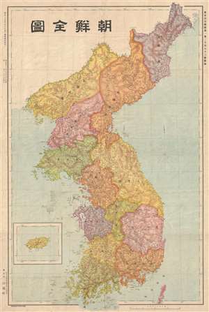
朝鮮全圖 / Map of Korea.
sold
- Digital Map Information
- Suitable for large format printing
- File Size: 12.11 MB
- File Type: ZIP / TIFF
- ICC color profile embedded
- Delivered instantly via download link
This uncommon 1910 map of Korea was issued following the Japan–Korea Annexation Treaty, the agreement that formally annexed Korea as part of Japan. The map covers all of Korea, including modern day North Korea and South Korea. This 1910 annexation began what is ... (more details)
Japan reimages itself on the world stage!
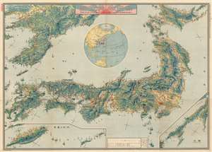
Bird's eye view of the New Japan. / 新日本鳥瞰圖
sold
- Digital Map Information
- Suitable for large format printing
- File Size: 143.63 MB
- File Type: ZIP / TIFF
- ICC color profile embedded
- Delivered instantly via download link
This is a rare and stunningly produced Taisho 10 or 1921 map of the Japanese Empire, including Taiwan and Korea, issued by the daily Tokyo Asahi Shimbun. The map uses a bird's-eye view model to illustrate the Japanese islands as well as Japanese imperial claims in Korea, Taiwan, The Ryukyu's, and Karafuto (Sakhalin). A globe appears a center, situating Japan in a global context. Red lines illustrate the empire-wide railroad network, with stops and connections identified throughout. (more details)
Sugoroku Map game celebrating the historic 1925 biplane flight from Tokyo to Rome.
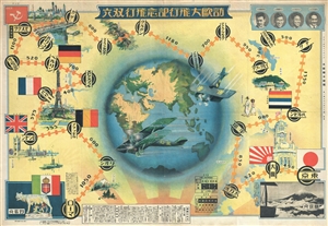
歐訪大飛行記念飛行遊戯 / Ōhō daihikō kinen hikō yūgi / Great European Visit Memorial Flight Game.
sold
- Digital Map Information
- Suitable for large format printing
- File Size: 20.18 MB
- File Type: ZIP / TIFF
- ICC color profile embedded
- Delivered instantly via download link
A colorful Taisho 14 or 1925 Japanese pictorial map of the world and sugoroku game. This map and game board depicts the western hemisphere surrounded by a secondary shadow map of the world. It was issued by the Japanese newspaper Asahi Shimbun as a supplement to ... (more details)
Sugoroku Map game celebrating the historic 1925 biplane flight from Tokyo to Rome.
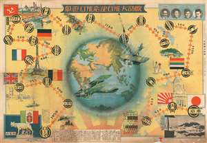
歐訪大飛行記念飛行遊戯 / Ōhō daihikō kinen hikō yūgi / Great European Visit Memorial Flight Game.
sold
- Digital Map Information
- Suitable for large format printing
- File Size: 77.5 MB
- File Type: ZIP / TIFF
- ICC color profile embedded
- Delivered instantly via download link
A colorful and uncommon Taisho 14 or 1925 Japanese pictorial map of the world and sugoroku game. This map and game board depicts the western hemisphere surrounded by a secondary shadow map of the world. It was issued by the Japanese newspaper Asahi Shimbun as a supplement to their December 10th, 1925 daily. This impressive image celebrates the first flight from Japan to Europe, a venture that was sponsored by the Asahi Shimbun to celebrate Japan's embrace of western technology. Although little known outside of Japan, this flight is of great historic importance and can be counted as one of the great feats of early aviation, comparable to Charles Lindberg's 1927 flight across the Atlantic. (more details)
Manchukuo, just prior to its formal establishment.
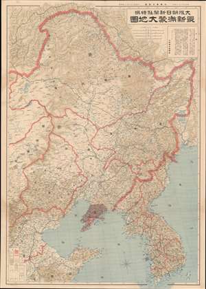
最新满蒙大地圖 / [Latest Map of Manchuria and Mongolia].
sold
- Digital Map Information
- Suitable for large format printing
- File Size: 58.99 MB
- File Type: ZIP / TIFF
- ICC color profile embedded
- Delivered instantly via download link
This is a rare 1932 map of Manchuria, including parts of Mongolia and northern China, published in the Osaka Asahi Shimbun (大阪朝日新聞) to mark the founding of the Japanese puppet state of Manchukuo. Japan's de facto colony was massive, more than double the land area of the Japanese home islands, and served as a frontier rich in resources and opportunity for the land scarce, resource-starved, overpopulated home islands. Therefore, this map was meant to familiarize the readers with this vast new territory but also advertise it as a destination for capital and settlers. (more details)
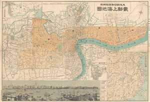
An iconic map of Shanghai, China, featuring a dramatic panoramic photograph of the Bund.
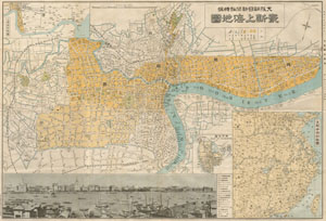
Saishin Shanhai chizu. Ōsaka Asahi Shinbunsha tokusen. / 大阪朝日新聞社特撰 . 最新上海地圖. / Osaka Asahi Shimbun Special Selection. Newest Map of Shanghai.
sold
- Digital Map Information
- Suitable for large format printing
- File Size: 4.26 MB
- File Type: ZIP / TIFF
- ICC color profile embedded
- Delivered instantly via download link
This is a rare and beautiful Showa 7 or1932 map of Shanghai, China. This map was issued by the Japanese daily, Osaka Asahi Shimbun , to illustrate events associated with the 'January 28 Incident' or 'Shanghai Incident' (January 28 – March 3, 1932), a conflict ... (more details)
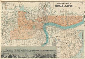
An iconic map of Shanghai, China, featuring a dramatic panoramic photograph of the Bund.
Saishin Shanhai chizu. Ōsaka Asahi Shinbunsha tokusen. / 大阪朝日新聞社特撰 . 最新上海地圖. / Osaka Asahi Shimbun Special Selection. Newest Map of Shanghai.
sold
- Digital Map Information
- Suitable for large format printing
- File Size: 19.51 MB
- File Type: ZIP / TIFF
- ICC color profile embedded
- Delivered instantly via download link
This is a rare and beautiful Showa 7 or1932 map of Shanghai, China. This map was issued by the Japanese daily, Osaka Asahi Shimbun , to illustrate events associated with the 'January 28 Incident' or 'Shanghai Incident' (January 28 – March 3, 1932), a conflict ... (more details)
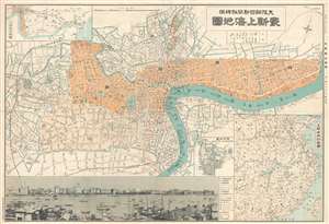
An iconic map of Shanghai, China, featuring a dramatic panoramic photograph of the Bund.
Saishin Shanhai chizu. Ōsaka Asahi Shinbunsha tokusen. / 大阪朝日新聞社特撰 . 最新上海地圖. / Osaka Asahi Shimbun Special Selection. Newest Map of Shanghai.
sold
- Digital Map Information
- Suitable for large format printing
- File Size: 22.46 MB
- File Type: ZIP / TIFF
- ICC color profile embedded
- Delivered instantly via download link
This is a rare and beautiful Showa 7 or 1932 map of Shanghai, China. This map was issued by the Japanese daily, Osaka Asahi Shimbun , to illustrate events associated with the 'January 28 Incident' or 'Shanghai Incident' (January 28 – March 3, 1932), a ... (more details)
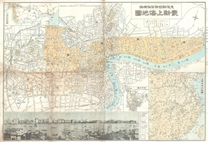
An iconic map of Shanghai, China, featuring a dramatic panoramic photograph of the Bund.
Saishin Shanhai chizu. Ōsaka Asahi Shinbunsha tokusen. / 大阪朝日新聞社特撰 . 最新上海地圖. / Osaka Asahi Shimbun Special Selection. Newest Map of Shanghai.
sold
- Digital Map Information
- Suitable for large format printing
- File Size: 22.61 MB
- File Type: ZIP / TIFF
- ICC color profile embedded
- Delivered instantly via download link
This is a rare and attractive Showa 7 or 1932 Osaka Asahi Shimbun map of Shanghai, China. Printed in the 7th year of Hirohito's reign (Showa 7), it depicts downtown Shanghai including the Chinese Quarter, the French Concession, the English Quarter (along the Bund), etc. Important buildings along the Bund are carefully noted, including the first HSBC Bank, the British Club, the Palace Hotel (Swatch Art Peace Hotel), Sassoon House (Fairmont Peace Hotel), and the Customs House. There is also a lovely vintage panoramic photo of the Bund along the bottom of the map. A small inset map of Nanjing or Nanking is also included in the lower right quadrant of the map. Another larger inset shows a regional map. Most of the text is written in both Japanese and English. (more details)
An iconic map of Shanghai, China, featuring a dramatic panoramic photograph of the Bund.
Saishin Shanhai chizu. Ōsaka Asahi Shinbunsha tokusen. / 大阪朝日新聞社特撰 . 最新上海地圖. / Osaka Asahi Shimbun Special Selection. Newest Map of Shanghai.
sold
- Digital Map Information
- Suitable for large format printing
- File Size: 16.55 MB
- File Type: ZIP / TIFF
- ICC color profile embedded
- Delivered instantly via download link
This is an uncommon and attractive 1932 map of Shanghai China. It was made before the start of the second Sino-Japanese war and World War II. Printed in the 7th year of Hirohito's reign, it depicts downtown Shanghai including the Chinese Quarter, the ... (more details)
Japan's growing empire on the eve of World War II.
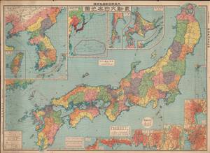
最新大日本地圖 / [Latest Map of Japan].
sold
- Digital Map Information
- Suitable for large format printing
- File Size: 90.24 MB
- File Type: ZIP / TIFF
- ICC color profile embedded
- Delivered instantly via download link
This is a large 1933 map of Japan (including Korea, Taiwan, Hokkaido, the Ryukyus, and other colonial possessions) published as an addendum to the Osaka Asahi Shimbun (大阪朝日新聞). It provides a great deal of geographic and economic information about the different parts of the Japanese Empire on the eve of World War II, just as the Japanese military was embarking on new conquests that would eventually lead to the destruction of the empire. (more details)
Military and economic power on the eve of World War II.
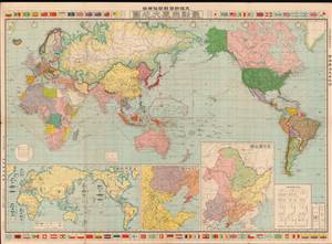
最新世界大地圖 / [Latest World Map].
sold
- Digital Map Information
- Suitable for large format printing
- File Size: 76.69 MB
- File Type: ZIP / TIFF
- ICC color profile embedded
- Delivered instantly via download link
This is a 1933 world map published by the Osaka Asahi Shimbun in the early phase of the Second Sino-Japanese War, an antecedent to and later a theater of World War II. The global tensions that would define World War II are evident here, particularly in the inset map at bottom-left showing the relative military strength of major powers. (more details)
Military and economic power on the eve of World War II.
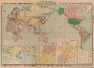
最新世界大地圖 / [Latest World Map].
sold
- Digital Map Information
- Suitable for large format printing
- File Size: 77.29 MB
- File Type: ZIP / TIFF
- ICC color profile embedded
- Delivered instantly via download link
This is a 1933 world map published by the Osaka Asahi Shimbun in the early phase of the Second Sino-Japanese War (1937 - 1845), an antecedent to and later a theater of World War II (1939 - 1945). The global tensions that would define World War II are evident here, particularly in the inset map at bottom-left showing the relative military strength of major powers. (more details)
An Alliance of Non-White Peoples.
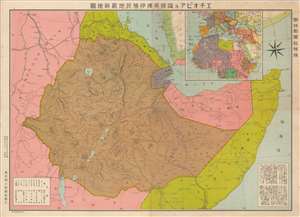
Latest Map of Ethiopia and neighboring British, French and Italian colonies. / エチオピア及隣接英佛伊殖民地最新地圖
sold
- Digital Map Information
- Suitable for large format printing
- File Size: 22.05 MB
- File Type: ZIP / TIFF
- ICC color profile embedded
- Delivered instantly via download link
An intriguing September 1935 Japanese map of Ethiopia at the outbreak of the Second Italo-Ethiopian War (1835 - 1837). Illustrating a little-known episode in pre-WWII history wherein Japan was attempting to create an 'Alliance of Non-White Peoples.' The map covers all of modern-day Ethiopia, as well as parts of Eretria, Somalia, Djibouti, Sudan, and Kenya. An inset in the upper right situates Ethiopia in the context of North Africa, and a text block in the lower right descripts the people and geography. (more details)
Pre-War Map of Shanghai illustrating the situation in the city between the first and second phases of the Battle of Shanghai.
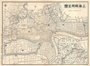
上海戰局全圖 / Shanghai Full War Map. / Shànghǎi zhànjú quán tú.
sold
- Digital Map Information
- Suitable for large format printing
- File Size: 8.53 MB
- File Type: ZIP / TIFF
- ICC color profile embedded
- Delivered instantly via download link
A scarce pre-World War II map of Shanghai, China, issued by the Osaka Asahi Shimbun in 1937 or Showa 12, issued during the Battle of Shanghai (August 13, 1937). Centered on the riverfront Bund Distract, this map covers the heart of modern Shanghai. ... (more details)
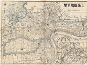
Shanghai.
sold
- Digital Map Information
- Suitable for large format printing
- File Size: 10.52 MB
- File Type: ZIP / TIFF
- ICC color profile embedded
- Delivered instantly via download link
A scarce pre-World War II map of Shanghai, China, issued by the Osaka Asahi Shimbun in 1937 or Showa 12, during the Battle of Shanghai (August 13, 1937). Centered on the riverfront Bund Distract, this map covers the heart of modern Shanghai including the International Settlement and French Concession. Larger scale regional maps appear in the upper left and lower right corners. (more details)
One of World War II's forgotten fronts.
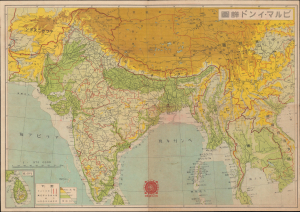
ビルマ - インド詳圖 / [Detailed Map of Burma and India].
sold
- Digital Map Information
- Suitable for large format printing
- Full resolution TIFF file
- ICC color profile embedded
- Delivered instantly via download link
This is a 1942 Asahi Shimbun Japanese map of Burma, India, and surrounding territories, made in the context of the Burma Campaign of World War II (1939 - 1945). When this map was published, Japanese forces were advancing northwards in Burma after having rapidly conquered the capital, Rangoon. It was issued to celebrate the victory and promote the war effort on the home front. (more details)
Includes an image of Lieutenant-General Percival's iconic walk to surrender British forces to the Japanese.
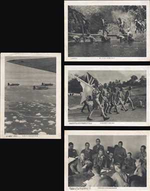
見會的史歷の伏降件條無軍英坡嘉新 / 體 - 工步に林密の古千 / る來使軍英てげ揭を旗白 / 擊爆大の鷲陸島坡嘉新
sold
- Digital Map Information
- Suitable for large format printing
- File Size: 20.44 MB
- File Type: ZIP / TIFF
- ICC color profile embedded
- Delivered instantly via download link
This is a set of four Asahi Shimbun press photographs from the Battle of Singapore. Each photograph illustrates a different aspect of the battle and the British surrender of the 'Gibraltar of the East'. Winston Churchill called the surrender of over ... (more details)
Cartoony cartography.
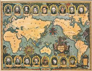
世界歷史地圖 明治十一年刊 新訂輿地全圖より / [World Historical Map, based on a map published in 1878, newly and fully revised].
sold
This is a playful cartoon world map published in the Asahi Shimbun in September 1979, based on a map published in the early Meiji period a century earlier. It shows portraits of important figures in the history of Japan's relations with the outside world, mostly from the Meiji period. (more details)