
Bünting, Heinrich (sold)

Heinrich Bünting (1545 – 1606) was a Protestant pastor and theologian. He was born in Hanover, and studied theology at the University of Wittenberg. He earned his Master's degree in 1569. He remained in Wittenberg as a pastor there, before being appointed to that same position at Alt Calenberg, in the service of the Dukes of Saxony. The estate was dissolved when the marriage of the Duchess Sidona and Duke Eric the Younger foundered, and Bünting became pastor in Gronau in 1575. In Gronau, he wrote his two major works - the 1581 Itinerarium Sacrae Scripturae, and the 1584 Brunswick and Lüneburg Chronicle. He produced a smaller work on Biblical coins and measures in 1582. He would briefly serve as superintendent in Goslar, but he would be dismissed as a result of theological differences. Stung, he returned to his hometown and changed to the less controversial profession of a beer brewer, until his death in 1606. The work for which he is best known, Itinerarium Sacrae Scripturae, was the first complete summary of biblical geography. It remained in print in more than sixty editions, long after his death. Earlier editions contain some of the most distinctive and sought after maps, most notably his map of the world in the shape of a cloverleaf, and an allegorical map of Asia in the form of a Pegasus.
A Most Unique Early Map of Jerusalem.
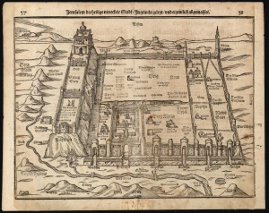
Jerusalem die heilige viereckete Stadt, in grund gelegt und eigentlich abgemahlet.
sold
- Digital Map Information
- Suitable for large format printing
- DPI: 600
- File Size: 31.55 MB
- File Type: ZIP / TIFF
- ICC color profile embedded
- Delivered instantly via download link
This is Heinrich Bünting's 1581 bird's-eye view of the Holy City of Jerusalem. Despite its schematic appearance, the plan was presented to Bünting's readers as depicting the city as being drawn as it was actually laid out - 'in Grundt gelegt und eigentlich abgemahlet'. This fascinating view appeared in Bünting's Itinerarium Sacrae, the first and for many years the only complete work of biblical geography. As such, this map's representation of Jerusalem would be for many years the armchair pilgrim's best view of the Holy City. (more details)
A Most Unique Early Map of Jerusalem.
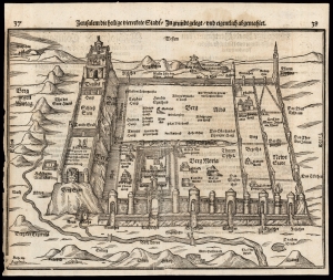
Jerusalem die heilige viereckete Stadt, in grund gelegt und eigentlich abgemalet.
sold
- Digital Map Information
- Suitable for large format printing
- DPI: 600
- File Size: 28.34 MB
- File Type: ZIP / TIFF
- ICC color profile embedded
- Delivered instantly via download link
This is Heinrich Bünting's 1581 bird's eye view of the Holy City of Jerusalem. Despite its schematic appearance, the plan was presented to Bünting's readers as depicting the city as being drawn as it was actually laid out - 'in Grundt gelegt und eigentlich abgemalet'. This fascinating view appeared in Bünting's Itinerarium Sacrae, the first and for many years the only complete work of biblical geography. As such, this map's representation of Jerusalem would be for many years the armchair pilgrim's best view of the Holy City. (more details)
Exodus of the Israelites.
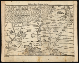
Reisen der Kinder Israel aus Egypten.
sold
- Digital Map Information
- Suitable for large format printing
- DPI: 600
- File Size: 29.86 MB
- File Type: ZIP / TIFF
- ICC color profile embedded
- Delivered instantly via download link
This is a Heinrich Bünting's 1581 map of the Holy Land, depicting the peregrination of the Israelites from Egypt to the Jordan River. The map illustrates the path of the Exodus, numbering the various stops. Biblical scenes are depicted in vignettes: Moses, having crossed the Red Sea, looks back at Egyptians drowning with their chariots; and the army of the Moabites can be seen fleeing their kingdom from the onslaught of the Israelites. The Mediterranean is decorated with a merman (although Laor maintained that this was a depiction of Jonah riding astride, rather than inside, the whale). There are also two giant fish, and a duck. (more details)
One of the most sought-after and unique printed maps of the world
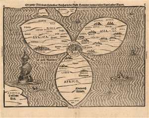
Die ganze Welt in ein Kleberblat, Welches in der Stadt Hannover, meines lieben Vaterlandes Wapen.
sold
- Digital Map Information
- Suitable for large format printing
- Full resolution TIFF file
- ICC color profile embedded
- Delivered instantly via download link
This is Heinrich Bünting's 1581 map of the world, dramatically presented as a clover leaf, in an early first block example. No other early map utilized this configuration. This beautiful woodcut appeared in Bünting's Itinerarium Sacrae, the first and for many years the only complete work of biblical geography. As such, this map's central positioning of Jerusalem and the Red Sea - recalling medieval mappamundae - is appropriate. The map's puzzling trefoil shape, with Asia, Africa and Europe each given a leaf, invokes Ptolemy's three parts of the world, as well as the medieval T-O map's tripartite form. The map's title, however, gives insight to Bünting's motivation for producing so singular an image: Die ganze Welt in ein Kleberblat, welches in der Stadt Hannover, Meines lieben Vaterlandes Wapen translates to:
The Whole World in a Cloverleaf, Which is the Arms of my Dear Fatherland, Hanover.Bünting is using the centerpiece map of his book to tip his hat to his home town. (more details)
Most Unique Early Map of the World.
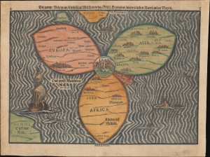
Die gantze Welt in ein Kleberblat, Welches ist der Stadt hannover / meines lieben Vaterlandes Wapen.
sold
- Digital Map Information
- Suitable for large format printing
- Full resolution TIFF file
- ICC color profile embedded
- Delivered instantly via download link
This is Heinrich Bünting's c. 1581-1585 iconic map of the world, dramatically presented as a clover leaf. This beautiful woodcut appeared in Bünting's Itinerarium Sacrae, the first and for many years the only complete work of biblical geography. (more details)
The Most Unique Early Map of the World
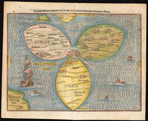
Die gantze Welt in ein Kleberblat, Welchs ist der stadt hannover, meines lieben Vaterlandes Wapen.
sold
- Digital Map Information
- Suitable for large format printing
- DPI: 600
- File Size: 12.76 MB
- File Type: ZIP / TIFF
- ICC color profile embedded
- Delivered instantly via download link
This is Heinrich Bünting's map of the world, dramatically presented as a clover leaf. No other early map utilized this configuration. This beautiful woodcut appeared in Bünting's Itinerarium Sacrae, the first and for many years the only complete work of biblical geography. As such, this map's central positioning of Jerusalem and the Red Sea - recalling medieval mappamundae - is appropriate. The map's puzzling trefoil shape, with Asia, Africa and Europe each given a leaf, invokes Ptolemy's three parts of the world, as well as the medieval T-O map's tripartite form. The map's title, however, gives insight to Bünting's motivation for producing so singular an image: Die gantze Welt in ein Kleeberblat, welches ist der Stadt Hannover, Meines lieben Vaterlandes Wapen translates to:
The Whole World in a Cloverleaf, Which is the Arms of my Dear Fatherland, Hanover.Bünting is using the centerpiece map of his book to tip his hat to his home town. (more details)
The Most Unique Early Map of the World.
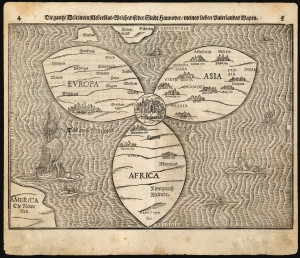
Die gantze Welt in ein Kleberblat, Welches ist der Stadt hannover / meines lieben Vaterlandes Wapen.
sold
- Digital Map Information
- Suitable for large format printing
- Full resolution TIFF file
- ICC color profile embedded
- Delivered instantly via download link
This is Heinrich Bünting's 1585 / 1597 iconic map of the world, dramatically presented as a clover leaf. This beautiful woodcut appeared in Bünting's Itinerarium Sacrae, the first and for many years the only complete work of biblical geography. (more details)
The World, Centered on the Holy Land
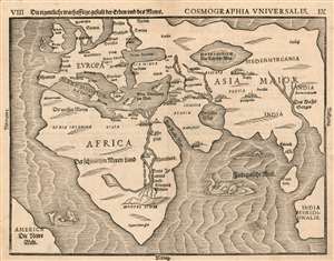
Die eigentliche warhafftige gestalt der Erden und des Meers. Cosmographia Universalis.
sold
- Digital Map Information
- Suitable for large format printing
- DPI: 600
- File Size: 13.84 MB
- File Type: ZIP / TIFF
- ICC color profile embedded
- Delivered instantly via download link
This is Heinrich Bünting's 1585 map of the world. Bünting's more famous 'cloverleaf' world was not so much a literal depiction of geography, as it was an expression of patriotic devotion (the cloverleaf was the sigil of his birth-city, Hanover.) This map, which appeared in the same work, does represent an effort to show the actual shape and positions of the continents as they were understood in the early 16th century. (more details)
Fascinating Allegorical Asia.
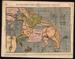
Asia Secunda Pars Terrae In Forma Pegasir.
sold
- Digital Map Information
- Suitable for large format printing
- Full resolution TIFF file
- ICC color profile embedded
- Delivered instantly via download link
This is one of the most famous cartographic curiosities: Heinrich Bünting's 1587 map of Asia in the form of the mythological winged horse, Pegasus. The horse's head is Asia Minor; its front legs form the Arabian Peninsula. Persia resembles a horse blanket. The hind legs represent the Indian and Malay peninsulas, while the spreading wings cover the northern steppe of Scythia and Tartaria. This beautiful woodcut appeared in Bünting's Itinerarium Sacrae, the first and, for many years, the only complete work of biblical geography. (more details)
Most Desirable Edition of Bünting's Biblical Geography.
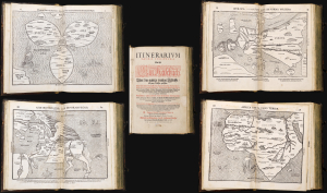
Itinerarium Sacrae Scripturae Das ist/ Ein Reisebuch, Uber die gantze heilige Schrifft in zwey Bücher getheilet. Das Erste Theil begreifft alle Reisen der lieben Patriachen/ Richter/ Könige/ Propheten ... Das Ander/ gehet auff das Newe Testament ... Zuuor gemehret mit einem büchlein DE MONETIS ET MENSVRIS... Insonderheit aber mit einer feinen nützlichen erklerung des Buchs Josua/ Durch M. Henricum Bünting/ Pfarherr der Kirchen zu Grunaw im Lande zu Brunshweig. Mit einer Vorrede des Herrn D. Martini Chemnitij.
sold
- Digital Map Information
- Suitable for large format printing
- Full resolution TIFF file
- ICC color profile embedded
- Delivered instantly via download link
This is a superb example of Heinrich Bünting's 1587 Itinerarium Sacrae Scripturae, the first complete work of biblical geography. This 1587 edition is the first to contain its full complement of figured maps of the continents. Africa, Europa Regina, and Asia-as-a-Pegasus first appear in this edition. Along with the famous cloverleaf world map, Die ganze Welt in einem Kleberblat, it is largely these figural maps for which this work is today most admired. Thus, this is the most desirable form in which this influential and long-lived book appears. (more details)
Regal Europe!
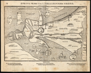
Europa Prima Pars Terrae In Forma Virginis.
sold
- Digital Map Information
- Suitable for large format printing
- Full resolution TIFF file
- ICC color profile embedded
- Delivered instantly via download link
This is Heinrich Bünting's 1589 / 1597 Europa Regina: a map of the continent of Europe, in the form of a woman. This striking woodcut appeared in Bünting's Itinerarium Sacrae, the first and for many years the only complete work of biblical geography. (more details)
Distinctive Woodcut map of Africa.
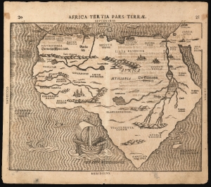
Africa Tertia Pars Terrae.
sold
- Digital Map Information
- Suitable for large format printing
- Full resolution TIFF file
- ICC color profile embedded
- Delivered instantly via download link
This is Heinrich Bünting's 1589 map of the continent of Africa. This striking woodcut appeared in Bünting's Itinerarium Sacrae, the first and for many years the only complete work of biblical geography. (more details)
Exodus of the Israelites.
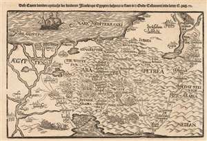
Dese Caerte vanden upttocht der kinderen Israels upt Egypten.
sold
- Digital Map Information
- Suitable for large format printing
- DPI: 600
- File Size: 5.5 MB
- File Type: ZIP / TIFF
- ICC color profile embedded
- Delivered instantly via download link
This is a scarce 1635 Dutch woodcut map of the Holy Land, depicting the peregrination of the Israelites from Egypt to the Jordan River. The map illustrates the path of the Exodus, numbering the various stops. Biblical scenes are depicted in vignettes: the parting of the Red Sea with the Egyptians in pursuit; the gathering of manna in the desert; Moses receiving the Ten Commandments whilst the Israelites worship the Golden Calf; and battle scenes. The Mediterranean is decorated with a fine sailing ship. (more details)