
Davies, Benjamin Rees (sold)

Benjamin Rees Davies (1789 - December 16, 1872) was an engraver, cartographer, painter, and map publisher active in the early to mid-19th century. Davies was born in Holborn, England, apprenticed as under John Lodge in 1803. He began publishing around 1811 and is known to have compiled many of own maps from original survey work. From approximately 1848 onward Davies published in conjunction with the Stanford Firm. He is also known to have engraved a number of maps for the Dispatch Atlas and the S.D.U.K. Davies was an early adopter of steel plate engraving and used the exceptional hardness of steel to create some of the most delicately engraved and beautifully produced maps of his era. He was quite famous in England for his detailed street plans of London, which he began publishing in 1848. Davies is known to have worked with numerous other cartographers of his period including French, Mexican, and American map makers. Many of his maps and plans continued to be published and updated posthumously well into the 1880s.

A New Map of London, Westminster, Southwark, and their suburbs.
sold
- Digital Map Information
- Suitable for large format printing
- DPI: 300
- File Size: 6.99 MB
- File Type: ZIP / TIFF
- ICC color profile embedded
- Delivered instantly via download link
An uncommon 1823 map of London, england, by Benjamin Davies. Centered on the Thames River, this map covers London from Chelsea to the east India Docks and from Regents Park to Greenwich Park. The map identifies all streets, parks, important buildings, docks, and ... (more details)
Features a view of Saint Basil's Cathedral.
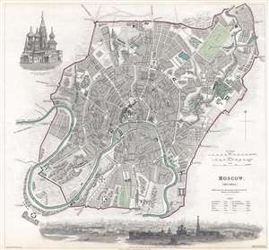
Moscow. (москвы.)
sold
- Digital Map Information
- Suitable for large format printing
- DPI: 300
- File Size: 6.39 MB
- File Type: ZIP / TIFF
- ICC color profile embedded
- Delivered instantly via download link
This is an 1836 Society for the Diffusion of Useful Knowledge (S.D.U.K.) city map or plan of Moscow, Russia. The map depicts the city from the Vogankovskaia Novaia Zastava (one of the gates in the city walls) to the Lake of Khapilovkoi and from St. Catherine's ... (more details)
A stunning map of an ancient city with a long history.
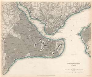
Constantinople. Stambool.
sold
- Digital Map Information
- Suitable for large format printing
- DPI: 300
- File Size: 7.13 MB
- File Type: ZIP / TIFF
- ICC color profile embedded
- Delivered instantly via download link
This is an 1840 Society for the Diffusion of Useful Knowledge (S.D.U.K.) city map or plan of Constantinople, today known as Istanbul. Once known as Byzantium, the city was renamed Constantinople after Emperor Constantine the Great. It soon became the capital ... (more details)
Boston, before the Back Bay.
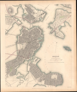
Boston with Charlestown and Roxbury.
sold
- Digital Map Information
- Suitable for large format printing
- File Size: 11.37 MB
- File Type: ZIP / TIFF
- ICC color profile embedded
- Delivered instantly via download link
This is an 1842 Society for the Diffusion of Useful Knowledge (S.D.U.K.) map of Boston. It provides a snapshot of the city in transition, in the early days of the railroad boom, but before much of the landfill that would give Boston its modern form. (more details)
Meticulously engraved map of London!
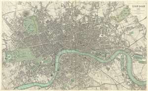
London 1843.
sold
- Digital Map Information
- Suitable for large format printing
- DPI: 300
- File Size: 20.02 MB
- File Type: ZIP / TIFF
- ICC color profile embedded
- Delivered instantly via download link
A beautiful 1843 map of London, England, from the 1844 Chapman and Hall edition of Maps of the Society for the Diffusion of Useful Knowledge . Updated from the original printing of 1835, this map covers central London from Buckingham Palace to the West ... (more details)
Plan of Boston Detailing the City Prior to the Filling of the Back Bay
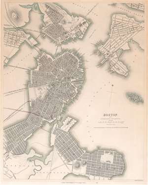
Boston with Charlestown and Roxbury.
sold
- Digital Map Information
- Suitable for large format printing
- DPI: 600
- File Size: 16.34 MB
- File Type: ZIP / TIFF
- ICC color profile embedded
- Delivered instantly via download link
This is an 1845 Society for the Diffusion of Useful Knowledge (S.D.U.K.) map of Boston and its vicinity. The map shows the city from Charlestown and the Chelsea Reach in the north, down to Dorchester and South Boston; the map reaches as far west as Lechmere and part of Roxbury, and as far east as roughly the intersection of Chelsea and East Eagle streets. Bird island appears in the harbor with the notation indicating that it is underwater at high tide. Forts, municipal structures and factories are marked on the map, as are gardens and commons. (more details)
A magnificently engraved and historic plan of London.
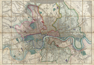
Davies's New Map of the British Metropolis, The Boundaries of the Boroughs, County Court Districts, Railways, and Modern Improvements.
sold
- Digital Map Information
- Suitable for large format printing
- DPI: 300
- File Size: 45.55 MB
- File Type: ZIP / TIFF
- ICC color profile embedded
- Delivered instantly via download link
A rare, extraordinary, and beautifully engraved 1852 case map or pocket plan of London, England, by B. R. Davies. Covers the center of London from Chiswick east to Bugsby's Reach and the Victoria Docks, extends north as far as Stamford Hill, and south ... (more details)
A colorful beautifully engraved map of London.
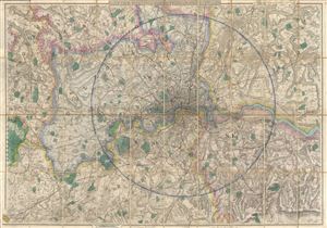
Davies's New Map of the Environs of London.
sold
- Digital Map Information
- Suitable for large format printing
- File Size: 57.5 MB
- File Type: ZIP / TIFF
- ICC color profile embedded
- Delivered instantly via download link
A beautifully engraved, impressively detailed, and colorful 1875 map of London by Benjamin Rees Davies. Centered on the Thames River valley, this map covers from Northaw to Grays Thurrock, and from Chipstead to Windsor. Names roads, farms, some ... (more details)
Beautifully engraved large format map of Victorian London.
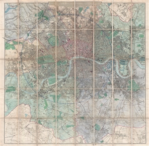
Davies's New Map of the British Metropolis. The Boundaries of the Boroughs, County Court Districts, Railways, and Modern Improvements.
sold
- Digital Map Information
- Suitable for large format printing
- File Size: 50.4 MB
- File Type: ZIP / TIFF
- ICC color profile embedded
- Delivered instantly via download link
A fine 1885 example of Davies's fine large scale map of London. Roughly centered on Charing Cross the Thames River, the map covers from Brent Reservoir to Bromley, and from New Wanstead to Cottenham Park. A shaded circular area at the center of ... (more details)