
Kodansha (sold)

Kodansha (株式会社講談社, 1909 - Present), also known in the early Shōwa period as Dai Nippon Yūbenkai Kōdansha (大日本雄弁会講談社), is a Japanese publishing house founded in 1909 by Seiji Noma (野間淸治). Seiji founded Kodansha as a spin-off from the Dai-Nippon Yūbenkai (Greater Japan Oratorical Society) and produced the literary magazine Yūben as its first publication. The name Kodansha, a derivative of the defunct magazine Kōdan Club (Storytelling Club), in 1911, which it merged with the Dai-Nippon Yūbenkai. In 1925, Kodansha launched King (キング) , the first magazine to sell 1,000,000 copies in its first printing. Kōdansha published several other magazines including Women's Club (婦人倶樂部) and Boy's Club (少年倶樂部) and had become a major shaper of Japanese culture and public opinion by the 1930s, controlling 70% of the magazine market. Kōdansha suffered difficulties during the war period, due to both intense censorship and the 1938 death of both Noma Seiji and his son, Noma Hasashi (野間恒), within weeks of one another. Still, the company survived the wartime era and, after a period of difficulties during the U.S. Occupation due to Kōdansha's endorsement of militarism, benefitted from a postwar publishing revival. Although King and other magazines ceased publication in the postwar period, Kōdansha branched into other areas, including manga and music recording, and is now the largest publisher in Japan.
Japan meets the world - an influence for the development of western pictorial cartography.
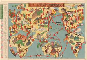
Round the World Competition. / 世界一週競争双六
sold
- Digital Map Information
- Suitable for large format printing
- File Size: 44.41 MB
- File Type: ZIP / TIFF
- ICC color profile embedded
- Delivered instantly via download link
A scarce 1926 Japanese 'round the world' sugoroku game and pictorial map of the world by Saburo Ota (太田三郎). The game board takes the form of an allegorical map of the world centered on Japan. The continents are amorphous but recognizable. Vignette illustrations throughout depicts cultural figures, architectural wonders, flora, fauna, and Japanese people engaging with the world. Three cities are specifically highlighted, Tokyo which acts as the starting point or furi-dashi), and New York and London, servings as optional endpoints or agari. The verso features an image of a 'family athletic meet.' (more details)
The trans-Pacfic aviation race.
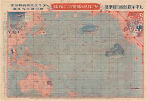
太平洋横断飛行競争盤 / Trans-Pacific Flight Game Board. / 城攻め一番乗り双六 / Castle Attack Sugoroku.
sold
- Digital Map Information
- Suitable for large format printing
- Full resolution TIFF file
- ICC color profile embedded
- Delivered instantly via download link
This is a rare 1927 (Showa 2) map and Sugoroku board drawn to promote Japanese ambitions to achieve the first solo trans-Pacific flight. The map was published by Dainippon Yutsukai Kodansha (大日本雄辯會講談社) as a New Year supplement to their 'Japanese Youth Club' periodical. The map is printed on both sides. The more interesting side (to us), is the trans-pacific flight Sugoroku. The opposite side features a brightly lithographed castle siege game. (more details)
'Kawaii' military expansionism.
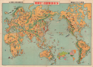
世界パノラマ大地圖 / World Panorama Map.
sold
- Digital Map Information
- Suitable for large format printing
- File Size: 194.97 MB
- File Type: ZIP / TIFF
- ICC color profile embedded
- Delivered instantly via download link
A remarkable 1933 Japanese issue pictorial map of the world drawn by Keizo Shimada (島田啓三). The map's cartoonish (manga) content seems deceptively innocent when this map is, ultimately, a propaganda piece underscoring nationalistic Japanese militarism in the lead up to the Second Sino-Japanese War (1937 - 1945) and World War II (1939 - 1945). (more details)
A uniquely Japanese combination of 'Kawaii' and military expansionism.
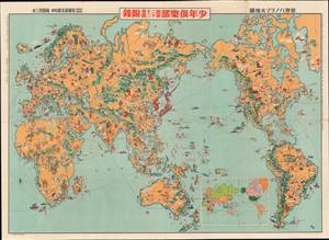
世界パノラマ大地圖 / World Panorama Map.
sold
- Digital Map Information
- Suitable for large format printing
- File Size: 58.72 MB
- File Type: ZIP / TIFF
- ICC color profile embedded
- Delivered instantly via download link
A remarkable 1933 Japanese issue pictorial map of the world drawn by Keizo Shimada (島田啓三). Centered on the Japanese Empire, which is highlighted in red and includes both Taiwan and Korea, this map extends to cover the entire world except for the Atlantic, which is only minimally addressed. (more details)
5 years before the Pearl Harbor Attack.
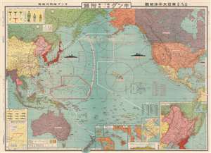
東亞太平洋地圖 / 非常時國防一覽 / East Asia Pacific Map / A National Defense View at a Special Time. / Hijōji kokubō ichiran tōa-taiheiyō-zu.
sold
- Digital Map Information
- Suitable for large format printing
- File Size: 78.23 MB
- File Type: ZIP / TIFF
- ICC color profile embedded
- Delivered instantly via download link
This is a fascinating and important 1935 (Showa 10) Nakata Fukuzou Pre-World War II Japanese propaganda map of the Pacific foreshadowing the Pearl Harbor attack, the Aleutian Islands Campaign, and the Philippine Campaign. Covering the entire Pacific, from the Bay of Bengal to New York and from the Bering Strait to New Zealand, this map anticipates the overarching Japanese strategy for World War II in surprising detail. (more details)
A map for the Japanese home front, marking the capture of Shanghai.
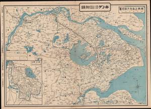
南京-上海地方詳細圖 / [Detailed Map of the Nanjing-Shanghai Region].
sold
- Digital Map Information
- Suitable for large format printing
- Full resolution TIFF file
- ICC color profile embedded
- Delivered instantly via download link
This is a 1937 map of the Nanjing-Shanghai region in China, published in the Japanese magazine King at the height of the fighting in that area during the Second Sino-Japanese War. It served as a means of familiarizing the Japanese home front with the geography of the battlefield in China. (more details)
Japan's opening offensive of the Second Sino-Japanese War.
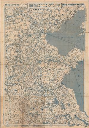
This is a 1937 Fuchida Tadayoshi map of China published in King (キング) magazine during the opening phase of the Second Sino-Japanese War (World War II). (more details)
Celebrating Japan's progress in the war against China.
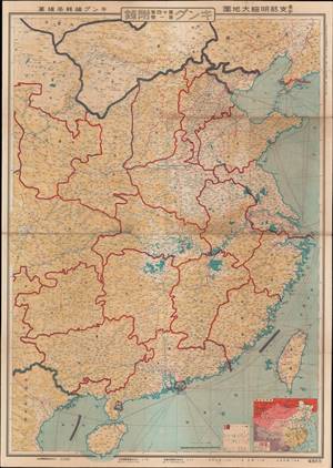
最新支那明細大地圖 / [Latest Detailed Map of China].
sold
- Digital Map Information
- Suitable for large format printing
- Full resolution TIFF file
- ICC color profile embedded
- Delivered instantly via download link
This is a scarce 1938 propaganda map of China published in the Japanese magazine King (キング) just after Japanese troops' captured Shanghai and Nanjing in the opening months of the Second Sino-Japanese War (World War II). (more details)
War Propaganda for kids.
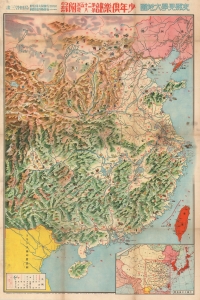
支那見學大地圖 / Large Study Map of China.
sold
- Digital Map Information
- Suitable for large format printing
- File Size: 82.41 MB
- File Type: ZIP / TIFF
- ICC color profile embedded
- Delivered instantly via download link
This is a rare 1938 (Showa 13) World War II or Second Sino-Japanese War manga-style propaganda map of China by a team of artists, printers, and editors led by Satō Yūtarō (佐藤裕太郎). Published for the magazine Youth Club (or Shōnen Club, 小年俱樂部), this map was meant to educate Japanese children about China and justify Japan's war there. (more details)
Japanese global perspective on the eve of World War II.
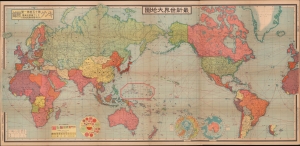
最新世界大地圖 / [Latest World Map].
sold
- Digital Map Information
- Suitable for large format printing
- Full resolution TIFF file
- ICC color profile embedded
- Delivered instantly via download link
This is a fascinating 1939 world map published by King magazine (キング) reflecting a Japanese perspective on geopolitics on the eve of World War II (1939 - 1945). The verso (back) includes two maps: one is a detailed map of China and Northeast Asia, where Japan was embroiled in a full-scale war, and the other is a map of Europe soon after the German occupation of the Sudetenland and the signing of the Munich Agreement. (more details)
Japanese Military Hardware on the Eve of the Pacific War.
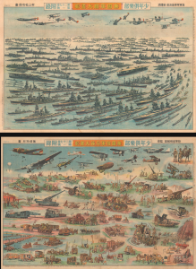
帝國軍艦大畫報 / 帝國陸軍兵器大畫報 / [Imperial Warship Pictorial / Imperial Army Weapons Pictorial].
sold
- Digital Map Information
- Suitable for large format printing
- Full resolution TIFF file
- ICC color profile embedded
- Delivered instantly via download link
This is a striking 1940 Shōnen Club double-sided sheet depicting Japanese military hardware during the Second-Sino Japanese War (1937 - 1945) and on the eve of the Pacific War (1941 - 1945), part of World War II. It reflects the degree to which militarism had become quotidian in Japan, on a total mobilization footing since 1938 due to its full-scale war in China. More subtly, it also represents the deep rivalry between the Imperial Japanese Navy (IJN) and Imperial Japanese Army (IJA) that hamstrung Japan's war effort. (more details)