
One of the more attractive 19th century commercial atlas maps of Washington D.C.
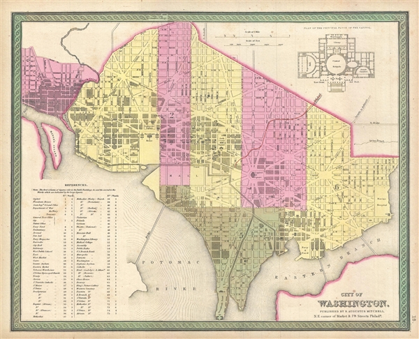
City of Washington
sold
- Digital Map Information
- Suitable for large format printing
- DPI: 300
- File Size: 5.43 MB
- File Type: ZIP / TIFF
- ICC color profile embedded
- Delivered instantly via download link
This is a fine example of Samuel Augustus Mitchell's 1849 map or plan of Washington D.C. Given that most of Washington D.C. was under construction when this map was drawn, Mitchell's plan is a remarkable combination of existing of existing cartography and future ... (more details)
Illegal Japanese news broadside 'Kawaraban' illustrating the momentous arrival of Commodore Perry in Edo or Tokyo Bay.

神國泰平 武守固鑑 / Shinkoku Taihei Take Mori Mata Akira
sold
- Digital Map Information
- Suitable for large format printing
- DPI: 300
- File Size: 10.89 MB
- File Type: ZIP / TIFF
- ICC color profile embedded
- Delivered instantly via download link
A rare c. 1854 Japanese news broadside describing the arrival American Commodore Mathew Perry in Edo Bay. The image depicts Edo or Tokyo Bay with southeast at the top of the map. Perry's ships, of which three including the Mississippi , his paddlewheel ... (more details)
The earliest obtainable map to name California!
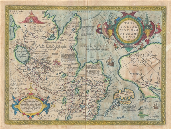
Tartariae Sive Magni Chami Regni typus.
sold
- Digital Map Information
- Suitable for large format printing
- DPI: 300
- File Size: 10.21 MB
- File Type: ZIP / TIFF
- ICC color profile embedded
- Delivered instantly via download link
The first state of Ortelius' important 1570 map of Tartary. Among other things, this map is notable as the earliest obtainable map to name California. The map covers from the Black Sea to the Gulf of California and from the arctic to southern China. The ... (more details)
Only known example of a rare Japanese language map of Hawaii published in Honolulu.

布哇全嶋及ホノルル亚二匕口市之圖 / The Full Island of Hawaii plus Hilo and Honolulu.
sold
- Digital Map Information
- Suitable for large format printing
- File Size: 15.09 MB
- File Type: ZIP / TIFF
- ICC color profile embedded
- Delivered instantly via download link
A rare 1919 map of the Hawaiian Islands issued by the Japanese-Hawaiian Honolulu bookstore Hakubundo. This marvelous map covers the eight major Hawaiian Islands with large insets offering further detail of the cities of Honolulu and Hilo. The map ... (more details)
Dramatic and beautiful early map of the world's winds and currents.
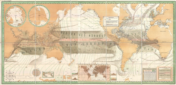
Zu Dr. Jileks Oceanografie.
sold
- Digital Map Information
- Suitable for large format printing
- File Size: 19.81 MB
- File Type: ZIP / TIFF
- ICC color profile embedded
- Delivered instantly via download link
An unusual find, this is a remarkable c. 1880 chromolithograph map of the world on a Mercator Projection illustrating ocean currents. Centered on the Pacific basin, the map covers the entire world, overlapping somewhat in Africa. While there is ... (more details)
Rare original Panoramic View of Princeton University by artist Richard Rummell.

Princeton University.
sold
- Digital Map Information
- Suitable for large format printing
- File Size: 10.78 MB
- File Type: ZIP / TIFF
- ICC color profile embedded
- Delivered instantly via download link
This is a scarce 1906 photogravure Richard Rummell view of Princeton University. Overlooking campus from a point high above today's Rockefeller College and Nassau Street, Alexander Hall and the Maclean House appear immediately on the left. On the right, the first recognizable buildings are Blair and Buyers Halls and the Blair Arch. The old Halstead Observatory appears in front of Blair Hall, which is where Joline Hall stands today. Witherspoon Hall appears immediately behind the Blair Arch in this view. Edwards Hall is partially blocked by Witherspoon Hall and Edwards does the same thing to Dod Hall. Both Little Hall and the Dillon Gym appear to the right of Edwards and Dod, and Princeton's railroad station adorns the right border with several horse-drawn carriages waiting for passengers. Returning to Alexander Hall at the center, Stanhope Hall is blocked by trees and Nassau Hall with its iconic belfry. East Payne Hall and Chancellor Green, then Princeton's library, are to the left of Nassau Hall. Dodge Hall appears to the right of East Payne Hall and McCosh Hall is illustrated to the left and behind both Didge Hall and East Payne Hall. 1879 Hall is recognizable in the background on the left. (more details)
Highly decorative early map of the Great Lakes showing fictional islands in Lake Superior.
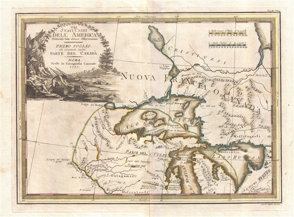
Gli Stati Uniti dell' America delineati sulle ultime Osservazioni. Primo Foglio che comprende inoltre Parte del Canada.
sold
- Digital Map Information
- Suitable for large format printing
- DPI: 300
- File Size: 7.67 MB
- File Type: ZIP / TIFF
- ICC color profile embedded
- Delivered instantly via download link
A spectacular 1797 Giovanni Maria Cassini old color map of the Western Great Lakes and the surrounding regions. Centered on Lake Superior, the map covers from the Mississippi River to the eastern limits of Lake Huron and from an apocryphal lake, ... (more details)
Very rare Iraqi issued map of Iraq with pictorial elements.
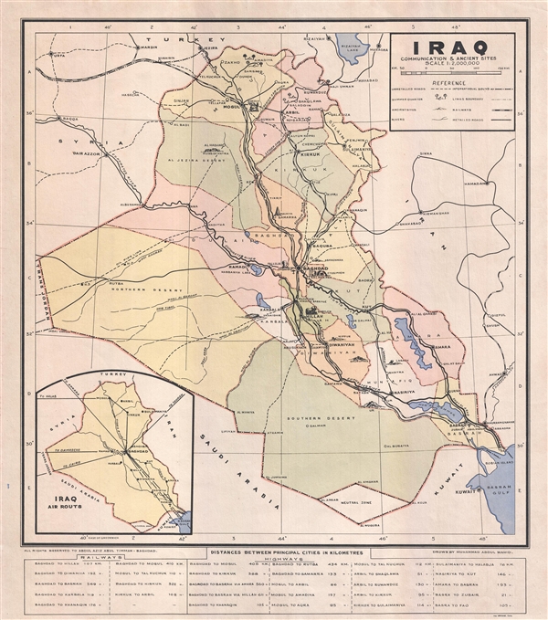
Iraq Communication and Ancient Sites.
sold
- Digital Map Information
- Suitable for large format printing
- File Size: 8.24 MB
- File Type: ZIP / TIFF
- ICC color profile embedded
- Delivered instantly via download link
A very rare c. 1940 separately issued broadside map of Iraq. The map covers all of Iraq with an emphasis on historical sites, which are rendered in profile, commination lines, and oil pipelines. The map is undated but we have been able to ... (more details)
Pre-War Map of Shanghai illustrating the situation in the city between the first and second phases of the Battle of Shanghai.

上海戰局全圖 / Shanghai Full War Map. / Shànghǎi zhànjú quán tú.
sold
- Digital Map Information
- Suitable for large format printing
- File Size: 8.53 MB
- File Type: ZIP / TIFF
- ICC color profile embedded
- Delivered instantly via download link
A scarce pre-World War II map of Shanghai, China, issued by the Osaka Asahi Shimbun in 1937 or Showa 12, issued during the Battle of Shanghai (August 13, 1937). Centered on the riverfront Bund Distract, this map covers the heart of modern ... (more details)
Arresting decorative pictorial map illustrating the fire companies of Philadelphia.
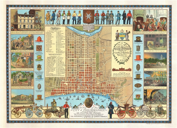
A Map of the City of Philadelphia Showing the Location of the Volunteer Fire Companies with Pictures of Some of their Engines and Equipment, Prior to, and Contemporaneous with, the Founding of the Insurance Company of North America.
sold
- Digital Map Information
- Suitable for large format printing
- File Size: 27.53 MB
- File Type: ZIP / TIFF
- ICC color profile embedded
- Delivered instantly via download link
An impressive first edition 1938 pictorial map of the city of Philadelphia illustrating that city's historic volunteer fire departments. Based upon a 1937 drawing by Jacob Riegel, the map focuses on the downtown area of modern Philadelphia ... (more details)
Highly decorative 18th century map of Brazil.
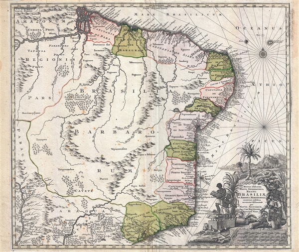
Recens elaborata mappa geographica regni Brasiliae in America Meridionali maxime celebris…
sold
- Digital Map Information
- Suitable for large format printing
- Full resolution TIFF file
- ICC color profile embedded
- Delivered instantly via download link
A very attractive 1730 map of Brazil by the Augsburg cartographer Matthaeus Seutter. The map covers Brazil from the mouth of the Amazon River to the city of São Paulo and from the Paraguay River to the Atlantic seaboard. In addition to ... (more details)
Scarce late edition of Ernest Dudley Chase's iconic map of Cape Cod showing the Kennedy Compound.
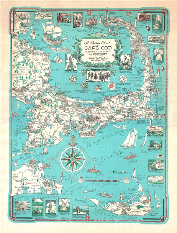
Picture Chart of Cape Cod, Martha's Vineyard and Nantucket.
sold
- Digital Map Information
- Suitable for large format printing
- File Size: 6.49 MB
- File Type: ZIP / TIFF
- ICC color profile embedded
- Delivered instantly via download link
This is a c. 1960 revision of Ernest Dudley Chase's iconic map of Cape Cod, Martha's Vineyard, and Nantucket. The map covers from Marshfield to Nantucket and from Martha's Vineyard to Provincetown. It includes the additional historic towns of Duxbury, Kingston, Plymouth, Falmouth, Hyannis, Chatham, Wellfleet, Nantucket, and Edgartown, among many others. Historical sites are rendered in profile. Surrounding the map there are countless vignettes, most of which are annotated with descriptive text, some quite humorous. President Kennedy's Summer Home is in evidence near Hyannis Port – a revision that appeared c. 1960 after Kennedy was elected. (more details)
Delightful whimsical map of New Bedford.
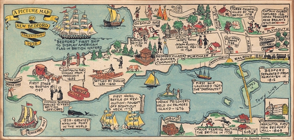
A Picture Map of New Bedford Tercentenary 1930.
sold
- Digital Map Information
- Suitable for large format printing
- File Size: 2.19 MB
- File Type: ZIP / TIFF
- ICC color profile embedded
- Delivered instantly via download link
A charming 1930 pictorial map of New Bedford, Massachusetts designed by Reynolds Printing for the 1930 Tercentenary. Oriented to the east, this map cover from Clarks Clove to Nobscot and as far inland as Pope's Island and the Fairhaven ... (more details)
Highly decorative wall sized map of Italy.
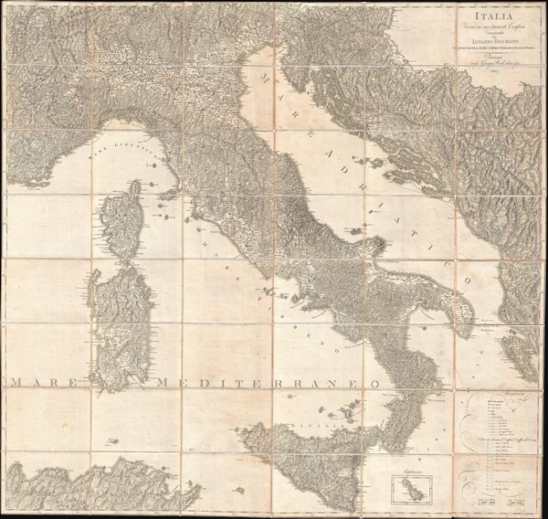
Italia Divisa ne' suoi Presenti Confini.
sold
- Digital Map Information
- Suitable for large format printing
- DPI: 300
- File Size: 52.74 MB
- File Type: ZIP / TIFF
- ICC color profile embedded
- Delivered instantly via download link
A beautifully engraved 1815 large format postal map of Italy by the Austrian cartographer Ignaz Heymann. This remarkable map covers from Lake Geneva to Sicily and from Toulon to Corfu, covering in the process all of Italy, Sardinia, ... (more details)
Charming Japanese pictorial map of the world with illustrations of cannibalism.

家庭教育世界一周すごろく / Home Education Round-the-World Sugoroku./ Katei kyōiku sekai isshū sugoroku.
sold
- Digital Map Information
- Suitable for large format printing
- File Size: 35.75 MB
- File Type: ZIP / TIFF
- ICC color profile embedded
- Delivered instantly via download link
This is an exceptionally charming Taisho 15 or 1926 Japanese pictorial world map and round-the-world sugoroku game. Although somewhat distorted and not drawn to scale, this is both a game board and a map of the world. Oriented ... (more details)
Rare propaganda broadside illustrating the Second Italo-Abyssinian War.
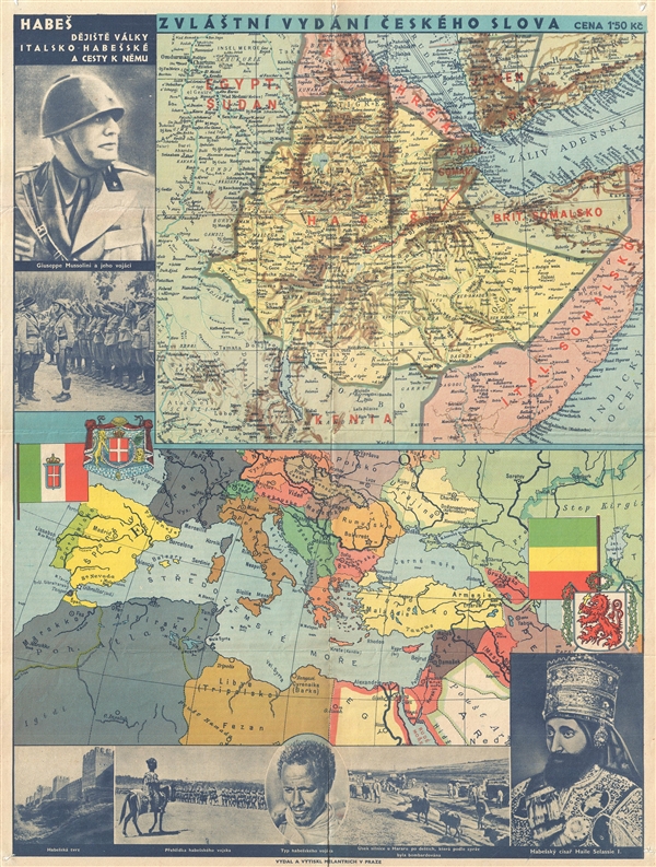
Zvláštní vydání Českého slova / Habeš dějiště války Italsko-Habešské a cesty k němu. / Special Edition of the Czech Word. Abyssina: The Theater of War in Italo-Abyssinia and the Way There.
sold
- Digital Map Information
- Suitable for large format printing
- File Size: 17.54 MB
- File Type: ZIP / TIFF
- ICC color profile embedded
- Delivered instantly via download link
An unusual 1935 Czech issue pictorial map illustrating the theater of the Second Italo-Abyssinian War (1935-1936). This informational map appears in two parts, the upper part offers a detailed map of what is essentially Modern ... (more details)
Uncommon Austrian issue map of Arabia and Persia.

Persien und Arabien nach der neuesten Begränzung, und den besten Hülfsmitteln verfasst.
sold
- Digital Map Information
- Suitable for large format printing
- DPI: 300
- File Size: 7.06 MB
- File Type: ZIP / TIFF
- ICC color profile embedded
- Delivered instantly via download link
A very attractive Austrian issued c. 1818 map of Persia and Arabia by Tranquillo Mollo. Centered on the Persian Gulf, the map covers from the Nile Valley to India and from the Caspian Sea to the Straits of Bab-el-Mandeb. It ... (more details)
Wonderful early decorative map showing both Korea and Japan in full.
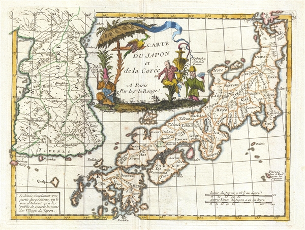
Carte du Japon et de la Corée.
sold
- Digital Map Information
- Suitable for large format printing
- DPI: 300
- File Size: 2.82 MB
- File Type: ZIP / TIFF
- ICC color profile embedded
- Delivered instantly via download link
An attractive 1748 map of Korea and Japan dawn by George Louis Le Rouge. The map covers both Korea and Japan in full and features a large central cartouche occupying the 'Sea of Korea' / 'Sea of Japan' region, although ... (more details)
Identifies the Sea of Korea.
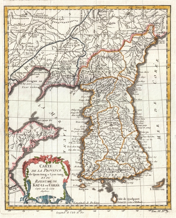
Carte de la Province de Quan-tong, ou Lyau-tong et du Royaume de Kau-li ou Coree .
sold
- Digital Map Information
- Suitable for large format printing
- DPI: 300
- File Size: 2.45 MB
- File Type: ZIP / TIFF
- ICC color profile embedded
- Delivered instantly via download link
This is an uncommon 1749 map of Korea by Jacques Nicholas Bellin. Centered on the west coast of Korea (Corea), this map covers all of peninsular Korea as well as adjacent parts of Manchuria and China. Korea, as ... (more details)
Beautiful bird's eye-view of Acapulco Mexico.

Portus Acapulco.
sold
- Digital Map Information
- Suitable for large format printing
- DPI: 300
- File Size: 5.48 MB
- File Type: ZIP / TIFF
- ICC color profile embedded
- Delivered instantly via download link
A rare 1671 view of the port of Acapulco, Mexico, by Englishman John Ogilby. This impressive view embraces the heart of colonial Acapulco, showing the Fort of San Diego and the surrounding port community. In ... (more details)