
Mind-bending Map of the Ocean Floors and Tectonic Plates.

The Ocean Floor.
sold
This is Earl C. Bateman III's visually stunning 1985 large-format map of the topography of the world's ocean floor, published by Celestial Arts. (more details)
'...And for the support of this Declaration, with a firm reliance on the protection of divine Providence, we mutually pledge to each other our Lives, our Fortunes and our sacred Honor.'
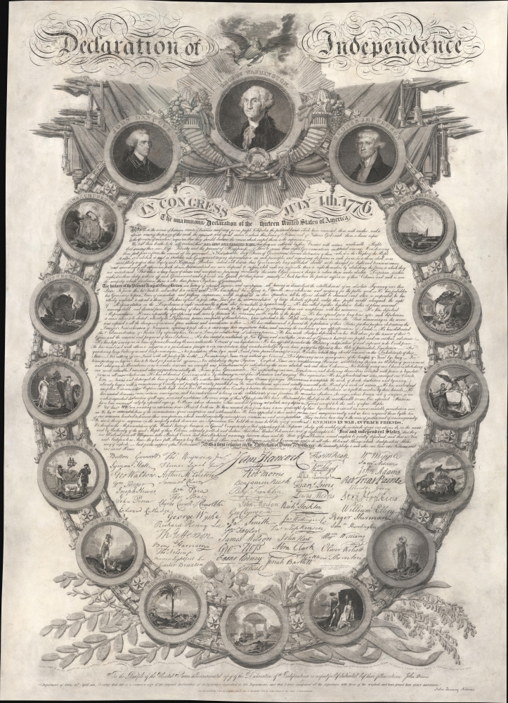
In Congress July 4th. 1776. The Unanimous Declaration of the thirteen United States of America.
sold
- Digital Map Information
- Suitable for large format printing
- DPI: 600
- File Size: 1123.34 MB
- File Type: ZIP / TIFF
- ICC color profile embedded
- Delivered instantly via download link
This is the remarkable 1819 John Binns ceremonial engraving of the Declaration of Independence. It is the most decorative of the three competing presentation broadsides of the Declaration issued between 1818 and 1823. (more details)
Birth of American Meteorology.
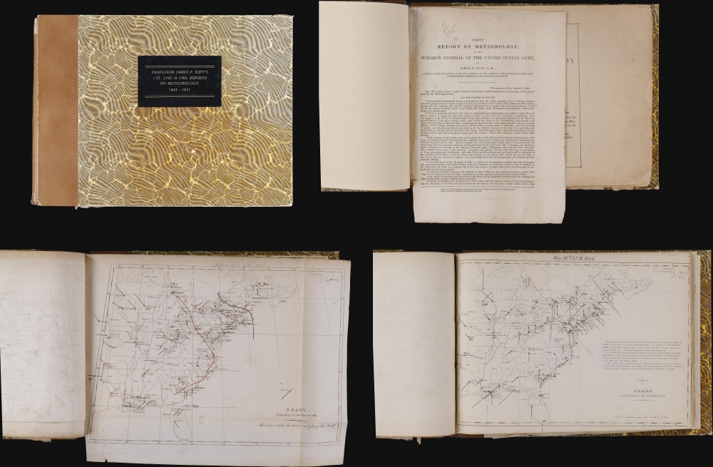
Professor James P. Espy's 1st. 2nd. and 3rd. Reports on Meteorology. 1843 - 1851.
sold
This is a bound volume containing the first (1843), second (1851), and third (1851) James Pollard Espy reports on United States meteorology. A feat of infographic mapping, the reports contain some 130 maps detailing near-weekly weather patterns. Collectively, they represent the origins of American meteorology. (more details)
'The First Ever Bilingual Map of its Kind' -Ng / Useful For Tracking Pirates. - China Mail
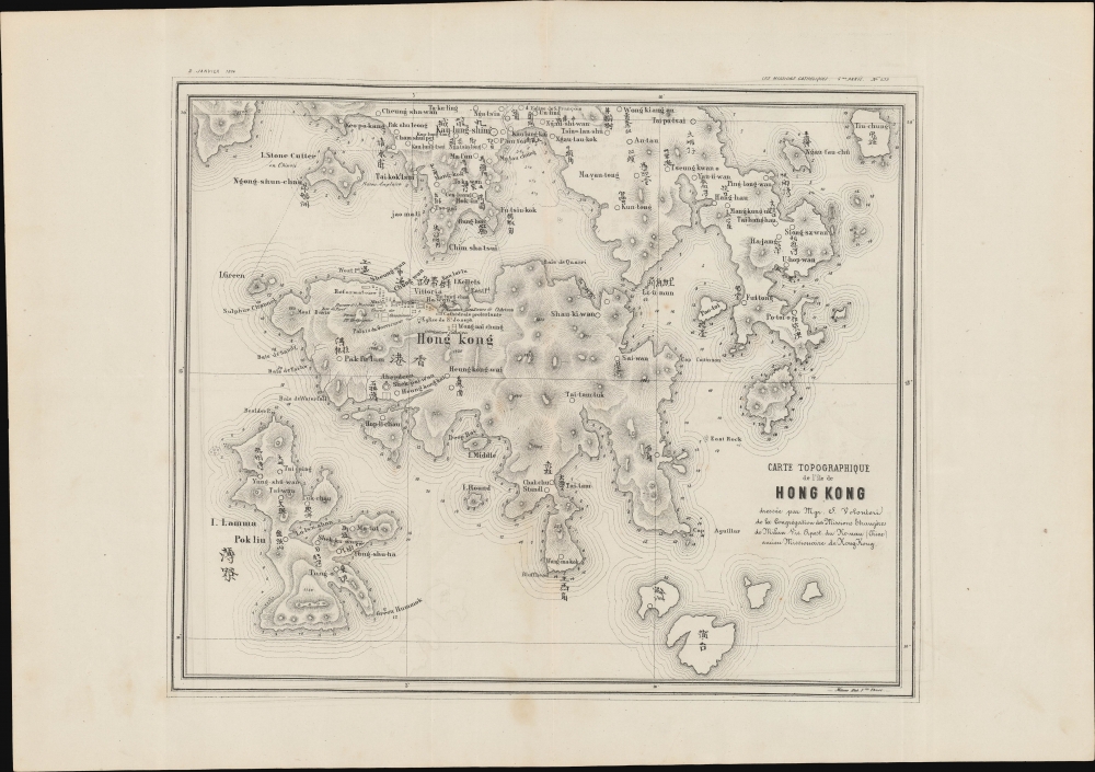
Carte Topographique de l'ile de Hong Kong dressee par Mgr. S. Volonteri de la Congregation des Missions Etrangeres de Milan Vic. Apoost du Ho-non (Chine) ancien Missionaire de Hong-Kong.
sold
- Digital Map Information
- Suitable for large format printing
- File Size: 240.71 MB
- File Type: ZIP / TIFF
- ICC color profile embedded
- Delivered instantly via download link
This is Simeone Volonteri's 1874 map of Hong Kong, the first map to offer detailed bi-lingual content specifically of Hong Kong. It is the second and lesser known of Volonteri's two maps, the first being his unobtainable 1866 Map of the San-On District (Guangdong Province). Although derived from the 1866 map, the present publication offers a significantly updated specific look at Hong Kong, with many more place names, among them the 'Eglise de S. Francois' and the 'Prison Anglais' (west of Kowloon). It served as the primary geographical reference for Hong Kong until the official surveys of 1901. (more details)
First printed map of Bombay.

[Bombay].
sold
- Digital Map Information
- Suitable for large format printing
- DPI: 600
- File Size: 8.85 MB
- File Type: ZIP / TIFF
- ICC color profile embedded
- Delivered instantly via download link
This is the rare c. 1673 John Fryer map of Mumbai, India, considered the first published map of Bombay. Fryer's map of Bombay has been criticized as 'incomplete and inaccurate,' but it nonetheless served as the basis of all subsequent maps of Bombay until the William Nicholson surveys of 1768. (more details)
A Marine's preparation for Iwo Jima.

[Iwo Jima]. / 4th Marine Division Landing Information Sheet.
sold
- Digital Map Information
- Suitable for large format printing
- Full resolution TIFF file
- ICC color profile embedded
- Delivered instantly via download link
This is a 1945 Marine Corps D-2 (Intelligence) Section map of Iwo Jima. It was created for the amphibious invasion of February 19, 1945, one of the most arduous battles in American military history. The piece offers insight into the pre-planning of the invasion. Additional manuscript content added after the battle offers a unique record of the Marine experience before, during, and after the event. (more details)
The English Confront Spain.

A New and Accurate Map of Mexico or New Spain together with California, New Mexico etc. Drawn from the best Modern Maps and Charts and Regulated by Astronl. Obsrvrn. By Eman: Bowen.
$1,200.00
Acquire
- Digital Map Information
- Suitable for large format printing
- File Size: 17.14 MB
- File Type: ZIP / TIFF
- ICC color profile embedded
- Delivered instantly via download link
This is Emmanuel Bowen's c. 1747 map of Mexico and the southern part of what would become the United States, an area at this time contested between Spain and England. The whole is rife with interesting anti-Spanish propaganda. (more details)
San Francisco in an Era of Change.

Candid San Francisco Magnificent City by the Golden Gate.
$1,200.00
Acquire
This is Richard S. Dement's scarce 1971 large-format bird's-eye pictorial view of San Francisco, California. (more details)
Planning Pacific Grove.
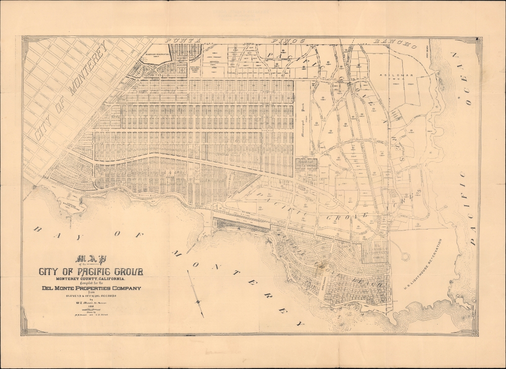
Map of the City of Pacific Grove Monterey County California compiled for the Del Monte Properties Company.
$1,100.00
Acquire
- Digital Map Information
- Suitable for large format printing
- Full resolution TIFF file
- ICC color profile embedded
- Delivered instantly via download link
This is W. T. Moore's c. 1919 map of Pacific Grove, California, produced for the Del Monte Properties Company, a major player in the development of Pacific Grove, Pebble Beach, and surrounding communities. The map marks a transitional moment for Pacific Grove and is contemporaneous with the 1919 property auction that led to the city's rapid expansion. (more details)
Godzilla. Enough said.

Nautical Chart of the Sea of Japan.
sold
A signed modern cartographic masterpiece, this is artist Anthony Petrie's 2016 map of Japan overlaid with the image of Godzilla. The map covers all of Japan. Adjacent lands that would presumably represent China or Korea, are fictional. Shading, which on most modern ... (more details)
Evolution of Harvard Yard and Harvard Square.
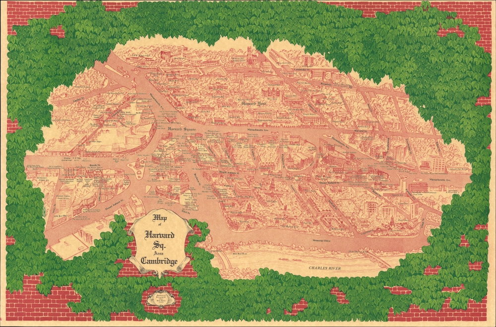
Map of Harvard Sq. Area Cambridge
sold
This is Blaise Domino's large-format 1978 pictorial bird's-eye view of Harvard Square and environs in Cambridge, Massachusetts, including Harvard Yard and much of the campus of Harvard University. (more details)
Esoteric Occult Astrology.

Cosmic Symbolism.
sold
- Digital Map Information
- Suitable for large format printing
- File Size: 22.77 MB
- File Type: ZIP / TIFF
- ICC color profile embedded
- Delivered instantly via download link
This is a scarce c. 1944 Theosophical astrological chart produced by the School of Ancient Philosophy in San Francisco, based on the thought of English Theosophist philosopher and astrologer 'Sepharial'. (more details)
Italian wine!

Vini d'Italia.
sold
This is a 1976 Yanez Oski pictorial wine map of Italy. The map celebrates Italy's rich viticultural tradition. (more details)
Rosicrucian Vision of Knowledge, God, and the Universe.

Integrae Naturae Speculum, Artisque Imago.
sold
- Digital Map Information
- Suitable for large format printing
- Full resolution TIFF file
- ICC color profile embedded
- Delivered instantly via download link
This is a rare 1617 Rosicrucian hierarchical diagram organizing the divine, cosmic, natural, and human experience into a structured, symbolic system. It was designed by the English Rosicrucian and alchemist Robert Fludd, who sought to condense the hermetic, Neoplatonic, and alchemical worldviews into a coherent vision of reality. Although rooted in Rennaissance thought, this image offers an enduring visual metaphor for the search for meaning, reflecting the impulse to systematically rationalize human experience. (more details)
Rebuilding the Kanto - a groundbreaking survey.

東京及横濱地質調查報告附圖 / [Attached Maps of the Report of the Tokyo-Yokohama Geological Survey].
sold
This is a rare complete set of sixteen maps issued in 1929 by the Geological Survey of Japan for the Bureau of Reconstruction, the Japanese government body tasked with rebuilding Tokyo and Yokohama in the wake of the Great Kanto Earthquake. The maps represent a landmark study of the geology of the Kanto region following one of the greatest natural disasters in recorded history. (more details)
Updating the Evans Map: First Map with Louisville
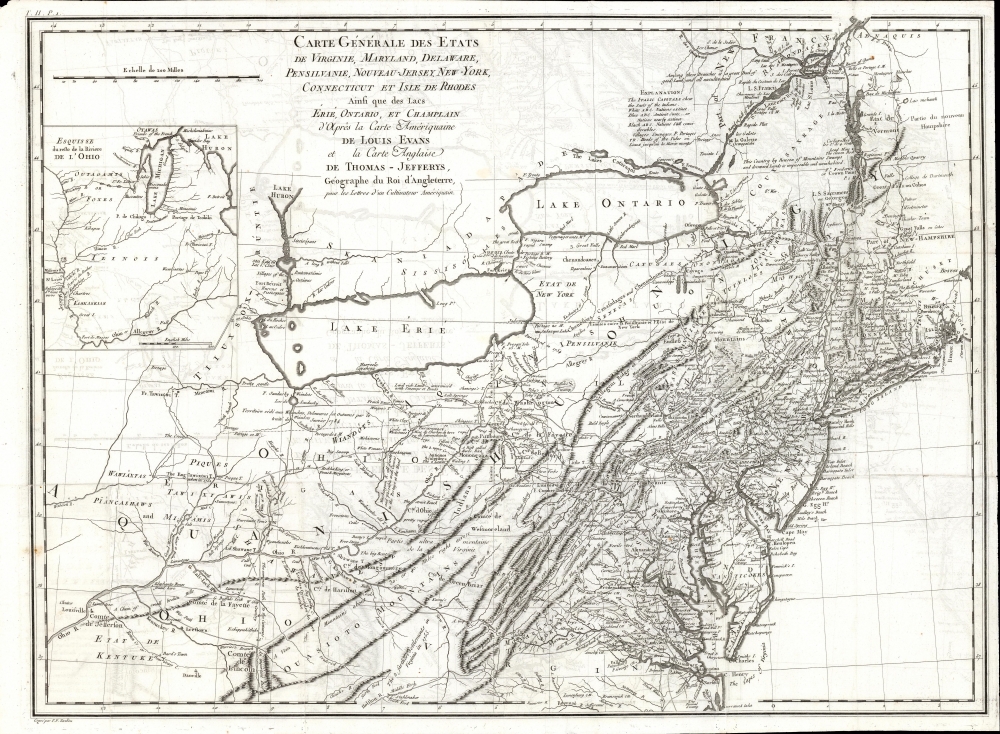
Carte Generale des Etats de Virginie, Maryland, Delaware, Pensilvanie, Nouveau-Jersey, New-York, Connecticut et Isle de Rhodes Ainsi que des Lacs Erie, Ontario, et Champlain. D'Apres la Carte Ameriquaine de Louis Evans et la Carte Anglaise de Thomas-Jefferys, pour les Lettres d'un Cultivateur Amériquain.
$1,950.00
Acquire
- Digital Map Information
- Suitable for large format printing
- DPI: 600
- File Size: 68.46 MB
- File Type: ZIP / TIFF
- ICC color profile embedded
- Delivered instantly via download link
An elegant 1787 French edition of Louis Evans' seminal and influential map of the Middle British Colonies, one of the most important maps of the British colonies and the best colonial mapping of the Ohio River Valley. It was issued for Michel Guillaume St. Jean de Crevecoeur's 1787 Lettres d'un Cultivateur Ameriquain, one of the most influential works on colonial America. (more details)
The Spanish Main with the Grace Line!

Father Neptune presenteth ye Grace Line fleet to ye olde Spanish Main.
sold
- Digital Map Information
- Suitable for large format printing
- File Size: 59.66 MB
- File Type: ZIP / TIFF
- ICC color profile embedded
- Delivered instantly via download link
This is a rare 1933 Jo Mora pictorial map of Central America commissioned by the Grace Line to celebrate and advertise its newly-launched passenger service from New York City to Seattle via the Panama Canal. (more details)
One of Colton's most beautiful maps.

Map of The Country Thirty Three Miles Around The City of New York.
sold
- Digital Map Information
- Suitable for large format printing
- Full resolution TIFF file
- ICC color profile embedded
- Delivered instantly via download link
This is the 1864 edition of one of the most beautiful pocket maps of New York made in the 19th century: Colton's Thirty Three Miles Around the City of New York. (more details)
'...radically and permanently altered western cartography.' - Wheat

Map of an Exploring Expedition to the Rocky Mountains in the Year 1842 and to Oregon and North California in the Years 1843-44.
sold
- Digital Map Information
- Suitable for large format printing
- File Size: 56.14 MB
- File Type: ZIP / TIFF
- ICC color profile embedded
- Delivered instantly via download link
This is a seminal 1845 map of the American West by Carl Preuss and John C. Frémont charting the vast region between the Missouri River and the Pacific Ocean. Based on Frémont's 1843-44 Second Expedition, this map played a pivotal role in shaping westward expansion, guiding emigrants along the Oregon Trail and California Trail, and influencing cartography for decades. Wheat hailed this map as 'radically and permanently altering western cartography.' Featuring the first accurate mapping of the Great Salt Lake, detailed topographical features, and overland migration routes, this was the most comprehensive map of the American West. (more details)
Gilded Age's Great Western Metropolis.

Faust's Map of City and County of San Francisco California.
$1,200.00
Acquire
- Digital Map Information
- Suitable for large format printing
- File Size: 52.3 MB
- File Type: ZIP / TIFF
- ICC color profile embedded
- Delivered instantly via download link
This is Henry W. Faust's 1892 map of San Francisco, California, demonstrating the growth and planned future expansion of America's western metropolis. (more details)