
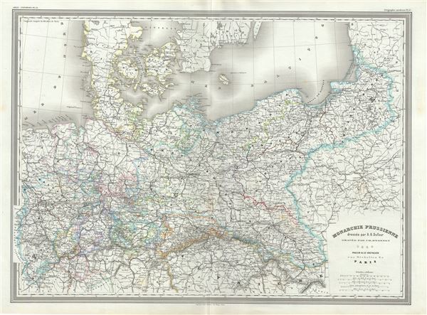
Monarchie Prussienne.
sold
- Digital Map Information
- Suitable for large format printing
- Full resolution TIFF file
- ICC color profile embedded
- Delivered instantly via download link
This is a scarce 1860 elephant folio map of Prussia by A. H. Dufour. It extends from the border of Holland eastward as far as Lithuania and south as far as Austria and Bohemia (modern day Czech Republic). Throughout, the map identifies various cities, towns, ... (more details)

Suisse et Nord de l'Italie.
sold
- Digital Map Information
- Suitable for large format printing
- Full resolution TIFF file
- ICC color profile embedded
- Delivered instantly via download link
This is an uncommon 1861 elephant folio map of Switzerland and northern Italy by A. H. Dufour. It depicts Switzerland in its entirety as well as the northern part of Italy including the territories of Piedmont and Lombardy. Throughout, the map identifies ... (more details)

Italie.
sold
- Digital Map Information
- Suitable for large format printing
- Full resolution TIFF file
- ICC color profile embedded
- Delivered instantly via download link
This is a beautiful 1860 elephant folio map of Italy by A. H. Dufour. It depicts the Italian peninsula in the midst of its struggle for national solidarity. Includes the Kingdom of Sardinia, Corsica, and Sicily. Throughout, the map identifies various ... (more details)
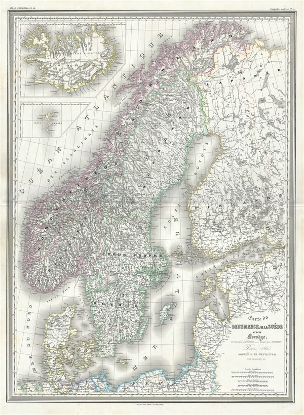
Carte du Danemarck, de la Suede et de la Norvege.
sold
- Digital Map Information
- Suitable for large format printing
- Full resolution TIFF file
- ICC color profile embedded
- Delivered instantly via download link
This is A. H. Dufour's 1860 elephant folio map of Scandinavia, including Denmark, Sweden and Norway. It covers from the Arctic south to Holstein and east as far as St. Petersburg. Two insets in the top right quadrant detail Iceland and the Faroe ... (more details)

Russie Occidentale.
sold
- Digital Map Information
- Suitable for large format printing
- Full resolution TIFF file
- ICC color profile embedded
- Delivered instantly via download link
This is a scarce large format 1860 elephant folio map of the western or European portions of Russia by A. H. Dufour. It extends from Poland east as far as the Sea of Azov and from the Gulf of Bothnia south to the Black Sea. The modern day ... (more details)

Turkquie d'Europe.
sold
- Digital Map Information
- Suitable for large format printing
- Full resolution TIFF file
- ICC color profile embedded
- Delivered instantly via download link
This is a beautiful 1860 elephant folio map of Greece, the Balkans and the European part of Turkey by A. H. Dufour. It covers from Moldavia to Candia or Crete and from the Gulf of Venice to the Adriatic Sea to the Sea of Marmara. The ... (more details)
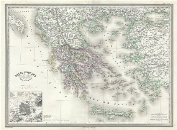
Grece Moderne.
sold
- Digital Map Information
- Suitable for large format printing
- Full resolution TIFF file
- ICC color profile embedded
- Delivered instantly via download link
This is an attractive large format 1860 elephant folio map of Greece and its colonies by A. H. Dufour. It extends from the Gulf of Taranto to the Sea of Marmara and south as far as Crete or Candia. Throughout, the map identifies ... (more details)
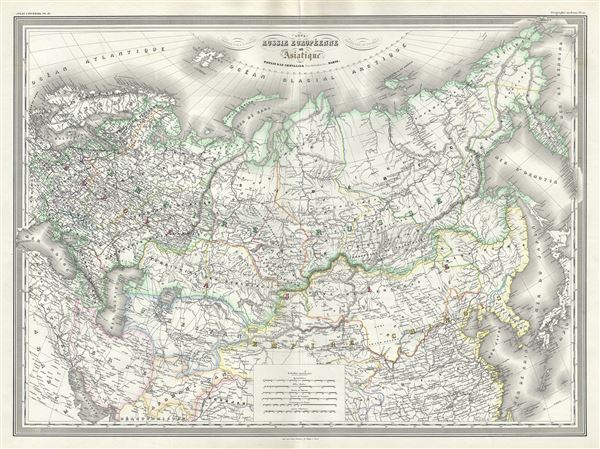
Russie Europeenne et Asiatique.
sold
- Digital Map Information
- Suitable for large format printing
- Full resolution TIFF file
- ICC color profile embedded
- Delivered instantly via download link
This is an uncommon 1860 elephant folio map of the Russian Empire by A. H. Dufour. It covers the Empire in its entirety, both in Europe and Asia, as well as parts of neighboring Tartary, Persia, Afghanistan, Chinese Empire, Japan ... (more details)
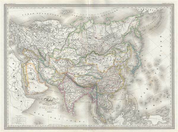
Asie.
$250.00
Acquire
- Digital Map Information
- Suitable for large format printing
- Full resolution TIFF file
- ICC color profile embedded
- Delivered instantly via download link
This is a beautiful large format 1860 elephant folio map of Asia by A. H. Dufour. It covers the entire continent from the Mediterranean to Siberia and from the Arctic to Singapore including parts of Europe and Africa. Both the ... (more details)
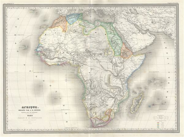
Afrique.
sold
- Digital Map Information
- Suitable for large format printing
- Full resolution TIFF file
- ICC color profile embedded
- Delivered instantly via download link
This is a large format 1860 elephant folio map of Africa by A. H. Dufour. It details the continent of Africa, including Madagascar, on the cusp of the great exploratory expeditions of the mid-19th century undertaken by Speke, ... (more details)

Amerique Du Sud.
sold
- Digital Map Information
- Suitable for large format printing
- Full resolution TIFF file
- ICC color profile embedded
- Delivered instantly via download link
This is a beautiful 1860 elephant folio map of South America by A. H. Dufour. It covers the entire continent from Panama to Tierra del Fuego. Depicts the continent in impressive detail – especially the interior, which at ... (more details)

Mexique Antilles et Californie.
sold
- Digital Map Information
- Suitable for large format printing
- Full resolution TIFF file
- ICC color profile embedded
- Delivered instantly via download link
This is a finely detailed large elephant folio 1860 map of the United States and Mexico on Mercator's projection by the French cartographer A. H. Dufour. It covers the entirety of the United States during the brief period ... (more details)

Oceanie.
sold
- Digital Map Information
- Suitable for large format printing
- Full resolution TIFF file
- ICC color profile embedded
- Delivered instantly via download link
This is an impressive 1860 elephant folio map of Australia, New Zealand, Polynesia and the Pacific Ocean by A. H. Dufour. It covers from Burma (Myanmar) east as far as Chile and from Japan south to New Zealand. Although ... (more details)
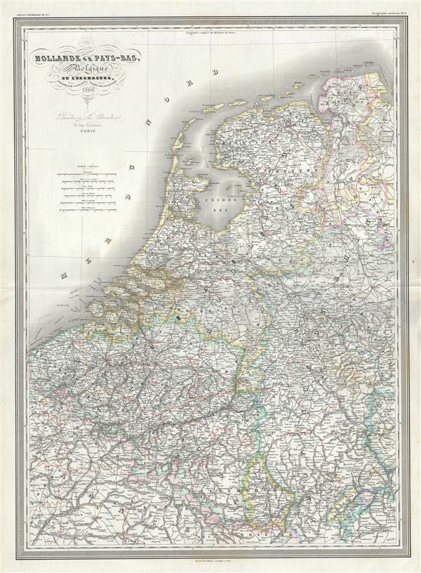
Hollande ou Pays-Bas, Belgique et Luxembourg.
sold
- Digital Map Information
- Suitable for large format printing
- Full resolution TIFF file
- ICC color profile embedded
- Delivered instantly via download link
This is a beautiful 1860 elephant folio map of Holland (The Netherlands), Belgium and Luxembourg by A. H. Dufour. It covers from Friesland to Luxembourg including parts of Germany and France. Throughout, the map ... (more details)
Remarkable map showing Alaska as an Island.
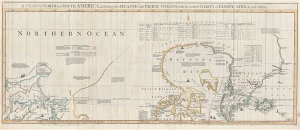
A Chart of North and South America, including the Atlantic and Pacific Oceans, with the nearest Coasts of Europe, Africa, and Asia. Chart containing part of the Icy Sea with the adjacent Coast of Asia and America. Chart comprizing Greenland with the Countries and Islands about Baffins Bay and part of Hudsons Bay.
sold
- Digital Map Information
- Suitable for large format printing
- DPI: 300
- File Size: 28.3 MB
- File Type: ZIP / TIFF
- ICC color profile embedded
- Delivered instantly via download link
A wonderful 1775 map of the Arctic regions of the Western Hemisphere by John Green or Braddock Mead. Focusing on Alaska (Bering Strait) and the Canadian Arctic, map covers from the Sea of Okhotsk (Penschinaska ... (more details)
Scarce view of Berlin.

Berlin und Colln an der Spree sampt Fridrichswerder und Dorotheen Statt. / Die Churfürstliche Brandenburgisch nun Koniglich Preussische Residenz Statt.
sold
- Digital Map Information
- Suitable for large format printing
- DPI: 300
- File Size: 6.83 MB
- File Type: ZIP / TIFF
- ICC color profile embedded
- Delivered instantly via download link
A fine 1717 map and birds-eye view of the city of Berlin by Gabriel Bodenehr. This view presented Berlin as the royal Prussian seat. When this map was made, the Kingdom of Prussia was young, having only been ... (more details)
Rare plan of Berlin.
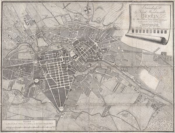
Grundriss der Königl. Residenzstädte Berlin im Jahre 1786 von neuen zusammengetragen und gestochen durch D. F. Sotzmann.
sold
- Digital Map Information
- Suitable for large format printing
- DPI: 300
- File Size: 12.15 MB
- File Type: ZIP / TIFF
- ICC color profile embedded
- Delivered instantly via download link
An extremely scarce 1786 map of Berlin, Germany by F. Nicolai and D. F. Sotzmann. This appears to be a first edition. Centered on the Spree River, this map covers central Berlin and the surrounding farmland ... (more details)
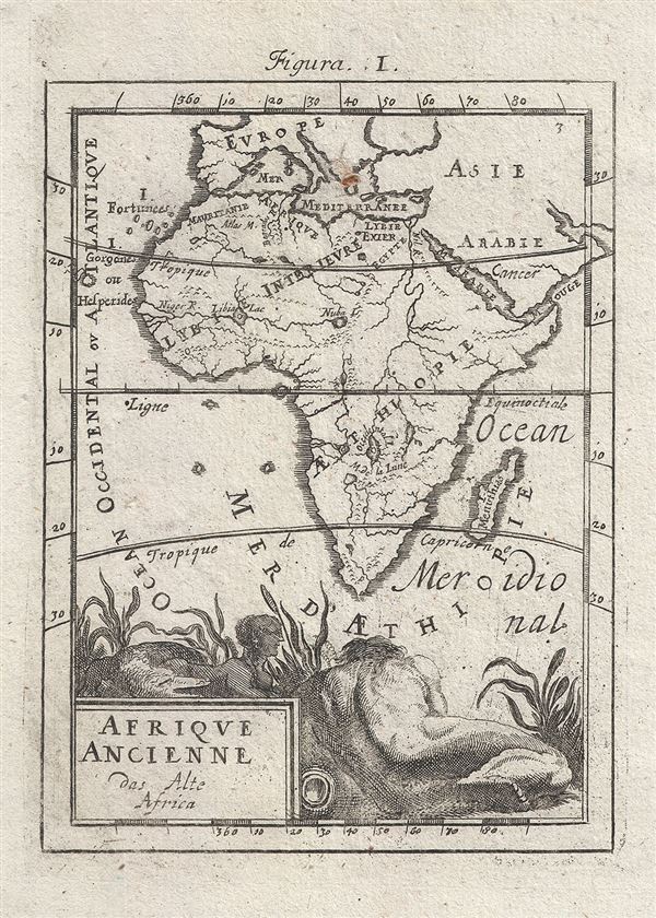
Afrique Ancienne das Alte Africa.
sold
- Digital Map Information
- Suitable for large format printing
- Full resolution TIFF file
- ICC color profile embedded
- Delivered instantly via download link
An attractive 1719 miniature map of Africa by Alain Manesson Mallet. Map covers the entire continent of Africa as well as adjacent parts of Europe, Asia, and Arabia. Attempts to illustrate Africa in ... (more details)
The first state of Vaugondy's important map of Virginia showing the lands of Lord Fairfax.
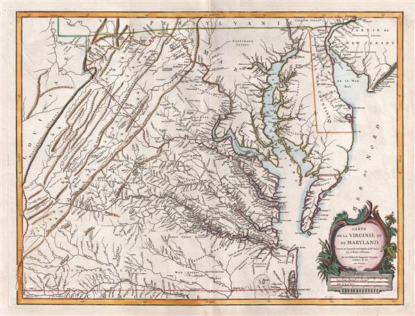
Carte de la Virginie et du Maryland.
sold
- Digital Map Information
- Suitable for large format printing
- DPI: 300
- File Size: 17.31 MB
- File Type: ZIP / TIFF
- ICC color profile embedded
- Delivered instantly via download link
A fine first edition example of Robert de Vaugondy's 1755 map of the Virginian, Delaware, and Maryland, including the Chesapeake Bay. The map extends from the Allegany Mountains eastward to the ... (more details)
One of the iconic maps of the golden age of Pictorial Maps.

A Map and History of Peiping; formerly known as Peking; capital of provinces, princedoms, and kingdoms since 1121 B.C.; in 1264 A.D. the capital of the Mongol Empire of Kublai Khan; made the capital of the Ming Empire and built as it is today by Yung Lo in 1421; continued as the capital of the Chinese Empire through the Ming and Ching Dynasties; and now a city which will live long in the memory of man as one of the greatest the world has ever known. Completed on this fifth day of February in the year of our Lord Nineteen Hundred and Thirty-six.
sold
- Digital Map Information
- Suitable for large format printing
- File Size: 39.69 MB
- File Type: ZIP / TIFF
- ICC color profile embedded
- Delivered instantly via download link
An attractive broadside example of Frank Dorn's iconic 1936 pictorial map of Beijing or Peking, China. Considered one of the great maps from the Golden Age of Pictorial Cartography, this map ... (more details)