
Bénard, Robert (sold)

Robert Bénard (1734 - c. 1785) was a French engraver. Born in Paris, Bénard is best known for supplying a significant number of plates (at least 1,800) for the Encyclopédie published by Diderot and Alembert. He also is remembered for his work with the Académie des Sciences, most notably the Descriptions des Arts et Métiers
French Edition of the First Mapping of the Society Islands
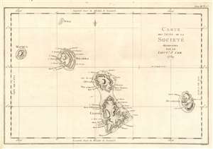
Carte des Isles de la Societé découvertes par le Lieutt. J. Cook 1769.
sold
- Digital Map Information
- Suitable for large format printing
- DPI: 600
- File Size: 10.65 MB
- File Type: ZIP / TIFF
- ICC color profile embedded
- Delivered instantly via download link
This is a 1774 map of the Society Islands - the French edition of the first map revealing the exploration of these islands by then-Lieutenant James Cook during his first Pacific voyage. Now part of French Polynesia, the map shows the islands of Maupiti (Maurua on the map), Tupai (Tubai), Bora Bora (Bolabola),Tahaa (Otaha), Raiatea (Ulieta) and Huaheine. Cook's visit was the Islands' first contact with Europeans; Cook discussed in his journal the naming of the 'Society Islands:
'So call'd by the Natives and it was not thought advisable to give them any other names but these three together with Huaheine, Tubai, and Maurua as they lay contiguous to one another I have named Society Isles .'Topography of each of the islands is shown pictorially, including reefs, mountains, and valleys. Depth soundings and anchorages are shown for Huaheine, Raiatea and Otaha. Engraved by Bernard for the 1774 French edition of John Hawkesworth's Account of the Voyages…, in which this was contained as Plate 1 in Volume III. (more details)
A Chart of Pitcairn Island as Carteret Found It
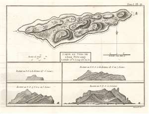
Carte et Vues de l'Isle Pitcairn.
sold
- Digital Map Information
- Suitable for large format printing
- DPI: 600
- File Size: 4.66 MB
- File Type: ZIP / TIFF
- ICC color profile embedded
- Delivered instantly via download link
This is a 1774 map of Pitcairn Island, encountered first by Europeans on Captain Carteret's circumnavigation of 1767. HMS Swallow having been separated from the other ship of the expedition and gripped with scurvy, the opportunity for resupply would have been tantalizing. It was not, however, to be:
We continued our course westward till the evening of Thursday the 2d of July when we discovered land to the northward of us. Upon approaching it the next day, it appeared like a great rock rising out of the sea: it was not more than five miles in circumference, and seemed to be uninhabited; it was, however, covered with trees, and we saw a small stream of fresh water running down one side of it. I would have landed upon it, but the surf, which at this season broke upon it with great violence, rendered it impossible.The island was first spotted by fifteen-year-old midshipman Robert Pitcairn, and so named after him. (The unfortunate middie would die at sea three years later.) As Carteret was unable to survey the island by foot, the interior topography must be construed as speculative, based on the analysis of the views of the island taken from sea. The breakers along the souther shore of the island and the rough coastline that so discouraged the explorer are discernible in the views. (more details)
Fascinating Chart Tracking Four Great Circumnavigators' Passage through the Society Islands
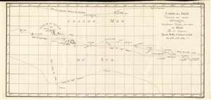
Carte Des Isles Decouvertes Aux Environs D'Otahiti, dans Plusieurs Voyages Faits Autour Du Monde Par Les Capitaines Byron, Wallis, Carteret et Cook. En 1765, 1767,1769.
sold
- Digital Map Information
- Suitable for large format printing
- DPI: 600
- File Size: 10.93 MB
- File Type: ZIP / TIFF
- ICC color profile embedded
- Delivered instantly via download link
This is a 1774 map showing the explorations of Captains Cook, Byron, Wallis and Carteret in the vicinity of Tahiti and the Society Islands from 1765 to 1769. The chart extends from the Scilly Islands in the west to Whitsunday Island in the east, and from Tepoto Island in the north to Oheiroa in the south. Each of the circumnavigators' tracks are shown as they tacked through the islands. Tahiti, Bora Bora, Otaha, Marma, Ulietea, and other islands are named and shown. These voyages represented the first recorded European contacts with many of these remote places. (more details)
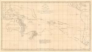
Carte d'une partie de la Mer du Sud Contenant les Découvertes des Vaisseaux de sa Majesté le Dauphin, Commodore Byron, La Tamar, Capit.ne Mouats, 1765. Le Dauphin, Capit.ne Wallis, Le Swallow, Capit.ne Carteret, 1767. et l'Endeavour, lieutenant Cook, 1769.
sold
- Digital Map Information
- Suitable for large format printing
- DPI: 600
- File Size: 20.32 MB
- File Type: ZIP / TIFF
- ICC color profile embedded
- Delivered instantly via download link
This is a 1774 map of the South Pacific Ocean, comparing the routes taken during three great circumnavigations of the 18th century: Byron and Mouat's 1763 journey aboard HMS Dolphin and Tamar; the 1767 circumnavigation of Wallis and Carteret aboard HMS Dolphin and the Swallow; and the 1769 voyage of the Endeavor under then - Lieutenant James Cook. To the East, the map shows the coasts of southern Mexico, part of the Caribbean islands, Central America and South America, including Tierra del Fuego and the Falklands. The western extremes of the map include part of China, Cochinchina, and the East Indies as far as Sumatra. Revealed in the ocean between are the late discoveries in the South Pacific, especially those of Cook, which provided the first detailed charting of Australia and New Zealand since Tasman's 1642 voyage. (more details)
Considered to be the most important map of New Zealand, it was created by Captain Cook in the 1770s and consulted into the twentieth century.
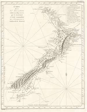
Carte de la Nle. Zelande visitée en 1769 et 1770 par le Lieutenant J. Cook Commandant de l'Endeavour vasseau de sa Majesté.
sold
- Digital Map Information
- Suitable for large format printing
- DPI: 600
- File Size: 12.72 MB
- File Type: ZIP / TIFF
- ICC color profile embedded
- Delivered instantly via download link
Recognized as the most important map in the history of New Zealand, this is the first French edition of Captain James Cook's landmark map of New Zealand. The first map to prove that New Zealand is composed of two islands, Cook's course through what is still known as Cook's Strait separating the two islands, is depicted as well. (more details)
French Edition of some of New Zealand's First European Anchorages.
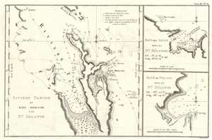
Riviere Tamise de Baye Mercure a la Nle. Zélande/ Baye des Isles dans la Nle. Zélande. / Baye de Tolaga dans la Nle. Zélande.
sold
- Digital Map Information
- Suitable for large format printing
- DPI: 600
- File Size: 8.51 MB
- File Type: ZIP / TIFF
- ICC color profile embedded
- Delivered instantly via download link
This is the 1774 first French edition of the first map of New Zealand's North Island, navigated by then-Lieutenant James Cook during his first voyage of discovery aboard the H.M.S. Endeavor. (more details)
Starting off on the wrong foot.
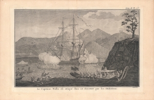
Le Capitaine Wallis est attaqué dans le Dauphin par les Otahitiens.
sold
- Digital Map Information
- Suitable for large format printing
- Full resolution TIFF file
- ICC color profile embedded
- Delivered instantly via download link
This is Robert Benard's view of the ship HMS Dolphin under attack off Tahiti, which appeared in the 1774 French translation of the book, An Account of the Voyages…, published the previous year by John Hawkesworth. Wallis was likely the first European to discover Tahiti (Spanish and Portuguese mariners might have reached it earlier) and, despite this incident, came to regard the island and those around it highly. (more details)
A French edition of Cook's map of the South Pacific Islands which he 'discovered' during his Second Voyage.
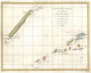
Carte des Découvertes faites dans la Mer Pacifique sur le Vaisseau de Roi, la Resolution, Commandé par the Capitaine Cook en 1774.
sold
- Digital Map Information
- Suitable for large format printing
- DPI: 600
- File Size: 12.14 MB
- File Type: ZIP / TIFF
- ICC color profile embedded
- Delivered instantly via download link
This is a 1778 Robert Bénard and James Cook map of New Caledonia and Vanuatu. Depicting the islands from the north, the map depicts New Caledonia and the Isle of Pines on the top left and several of the islands in the Vanuatu archipelago, including Espiritu Santo, on the lower right. Discovered during his second voyage, Cook called Vanuatu the New Hebrides, the name that was used until 1980 when the Republic of Vanuatu was established. Cook's route through Vanuatu and around New Caledonia is traced here and there are even references to specific dates where he and his crew landed. Both island groups had been completely unknown to Europeans before Cook's arrival in 1774, although Europeans had 'discovered' Espiritu Santo twice before. A Portuguese explorer sailing for the Spanish Crown landed on the island in 1606, and a French explorer arrived in 1768, but it was Cook's discovery and name that history remembers. (more details)
Unusual map of Bombay / Mumbai.
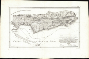
Carte d'Une Partie des Côtes de L'Inde, depuis Bombay jus'qu'a Surate, avec le détail des Habitations de cette Côte.
sold
- Digital Map Information
- Suitable for large format printing
- File Size: 11.25 MB
- File Type: ZIP / TIFF
- ICC color profile embedded
- Delivered instantly via download link
This is a 1782 Pierre-Marie-François Pàges map of Bombay, India, and its vicinity. Produced near the end of the First Anglo-Maratha War, this map is uncommon in that it details not just the British fortification on Bombay Island, but also the surrounding Gujarat countryside and communities. (more details)
Unusual map of Bombay / Mumbai.
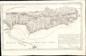
Carte d'Une Partie des Côtes de L'Inde, depuis Bombay jus'qu'a Surate, avec le détail des Habitations de cette Côte.
sold
- Digital Map Information
- Suitable for large format printing
- File Size: 8.12 MB
- File Type: ZIP / TIFF
- ICC color profile embedded
- Delivered instantly via download link
This is an unusual 1782 Pierre-Marie-François Pàges map of Bombay, India, and its vicinity. The map is uncommon in that it details not just the British fortification on Bombay Island, but also the surrounding Gujarat countryside and communities. (more details)