
Hassenstein, Bruno (sold)

Bruno Hassenstein (November 23, 1839 - August 27, 1902) was a German cartographer and was born in Ruhla, Thuringia. In 1854, Hassenstein began studying cartography and working under August Petermann in Gotha, founder of Petermanns Geographische Mitteilungen. Over the ensuing years, Hassenstein drew numerous maps for Petermanns Geographische Mitteilungen before relocating to Berlin in 1866 to work for another cartographer, including Karl Klaus von der Decken. He returned to Gotha two years later and works on maps for Henrich Theodor Menke's edition of Spurner's atlas of medieval history. He became editor of the cartography section of the Mittellungen in 1878 and worked on the Atlas von Japan, which was published in 1885. The University of Göttingen awarded him an honorary doctorate in 1878.
Map of Korea and blueprint for foreign control.
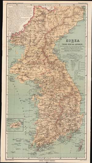
Korea oder Tscho-sen der Japaner / [Korea, or Japanese Chōsen].
sold
- Digital Map Information
- Suitable for large format printing
- File Size: 14.84 MB
- File Type: ZIP / TIFF
- ICC color profile embedded
- Delivered instantly via download link
This is an 1883 map of the eight provinces of Chosŏn Korea, partially translated into German from an English-language map, which in turn was based on a map made by the Japanese military in 1875. The convoluted history of this map shows both the curiosity about the 'hermit kingdom' and the competing imperial interests that would be at play once Korea was forcibly opened to greater foreign influence. (more details)
German map depicting the exploration of Sichuan and Yunnan Provinces in southwestern China.
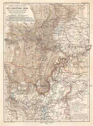
Karte Eines Theiles de Süd-Westlichen China Hauptsächlich nach neueren Forschungen in Ssu-chuen & Yün-nan
sold
- Digital Map Information
- Suitable for large format printing
- File Size: 9.94 MB
- File Type: ZIP / TIFF
- ICC color profile embedded
- Delivered instantly via download link
This is an 1883 map of Sichuan and Yunnan Provinces in southwestern China by the German cartographer Bruno Hassenstein. The map depicts most both provinces, as well as parts of Tibet and Guizhou Province. The routes taken by several expeditions are illustrated on ... (more details)
German map depicting the journeys of Nikolai Przewalski, and Qinghai Lake, the largest lake in China.
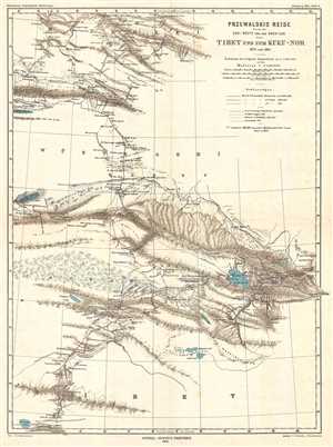
Przewalski's Reise durch die Gobi-Wüste und den Kwen-Lun nach Tibet und zum Kuku-Nor 1879 und 1880.
sold
- Digital Map Information
- Suitable for large format printing
- File Size: 5.28 MB
- File Type: ZIP / TIFF
- ICC color profile embedded
- Delivered instantly via download link
This is an 1883 German map which was published in Petermanns Geographische Mitteilungen . The map depicts the journeys of Russian explorer Nikolay Mikhaylovich Przhevalsky from Mongolia into northern Tibet and parts of western China. Three different routes taken ... (more details)
German map depicting the exploration of southwestern China including an inset city map of Lhasa.
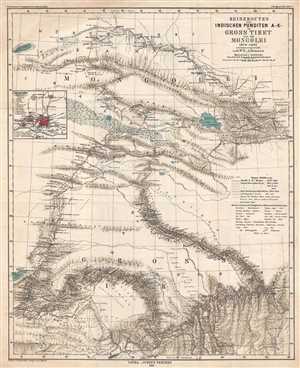
Reiserouten des Indischen Punditen A - K - in Gross Tibet und der Mongolei 1879-1882.
sold
- Digital Map Information
- Suitable for large format printing
- File Size: 9.1 MB
- File Type: ZIP / TIFF
- ICC color profile embedded
- Delivered instantly via download link
This is an 1885 map of expeditions in western China compiled by G.W.E. Atkinson. The map depicts from Mongolia through Qinghai Province to Tibet. The map illustrates several different routes takes by different explorers, including the route of three different ... (more details)
A fascinating botanical map of Guatemala.
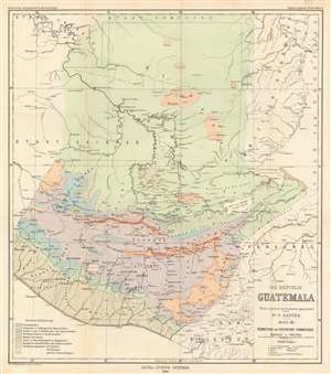
Die Republik Guatemala nach eigenen Aufnahmen gezichnet. Karte III : Verbreitung der Vegetations Formationen.
sold
- Digital Map Information
- Suitable for large format printing
- File Size: 18.59 MB
- File Type: ZIP / TIFF
- ICC color profile embedded
- Delivered instantly via download link
This is an 1894 Bruno Hassenstein vegetation map of Guatemala. Hassenstein uses colors to differentiate between zones, allowing a viewer to easily discern Guatemala's incredible botanical diversity. These colors represent ten different botanical zones, including littoral forests, tropical and subtropical rainforests, damp deciduous and coniferous forests, dry oak and pine forests, tree savannas and grass and shrub steppes and chaparrals. The final three focus on the distribution of pine trees, Taxisco (Taxixcó) trees (a tree indigenous to Guatemala), and large Cereus, a genus of cacti. Aside from this fascinating botanical content, cities and towns throughout Guatemala are identified, as are rivers and lakes. (more details)
A rare geological map of Guatemala.
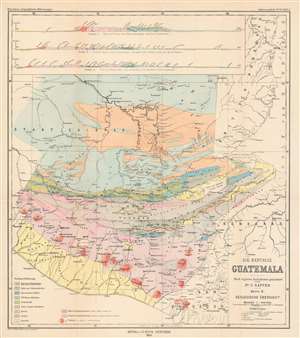
Die Republik Guatemala Nach eigene Aufnahmen gezeiehnet von Dr. C. Sapper. Karte II: Geologische Übersicht.
sold
- Digital Map Information
- Suitable for large format printing
- File Size: 20.11 MB
- File Type: ZIP / TIFF
- ICC color profile embedded
- Delivered instantly via download link
This is an 1894 Bruno Hassenstein geological map of Guatemala. Eleven different colors represent eleven different geological formations, including Azoic formations, formations of talc and chlorite slate, tertiary formations, quaternary formations, and older and younger igneous rock formations. A key situated in the lower left corner identifies which color corresponds with which formation, and small upper-case letters are used on the map to explicitly identify the color used in different sections of the map. Even small areas of each color are labeled, allowing for easy identification of the formations. Three profiles are situated along the top border and present this information from a much different perspective, allowing the viewer a better understanding of how rock formations create layers in the Earth's crust. The first profile illustrates an area 'from the coast via Huehuetenango to the Rio Usumacinta', while the second details a region 'from the coast via Guatemala, Salama and Coban to the Rio de la Pasion', and the third depicts an area from the coast over the Chilasco Plateau to La Libertad'. (more details)
A detailed map of the Rio Polochic which empties into Lake Izabel.
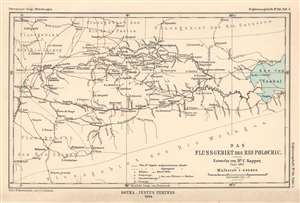
Das Flussgebiet des Rio Polochic.
sold
- Digital Map Information
- Suitable for large format printing
- File Size: 2.91 MB
- File Type: ZIP / TIFF
- ICC color profile embedded
- Delivered instantly via download link
This is an 1894 Hassenstein map of the Rio Polochic (Polochic River) in Guatemala. The map depicts the region west of Lake Izabel and details not only the Rio Polochic but most of the river system, which consists of the Rio Cajabon and numerous smaller rivers and tributaries, many of which are illustrated and labeled. Towns and villages throughout the region are also identified, and Dr. Sapper's travels through the region are traced by solid red lines. (more details)
Illustrates Guatemala's watershed.
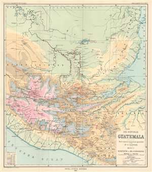
Die Republik Guatemala Nach eigenen Aufnahmen gezeichnet von Dr. C. Sapper. Karte I: Reiserouten und Oro-Hydrographie
sold
- Digital Map Information
- Suitable for large format printing
- File Size: 19.45 MB
- File Type: ZIP / TIFF
- ICC color profile embedded
- Delivered instantly via download link
This is an 1894 Hassenstein orohydrographic map of Guatemala. Orohydrography is the study of the relationship between mountains and water drainage patterns, thus an orohydrographic map illustrates a region's topography and how that topography effects its watersheds. Here, Hassenstein has employed nine different colors to highlight different areas separated by altitude, which allows the viewer to more easily understand how water would run downhill. Orohydrographic maps also illustrate flowing-water (rivers) and standing-water (lakes), in order to provide a complete understanding of the region's hydrography. Dr. Sapper's routes through the region are also traced, with the solid red line tracing overland sections and dashed lines marking parts of his journey made over water. (more details)