
Tardieu, Pierre Francois (sold)

Pierre François Tardieu (1711 - 1771) was a French engraver and mapmaker active in Paris during the middle part of the 18th century and a member of the large and prolific Tardieu family. Several members of the family established themselves as engravers, and, for over 200 years, the family produced works. Pierre Francois Tardieu was born around 1711 in Paris, son of Jean Tardieu. His uncle, Nicolas-Henry Tardieu, taught him the art of engraving. Pierre was a general engraver whose work was not limited to maps but also included historical and genre works. Many of his maps are extremely significant and include some of the finest French productions of the period. Tardieu had his office at Rue de al Corderie, Paris. Tardieu was married to Marie-Anne Rousselet (1733-1826), whose family included the engraver Gilles Rousselet and the sculptor Jean Rousselet. It is highly likely that Pierre Francois Tardieu was succeeded by Pierre Antoine Francois Tardieu (1757 - 1822), who is also possibly his son, as the latter continued to engrave under the P. F. Tardieu imprint well after the former's death.
Detailed and attractive map of Madrid, Spain.
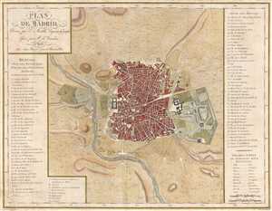
Plan de Madrid.
sold
- Digital Map Information
- Suitable for large format printing
- DPI: 300
- File Size: 6.74 MB
- File Type: ZIP / TIFF
- ICC color profile embedded
- Delivered instantly via download link
This is a 1782 Edme Mentelle map or plan of Madrid, Spain. This map depicts the city of Madrid from the Manzanares River in the west to the Campo Grande in the east and from the Puerta de Embaxadores in the south to the Puerta des los Pozos in the north as well as ... (more details)
The earliest specific map of Martha's Vineyard.
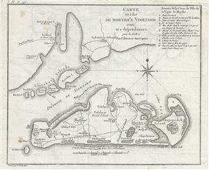
Carte de L'Ile de Martha's Vineyard avec ses dependances, pour les Lettres d'un Culuvateur Ameriquain.
sold
- Digital Map Information
- Suitable for large format printing
- DPI: 300
- File Size: 3.33 MB
- File Type: ZIP / TIFF
- ICC color profile embedded
- Delivered instantly via download link
This attractive map by P. F. Tardieu is the earliest obtainable separate map of Martha's Vineyard. It covers Martha's Vineyard in full as well as parts of the adjacent Elizabeth Islands. The map extends northwards to include, vaguely, all of Buzzards Bay and ... (more details)
An Essential Martha's Vineyard Map.
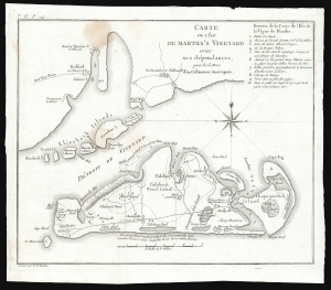
Carte de L'Ile de Martha's Vineyard avec ses dependances, pour les Lettres d'un Culuvateur Ameriquain.
sold
- Digital Map Information
- Suitable for large format printing
- File Size: 4.25 MB
- File Type: ZIP / TIFF
- ICC color profile embedded
- Delivered instantly via download link
This small but important map by P. F. Tardieu is the earliest obtainable separate map of Martha's Vineyard, Massachusetts. (more details)
The earliest obtainable specific map of Martha's Vineyard.
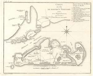
Carte de L'Ile de Martha's Vineyard avec ses dependances, pour les Lettres d'un Culuvateur Ameriquain.
sold
- Digital Map Information
- Suitable for large format printing
- DPI: 600
- File Size: 4.78 MB
- File Type: ZIP / TIFF
- ICC color profile embedded
- Delivered instantly via download link
This small but important map by P. F. Tardieu is the earliest obtainable separate map of Martha's Vineyard, Massachusetts. It covers Martha's Vineyard in full as well as parts of the adjacent Elizabeth Islands. The map extends northwards to include, vaguely, all of Buzzards Bay and southwards as far as Nomans Land Island, now a wildlife refuge. On the Vineyard, details include roads, natural features, towns and villages, and two meeting houses. Tardieu locates Edgartown, Tidsbury Wood, Tidsbury Town, Chappaquiddick (Chapoquidick), Eel Pond, Peat Swamp, Squidnoket Pastures, and Cape Pog Pond, etc. Although published in Paris for a French audience, most of the text is in English. The exception is the title and a key in the upper right identifying 10 additional numbered locations. (more details)
The earliest obtainable specific map of Nantucket.
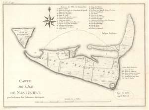
Carte de L'Ile de Nantucket, pour les Lettres d'un Culuvateur Ameriquain.
sold
- Digital Map Information
- Suitable for large format printing
- DPI: 600
- File Size: 4.67 MB
- File Type: ZIP / TIFF
- ICC color profile embedded
- Delivered instantly via download link
This small but important map by P. F. Tardieu is the earliest obtainable separate map of Nantucket Island, Massachusetts. It covers Nantucket in full as well as the adjacent island of Tuckanuck (Tuckernuck Island). Throughout some 32 locations are identified via a numeric coding system associated with tables above and to the right of the main map. Property divisions on the island are noted as well as a few important buildings, mills, and villages. (more details)
Later edition of Lewis Evans' map, considered a milestone both for its political significance and expansion of cartographic knowledge.
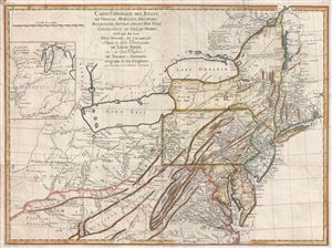
Carte Generale des Etats de Virginie, Maryland, Delaware, Pensilvanie, Nouveau-Jersey, New-York, Connecticut et Isle de Rhodes Ainsi que des Lacs Erie, Ontario, et Champlain. D'Apres la Carte Ameriquaine de Louis Evans et la Carte Anglaise de Thomas-Jefferys.
sold
- Digital Map Information
- Suitable for large format printing
- DPI: 300
- File Size: 16.54 MB
- File Type: ZIP / TIFF
- ICC color profile embedded
- Delivered instantly via download link
A scarce French edition of Louis Evans' highly influential map of the Middle British Colonies, one of the most important maps of the British Colonies to appear in the 18th century. The map covers Louisville on the Ohio River eastward as far as Narragansett ... (more details)
Later edition of Lewis Evans' map, considered a milestone both for its political significance and expansion of cartographic knowledge.

Carte Generale des Etats de Virginie, Maryland, Delaware, Pensilvanie, Nouveau-Jersey, New-York, Connecticut et Isle de Rhodes Ainsi que des Lacs Erie, Ontario, et Champlain. D'Apres la Carte Ameriquaine de Louis Evans et la Carte Anglaise de Thomas-Jefferys.
sold
- Digital Map Information
- Suitable for large format printing
- DPI: 300
- File Size: 17.66 MB
- File Type: ZIP / TIFF
- ICC color profile embedded
- Delivered instantly via download link
A fine and scarce French edition of Louis Evans' highly influential map of the Middle British Colonies, one of the most important maps of the British Colonies to appear in the 18th century. The map covers Louisville on the Ohio River eastward as far as ... (more details)
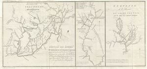
Esquisse du Muskinghum Esquisse des rivieres Muskinghum et Grand Castor.
sold
- Digital Map Information
- Suitable for large format printing
- Full resolution TIFF file
- ICC color profile embedded
- Delivered instantly via download link
This is a scarce 1787 map of the Ohio River region by Pierre Tardieu. Divided into three maps, this is one of the earliest maps of the region. The large map in the left depicts the course of the Ohio River, from the Hockhoking River and the Sandusky ... (more details)
Richly detailed map of the major tributaries of the Ohio River immediately following the American Revolution
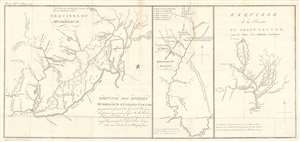
Esquisse des rivieres Muskinghum et Grand Castor que j'ai tiree du Journal du General Bouquet.
sold
- Digital Map Information
- Suitable for large format printing
- DPI: 600
- File Size: 11.19 MB
- File Type: ZIP / TIFF
- ICC color profile embedded
- Delivered instantly via download link
This is a scarce 1787 map of the Ohio River and its tributaries by Pierre Tardieu. Divided into three maps, this is one of the earliest maps of the region. The large map in the left depicts the course of the Ohio River from western Pennsylvania to the confluence of the Hockhoking River. The Sandusky River, which flows north into Lake Erie, appears at the top of the map. Its primary focus is the course of the Muskinghum River, the largest of the Ohio's tributaries in the region and the site of many indigenous and European settlements.
The center map depicts the Scioto River and its various tributaries, showing many indigenous settlements in the future location of Columbus, Ohio. The third map features the River Grand Castor - now known as the Beaver River, in Western Pennsylvania - and its tributaries. As in the other two maps, native and European settlements are noted throughout, with mountains beautifully rendered in profile. All three maps note sources for salt, trails between settlements, and native warpaths. (more details)
The center map depicts the Scioto River and its various tributaries, showing many indigenous settlements in the future location of Columbus, Ohio. The third map features the River Grand Castor - now known as the Beaver River, in Western Pennsylvania - and its tributaries. As in the other two maps, native and European settlements are noted throughout, with mountains beautifully rendered in profile. All three maps note sources for salt, trails between settlements, and native warpaths. (more details)
Detailed maps along The United States' Ohio-Pennsylvania Frontier.
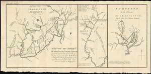
Esquisse des rivieres Muskinghum et Grand Castor que j'ai tiree du Journal du General Bouquet.
sold
- Digital Map Information
- Suitable for large format printing
- DPI: 600
- File Size: 11.03 MB
- File Type: ZIP / TIFF
- ICC color profile embedded
- Delivered instantly via download link
This is a scarce 1787 map of the Ohio River and its tributaries by Pierre Tardieu. Divided into three maps, this is one of the earliest maps of the region. The large map in the left depicts the course of the Ohio River from western Pennsylvania to the confluence of the Hockhoking River. The Sandusky River, which flows north into Lake Erie, appears at the top of the map. Its primary focus is the course of the Muskinghum River, the largest of the Ohio's tributaries in the region and the site of many indigenous and European settlements.
The center map depicts the Scioto River and its various tributaries, showing many indigenous settlements in the future location of Columbus, Ohio. The third map features the River Grand Castor - now known as the Beaver River, in Western Pennsylvania - and its tributaries. As in the other two maps, native and European settlements are noted throughout, with mountains beautifully rendered in profile. All three maps note sources for salt, trails between settlements, and native warpaths. (more details)
The center map depicts the Scioto River and its various tributaries, showing many indigenous settlements in the future location of Columbus, Ohio. The third map features the River Grand Castor - now known as the Beaver River, in Western Pennsylvania - and its tributaries. As in the other two maps, native and European settlements are noted throughout, with mountains beautifully rendered in profile. All three maps note sources for salt, trails between settlements, and native warpaths. (more details)
One French Revolution Blue Paper! Indentfies early settlements west of the Appalachian Mountains.
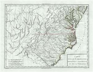
Carte de la Caroline Meridionale et Septentrionale et de la Virginie.
sold
- Digital Map Information
- Suitable for large format printing
- DPI: 300
- File Size: 9.54 MB
- File Type: ZIP / TIFF
- ICC color profile embedded
- Delivered instantly via download link
A scarce 1795 map of Virginia and Carolina by Pierre François Tardieu notable for its identification of early trade routes and settlements west of Appalachia. The map is rare and exquisitely engraved detailing the middle-southeast Atlantic seaboard covering from the Delaware Bay to the Savannah River and inland as far as modern-day Iowa. It is notably printed on high quality light blue handkerchief paper that briefly appeared during the French Revolution. (more details)
Early Italian map of the southern United States.
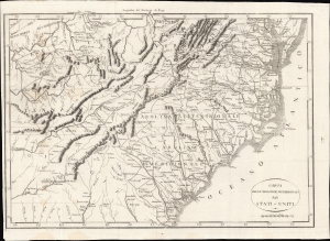
Carta Delle Provincie Meridionali degli Stati-Uniti.
sold
- Digital Map Information
- Suitable for large format printing
- Full resolution TIFF file
- ICC color profile embedded
- Delivered instantly via download link
An Italian-language map of the southern United States, very likely based on P. F. Tardieu's map of the same title in French, first published in 1801. It features rich idiosyncratic typography. The map depicts the years just after independence, when the borders of the former colonies, now states, were still forming and the white population of the area gradually moved inland. (more details)
Illustrates a South Carolina - Georgia border dispute.
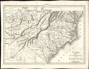
Carte De La Partie Méridionale Des Etats-Unis.
sold
- Digital Map Information
- Suitable for large format printing
- DPI: 600
- File Size: 22.63 MB
- File Type: ZIP / TIFF
- ICC color profile embedded
- Delivered instantly via download link
An important and highly detailed 1801 map of the southeastern United States by Pierre Francis Tardieu. The map was issued to a accompany Michel Guillaume de Crevecoeur's Le Voyage dans la Haute Pennsylvania et dans l'État de New-York, one of the most important post-Revolutionary War books about life and economy in the fledgling United States. Coverage extends from the Chesapeake Bay and the Ohio River south as far as central Georgia, including the modern-day states of Virginia, Kentucky, Tennessee, North Carolina, South Carolina, and parts of Georgia and Alabama. The map is notable for its exceptional detail, naming towns, mills, mines, and roads, as well as surveyed tracts intended to compensate Revolutionary War soldiers for their effort. (more details)