
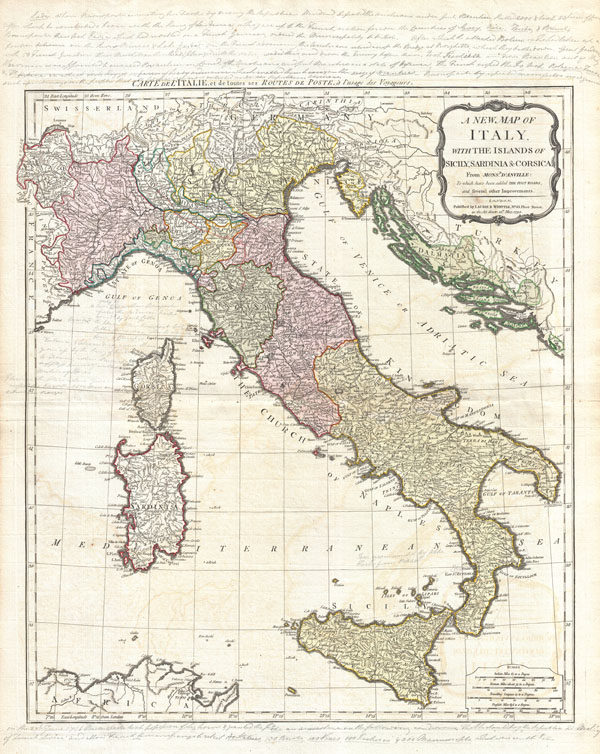
A New Map of Italy with the Islands of Sicily, Sardinia & Corsica. From Monsr. d'Anville: to which have been added the post roads and several other improvements.
sold
- Digital Map Information
- Suitable for large format printing
- DPI: 300
- File Size: 21.22 MB
- File Type: ZIP / TIFF
- ICC color profile embedded
- Delivered instantly via download link
An rare and beautiful 1794 map of Italy by J. B. B. d'Anville. Covers Italy from Switzerland south to Sicily including Corsica, Sardinia, and parts of North Africa and Dalmatia. Italy itself is divided into various states, duchies, fiefs, and kingdoms. These ... (more details)
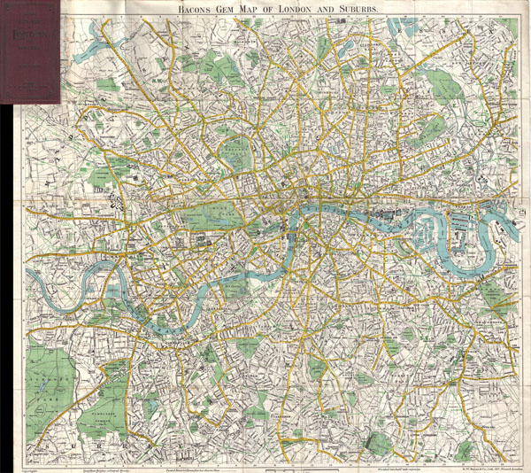
Bacons Gem Map of London and Suburbs
sold
- Digital Map Information
- Suitable for large format printing
- File Size: 21.81 MB
- File Type: ZIP / TIFF
- ICC color profile embedded
- Delivered instantly via download link
This Bacon's uncommon c. 1900 map of London, England. Covers London from Mortlake and Richmond Park to the East India Docks and Greenwich Park. Names all streets, parks, railways, and numerous important buildings. Folds into its original maroon ... (more details)
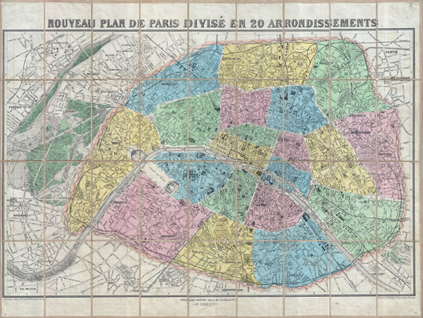
Nouveau Plan de Paris Divise en 20 Arrondissements.
sold
- Digital Map Information
- Suitable for large format printing
- File Size: 45.94 MB
- File Type: ZIP / TIFF
- ICC color profile embedded
- Delivered instantly via download link
An extremely attractive 1881 decorative pocket map of Paris in 20 arrondissements by the French publisher Theodore Lefevre. Covers the old walled city of Paris and surrounding areas including the Bois de Boulogne. Geared toward the tourist ... (more details)
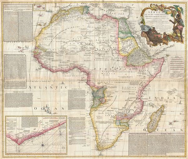
Africa, with all its States, Kingdoms, Republics, Regions, Islands, & cca. Improved and Inlarged form D’Anville’s Map to which has been added A Particular Chart of the Gold Coast wherein are Distinguished all the European Forts, and Factories by S. Boulton and also A Summary Description relative to the Trade adn Natural Produce, Manners and Customs of the African Continent and Islands.
sold
- Digital Map Information
- Suitable for large format printing
- DPI: 300
- File Size: 69.71 MB
- File Type: ZIP / TIFF
- ICC color profile embedded
- Delivered instantly via download link
This is probably the most important map of Africa produced in the 18th century. Largely based upon the earlier D'Anville map, this map has been enlarged and expanded by Samuel Boulton. Depicts the continent in full with insets of the Gold ... (more details)
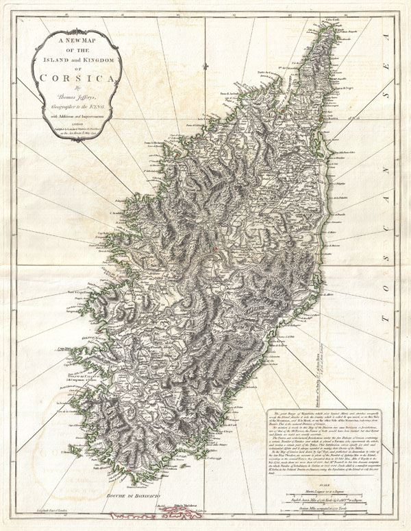
A New Map of the Island and Kingdom of Corsica.
sold
- Digital Map Information
- Suitable for large format printing
- DPI: 300
- File Size: 17.48 MB
- File Type: ZIP / TIFF
- ICC color profile embedded
- Delivered instantly via download link
An extraordinary 1794 map of the Island and Kingdom of Corsica. Covers the entire island in extraordinary detail offering both topographical and political information. With its unique blend of dramatic mountains and stunning pristine ... (more details)
An early, rarely seen, wall map of North America.
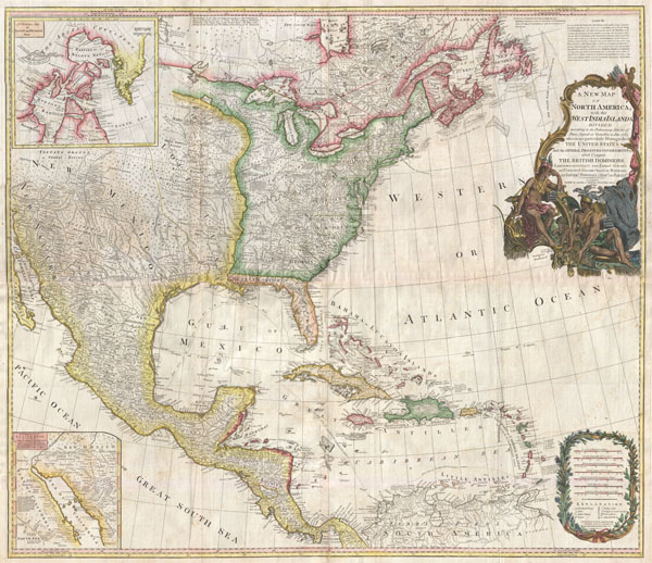
A New Map of North America with the West India Islands, divided according to the Preliminary Articles of Peace, Singed at Versailles, 20, jan 1783, wherein are particularly Distinguished The United States, and the Several Provinces, Governments & ca which Compose the British Dominions, Laid down according to the Latest Surveys, and Corrected from teh Original Materials of Goverr. Pownall, Membr. of Parlimt.
sold
- Digital Map Information
- Suitable for large format printing
- DPI: 300
- File Size: 62.52 MB
- File Type: ZIP / TIFF
- ICC color profile embedded
- Delivered instantly via download link
An extraordinary monumentally proportioned 1794 map of North American by Governor Pownell. Issued shortly after the end of the American Revolutionary War, this map details the newly formed United States, the British dominions in ... (more details)
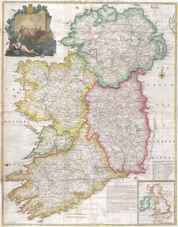
A map of the Kingdom of Ireland, divided into provinces, counties and baronies. Southern section. Shewing the archbishopricks, bishopricks, cities, boroughs, market towns, villages, barracks, mountains, lakes, bays, rivers, bridges, ferries, passes, also the great, the branch & the by post roads together with the inland navigation, by J. Rocque, Chorographer to His Majesty.
sold
- Digital Map Information
- Suitable for large format printing
- Full resolution TIFF file
- ICC color profile embedded
- Delivered instantly via download link
An absolutely stunning and monumental 1794 wall map of Ireland by Jean Rocque. Covers Ireland in full with extraordinary detail throughout. Notes every town, hamlet, bishopric, country, forest, castle swam and road. Even ... (more details)
A most impressive 18th century wall map of the world.

A General Map of the World, or Terraqueouis Globe with all the New Discoveries and Marginal Delineations, Containing the Most Interesting Particulars in the Solar, Starry and Mundane System.
sold
- Digital Map Information
- Suitable for large format printing
- DPI: 300
- File Size: 78.36 MB
- File Type: ZIP / TIFF
- ICC color profile embedded
- Delivered instantly via download link
An absolutely stunning and monumental double hemisphere wall map of the world by Samuel Dunn dating to 1794. This extraordinary map is so large and so rich in detail that it is exceptionally challenging to do it full ... (more details)
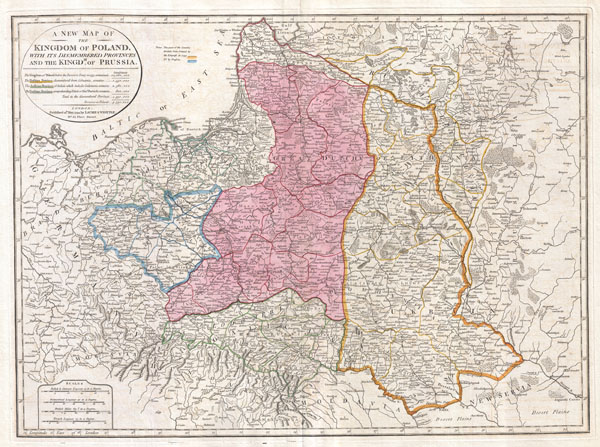
A New Map of the Kingdom of Poland, with its Dismembered Provinces and the Kingdom of Prussia.
sold
- Digital Map Information
- Suitable for large format printing
- DPI: 300
- File Size: 19.62 MB
- File Type: ZIP / TIFF
- ICC color profile embedded
- Delivered instantly via download link
This important 1794 map by Thomas Kitchin depicts the Kingdom of Poland during the brief transitional period between the second and third partitions. Covers from Brandenburg to Russia and from the Gulf of Livonia to ... (more details)

Gvinea propia, nec non Nigritae vel Terae Nigrorvm maxima pars : geographis hodiernis dicta utraq[ue] Aethiopia inferior, & hujus quidem pars australis ex delineationibus Anvillianis itineri guineensi D. de Marchais insertis secundum leges projectionis stereographicæ Hasianae designata & edita studio & labore Homannianorum Heredum. Norimb. cum privil. S.C.M. A. 1743 La Gvinee de meme que la plus grande partie du Pais des Negres : appellées par les geographes modernes Ethiopie inferievre & meridionale tirées des morceaux geographiques de Mr. d'Anville, qu'il a inseres au voyage du Chev. de Marchais, & puis desinées suivant les loix de la nouvelle projection de feu Mr. le Prof. Has, par les Heritiers d'Homan A. 1743.
sold
- Digital Map Information
- Suitable for large format printing
- Full resolution TIFF file
- ICC color profile embedded
- Delivered instantly via download link
One of the most beautifully produced maps of west Africa to appear in the 17th century. Based on earlier Homann maps and research by Anville, this map covers the northwestern part of Africa from Cape Blanc and ... (more details)

Johnson's Georgetown and the City of Washington the Capital of the United States of America.
sold
- Digital Map Information
- Suitable for large format printing
- File Size: 4.01 MB
- File Type: ZIP / TIFF
- ICC color profile embedded
- Delivered instantly via download link
A beautiful example of A. J. Johnson's 1864 map of Washington D.C. and Georgetown. Johnson's map of Washington D. C. offers a fascinating snapshot of the Union capital in the midst of the American Civil War. ... (more details)

Les Isles Britanniques Comprenant les Royaumes D'Angleterre, D'Ecosse et D'Irlande divisee en grands provinces.
sold
- Digital Map Information
- Suitable for large format printing
- DPI: 300
- File Size: 8.29 MB
- File Type: ZIP / TIFF
- ICC color profile embedded
- Delivered instantly via download link
A beautiful example of Janvier's 1771 decorative map of the British Isles. Includes all of England, Scotland and Ireland as well as parts of adjacent France, Holland and Belgium. Divided according to ... (more details)

Carte Generale de la Pologne avec tous les Etats qui en dependent.
sold
- Digital Map Information
- Suitable for large format printing
- DPI: 300
- File Size: 9.17 MB
- File Type: ZIP / TIFF
- ICC color profile embedded
- Delivered instantly via download link
A beautiful example of Rizzi-Zannoni's c. 1771 decorative map of the Poland and its tributaries. Covers from Denmark and Germany eastward to Russia, northwards to Livonia and south to Hungary. ... (more details)
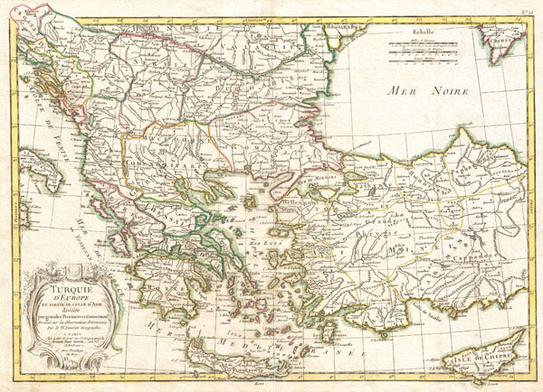
Turquie d'Europe et Partie de Celle d'Asie divisee par grandes Provinces et Gouvernemts.
sold
- Digital Map Information
- Suitable for large format printing
- DPI: 300
- File Size: 8.11 MB
- File Type: ZIP / TIFF
- ICC color profile embedded
- Delivered instantly via download link
A beautiful example of Janvier's 1771 decorative map of Turkey in Europe. Covers from Croatia and the boot of Italy eastward as far as Crimea, the Black Sea, Cappadocia, and Cyprus. Extends ... (more details)

Carte du Royaume D'Angleterre.
sold
- Digital Map Information
- Suitable for large format printing
- DPI: 300
- File Size: 3.12 MB
- File Type: ZIP / TIFF
- ICC color profile embedded
- Delivered instantly via download link
A beautiful example of Rigobert Bonne's 1771 decorative map of England and Wales. Covers all of England and Wales as well as parts of adjacent Scotland, Ireland and France. Divided by ... (more details)

Carte des Regions et des Lieux dont il est parle dans le Nouveau Testament.
sold
- Digital Map Information
- Suitable for large format printing
- DPI: 300
- File Size: 7.05 MB
- File Type: ZIP / TIFF
- ICC color profile embedded
- Delivered instantly via download link
A beautiful example of Rigobert Bonne's 1771 decorative map of the lands of the Bible's New Testament. Covers from Italy eastward to include the Eastern Mediterranean, parts of Africa, ... (more details)

Carte du Royaume D'Ecosse.
sold
- Digital Map Information
- Suitable for large format printing
- DPI: 300
- File Size: 6.41 MB
- File Type: ZIP / TIFF
- ICC color profile embedded
- Delivered instantly via download link
A beautiful example of Rigobert Bonne's 1771 decorative map of Scotland. Covers All of Scotland including the Shetland, Orkney and Hebrides Islands. Divided by county. A decorative ... (more details)

Partie Occidentale de l'Empire de Russie, Extrait de l'Atlas Russien et d'autres Cartes. Partie Orientale de l'Empire de Russie, Extrait de l'Atlas Russien et d'autres Cartes.
sold
- Digital Map Information
- Suitable for large format printing
- DPI: 300
- File Size: 17.55 MB
- File Type: ZIP / TIFF
- ICC color profile embedded
- Delivered instantly via download link
A beautiful example of Rigobert Bonne's 1771 decorative map of Russia. On two sheets, covers from the Baltic Sea to Siberia and the Bering Straits, extends south as far as the ... (more details)
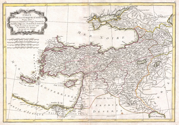
Carte de la Turquie D'Asie Presque entiere Contenant L'Anatolie, La Georgie,L'Armenie, Le Curdistan, L'Alge-zira, L'Irak-Arabi, La Syrie & c.
sold
- Digital Map Information
- Suitable for large format printing
- DPI: 300
- File Size: 7.19 MB
- File Type: ZIP / TIFF
- ICC color profile embedded
- Delivered instantly via download link
A beautiful example of Rigobert Bonne's 1771 decorative map of Turkey in Asia. Covers from Egypt north to Crimea and from Crete and the Dardanelles east to the Persian Gulf ... (more details)

Terrae Sanctae Tabula e Scripturae Sacrae, Flavii Josephi, Eusebii et Divi Heironymi …
sold
- Digital Map Information
- Suitable for large format printing
- DPI: 300
- File Size: 19.3 MB
- File Type: ZIP / TIFF
- ICC color profile embedded
- Delivered instantly via download link
A beautiful example of Guillaume and Joseph De L'Isle's 1762 decorative map of the Holy Land, including Israel and Palestine. In two sheets, covers the region from Gaza and ... (more details)