
Beautiful hand colored map of the Duchy of Lithuania divided into palatinates.

Grand Duché de Lithuanie divisé par Palatinats. Par le Sr. Robert de Vaugondy, Fils de Mr. Robert Geog. du Roi.
sold
- Digital Map Information
- Suitable for large format printing
- DPI: 300
- File Size: 2.21 MB
- File Type: ZIP / TIFF
- ICC color profile embedded
- Delivered instantly via download link
This is a hand colored 1749 Didier Robert de Vaugondy map of Lithuania. The map depicts Lithuania from its border with Prussia and Poland to its border with Russian Poland ( Russie Polonoise ) and from its border with Livonie to its border with Russian Poland ( ... (more details)
Incredibly detailed map - notes a mountain range believed to be rich in gold!
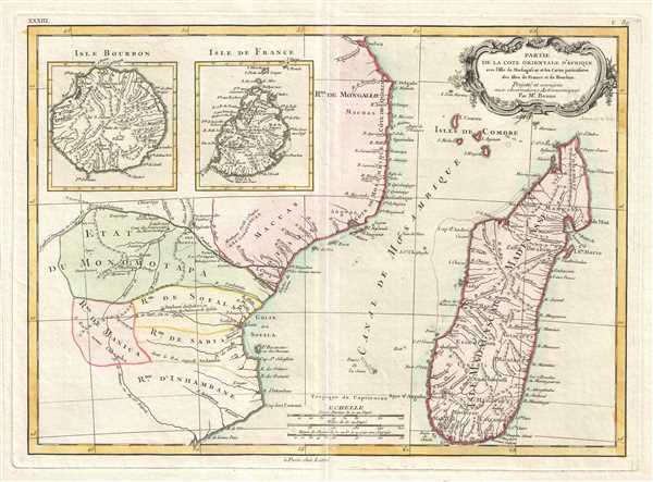
Partie de la Cote Orientale D'Afrique avec L'Isle de Madagascar et les Cartes particulieres des Isles de France et de Bourbon.
sold
- Digital Map Information
- Suitable for large format printing
- DPI: 300
- File Size: 4.44 MB
- File Type: ZIP / TIFF
- ICC color profile embedded
- Delivered instantly via download link
This is a 1770 Rigobert Bonne map of southeastern Africa and Madagascar. The map depicts the East African coastline of modern-day Mozambique and the island of Madagascar. Inset maps of the islands of Réunion (Isle Bourbon) and Mauritius (Isle de France). This ... (more details)
Includes a nearly accurate depiction of the Blue Nile!

Nubie et Abissinie Projettée et assujettie aux observations Astronomiques.
sold
- Digital Map Information
- Suitable for large format printing
- DPI: 300
- File Size: 6.24 MB
- File Type: ZIP / TIFF
- ICC color profile embedded
- Delivered instantly via download link
This is a 1771 Rigobert Bonne map of Nubia and Abyssinia. The map depicts from Aswan, Egypt to modern-day Ethiopia and from modern-day Sudan to Saudi Arabia. The modern-day countries of Eretria, Djibouti and Somalia are illustrated and border the Red Sea, ... (more details)
Utilizes the Ptolemaic two lake theory for the course of the Nile River.
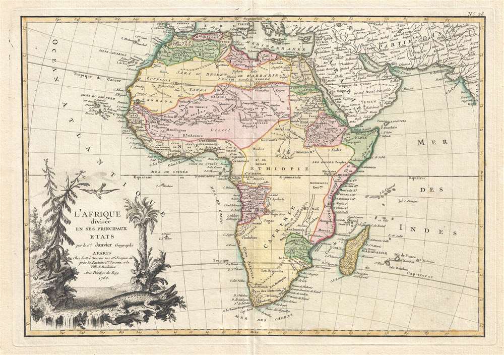
L'Afrique divisée en ses Principaux Etats.
sold
- Digital Map Information
- Suitable for large format printing
- DPI: 300
- File Size: 6.88 MB
- File Type: ZIP / TIFF
- ICC color profile embedded
- Delivered instantly via download link
This is a 1762 Jean Janvier map of Africa. The map depicts the entire continent along with Madagascar and parts of Persia and Arabia. The continent into various regions with color-coding dependent upon to the colonial power active in the region. The ... (more details)
This region is one of the major focuses of international relations today.

Carte de L'Empire de Perse.
sold
- Digital Map Information
- Suitable for large format printing
- DPI: 300
- File Size: 6.33 MB
- File Type: ZIP / TIFF
- ICC color profile embedded
- Delivered instantly via download link
This is a 1771 Rigobert Bonne map of Persia. The map depicts from the Black Sea to the Persian Gulf and from the Caspian Sa to the Indus Valley. The modern-day nations of Iran, Iraq, Kuwait, Afghanistan, Georgia, Armenia, and Azerbaijan are ... (more details)
Identifies the Sea of Korea.
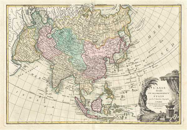
L'Asie, divisée en ses Principaux Etats.
$440.00
Acquire
- Digital Map Information
- Suitable for large format printing
- DPI: 300
- File Size: 7.44 MB
- File Type: ZIP / TIFF
- ICC color profile embedded
- Delivered instantly via download link
This is a 1771 Jean Janvier map of Asia. The map depicts from Africa and the Mediterranean to Bering Strait (Detroit du Norte ou d'Anian) and from Nova Zembla and the Arctic Ocean to Java and New Guinea. One of the most interesting ... (more details)
Depicts Poland before the First Partition.
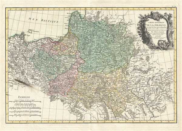
Carte Generale de la Pologne avec tous les Etats qui en dependent.
sold
- Digital Map Information
- Suitable for large format printing
- DPI: 300
- File Size: 7.46 MB
- File Type: ZIP / TIFF
- ICC color profile embedded
- Delivered instantly via download link
This is a 1762 Giovanni Antonio Bartolomeo Rizzi-Zannoni map of Poland and Lithuania. The map depicts from Denmark and Germany to Russia and from Livonia to Hungary, including Lithuania, Prussia, Greater Poland, Lesser Poland, and ... (more details)
Labels Mecca, Medina, and Jerusalem.

Carte de l'Arabie qui se divise en Arabie Pétrée, Deserte et Heureuse, Projettée et assujettie aux Observations Celestes.
sold
- Digital Map Information
- Suitable for large format printing
- DPI: 300
- File Size: 5.06 MB
- File Type: ZIP / TIFF
- ICC color profile embedded
- Delivered instantly via download link
This is a 1771 Rigobert Bonne map of the Arabian Peninsula. The map depicts from the Mediterranean Sea to the Indian Ocean and from the Red Sea to the Persian Gulf. The modern-day of Saudi Arabia, Israel, Jordan, Kuwait, Iraq, ... (more details)
Very rare geological survey of Hong Kong!
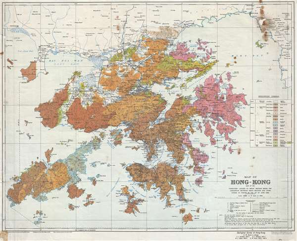
Map of Hong-Kong : and of the territory leased to Great Britain under the convention between Great Britain and China signed at Peking on the 9th of June 1898.
sold
- Digital Map Information
- Suitable for large format printing
- Full resolution TIFF file
- ICC color profile embedded
- Delivered instantly via download link
This is a scarce large format 1936 geological survey of Hong Kong issued by the British Ordnance Survey and the War Office. The map covers all of Hong Kong, as well as Lan Tao, Lamma, the New Territories, and Kowloon. Color ... (more details)
One of artist Kieth Ward's earliest works.

Welcome to Simmons Corners Tucker County Where Radio's Little Orphan Annie Has Had So Many Thrilling Adventures.
sold
- Digital Map Information
- Suitable for large format printing
- File Size: 17.07 MB
- File Type: ZIP / TIFF
- ICC color profile embedded
- Delivered instantly via download link
An uncommon 1936 Map of the idyllic fictional town of Simmons Corners, Tucker County, made popular by the Little Orphan Annie radio show. The radio show is based upon a newspaper comic strip by the same name by Harold Gray. The show, which was set in the fictional rural American community of Simmons Corners, is praised as being the oldest American children's radio program. It was released in 1931 and ran until 1942. While Gray's original comic was often charged with political content, the radio show, which was sponsored by Ovaltine, was largely an advertisement for that product, the promotion of which consumed nearly half of each 15-minute episode. Nonetheless, the show became enormously popular with children across the country. Ovaltine further capitalized on the show by introducing a series of 'premiums' obtainable only by mail with a set number of 'proofs of purchase.' Among the premiums were coffee mugs, secret decoder rings, and this 1936 map of Annie's stomping ground, Simmons Corners. The map is accompanied by its original shipping envelope addressed to one Marion Heck of Chicago Illinois. (more details)
Depicts seven of the planets, Juno, Ceres, and Pallas in the asteroid belt, and a comet!

Maquina del Universo segun Copernico. El Circulo maximo, representa la bobeda del Firmamento, su Centro, el Sol: y su vacio en el que navegam los Planetas y demas cuerpos la Atmosfera.
sold
This is a c. 1840 Pedro Martín de López armillary sphere or orrery of the solar system. The orrery depicts, in order, the Sun at the center, followed by Mercury, Venus, Earth, Mars, the asteroids / dwarf planets Juno, Ceres, ... (more details)
Unusual spinning wheel chart or map advertisement for Kellogg's cereal with information about each state in the U.S.

Kellogg's Wheel of Knowledge Interesting Facts about the United States.
sold
- Digital Map Information
- Suitable for large format printing
- File Size: 0.75 MB
- File Type: ZIP / TIFF
- ICC color profile embedded
- Delivered instantly via download link
This is a 1931 Kellogg's Wheel of Knowledge. This map or chart is a spinning wheel attached to some cardboard. Around the rim of the wheel are the names of the 48 states (Alaska and Hawaii were not yet states in 1931). Boxes ... (more details)
Outstanding Pictorial map of Alaska!
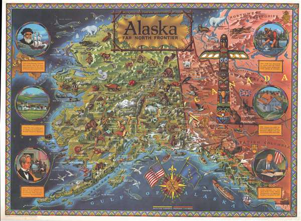
Alaska Far North Frontier.
sold
- Digital Map Information
- Suitable for large format printing
- File Size: 59.19 MB
- File Type: ZIP / TIFF
- ICC color profile embedded
- Delivered instantly via download link
This is a 1959 R. Klegston Rude pictorial map of Alaska. The map depicts the newly-proclaimed state of Alaska from the Bering Sea to the Canadian provinces of the Yukon, Northwest Territories, and British Columbia and from ... (more details)
The second earliest obtainable map of New York City. Issued just after the outbreak of the American Revolutionary War.
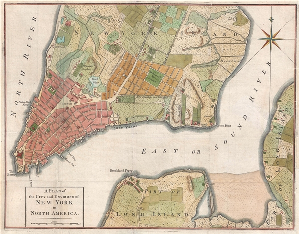
A Plan of the City and Environs of New York in North America.
sold
- Digital Map Information
- Suitable for large format printing
- DPI: 300
- File Size: 4.37 MB
- File Type: ZIP / TIFF
- ICC color profile embedded
- Delivered instantly via download link
A rare and important map of New York City issued in John Hinton's Universal Magazine in 1776 shortly following the outbreak of the American Revolutionary War. Considered the second earliest obtainable plan of New York ... (more details)
Extremely rare religious broadside printed in Harrisburg, PA.

Representation of the different Ways leading to Everlasting Life or Eternal Damnation.
sold
- Digital Map Information
- Suitable for large format printing
- DPI: 300
- File Size: 5.37 MB
- File Type: ZIP / TIFF
- ICC color profile embedded
- Delivered instantly via download link
A rare c. 1830 Gustav Sigismund Peters allegorical broadside illustrating the paths to heaven and hell, or as he refers to them 'Everlasting Life or Eternal Damnation'. This broadside was issued in Harrisburg, PA. ... (more details)
Details William Booth's 'Scheme of Social Selection and Salvation' - he was the founder of the Salvation Army!

In Darkest England, And the Way Out. Salvation Army Social Campaign, Work for All.
sold
- Digital Map Information
- Suitable for large format printing
- File Size: 4.88 MB
- File Type: ZIP / TIFF
- ICC color profile embedded
- Delivered instantly via download link
This is a c.1890 William Booth chart of his 'Scheme of Social Selection and Salvation.' The chart depicts various aspects of the rather complex scheme. A 'Key to the Chart' is included at the bottom of the page ... (more details)
Incredibly detailed map of the Middle East - labels Jerusalem!

Carte la plus nouvelle et plus-exacte du Royaume de Perse, avec ses Côtes, Villes Maritimes, tous les Pays qui en dependent, et ses Lieux circonvoisins.
sold
- Digital Map Information
- Suitable for large format printing
- DPI: 300
- File Size: 5.34 MB
- File Type: ZIP / TIFF
- ICC color profile embedded
- Delivered instantly via download link
This is a hand colored 1719 Pieter van der Aa map of the Middle East and Iran. The map depicts from the Black Sea and the Caspian Sea to the Persian Gulf and the Red Sea and from the Mediterranean Sea and ... (more details)
Created expressly to detail the construction of the Vauban citadels at Strasbourg and Kehl.

Plan de Strasbourg sa Citadelle et le Fort de Kehl avec tout les Ouvrages qui ont este construit Pendant La Paix
sold
- Digital Map Information
- Suitable for large format printing
- DPI: 300
- File Size: 24.35 MB
- File Type: ZIP / TIFF
- ICC color profile embedded
- Delivered instantly via download link
This is a rare 1735 Antoine du Chaffat city map or plan of Strasbourg, France. The map depicts the city of Strasbourg and the land surrounding the city on the left side of the Rhine River and the Fort and ... (more details)
Gorgeous pictorial map of a tropical paradise!
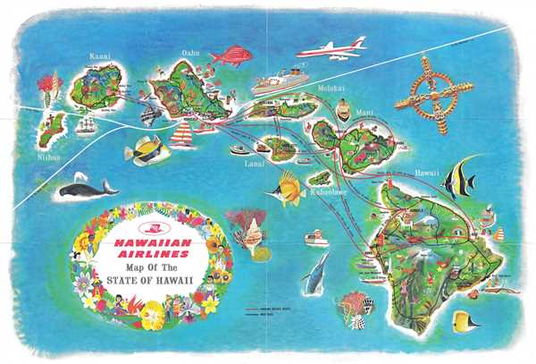
Hawaiian Airlines Map of the State of Hawaii.
sold
- Digital Map Information
- Suitable for large format printing
- File Size: 9.73 MB
- File Type: ZIP / TIFF
- ICC color profile embedded
- Delivered instantly via download link
This is a 1963 Hawaiian Airlines map of Hawaii. The map depicts the Hawaiian archipelago including the islands of Hawaii, Maui, Kahoolawe, Lanai, Molokai, Oahu, Kauai and Nihau. Beautifully illustrated, ... (more details)
Stunning map of Sicily from the Cologne School.
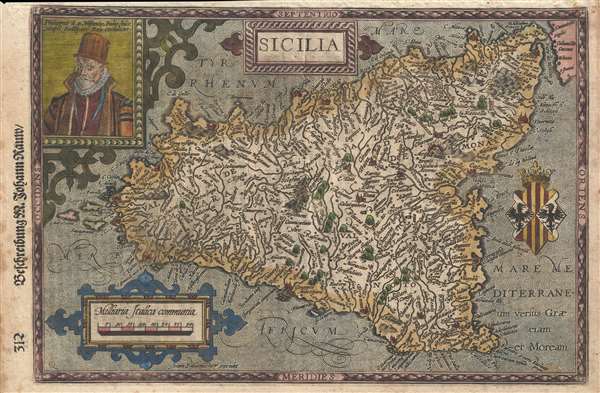
Sicilia.
sold
- Digital Map Information
- Suitable for large format printing
- DPI: 300
- File Size: 3.62 MB
- File Type: ZIP / TIFF
- ICC color profile embedded
- Delivered instantly via download link
A rare 1600 map of Sicily, Italy, by Matthias Quad and Johann Bussemacher. There is an engraved portrait of Phillip II of Spain, who, among his other titles, was also King of Sicily. I the upper left ... (more details)