
Hawaii as part of the greater Japanese Empire.

標準大東亞分圖 : ハワイ誻島 / Standard Map of the Great East Co-Prosperity Sphere. Hawaiian Islands.
sold
- Digital Map Information
- Suitable for large format printing
- Full resolution TIFF file
- ICC color profile embedded
- Delivered instantly via download link
This is a 1943 (Showa 18) Seitosha (正統社) map of Hawaii from the Greater East Asian Co-Prosperity Sphere series. The inclusion of the map in the Greater East Asian Co-Prosperity Sphere underscores the extent of Japan's imperial ambitions for the archipelago. It is part of a wider anti-western, anti-western-imperialism propaganda message promoted by Imperial Japan throughout the 1930s and 40s. (more details)
First garden cemetery in the United States.

Mount Auburn, with a Catalogue of the Proprietors and Tombs.
sold
- Digital Map Information
- Suitable for large format printing
- Full resolution TIFF file
- ICC color profile embedded
- Delivered instantly via download link
This is an 1845 Nathaniel Dearborn map of Mount Auburn Cemetery, Watertown, Massachusetts. When this map was issued, Mount Auburn Cemetery was among the most visited destinations in the United States, celebrated as the first garden cemetery in the country. (more details)
More uniquely colorful...

The 8th Annual Original + more Uniquely Colorful than Ever Blissberger Map + Calendar of Coconut Grove.
sold
This is a near-psychedelic 1980 'Blissberger' pictorial map of Coconut Grove, Miami, Florida. The map is a colorful celebration of local businesses and culture. (more details)
Key River to Humboldt's Explorations of the Orinoco system.
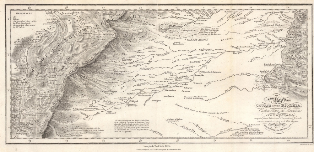
Map of the Course of the Rio Meta, and a part of the Eastern Chain of the Mountains of New Granada.
sold
- Digital Map Information
- Suitable for large format printing
- File Size: 8.59 MB
- File Type: ZIP / TIFF
- ICC color profile embedded
- Delivered instantly via download link
This is an 1818 Alexander von Humboldt map of the Rio Meta (Meta River) in Colombia and Venezuela. The Meta was one of the key waterways that Humboldt navigated while studying the intricate river systems of the Orinoco Basin. His observations and detailed descriptions of the Río Meta’s geography, flora, and fauna contributed to his broader understanding of South America’s natural environment. The map was compiled to illustrate Humboldt's epic voyage through South America, resulting in his Cosmos, an era-defining scientific work. (more details)
Unique constructed manuscript plan to renovate Paris by the architect of the Odéon.
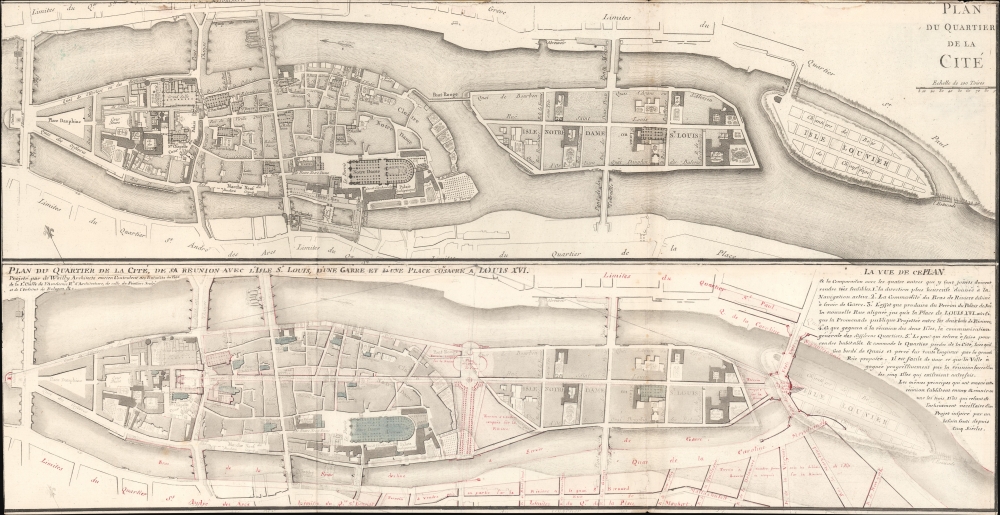
Plan du Quartier de la Cité. / Plan due Quartier de la Cité, de sa Reunion avec L'Isle St. Louis, d'une Garre et d'une Place Consacre a, Louis XVI.
sold
- Digital Map Information
- Suitable for large format printing
- File Size: 14.15 MB
- File Type: ZIP / TIFF
- ICC color profile embedded
- Delivered instantly via download link
A most unique and intriguing 1789 map of the Cité quarter, Paris, with copious manuscript, illustrating the bold plan of French 'Architecte du Roi' and designer of the Odéon, Charles de Wailly, to unite Paris's Île de la Cité with neighboring Île Saint-Louis. The plan, though greeted at the 1789 Paris Salon with much enthusiasm, floundered due to unfortunate timing: it was proposed at the outbreak of the French Revolution (1789 - 1799). It is an epic 'could-have-been' by one of Paris's most famous and influential architects. (more details)
1861 Battle of Shanghai.

Plan de la Ville de Shanghai avec Les Concessions Étrangères 31, Octobre, 1861.
sold
- Digital Map Information
- Suitable for large format printing
- File Size: 32.6 MB
- File Type: ZIP / TIFF
- ICC color profile embedded
- Delivered instantly via download link
A rare French-language map of Shanghai, China, published in 1861 in the wake of the Battle of Shanghai, the Second Opium War, and the Taiping Rebellion. (more details)
Culmination of 60 years of GLO surveying.
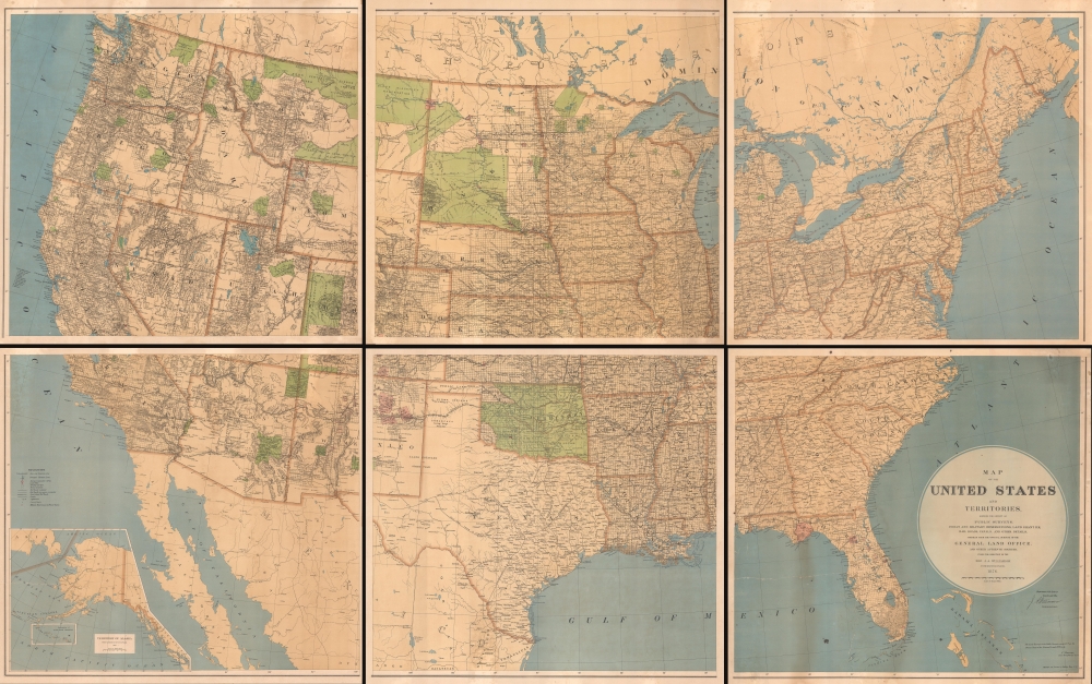
Map of the United States and Territories showing the extent of Public Surveys, Indian and Military Reservations, Land Grant R.R., Railroads, Canals, and other details, compiled from the official surveys of the General Land Office, and other authentic sources, under the direction of the Hon. J. A. Williamson, Commissioner, 1876.
sold
- Digital Map Information
- Suitable for large format printing
- File Size: 238.16 MB
- File Type: ZIP / TIFF
- ICC color profile embedded
- Delivered instantly via download link
An impressive and rare 1876 wall map of the United States drafted by Charles Roeser and issued by the General Land Office under James A. Williamson. The culmination of 60 years of GLO survey work, this map is the state-of-the-art cartographic representation of the United States in the late 19th century. (more details)
Finest obtainable Colonial Era map of the Gulf Coast around the Mississippi Delta and Louisiana.
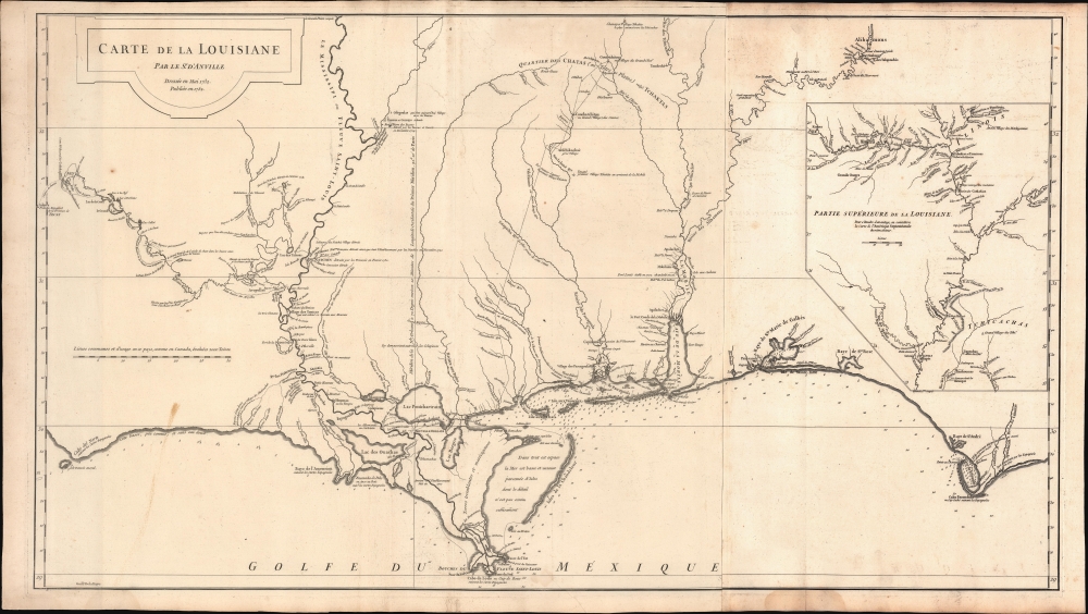
Carte de la Louisiane.
$1,400.00
Acquire
- Digital Map Information
- Suitable for large format printing
- DPI: 600
- File Size: 933.1 MB
- File Type: ZIP / TIFF
- ICC color profile embedded
- Delivered instantly via download link
A lovely example of the important 1732/52 map of the Gulf Coast and lower Mississippi River Valley by Jean Baptiste Bourguignon d'Anville. The map is significant as the largest and most comprehensive map of the Gulf littoral to appear during the French period of Louisiana. (more details)
Supposed Aegean Theater of the Morean War.

Arcipelago Mar Egeo con le Coste del Medesimo.
sold
- Digital Map Information
- Suitable for large format printing
- File Size: 21.44 MB
- File Type: ZIP / TIFF
- ICC color profile embedded
- Delivered instantly via download link
This is the beautiful 1685 Cantelli da Vignola map of the Greek Islands in the Aegean Sea. It was issued at the beginning of the 1684-1699 Morean War between Venice and the Ottoman Empire. (more details)
Iconic Tolkien promotional poster map.

A Map of Middle-Earth.
sold
This is the iconic 1970 rare poster map of J. R. R. Tolkien's Middle Earth drawn by Pauline Diana Baynes to promote the George Allen and Unwin release of the Lord of the Rings. Tolkien heaped praise upon Baynes' work, saying, 'They are more than illustrations, they are a collateral theme. I showed them to my friends whose polite comment was that they reduced my text to a commentary on the drawings.' (more details)
Anatolia as known to Ancient Rome.
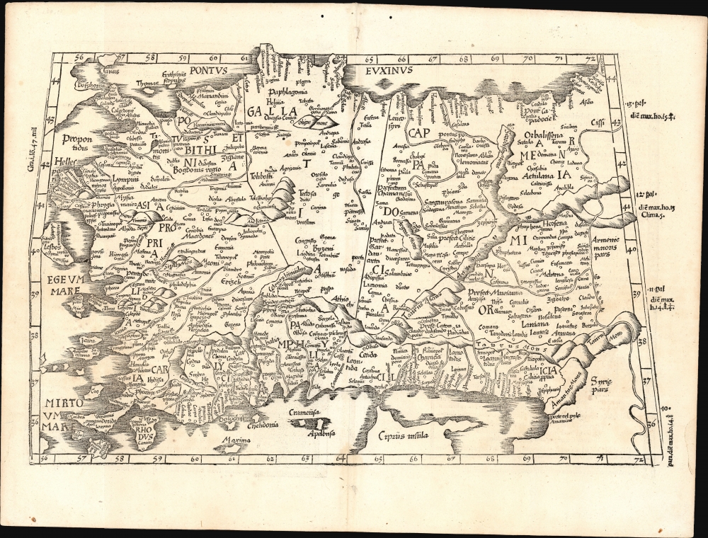
[Tabula I. Asiae].
$1,000.00
Acquire
- Digital Map Information
- Suitable for large format printing
- Full resolution TIFF file
- ICC color profile embedded
- Delivered instantly via download link
This is Laurent Fries' 1525 edition of Martin Waldseemüller's Ptolemaic map of Anatolia, one of the earliest generally acquirable maps of what would become modern-day Turkey. (more details)
'Like wow, these people are really beautiful, the cops, the storekeepers, the army, everybody.'

Woodstock. The East Village Other.
sold
A remarkable 1969 'yellow submarine' style surrealistic map to the Woodstock Music Festival published as the front page of the counterculture periodical East Village Other, just two days before the epic three-day weekend. (more details)
Shanghai's pre-war Golden Age.

New Map of Shangahi. / 上海新地圖
sold
- Digital Map Information
- Suitable for large format printing
- File Size: 39.14 MB
- File Type: ZIP / TIFF
- ICC color profile embedded
- Delivered instantly via download link
An extremely rare bi-lingual Chinese/English map of Shanghai, China, here in its second edition, issued by the Shanghai-Japanese cartographer Sugie Fusazō (杉江房造) in March of 1930, or Showa 5. This is the second of Sugie Fusazō's maps to include a panorama of the city (more specifically, the Bund). It was the first to depict the Bund from across the Huangpu River, a convention copied on the 1932 Cross House map (Shanghai-crosshouse-1932) and one that would be followed in many later editions of the map. (more details)
First American map of North Carolina. Shows the Moravian Settlement of Wachovia.
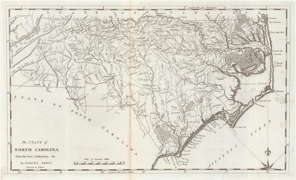
The State of North Carolina from the best Authorities etc.
sold
- Digital Map Information
- Suitable for large format printing
- Full resolution TIFF file
- ICC color profile embedded
- Delivered instantly via download link
This is a 1795 first state example of the Samuel Lewis map of North Carolina, the earliest specific map of that state printed in the United States. It is also one of the few maps to show the Moravian Settlement of Wachovia, near modern-day Winston-Salem. (more details)
Florida as an Archipelago.
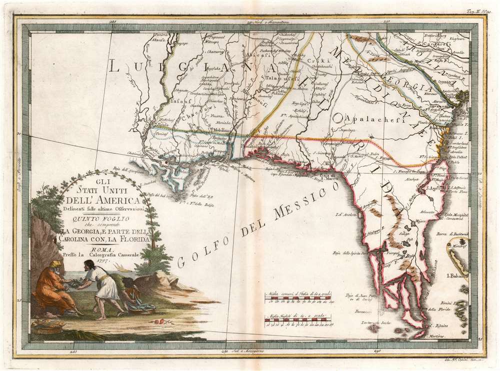
Gli Stati Uniti dell' America delineati sulle ultime Osservazioni. Quinto Fogloi che comprende La Georgia, e parte della Carolina con, la Florida.
sold
- Digital Map Information
- Suitable for large format printing
- DPI: 600
- File Size: 13.92 MB
- File Type: ZIP / TIFF
- ICC color profile embedded
- Delivered instantly via download link
An elegant 1797 Giovanni Maria Cassini map of the southeastern part of the fledgling United States. (more details)
Combines beautiful color with Egyptian history, culture, and technological progress.
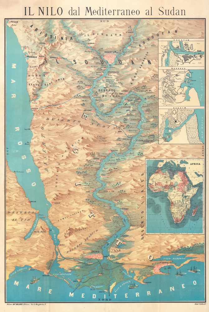
Il Nilo dal Mediterraneo al Sudan.
sold
- Digital Map Information
- Suitable for large format printing
- Full resolution TIFF file
- ICC color profile embedded
- Delivered instantly via download link
This is a c. 1874 Antonio Vallardi chromolithograph bird's-eye view map of the Nile River of the Nile Delta to Khartoum. The view combines brilliant color with stunning detail to combine Egyptian history with modern progress, such as the railroad network and the Suez Canal. (more details)
One of the worst railroad disasters in Georgia history.

Map of the Charleston and Savannah Railway, Savannah Florida and Western Railway, South Florida R.R. And all the Routes operated by the Peoples Line of Steamers and Plant Steamship Line Known as the Plant System.
sold
- Digital Map Information
- Suitable for large format printing
- Full resolution TIFF file
- ICC color profile embedded
- Delivered instantly via download link
This is a December 1887 Crawford Print railroad map of Florida and southern Georgia. Manuscript notes on map and binder record the travels of one E.E. West through Florida, including a harrowing railroad accident in Georgia - the worst in Georgia History. (more details)
Road travel throughout the Arab-speaking world.

الوطن العربي / [The Arab World].
sold
A scarce and colorful large-format folding transportation map of the Arab World, prepared by Abdel-Aal Mohammed Rashdan and printed in 1964 by the Arab Federation of Touring Car Clubs and Associations. (more details)
זאת הארץ אשר נפל לכם בנחלה… (במדבר ל''ג, ב')

[Land of Israel.] / .ארץ ישראל
sold
- Digital Map Information
- Suitable for large format printing
- File Size: 40.17 MB
- File Type: ZIP / TIFF
- ICC color profile embedded
- Delivered instantly via download link
This is a 1934 Jewish National Fund Zionist map of Israel highlighting the Jewish National Fund's (JNF) push to acquire land in British Mandate Palestine for Jewish settlement. The map propagandizes the JNF's Zionist agenda and celebrates their significant successes. The JNF, founded as part of the early 20th-century Zionist movement, played a critical role in establishing a Jewish presence in Palestine in the decades before the creation of the Israeli state. (more details)
The drunk rabbit is still dodging cars on the road to Timberline Lodge.

Skisterical Map of Mt. Hood Recreation Area with Space for 50,000 Skiers. Apologies to Mt. Hood and the U.S. Forestry Service Can't Be Guaranteed Against Lots of Errors.
sold
This is a 1973 Darr Company comic pictorial place-mat map of Mt. Hood, Oregon, illustrating its history and folklore. While the true meaning of the pink elephant has been lost to history, the drunk rabbit is still dodging cars on the road to Timberline Lodge. (more details)