
Rare first edition Burritt charts with individually colorized constellations.

Northern Circumpolar Map for each Month in the Year. Southern Circumpolar Map for each Month in the Year.
sold
- Digital Map Information
- Suitable for large format printing
- DPI: 300
- File Size: 12.27 MB
- File Type: ZIP / TIFF
- ICC color profile embedded
- Delivered instantly via download link
This is a beautiful hand colored set of the northern and southern circumpolar maps by Elijah Burritt. This pair of maps illustrates the night sky and constellations of both the northern hemisphere and southern hemisphere respectively. Constellations are drawn in ... (more details)
Scarce map illustrating original survey work of the Mineral Districts around Lake Superior.
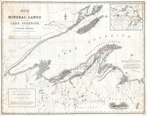
Map of that Part of the Mineral Lands adjacent to Lake Superior, ceded to the United States by the Treaty of 1842 with the Chippewas. Comprising that District lying between Chocolate River and Fond du Lac, under the superintendency of Genl. John Stockton, U.S. Agent.
sold
- Digital Map Information
- Suitable for large format printing
- File Size: 81.8 MB
- File Type: ZIP / TIFF
- ICC color profile embedded
- Delivered instantly via download link
A rarely seen and massive 1845 government issued map of the western part of Lake Superior drawn to illustrate mining districts. The map covers from Cass Bay and Grand Island westward as far as the American Fur Company Depot at the mouth of the River St. Louis, or ... (more details)
Spectacular 15 inch Celestial Globe.

Cary's New Celestial Globe, on which are carefully laid down the whole of the Stars and Nebulae contained in the Catalogues of Wollaston, Herschel, Bode, Piazzi, Zach and c. calculated to the year 1820.
sold
A fine 15-inch example of Cary's New Celestial Globe . The stars and constellations depicted are derived from the astronomical catalogues of Wollaston, Herschel, Bode, Piazzi, Zach and others, calculated to the Year 1820. This globe was made and sold by J. and ... (more details)
Rare large format souvenir map of New York City.
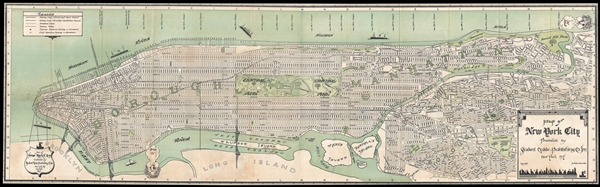
Map of New York City Published by Student Guide Publishing Co. Inc. New York, N.Y.
sold
- Digital Map Information
- Suitable for large format printing
- File Size: 20.44 MB
- File Type: ZIP / TIFF
- ICC color profile embedded
- Delivered instantly via download link
A rare 1930 map of New York City published by the 'Student Guide Publishing Company.' The map covers the whole of Manhattan as well as parts of Queens. The map shows the city's streets, parks, and transportation network. Parks, rivers, islands, and more are ... (more details)
Interesting and unusual historical map showing the extant of Islamic conquests under Mohammed.

Eslem or the Countries Conquered and Converted by Muhhammed and His Followers.
sold
- Digital Map Information
- Suitable for large format printing
- DPI: 300
- File Size: 12.02 MB
- File Type: ZIP / TIFF
- ICC color profile embedded
- Delivered instantly via download link
A rare 1829 John Thomson historical map illustrating the conquests and conversions of Mohammed and his followers. The map, which is centered on Arabia, covers from the Canary Island to Japan and from Scandinavia to South Africa. Thomson compiled this map ... (more details)
Rare map of the Marches of Alexander the Great.
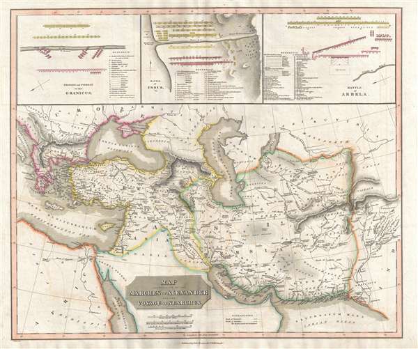
Map Illustrative of the Marches of Alexander and the Voyage of Nearchus
sold
- Digital Map Information
- Suitable for large format printing
- DPI: 300
- File Size: 12.85 MB
- File Type: ZIP / TIFF
- ICC color profile embedded
- Delivered instantly via download link
A rare 1829 John Thomson historical map illustrating the Battles and Marches of Alexander the Great. Centered on the Caspian Sea, the map cover from the Adriatic Sea to Indus River Valley and from Crimea to the Red Sea, including all of the modern day ... (more details)
Arresting perspective presentation of Cairo during the Anglo-Egyptian War.
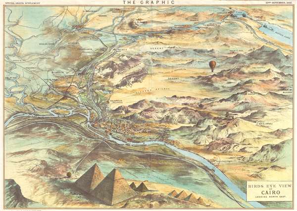
Birds Eye View of Cairo Looking North East.
sold
- Digital Map Information
- Suitable for large format printing
- File Size: 13 MB
- File Type: ZIP / TIFF
- ICC color profile embedded
- Delivered instantly via download link
An uncommon 1882 bird's-eye view map of Cairo, Egypt. This view was issued as a supplement to the 23rd, September, 1882 issue of The Graphic . The view presets Cairo looking north east from somewhere high above the Treat Pyramids of Giza, which ... (more details)
Interesting pictorial map of Acadia National Park, Mount Desert Island, and Frenchman's Bay.

Sunrise on Acadia This National Park Established in 1919.
sold
- Digital Map Information
- Suitable for large format printing
- File Size: 15.56 MB
- File Type: ZIP / TIFF
- ICC color profile embedded
- Delivered instantly via download link
A very attractive 1966 pictorial map of Mount Desert Island, Frenchman bay, and the Schoodic Peninsula. The map was drawn by Augustus D. Phillips, a Northeast Harbor native, in memory of George B. Dorr, Charles, W. Eliot, and John D. Rockefeller ... (more details)
Extremely rare view of Moravia, in the Finger Lakes, New York

Moravia, N.Y.
sold
- Digital Map Information
- Suitable for large format printing
- File Size: 11.6 MB
- File Type: ZIP / TIFF
- ICC color profile embedded
- Delivered instantly via download link
A rare 1885 Lucien Rinaldo Burleigh view of Moravia, New York. Moravia is a small picturesque town in the Finger Lakes Region of Cayuga County New York. The view details the town center and is oriented to the northeast. It covers from School ... (more details)
Graphic and informative map of the Southern States at the end of the American Civil War.
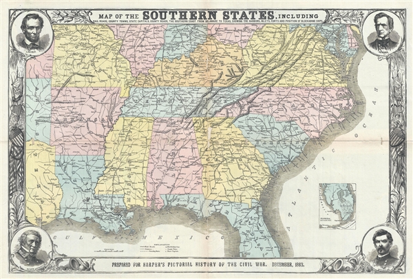
Map of the Southern States, including Rail Roads, County Towns, State Capitals, Country Roads, the Southern Coast from Delaware to Texas, showing the Harbors, Inlets, Forts and Positions of Blockading Ships.
sold
- Digital Map Information
- Suitable for large format printing
- File Size: 18.48 MB
- File Type: ZIP / TIFF
- ICC color profile embedded
- Delivered instantly via download link
An impressive and informative 1863 map of the Southern States of the United States at the end of the American Civil War. The map covers from the Chesapeake Bay to, roughly, Cape Canaveral, Florida, and westward along the Gulf Coast as far as ... (more details)
Working nautical chart of the Caribbean.
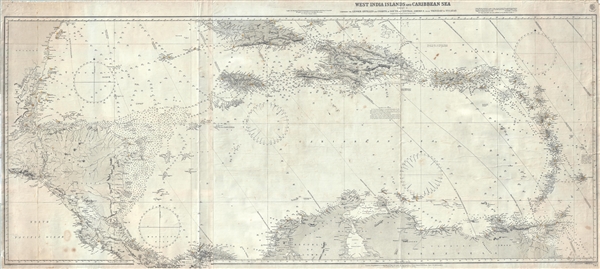
West India Island and Caribbean Sea Sheet II comprising the Lesser Antilles and Coasts of South and Central American from Trinidad to Yucatan.
sold
- Digital Map Information
- Suitable for large format printing
- File Size: 40.16 MB
- File Type: ZIP / TIFF
- ICC color profile embedded
- Delivered instantly via download link
An impressive large scale 1913 blueback chart of the West Indies issued by the British Admiralty Hydrographic Office. The map covers from The Yucatan Peninsula to the Windward Islands (Lesser Antilles) and from Cuba to the Spanish Main, including all of Lake Maracaibo. The map identifies shoals, reefs, and other undersea dangers with note providing a wealth of practical information for the mariner. There are countless depth soundings in fathoms throughout. Light houses and light boats are highlighted in red and yellow. Inland there is limited topographical detail. (more details)
Uncommong sporting map of New Jersey showing the general distribution of wildlife including Fish, Deer, Fowl, and other Small Game.

Fish and Game Habitats Showing general distribution of fish and game - navei, introduce, and migratory- in the State of New Jersey.
sold
- Digital Map Information
- Suitable for large format printing
- File Size: 26.36 MB
- File Type: ZIP / TIFF
- ICC color profile embedded
- Delivered instantly via download link
A marvelous 1936 pictorial map of the state of New Jersey promoting sporting life by Samuel R. Steward and John H. Wright. The map covers the entire state of New Jersey. Superimposed on the map of are images of various game animals, as well ... (more details)
Beautiful 18th century map of France.

Carte Generale de France divisee par Gouvernements.
sold
- Digital Map Information
- Suitable for large format printing
- DPI: 300
- File Size: 6.68 MB
- File Type: ZIP / TIFF
- ICC color profile embedded
- Delivered instantly via download link
An attractive example of Rigobert Bonne's decorative 1771 map of France. Covers the entirety of France from Spain to Germany and from the British Channel to the Mediterranean. Divided into provinces with color coding according to region. ... (more details)
Tourist guide to Seattle by the Chamber of Commerce.
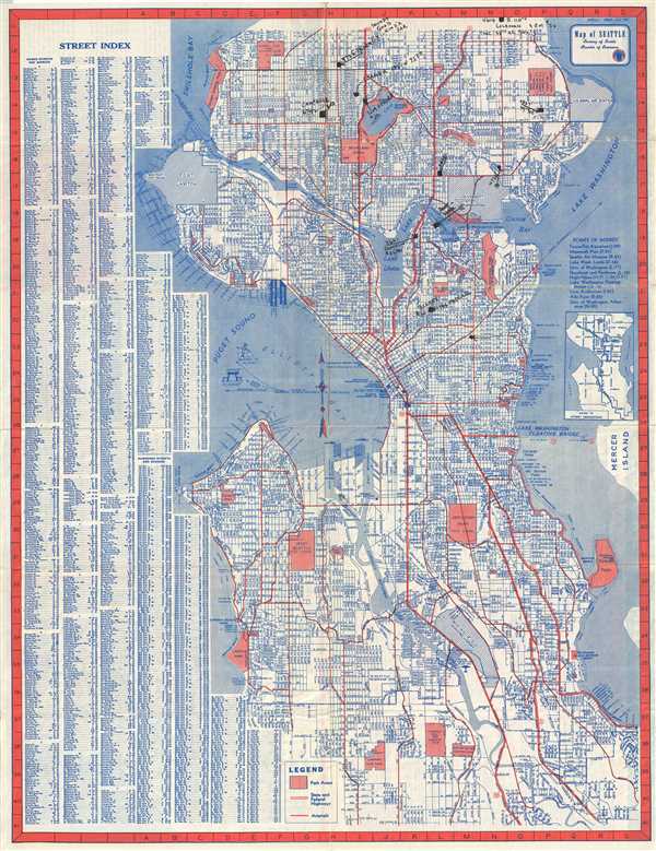
Map of Seattle.
sold
- Digital Map Information
- Suitable for large format printing
- File Size: 19.03 MB
- File Type: ZIP / TIFF
- ICC color profile embedded
- Delivered instantly via download link
This is a detailed c.1950 map or city plan of Seattle, Washington by Kroll Map Co. Inc. Covers the entire city in incredible detail noting streets, parks, lakes, bridges, street car lines, rivers, proposed expansions, lakes, and other ... (more details)
A classic view of Boston.

Bird's Eye View of Boston Harbor and South Shore to Provincetown Showing Steamboat Routes.
sold
- Digital Map Information
- Suitable for large format printing
- File Size: 11.68 MB
- File Type: ZIP / TIFF
- ICC color profile embedded
- Delivered instantly via download link
A remarkable chromolithograph map and view of Boston Harbor from Boston to Provincetown. The view includes all of Cape Cod Bay, Quincy Bay and Dorchester Bay with the communities of Boston, East Boston, South Boston, Dorchester, ... (more details)
Attractive map of the popular summer colony of Martha's Vineyard.
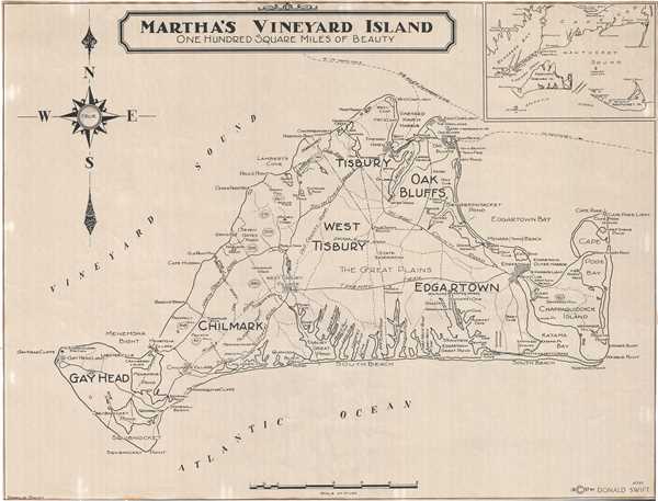
Martha's Vineyard Island One Hundred Square Miles of Beauty.
sold
- Digital Map Information
- Suitable for large format printing
- File Size: 11.3 MB
- File Type: ZIP / TIFF
- ICC color profile embedded
- Delivered instantly via download link
This is a lovely 1937 map of Martha’s Vineyard Island, Massachusetts by Donald Swift. It covers the entire island, popular summer colony, in beautiful detail noting towns, roads, trails, harbors, beaches, ponds, coves, bays, ... (more details)
Early map of Buenos Aires, Argentina.
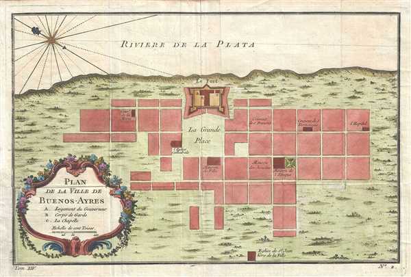
Plan de la Ville de Buenos-Ayres.
sold
- Digital Map Information
- Suitable for large format printing
- DPI: 300
- File Size: 2.87 MB
- File Type: ZIP / TIFF
- ICC color profile embedded
- Delivered instantly via download link
This is a beautiful 1758 map of Buenos Aires by Nicolas Bellin. Oriented with north to the southeast, the map depicts the forth and surrounding blocks and streets. Identifies some important buildings. The map also shows ... (more details)
Beautiful early map of Southern India.
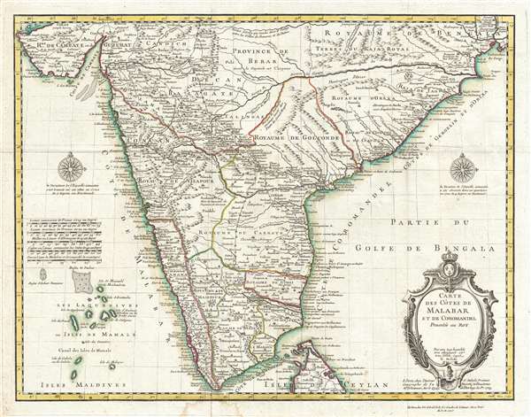
Carte des Cotes de Malabar et de Coromandel.
sold
- Digital Map Information
- Suitable for large format printing
- DPI: 300
- File Size: 13.67 MB
- File Type: ZIP / TIFF
- ICC color profile embedded
- Delivered instantly via download link
This is a beautiful 1745 map of southern India by Guillaume Delisle and Philippe Buache. The map covers southern India and the Malabar Coast from the Gulf of Kutch south to Cape Comorin and the northern half of Sri ... (more details)
Beautiful pictorial map of Venice.
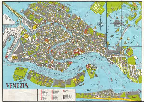
Venezia.
sold
- Digital Map Information
- Suitable for large format printing
- File Size: 12.8 MB
- File Type: ZIP / TIFF
- ICC color profile embedded
- Delivered instantly via download link
This is a beautiful c. 1940 map or city plan of Venice, Italy issued by the Unione Italiana Lotta alla Distrofia Muscolare. It covers Venice from the Pointe della Liberta Isola di S. Elena and from Giudecca north ... (more details)
Street map of Seattle, Washington.
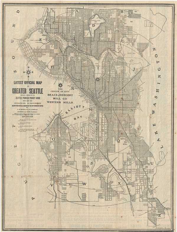
Latest Official Map of Greater Seattle.
sold
- Digital Map Information
- Suitable for large format printing
- File Size: 13.8 MB
- File Type: ZIP / TIFF
- ICC color profile embedded
- Delivered instantly via download link
This is a nice 1908 map or plan of the city of Seattle, Washington published y Arthur von Babo. Covers the entire city in incredible detail noting streets, parks, lakes, bridges, street car lines, rivers, and ... (more details)