
The map that named Madison's four famous lakes.
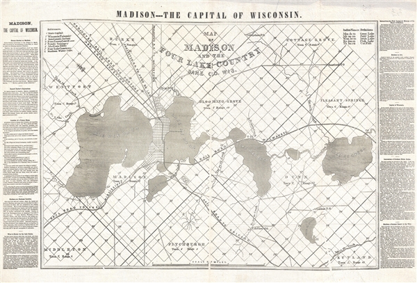
Map of Madison and the Four Lake Country, Dane Co. Wis.
sold
- Digital Map Information
- Suitable for large format printing
- File Size: 13.79 MB
- File Type: ZIP / TIFF
- ICC color profile embedded
- Delivered instantly via download link
An extremely rare 1856 broadside issued by Horace Greely and Wisconsin Governor Leonard J. Farwell promoting settlement in Madison, Wisconsin. This map is important as the first map to apply the modern names for all four of Madison's lakes. Oriented with ... (more details)
Delightful pictorial map of eastern Wisconsin, Green Bay, and the Fox River Valley.
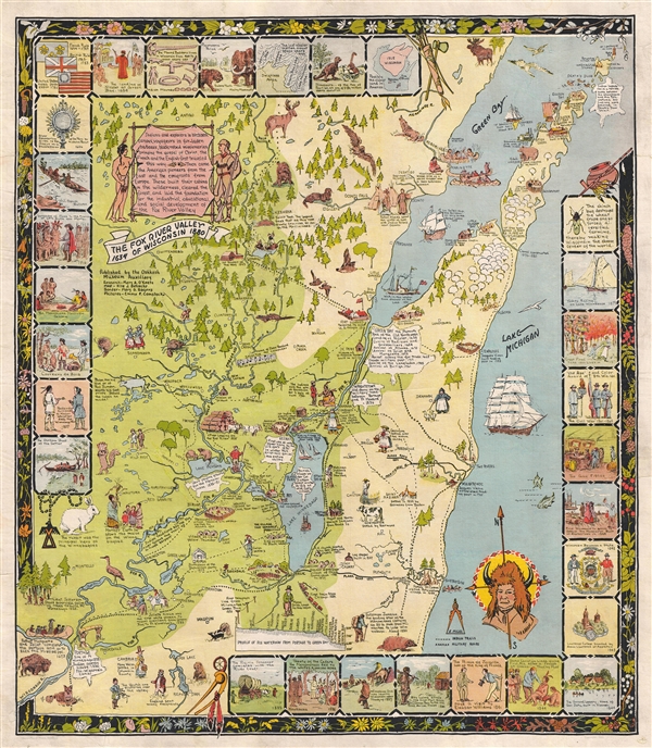
The Fox River Valley of Wisconsin 1634 - 1880.
sold
- Digital Map Information
- Suitable for large format printing
- Full resolution TIFF file
- ICC color profile embedded
- Delivered instantly via download link
A scarce pictorial map of the Fox River Valley, Wisconsin, by Nile J. Behncke. Centered on the Fox River Valley, map covers from Rock Island at the northern entrance to Green Bay, south to just beyond Sheboygan, and west as the Wisconsin River. The map ... (more details)
San Francisco as seen from Nob Hill.

San Francisco. 1856.
sold
- Digital Map Information
- Suitable for large format printing
- File Size: 4.98 MB
- File Type: ZIP / TIFF
- ICC color profile embedded
- Delivered instantly via download link
A highly appealing view map of San Francisco dating to 1856. Reveals San Francisco as seen from Nob Hill looking down California Street. Telegraph Hill appears on the left. Shows numerous buildings and ships throughout. The most important buildings ... (more details)
The first map to name Cape Cod and illustrate Prince Edward Island.
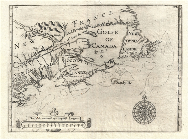
[Untitiled] New Englande, New Scotlande and New Foundlande.
sold
- Digital Map Information
- Suitable for large format printing
- DPI: 300
- File Size: 5.66 MB
- File Type: ZIP / TIFF
- ICC color profile embedded
- Delivered instantly via download link
An exceptional map of significant yet often underappreciated importance, this is Sir William Alexander's 1624 / 1625 map of New England, Nova Scotia, and Newfoundland. The map is notable for a number of first's including the first appearance of the ... (more details)
A uniquely Japanese combination of 'Kawaii' and military expansionism.

世界パノラマ大地圖 / World Panorama Daichi Sakai.
sold
- Digital Map Information
- Suitable for large format printing
- File Size: 38.48 MB
- File Type: ZIP / TIFF
- ICC color profile embedded
- Delivered instantly via download link
A remarkable 1933 Japanese issue pictorial map of the world drawn by Keizo Shimada (島田啓三). Centered on the Japanese Empire, which is highlighted in Red and includes both Taiwan and Korea, this map extends to cover the world with the exception of the Atlantic, which is only minimally addressed. The map presents a delightful array of vignettes intended to illustrate regional culture, flora, and fauna. Some of the images, despite being unbearably 'kawaii' are decidedly not politically correct, such as the rather intimidating looking Indian Chief in the Rocky Mountains. Despite the map's playful nature, Japan had already begun its grab for power in East Asia and the military aspect of the map is clear. Japanese destroyers patrol the western Pacific just as American destroyers stand watch on the Pacific Coast and in Hawaii. War was coming. (more details)
Scarce pocket map of New Haven illustrating Yalue University.
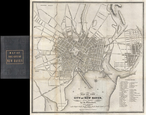
Map of the City of New Haven, from Surveys by R. Whiteford, Civil Engineer.
sold
- Digital Map Information
- Suitable for large format printing
- DPI: 300
- File Size: 4.97 MB
- File Type: ZIP / TIFF
- ICC color profile embedded
- Delivered instantly via download link
A scarce small format pocket map of New Haven, Connecticut, by R. Whiteford. The map covers the city of New Haven and the adjacent Fair-Haven. It extends from East Rock to Oyster Point and from Evergreen Cemetery to the Quinnipiac River. The ... (more details)
Attractive large format map of Brooklyn, New York. Includes the outer parts of Brooklyn that were incorporated into the borough after the turn of the century.

Rand McNally Map of Brooklyn.
sold
- Digital Map Information
- Suitable for large format printing
- File Size: 24.74 MB
- File Type: ZIP / TIFF
- ICC color profile embedded
- Delivered instantly via download link
This impressive map is a large format edition of Rand McNally's 1917 map of Brooklyn, New York. Unlike most earlier maps of Brooklyn, this map covers Brooklyn much as it appears today, extending from New York Harbor to Woodhaven (Queens) and from ... (more details)
One of the most beautiful and sumptuously illustrated maps of the 18th century.

Carte très curieuse de la Mer du Sud, contenant des Remarques Nouvelles et très utiles non seulement sur des Ports et Îles de cette Mer, mais aussy sur les principaux Pays de l'Amerique tant Septentrionale que Méridionale en a été faite.
sold
- Digital Map Information
- Suitable for large format printing
- DPI: 300
- File Size: 52.8 MB
- File Type: ZIP / TIFF
- ICC color profile embedded
- Delivered instantly via download link
One of the most spectacularly decorative maps of the 18th century, this is Henri Chatelain's magnificent 1719 map of the Americas and the Pacific. This sumptuously engraved map is centered on the American continent, but extends west to include ... (more details)
The earliest obtainable specific map of the Great Lakes.

La Louisiana, Parte Settentrionalle, Scoperta sotto la Protettione di Luigi XIV, Re di Francia et Descritta, e Dedicata Dal P. Cosmografo Coronelli, All'Illustriss, et Eccellentiss, S. Zaccaria Bernardi su dell Ecc. S. Francesco.
sold
- Digital Map Information
- Suitable for large format printing
- DPI: 300
- File Size: 5.43 MB
- File Type: ZIP / TIFF
- ICC color profile embedded
- Delivered instantly via download link
This rare 1694 production by Venetian cartographer Vincenzo Coronelli is the earliest and most important obtainable map of the Great Lakes and the headwaters of the Mississippi. Coronelli's map centers on Lake Superior, but covers all five ... (more details)
An iconic map of Shanghai, China, featuring a dramatic panoramic photograph of the Bund.

Saishin Shanhai chizu. Ōsaka Asahi Shinbunsha tokusen. / 大阪朝日新聞社特撰 . 最新上海地圖. / Osaka Asahi Shimbun Special Selection. Newest Map of Shanghai.
sold
- Digital Map Information
- Suitable for large format printing
- File Size: 16.55 MB
- File Type: ZIP / TIFF
- ICC color profile embedded
- Delivered instantly via download link
This is an uncommon and attractive 1932 map of Shanghai China. It was made before the start of the second Sino-Japanese war and World War II. Printed in the 7th year of Hirohito's reign, it depicts downtown Shanghai including the Chinese ... (more details)
Issued just a few years after the Great Chicago Fire of 1871.
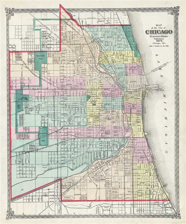
Map of the city of Chicago.
sold
- Digital Map Information
- Suitable for large format printing
- File Size: 9.91 MB
- File Type: ZIP / TIFF
- ICC color profile embedded
- Delivered instantly via download link
A fine 1875 map of Chicago issued by Warner and Beers. The map covers from Fullerton and Wrightwood Avenues to the Union Stockyards and from Central Park to Lake Michigan. All streets, wards, rail lines, public buildings, and parks are ... (more details)
Map of the Imperial Circle of Austria of the Holy Roman Empire.

Partie Meridionale du Cercle d'Autriche, qui comprend la basse partie du Duche de Stirie, le Duche de Carinthie, divise en haute et basse; le Duche de Carniole, divise en haute, basse, moyenne et intere. Carniole, et l'Istrie Imperiale.
sold
- Digital Map Information
- Suitable for large format printing
- Full resolution TIFF file
- ICC color profile embedded
- Delivered instantly via download link
This is a fine 1752 map of southern Austria and Slovenia by Robert de Vaugondy. It covers from Caorle in Venice, Italy east as far as Varazdin, Croatia and from Graz south as far as Segna in Croatia. Includes the modern day countries ... (more details)
18th century map of the Piedmont wine region of Italy.

Partie Occidentale de la Lombardie et pays circonvoisins, ou sont les Etats de Savoye, Piemont, Milan, Genes, Plaisance etc.
sold
- Digital Map Information
- Suitable for large format printing
- DPI: 300
- File Size: 20.69 MB
- File Type: ZIP / TIFF
- ICC color profile embedded
- Delivered instantly via download link
This is a scarce 1750 map of the western part of Lombardy in northern Italy by Robert de Vaugondy. It covers from Lake Geneva south as far as Nice and east as far as Pisa and depicts the regions of Savoy, Piedmont, Milan, Genoa and ... (more details)
Vaugondy's beautiful representation of France.

Le Royaume de France divise suivant les Gouvernemens generaux.
sold
- Digital Map Information
- Suitable for large format printing
- DPI: 300
- File Size: 19.85 MB
- File Type: ZIP / TIFF
- ICC color profile embedded
- Delivered instantly via download link
This is a fine 1750 map of France by Robert de Vaugondy. It covers the entirety of France from the English Channel to Corsica and Spain. The map renders the entire region in extraordinary detail offering both topographical and ... (more details)
First edition of Johnson's important Australia series.

Johnson's Australia.
sold
- Digital Map Information
- Suitable for large format printing
- File Size: 8.03 MB
- File Type: ZIP / TIFF
- ICC color profile embedded
- Delivered instantly via download link
A beautiful first edition example of A. J. Johnson's 1861 map of Australia. This is the first edition and earliest state in the Johnson Australia series. Depicts the continent with good detail along the coast and a largely ... (more details)
Map of the hill station of Ramanmalai or Ramgad in Maharashtra, India during British rule.
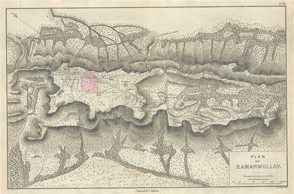
Plan of Ramanmullay.
sold
- Digital Map Information
- Suitable for large format printing
- DPI: 300
- File Size: 6.95 MB
- File Type: ZIP / TIFF
- ICC color profile embedded
- Delivered instantly via download link
This is a beautiful 1854 map by Pharoah and Company depicting Ramanmalai near Sandur town in the Indian state of Karnataka. It covers the hills near Sandur, known as the Ramanmalai block. The map notes beautifully rendered ... (more details)
Plan of Palakkad in Kerala India, at the time of British rule.
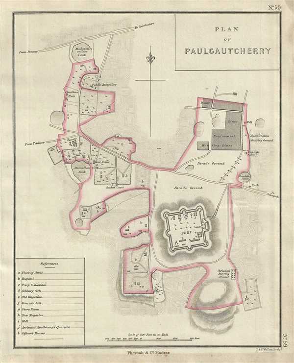
Plan of Paulgautcherry.
sold
- Digital Map Information
- Suitable for large format printing
- DPI: 300
- File Size: 2.34 MB
- File Type: ZIP / TIFF
- ICC color profile embedded
- Delivered instantly via download link
This is a lovely example of the 1854 Pharoah and Company map of Palakkad in Kerala, India. The map focuses on the area around the Palakkad Fort and notes fields, roads, official military buildings and topography. The title ... (more details)
Plan of Kamptee near Nagpur, India, during British rule.

Plan of Kamptee.
sold
- Digital Map Information
- Suitable for large format printing
- DPI: 300
- File Size: 12.98 MB
- File Type: ZIP / TIFF
- ICC color profile embedded
- Delivered instantly via download link
This is a lovely example of the 1854 Pharoah and Company map of the city of Kamptee in the Indian state of Maharashtra. It covers from the Kanhan River south to Ranala. The map details the military cantonment and notes ... (more details)
Plan of the Vellore Fort and surroundings in the Indian state of Tamil Nadu.

Plan of Vellore.
sold
- Digital Map Information
- Suitable for large format printing
- DPI: 300
- File Size: 3.38 MB
- File Type: ZIP / TIFF
- ICC color profile embedded
- Delivered instantly via download link
This is an uncommon 1854 map of Vellore, Tamil Nadu, India issued by Pharoah and Company. The map covers the area around Vellore Fort in the heart of the town when it was under British Rule. Beautifully detailed, notes ... (more details)
Plan of the cantonment area of Vizianagaram, Andhra Pradesh, India.

Plan of Vizianagrum.
sold
- Digital Map Information
- Suitable for large format printing
- DPI: 300
- File Size: 3.39 MB
- File Type: ZIP / TIFF
- ICC color profile embedded
- Delivered instantly via download link
This is a nice example of the 1854 Pharoah and Company map of Vizianagaram in the Indian state of Andhra Pradesh. It covers the Vizianagaram Cantonment area within the city, as it existed during British Rule. The map ... (more details)