
Map of the old port city of Kollam, part of the beautiful Kerala backwaters.
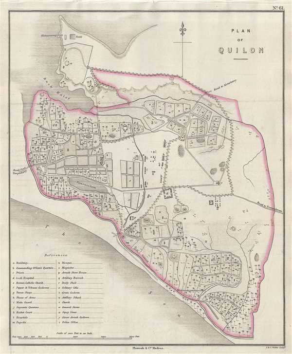
Plan of Quilon.
sold
- Digital Map Information
- Suitable for large format printing
- DPI: 300
- File Size: 3.61 MB
- File Type: ZIP / TIFF
- ICC color profile embedded
- Delivered instantly via download link
This is a lovely 1854 Pharoah and Company map of the old seaport and city of Kollam or Quilon on the coast of Kerala, India. It covers the city in beautiful detail, noting streets, lagoons, important buildings, fields and topography. A reference table in the lower ... (more details)
An iconic pictorial map of San Diego.

The California Pacific International Exposition. San Diego.
sold
- Digital Map Information
- Suitable for large format printing
- File Size: 20.89 MB
- File Type: ZIP / TIFF
- ICC color profile embedded
- Delivered instantly via download link
An attractive 1935 pictorial map of San Diego, California, drawn by Don Bloodgood. This map was sponsored by Shell Oil and drawn to celebrate the 1935 California Pacific Exposition. Looking eastward from a location high above this Pacific, this map covers San ... (more details)
Only known example of the official 1927 plan to dredge the Hai River in order to turn Tianjin into a modern shipping port.
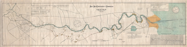
Hai Ho Conservancy Commission. Plan of Hai-Ho from Tientsin City to the Sea. January 1927.
sold
- Digital Map Information
- Suitable for large format printing
- File Size: 33.63 MB
- File Type: ZIP / TIFF
- ICC color profile embedded
- Delivered instantly via download link
An extremely rare and important 1927 map by Poul E. Müller and the Hai Ho Conservancy Commission illustrating the course of the Hai River between Tianjin and the Bohai Sea. The map illustrates official plan and work of the Commission in expanding, dredging, ... (more details)
A unusual variant state of Ernest Dudley Chase's map of the British Isles. Signed by Chase in the lower left, just under the copyright.
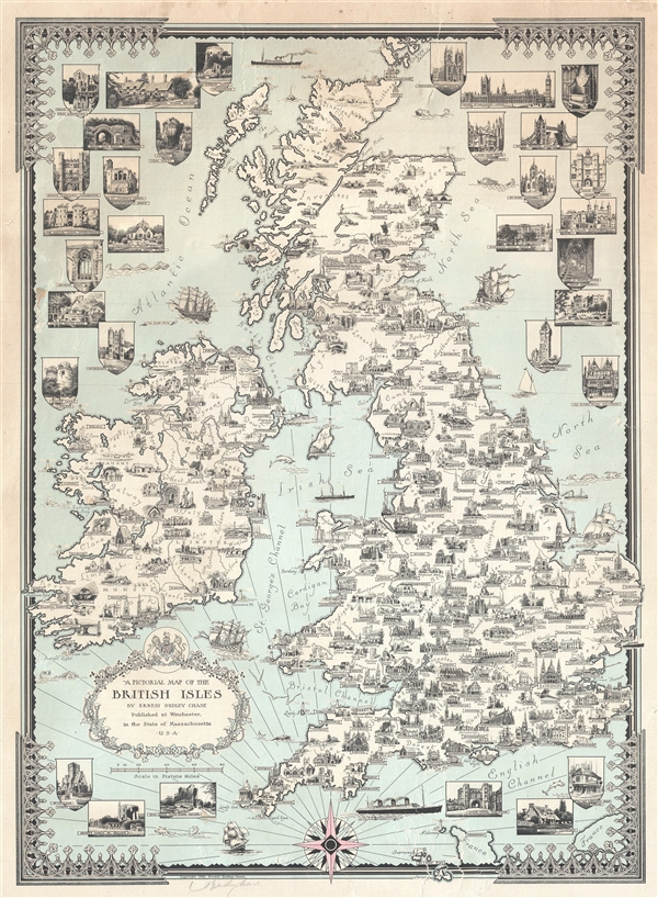
A Pictorial Map of the British Isles By Ernest Dudley Chase.
sold
- Digital Map Information
- Suitable for large format printing
- File Size: 13.26 MB
- File Type: ZIP / TIFF
- ICC color profile embedded
- Delivered instantly via download link
An uncommon signed 1935 pictorial map of the British Isles by Ernest Dudley Chase. The map covers all of England, Scotland, Wales, and Ireland. Chase uses the most important building in each town, usually a church or lordly manor, to symbolize the whole. ... (more details)
Rare map of Maryland and Delaware from the 2nd earliest American Atlas published.
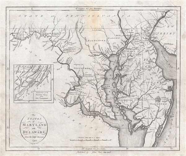
States of Maryland and Delaware from the latest Surveys. 1795.
sold
- Digital Map Information
- Suitable for large format printing
- DPI: 300
- File Size: 9.56 MB
- File Type: ZIP / TIFF
- ICC color profile embedded
- Delivered instantly via download link
An important map of Maryland and Delaware issued by John Reid in 1796. This map is from Reid's American Atlas , only the second atlas to be published in America. The map details the Chesapeake Bay Region from Fort Cumberland on the Potomac River to the ... (more details)
Fascinating map. One of the earliest obtainable maps of Kentucky and Tennessee.
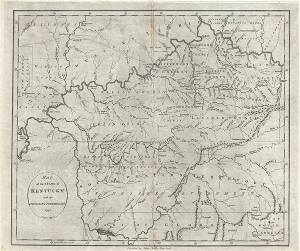
Map of the State of Kentucky; with the Adjoining Territories. 1795.
sold
- Digital Map Information
- Suitable for large format printing
- DPI: 300
- File Size: 8.93 MB
- File Type: ZIP / TIFF
- ICC color profile embedded
- Delivered instantly via download link
This 1795 map by John Reid is one of the earliest obtainable maps of Kentucky and Tennessee. Centered on the Cumberland River, the map covers from New Madrid on the Mississippi River to, roughly, the Cumberland Gap, and from the confluence of the Ohio ... (more details)
Plan of the Battle of Yorktown drawn from a French eye-witness account.

Plan D'York en Virginie avec les attaques et les Campemens de l'Armee combinee de France et d'Amerique. [Battle of Yorktown]
sold
- Digital Map Information
- Suitable for large format printing
- DPI: 300
- File Size: 5.89 MB
- File Type: ZIP / TIFF
- ICC color profile embedded
- Delivered instantly via download link
An important 1787 American Revolutionary War map illustrating the Battle of Yorktown, the last major conflict of the war. The map centers on the battleground just south of Yorktown on the shores of the York River. Gloucester is apparent just across ... (more details)
One of the earliest obtainable maps of Bombay or Mumbai, India.

Plan De Bombay et de Ses Environs.
sold
- Digital Map Information
- Suitable for large format printing
- Full resolution TIFF file
- ICC color profile embedded
- Delivered instantly via download link
This beautifully hand colored c. 1750 Jacques Nicolas Bellin map of Bombay (Mumbai), India. Bellin's map illustrates Bombay as it was becoming the British East India Company's primary base of operations in India, replacing Surat to the north in ... (more details)
Identifies the Sea of Korea.
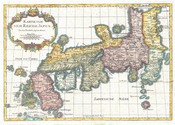
Karte Von Dem Reiche Japon.
sold
- Digital Map Information
- Suitable for large format printing
- DPI: 300
- File Size: 3.19 MB
- File Type: ZIP / TIFF
- ICC color profile embedded
- Delivered instantly via download link
This is a beautiful 1752 Bellin map of the empire of Japan. Centered on the Bay of Osaka, this map covers from Hirado (here identified as I. Firando) and Nagasaki to Akita (Aquita), to include most of Tokugawa (edo) era Japan. The island of ... (more details)
Pictorial map drawn to promote tourism and settlement of the Utah Valley.
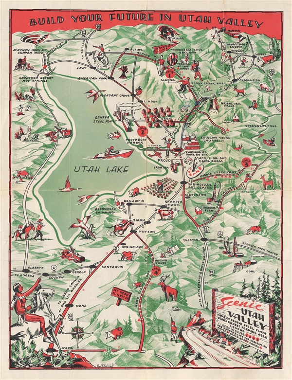
Scenic Utah Valley. Home of Geneva Steel Plant. Utah's Richest Framing Area.
sold
- Digital Map Information
- Suitable for large format printing
- File Size: 12.93 MB
- File Type: ZIP / TIFF
- ICC color profile embedded
- Delivered instantly via download link
An attractive c. 1947 pictorial map of the Utah Valley by Floyd Emil Breinholt. The map covers Utah Lake and the regions south as far as Nephi, and east as far as Strawberry Lake. The map was drawn to promote tourism and development in the ... (more details)
Unusual panoramic view of the Panama Canal.

Bird's Eye View of the Panama Canal & Map of Panama.
sold
- Digital Map Information
- Suitable for large format printing
- File Size: 11.97 MB
- File Type: ZIP / TIFF
- ICC color profile embedded
- Delivered instantly via download link
A very attractive c. 1915 bird's-eye view and map of the Panama Canal by I. L. Maduro of Panama. The sheet is divided into three sections: a profile view of the canal, a bird's-eye view of the canal, and a smaller map of Panama. The large ... (more details)
Curious pictorial map showing New York City and the United States as percieved by a New Yorker.

New York.
sold
An uncommon pictorial map most likely dating from the early 1970s. This map follows in the model of 'The New Yorker's Idea of the United States of America' established by Daniel K. Wallingford in the 1930s. Under Wallingford's paradigm, ... (more details)
Unusal historical map of Paris.
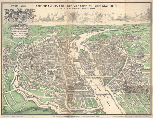
Paris en 1630. / Agenda-Buvard des Magasins du Bon Marche. / Le Plan de la Ville, Cite, Universite, Fauxbourgs de Paris…
sold
- Digital Map Information
- Suitable for large format printing
- File Size: 18.96 MB
- File Type: ZIP / TIFF
- ICC color profile embedded
- Delivered instantly via download link
An attractive late 19th century illustration of Paris, France as it may have appeared in 1630. Most likely issued around 1899, this map presents 17th century Paris as seen looking West form a position high above the Seine River. ... (more details)
A very unusual map focusing on Flushing Bay and the East River as it flows between Queens and the Bronx.
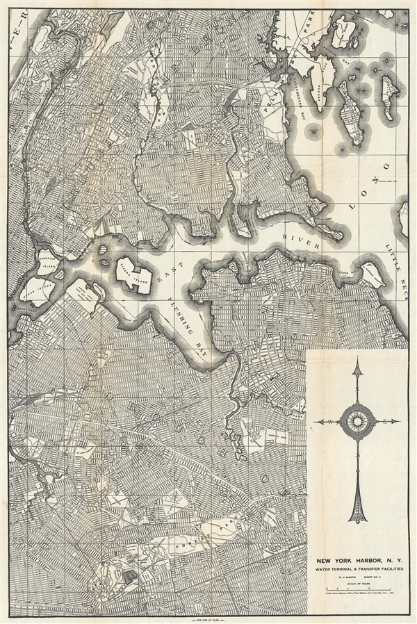
New York Harbor, N.Y. Water Terminal and Transfer Facilities.
sold
- Digital Map Information
- Suitable for large format printing
- File Size: 18.28 MB
- File Type: ZIP / TIFF
- ICC color profile embedded
- Delivered instantly via download link
An uncommon 1920 map detailing the South Bronx and Flushing, in Northern Queens, New York City. Issued by the U.S. Engineer Office, this map focuses on The East River as it flows past Hell Hate and Rikers Island towards Flushing Bay ... (more details)
Exceptionally rare 1755 map of Norway and Sweden. Only one copy in the OCLC.

Carte de Norwége & 1e. de Suéde.
sold
- Digital Map Information
- Suitable for large format printing
- DPI: 300
- File Size: 12.34 MB
- File Type: ZIP / TIFF
- ICC color profile embedded
- Delivered instantly via download link
A 1755 map of Scandinavia of considerable rarity by Jean Palairet and John Gibson. Map covers Norway and Sweden from the high Arctic to the Baltic Sea and from the Atlantic Ocean to Finland. There is little topography except for a ... (more details)
A remarkable heavily annotated wall format map of the world showing Texas as a Republic.
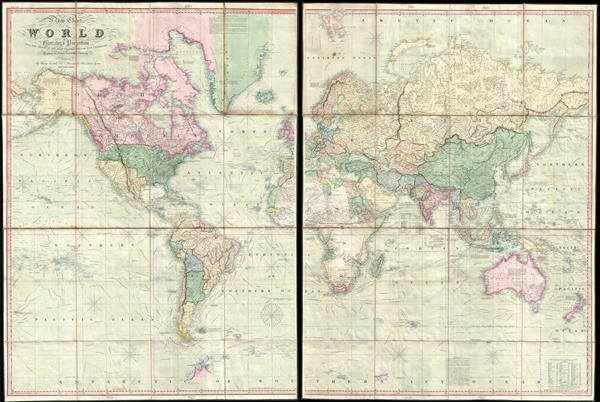
A New Chart of the World On Mercator's Projection With The Tracks Of The Most Celebrated and Recent Navigators.
sold
- Digital Map Information
- Suitable for large format printing
- DPI: 300
- File Size: 81.91 MB
- File Type: ZIP / TIFF
- ICC color profile embedded
- Delivered instantly via download link
This is an impressive 1845 large format map of the world by Henry Teesdale. The map covers the entire world on a Mercator projection with copious notes and annotations throughout. It is significant for many reasons, but chief among them is that it is one of the few English maps to recognize the Republic of Texas (as England itself did not) - and depict its most ambitious boundary configuration. It is also the first map to show a complete northwest passage following the Deese-Simpson Expedition. The map is thorough, including the most up to date political events and discoveries, but also tends to be biased, although not always towards Anglo-centric interests. For example, the map agrees with British claims to British Columbia relating to the 54/40 Oregon Question, and ignores the discoveries of Charles Wilkes (1798 - 1877) and the U.S. Exploring Expedition (1838 - 1842), no doubt to bolster the competing exploratory claims of Englishman John Ross (1777 - 1856). Teesdale's map is beautifully presented in two sections, each of which have been dissected into sixteen panels and laid on linen. The whole folds into a beautifully tooled leather binder with marbled endpapers. (more details)
Important French and Indian War issue of Bellin's influential Map of the Great Lakes. Probably the most decorative of the series.
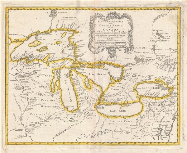
Partie Occidentale de la Nouvelle France ou du Canada.
sold
- Digital Map Information
- Suitable for large format printing
- DPI: 300
- File Size: 11.3 MB
- File Type: ZIP / TIFF
- ICC color profile embedded
- Delivered instantly via download link
A rare and extremely influential 1755 map of the Great Lakes drawn by Jacques Nicholas Bellin. This map, which appeared in the 1755 issue of the Homann Heirs Atlas Major , depicts all five of the Great Lakes as well as the adjacent ... (more details)
Rare Yiddish Map of Israel, one of only 2 known examples.
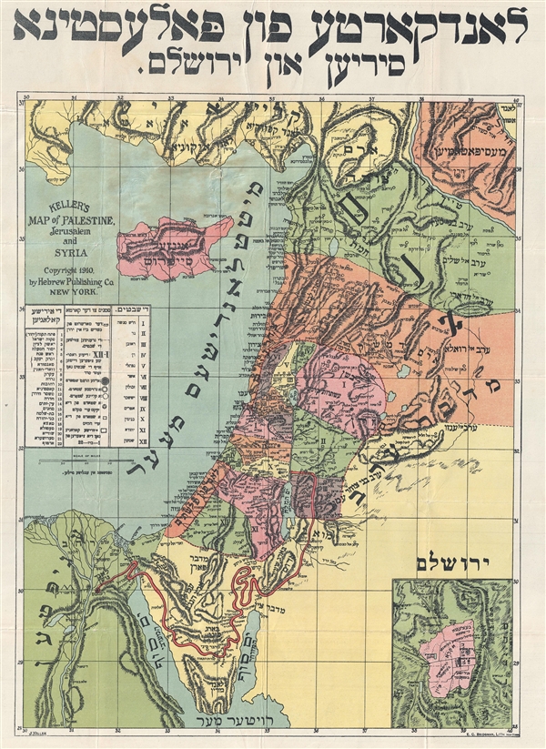
Keller's Map of Palestine, Jerusalem and Syria / לאנדקארטע פון פאלעסטינא סיריען און ירושלם
sold
- Digital Map Information
- Suitable for large format printing
- File Size: 9.95 MB
- File Type: ZIP / TIFF
- ICC color profile embedded
- Delivered instantly via download link
This is a rare 1910 Yiddish / Hebrew language map of Israel (Palestine / Holy Land) by J. Keller. The map covers roughly from Turkey to the top of the Sinai Peninsula and from the Nile Delta to Damascus. There is an inset of ... (more details)
Very rare map illustrating the areas damaged by the Great Boston Fire of 1872.

Map of Boson and its Vicinity. Prepared for distribution at the convention of the American Society of Civil Engineers, Boston, June 1878.
sold
- Digital Map Information
- Suitable for large format printing
- File Size: 18.82 MB
- File Type: ZIP / TIFF
- ICC color profile embedded
- Delivered instantly via download link
A rare 1878 map of Boston and its vicinity illustrating the district burnt by the Great Boston Fire of November 90-10, 1872. Centered on Boston State House, this map covers from West Cambridge to Hangmans's Island and from ... (more details)
Uncommon persuasive map illustrating the global progress of Christian evangelization.
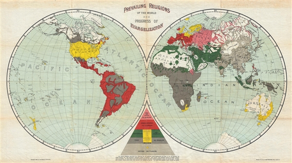
Prevailing Religions of the World and Progress of Evangelization.
sold
- Digital Map Information
- Suitable for large format printing
- File Size: 8.71 MB
- File Type: ZIP / TIFF
- ICC color profile embedded
- Delivered instantly via download link
A curious 1894 map of the world that attempts to map the religious deportment and the progress of evangelization. The map, which is printed on waxed linen, uses bold printed color to identify various religious groups: ... (more details)