
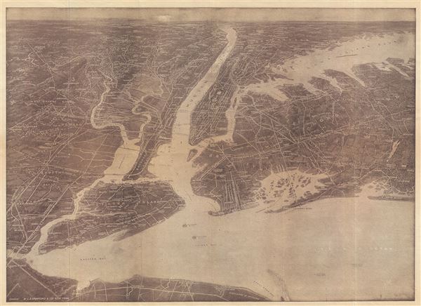
Hammond's Birds Eye View Map of New York City and Vicinity showing Roads, Railroads, Cities and Towns, etc.
sold
- Digital Map Information
- Suitable for large format printing
- Full resolution TIFF file
- ICC color profile embedded
- Delivered instantly via download link
This is an exceptionally scarce 1925 chromolithograph C. S. Hammond and Company map and view of New York City and vicinity. The view extends from Raritan Bay north to Croton Point and east as far as Huntington, covering all of Manhattan, Brooklyn, Queens, the ... (more details)

Colton's New York City, Brooklyn, Jersey City, Hoboken, etc.
sold
- Digital Map Information
- Suitable for large format printing
- Full resolution TIFF file
- ICC color profile embedded
- Delivered instantly via download link
This is an extremely rare example of G. Woolworth Colton's 1883 vertical pocket map of New York. This important map, first issued in 1865, marks a significant rethinking of the standard Manhattan map. Previous maps of New York City tended to represent only ... (more details)

Narragansett Bay.
sold
- Digital Map Information
- Suitable for large format printing
- Full resolution TIFF file
- ICC color profile embedded
- Delivered instantly via download link
This is an attractive and uncommon c. 1900 bird's eye view map of Narragansett Bay, Rhode Island, by the Boston map publisher George H. Walker. The view covers the entirety of Narragansett Bay from Point Judith to Providence, and extending eastwards as far ... (more details)

New Map of Boston Giving All Points of Interest : With Every Railway and Steamboat Terminus, Prominent Hotels Theatres and Public Buildings.
sold
- Digital Map Information
- Suitable for large format printing
- Full resolution TIFF file
- ICC color profile embedded
- Delivered instantly via download link
This is a beautiful 1883 map or plan of the city of Boston, Massachusetts by Geo H. Walker and Company. It covers the city of Boston from Charlestown and Somerville to Marine Park and Old Harbor. Individual streets, important buildings, neighborhoods, ... (more details)
Curious map with tantalizing hints of Australia.
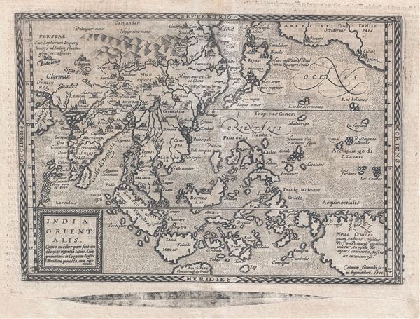
India Orientalis. cuius nobilior pars sunt duo ista quasi ingentia totius Asiæ promontaria in Oceanum versus Meridiem projecta, cum suis insulis.
sold
- Digital Map Information
- Suitable for large format printing
- DPI: 300
- File Size: 5.24 MB
- File Type: ZIP / TIFF
- ICC color profile embedded
- Delivered instantly via download link
An attractive and scarce 1600 map of the East Indies by Johann Bussemacher and Matthias Quad. Cartographically derived from Ortelius' slightly earlier map of the same region, this map covers from Arabia east to the Americas and New Guinea and from ... (more details)

Johnson's Roman Empire, Imperius Romanorum Latissime Patens.
sold
- Digital Map Information
- Suitable for large format printing
- File Size: 12.51 MB
- File Type: ZIP / TIFF
- ICC color profile embedded
- Delivered instantly via download link
This is an attractive example of Johnson and Ward's 1862 map of the Roman Empire. Covers all of Europe as well as much of the Middle East, Persia and parts of North Africa. Presents the Roman Empire following the Punic Wars, when it reached at its ... (more details)
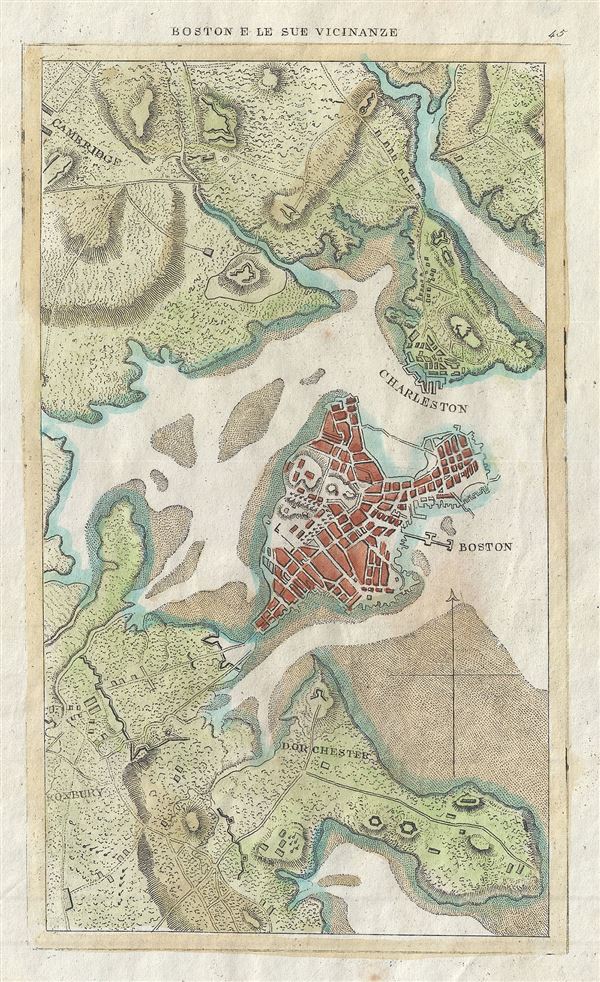
Boston e le Sue Vicinanze.
sold
- Digital Map Information
- Suitable for large format printing
- Full resolution TIFF file
- ICC color profile embedded
- Delivered instantly via download link
This is a beautiful c.1830 map or plan of Boston, Massachusetts. It covers the city of Boston from Cambridge to Roxbury. Beautifully rendered in stupendous detail, it notes tows, forts, roads, buildings and topography. Identifies Roxbury, ... (more details)
The hypothetical Muller Peninsula.

Bowles's New Pocket Map of the Discoveries made by the Russians on the North West Coast of America Published by the Royal Academy of Sciences at Petersburg.
sold
- Digital Map Information
- Suitable for large format printing
- Full resolution TIFF file
- ICC color profile embedded
- Delivered instantly via download link
An attractive example of Carrington Bowles' 1780 map of the North Pacific, including parts of Alaska, the Pacific Northwest, and Northeast Asia. Coverage extends from the Arctic Circle south to the latitudes of Vancouver and Japan. Most dramatically, the map includes a large speculative pre-Cook peninsula extending westward from North America towards Asia. This is generally known as the Muller Peninsula after Gerhard Muller, who hypothesized it in 1754. The map is also notable for its unusual Bulbous promontory in northern Siberia, an interpretation of the Witsen Peninsula, which is a mismapping of the Chukchi Peninsula. (more details)
One of the earliest obtainable plains of Sydney, Australia.

Plan von Sydney der Hauptstadt der Englischen Colonien in Australien. Aufgenommen von Hrn. Lesueur; und berichtigt von Hrn Boullanger i. J. 1802
sold
- Digital Map Information
- Suitable for large format printing
- DPI: 300
- File Size: 2.91 MB
- File Type: ZIP / TIFF
- ICC color profile embedded
- Delivered instantly via download link
One of the earliest obtainable maps of the city of Sydney, Australia, this is an 1808 German edition of an 1802 manuscript Map by Charles-Alexandre Lesueur's. The map covers from Darling Harbour to Dawes Batter and from Woolloomooloo to ... (more details)

Nantucket Island.
sold
- Digital Map Information
- Suitable for large format printing
- Full resolution TIFF file
- ICC color profile embedded
- Delivered instantly via download link
This is a charming c.1946 pictorial map of Nantucket Island by L. Parker. This beautiful tourist map covers Nantucket Island including the smaller Tuckernuck and Muskeget Islands. An inset on Nantucket Town in included in the top left ... (more details)
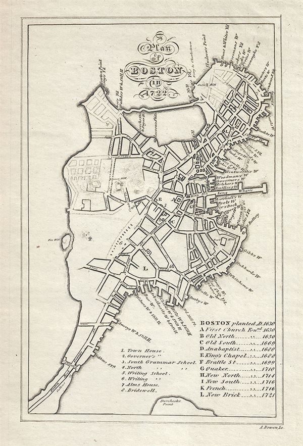
A Plan of Boston in 1722.
sold
- Digital Map Information
- Suitable for large format printing
- Full resolution TIFF file
- ICC color profile embedded
- Delivered instantly via download link
This is a rare c.1820 map or plan of Boston in 1722 by Abel Bowen. It covers the city of Boston as it existed in 1722 from North End to Dorchester Point. Beautifully rendered in stupendous detail, it notes individual streets, wharfs, ... (more details)
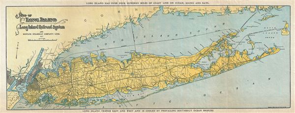
Map of Long Island showing the Long Island Railroad System and Montauk Steamboat Company Lines.
sold
- Digital Map Information
- Suitable for large format printing
- Full resolution TIFF file
- ICC color profile embedded
- Delivered instantly via download link
This appealing map of Long Island was issued in 1911 by the Long Island Railroad. It depicts Long Island in full inclusive of Manhattan, Brooklyn, Queens, the Long Island Sound, and the southern shore of Connecticut and northern parts ... (more details)
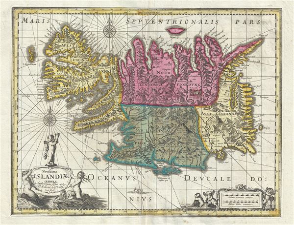
Novissima Islandiae Tabula.
sold
- Digital Map Information
- Suitable for large format printing
- Full resolution TIFF file
- ICC color profile embedded
- Delivered instantly via download link
This is a beautiful c.1680 map of Iceland by Gerard Valk and Pieter Schenk. It covers the entire north Atlantic Island of Iceland and notes the four primary provinces in color. Iceland had been fairly well mapped since the late 16th ... (more details)
One of Lotter's most iconic maps.

Pensylvania Nova Jersey et Nova York cum Regionibus Ad Fluvium Delaware In America Sitis, Nova Delinatione ob oculos posita . . .
sold
- Digital Map Information
- Suitable for large format printing
- DPI: 300
- File Size: 24.1 MB
- File Type: ZIP / TIFF
- ICC color profile embedded
- Delivered instantly via download link
A fine c. 1756 example of one of Tobias Conrad Lotter's most iconic maps. This is Lotter's important map of the Middle Atlantic and New England regions during the British colonial period. One of the most desirable, interesting and ... (more details)
Spectacular Dutch world map with iconic allegorical border work by Nicolaes Berchem.
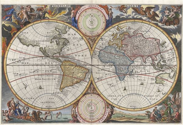
Werreldt Kaert
sold
- Digital Map Information
- Suitable for large format printing
- DPI: 300
- File Size: 11.42 MB
- File Type: ZIP / TIFF
- ICC color profile embedded
- Delivered instantly via download link
A fine 1682 world map was drawn by Nicolaas Visscher for publication in the 1682 edition of the Keur Bible. Based on Visscher's very similar map of 1658, this map depicts the world on a hemisphere projection surrounded by stunning ... (more details)
Unusual elongated map of Manhattan Island.
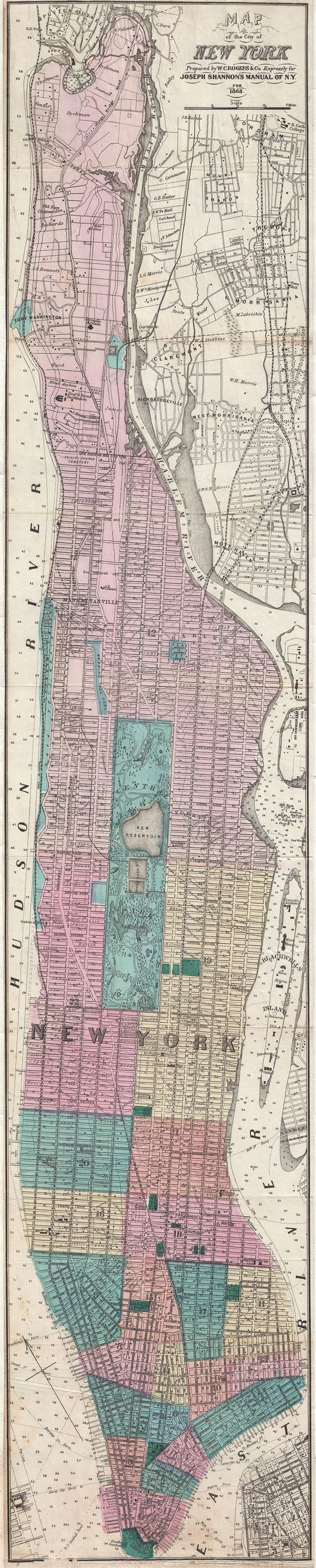
Map of the City of New York.
sold
- Digital Map Information
- Suitable for large format printing
- File Size: 12.06 MB
- File Type: ZIP / TIFF
- ICC color profile embedded
- Delivered instantly via download link
An unusual and very rare 1868 Map of New York city by W. C. Rogers. Map covers the whole of the island of Manhattan with some detail in parts of Brooklyn, Queens and the Bronx. This unusual map offers extraordinary detail ... (more details)
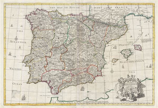
A correct map of Spain and Portugal : according to the newest observations and discoveries communicated to the Royal Society at London and the Royal Academy at Paris…
sold
- Digital Map Information
- Suitable for large format printing
- DPI: 300
- File Size: 40.04 MB
- File Type: ZIP / TIFF
- ICC color profile embedded
- Delivered instantly via download link
An exception c. 1708 elephant folio (large format) map of Spain and Portugal by the English cartographer John Senex. This enormously proportioned map covers the entirety Iberia from the Atlantic Coast to Minorca and from ... (more details)
The first, largest, and finest star maps of the 19th century.

[Cetus Monstrum Marinum]
sold
- Digital Map Information
- Suitable for large format printing
- DPI: 300
- File Size: 33.29 MB
- File Type: ZIP / TIFF
- ICC color profile embedded
- Delivered instantly via download link
A rare and extraordinary 1801 Johann Elbert Bode elephant folio celestial, constellation, or star map of Cetus (the Sea Monster) or as it is more commonly known, the Whale. Cetus was originally been associated with a ... (more details)

West Indies.
sold
- Digital Map Information
- Suitable for large format printing
- File Size: 8.28 MB
- File Type: ZIP / TIFF
- ICC color profile embedded
- Delivered instantly via download link
This is an excellent 1855 example of Colton's map of the West Indies. Like most of Colton's North America maps, this map was derived from an earlier wall map of North America produced by Colton and D. Griffing ... (more details)
The first, largest, and finest star maps of the 19th century.
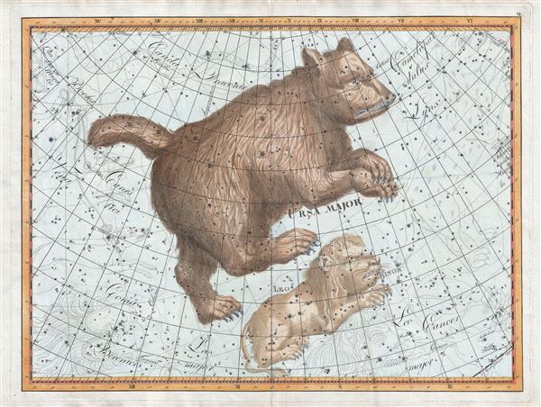
Ursa Major.
sold
- Digital Map Information
- Suitable for large format printing
- Full resolution TIFF file
- ICC color profile embedded
- Delivered instantly via download link
A rare and extraordinary 1801 Johann Elbert Bode elephant folio celestial, constellation, or star map of Ursa Major (the Great Bear or Big Dipper) and Leo Minor. Considered the largest and most dramatic ... (more details)