
Scarce early map of Asia offering a speculative Hokkaido.
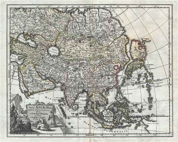
Nova Asiae Tabula e majori in minorem hanc formam reducta a Ioh. Bapt. Homann excudente Christophero Weigelio Noribergae.
sold
- Digital Map Information
- Suitable for large format printing
- DPI: 300
- File Size: 8.07 MB
- File Type: ZIP / TIFF
- ICC color profile embedded
- Delivered instantly via download link
A scarce 1719 Christopher Weigel and J. B. Homann map of Asia. Based upon an earlier map of J. B. Homan, this Weigel reduction covers all of Asia from the Black Sea to Japan and from Nova Zembla to New Guinea. There is an elaborate allegorical title cartouche ... (more details)

Boston Bay and Approaches Massachusetts.
sold
- Digital Map Information
- Suitable for large format printing
- Full resolution TIFF file
- ICC color profile embedded
- Delivered instantly via download link
This is a large 1905 U.S. Coast and Geodetic Survey nautical chart or maritime map of Boston Bay, Massachusetts and its approaches. It covers the Massachusetts coastline from Marshfield north past Cohasset, Weymouth, Quincy, Boston, Lynn, Marblehead, Salem and ... (more details)
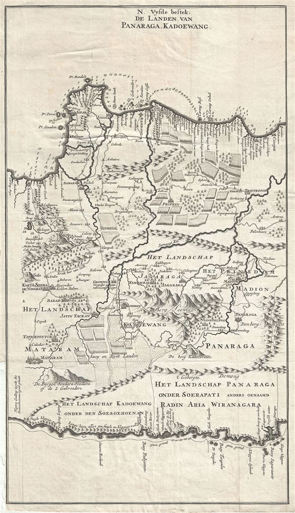
N. Vysde bestek, De Landen van Panaraga, Kadoewang.
sold
- Digital Map Information
- Suitable for large format printing
- Full resolution TIFF file
- ICC color profile embedded
- Delivered instantly via download link
This is a rare and exquisite 1726 map of central Java by Francois Valentijn. It covers from modern day Semarang (Samarang) east to Tuban (Toeban). The important cities of Madiun (Madion), Ponorogo (Panaraga) and others are noted. The map offers beautiful ... (more details)

Cheap Ward with its Division into Parishes according to a new Survey.
sold
- Digital Map Information
- Suitable for large format printing
- Full resolution TIFF file
- ICC color profile embedded
- Delivered instantly via download link
This is a beautiful map of the Cheap Ward in London, England by Benjamin Cole. The map covers Cheap (from the Old English word meaning 'market') Ward in the City of London from Milk Street east to Prince's Street and from Guildhall south as far as Queen ... (more details)
Scarce pocket map of Chicago.
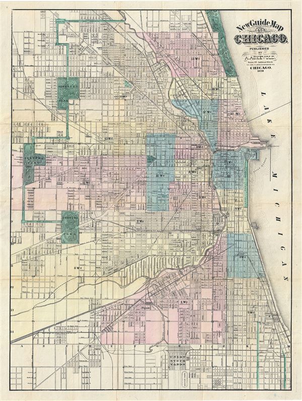
New Guide Map of Chicago. Abraham Lincoln Presidential Library, GZ896 C53 (1875) A834.
sold
- Digital Map Information
- Suitable for large format printing
- File Size: 21.78 MB
- File Type: ZIP / TIFF
- ICC color profile embedded
- Delivered instantly via download link
An extremely rare 1876 pocket map of Chicago, Illinois by the Anders M. Askevold. This Chicago published map covers from Central Park in the west to Lack Michigan in the east, and from Lincoln Park in the north to Union Stock Yards in the south. City ... (more details)
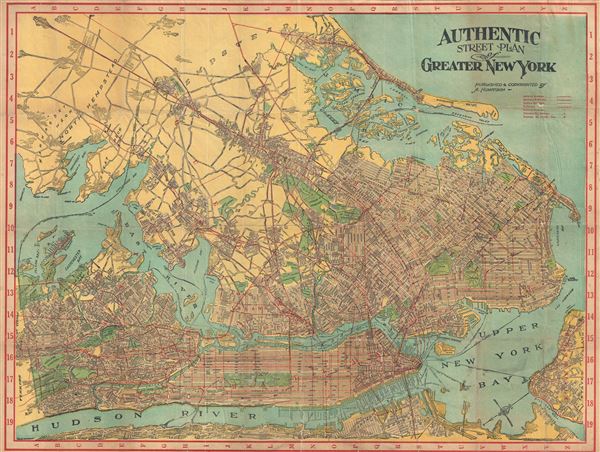
Authentic Street Plan of Greater New York.
sold
- Digital Map Information
- Suitable for large format printing
- File Size: 270.74 MB
- File Type: ZIP / TIFF
- ICC color profile embedded
- Delivered instantly via download link
This is a beautiful c.1910 map of New York City and vicinity by A. Humitsch. It covers the greater New York area from Yonkers south to the Kill Van Kull and from Weehawken to Hempstead and includes the boroughs of Manhattan, Bronx, Brooklyn, Queens and ... (more details)
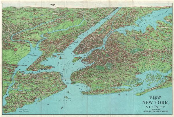
View of New York and Vicinity Showing Good Automobile Roads.
sold
- Digital Map Information
- Suitable for large format printing
- File Size: 23.26 MB
- File Type: ZIP / TIFF
- ICC color profile embedded
- Delivered instantly via download link
This is an exceptional c.1929 birds-eye view map of New York City and vicinity by George J. Nostrand. Presented in chromolithograph color, this view reveals the five New York City Boroughs of Manhattan, Brooklyn, Queens, Staten Island and the Bronx. ... (more details)

Map of Taipei.
sold
- Digital Map Information
- Suitable for large format printing
- Full resolution TIFF file
- ICC color profile embedded
- Delivered instantly via download link
This is an unusual 1958 bi-lingual tourist map of Taipei City, Taiwan (Formosa). The map covers Taipei City in great detail, noting streets, rivers, parks, railways and public areas. An inset detailing Taipei Suburbs is included in the lower left ... (more details)
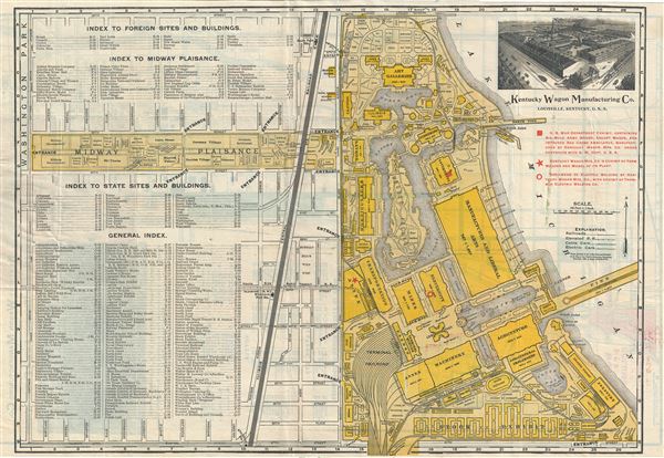
Indexed Guide Map and key to World's Fair Buildings, Grounds and Exhibits.
sold
This is a scarce map prepared in 1893 by Rand McNally and Co. for the Chicago World's Fair or, as it is better known, the 1893 Columbian Exposition. The map is printed on both sides. The primary side shows the grounds of the Columbian Exposition, ... (more details)
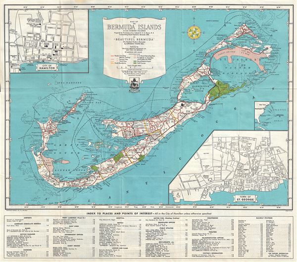
Map of The Bermuda Islands Alias Somers Islands.
sold
- Digital Map Information
- Suitable for large format printing
- Full resolution TIFF file
- ICC color profile embedded
- Delivered instantly via download link
This is a beautiful 1945 map of the Bermuda Islands by Euphemia Young Bell. It covers the Bermuda or the Somers Islands in exquisite detail, noting roads, surrounding islands and reefs, towns, golf courses, churches, U.S. Bases, airports, ... (more details)
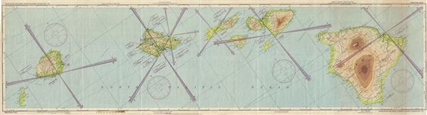
Hawaiian Islands, North Pacific Ocean No. 170.
sold
- Digital Map Information
- Suitable for large format printing
- Full resolution TIFF file
- ICC color profile embedded
- Delivered instantly via download link
This is an uncommon 1945 World War II era U.S. Army Air Forces aeronautical chart or map of the Hawaiian Islands in the North Pacific Ocean. It covers the entire archipelago and includes the Hawaiian Islands of Niihau, Kauai, Oahu, ... (more details)
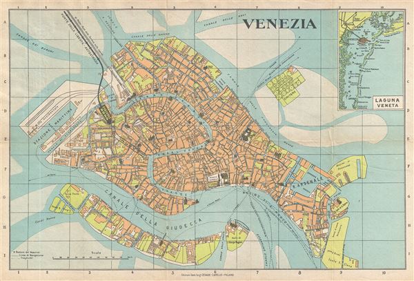
Venezia.
sold
- Digital Map Information
- Suitable for large format printing
- Full resolution TIFF file
- ICC color profile embedded
- Delivered instantly via download link
This is a beautiful c.1950 map or city plan of Venice, Italy by Cesare Capello. It covers Venice from Canale Scomenzera to Isola San Pierto and Bacini di Raddobbo and from Isola Della Giudecca to Canal Delle Sacche in the north. ... (more details)
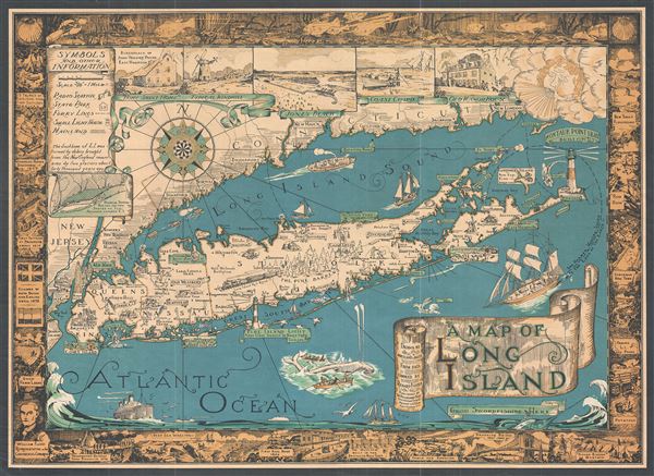
A Map of Long Island.
sold
- Digital Map Information
- Suitable for large format printing
- Full resolution TIFF file
- ICC color profile embedded
- Delivered instantly via download link
This is a charming 1933 first edition pictorial map of Long Island by Courtland Smith. This historical map covers from New London in Connecticut and Fishers Island south as far as the Lower New York Bay and Staten Island. Long ... (more details)
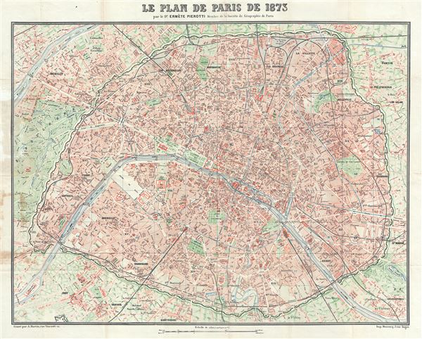
Le Plan de Paris de 1873.
sold
- Digital Map Information
- Suitable for large format printing
- Full resolution TIFF file
- ICC color profile embedded
- Delivered instantly via download link
This is an attractive 1873 map or plan of the city of Paris, France by Dr. Ermete Pierotti. Centered on the Seine, the map covers the embastilled Paris as contained by the Thiers Wall, as well as its immediate vicinity, ... (more details)
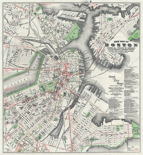
New Map of Boston Giving All Points of Interest : With Every Railway and Steamboat Terminus, Prominent Hotels Theatres and Public Buildings.
sold
- Digital Map Information
- Suitable for large format printing
- Full resolution TIFF file
- ICC color profile embedded
- Delivered instantly via download link
This is a beautiful 1905 map or plan of the city of Boston, Massachusetts by the Walker Lithograph and Publishing Company. It covers the city of Boston from Charlestown and Somerville to Marine Park and Old Harbor. ... (more details)

Trolley Wayfinder Birds Eye View of Trolley Routes in New England.
sold
- Digital Map Information
- Suitable for large format printing
- Full resolution TIFF file
- ICC color profile embedded
- Delivered instantly via download link
A scarce and stunning bird's eye view style pocket map of New England issued in 1905 by George Walker published by the New England Street Railway Club. The view reveals New England, centered on Boston, extending north as far as Lewistown, Brunswick and Yarmouth; south to Narragansett Bay, Newport and New Bedford; and west as far as Worcester. Train and trolley routes throughout the region are illustrated, with myriad towns and villages labeled throughout the region. Both electric railroads and steam railroads are noted here, with red lines indicating an electric railroad and a black line marking the route of a steam railroad. Various parks, lighthouses, historic sites, and geographical features are also labeled. Popular routes are highlighted by inset maps, which include: Springfield-Turners Falls, Worcester-Springfield, Springfield-New York City, Pittsfield and Vicinity, Rochester-Nashua, Portsmouth-Lewiston, and a triangle route from Worchester to Providence to New London and back. An inset of the vicinity of Boston is situated in the upper left corner. (more details)

India.
sold
- Digital Map Information
- Suitable for large format printing
- Full resolution TIFF file
- ICC color profile embedded
- Delivered instantly via download link
This is an extremely rare Thai language map of India and part of Southeast Asia including India, China, Thailand, Laos, Malay, Singapore, Vietnam, Myanmar (Burma), Afghanistan, Pakistan and Cambodia. It covers from ... (more details)

Thailand.
sold
- Digital Map Information
- Suitable for large format printing
- Full resolution TIFF file
- ICC color profile embedded
- Delivered instantly via download link
This is an extremely rare Thai language map of Southeast Asia featuring Thailand, Laos, Malay, Singapore, Vietnam and Cambodia. It covers from the Guangdong province in China, including Hainan and Macao, south to ... (more details)
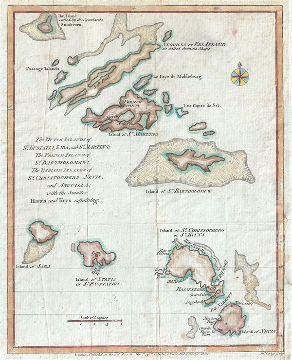
The Dutch Islands of St. Eustatia, Saba, and St. Martins; The French Island of St. Bartholomew; The English Islands of St. Christophers, Nevis, and Anguilla; with the smaller Islands and Keys adjoining.
sold
- Digital Map Information
- Suitable for large format printing
- Full resolution TIFF file
- ICC color profile embedded
- Delivered instantly via download link
This is a scarce 1781 John Lodge map of the Leeward Islands or the northern islands of the Lesser Antilles chain in West Indies. It covers from Hat Island (Sombrero) south as far as Nevis and depicts the colonial ... (more details)

Colton's Township Map of the state of New Jersey.
sold
- Digital Map Information
- Suitable for large format printing
- Full resolution TIFF file
- ICC color profile embedded
- Delivered instantly via download link
This is Colton's exquisite hand colored and highly detailed 1871 pocket map of New Jersey. It depicts the whole of the state and surrounding areas in splendid detail with particular attention to roads, cities, ... (more details)