
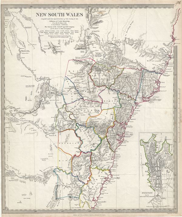
New South Wales.
sold
- Digital Map Information
- Suitable for large format printing
- DPI: 300
- File Size: 6.18 MB
- File Type: ZIP / TIFF
- ICC color profile embedded
- Delivered instantly via download link
This is a fascinating 1833 map of New South Wales, Australia, by the S.D.U.K. It covers the eastern Australia from Trial Bay to Bateman Bay. Although the coastlines are accurately mapped, much of the interior remains relatively unknown. Several notes throughout ... (more details)
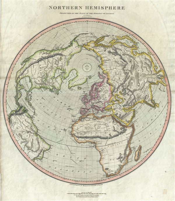
Northern Hemisphere.
sold
- Digital Map Information
- Suitable for large format printing
- DPI: 300
- File Size: 14.96 MB
- File Type: ZIP / TIFF
- ICC color profile embedded
- Delivered instantly via download link
This is a beautiful hand colored 1816 map by Edinburgh cartographer John Thomson depicting the Northern Hemisphere projected on the plane of the horizon of London. It covers all of North America, Europe, Asia and Africa as well as the northern parts of South ... (more details)

Northern Hemisphere.
sold
- Digital Map Information
- Suitable for large format printing
- DPI: 300
- File Size: 16.9 MB
- File Type: ZIP / TIFF
- ICC color profile embedded
- Delivered instantly via download link
This fascinating hand colored 1814 map by Edinburgh cartographer John Thomson depicts the Northern Hemisphere from the Arctic to the Equator. Includes all of North America, Europe, and Asia as well as the northern part of Africa and South America. ... (more details)
Identifies the Sea of Korea.
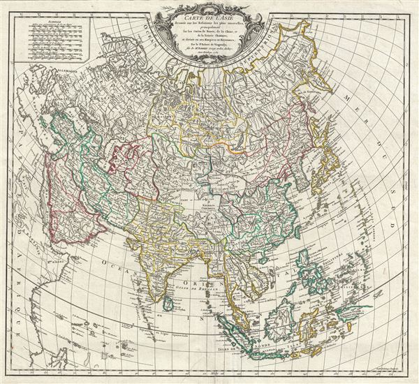
Carte de l'Asie dressee sur les Relations les plus nouvelles, principalement fur les Cartes de Russie, de la Chine, et de la Tatarie Chinoise; et divisee en ses Empires et Royaumes.
sold
- Digital Map Information
- Suitable for large format printing
- DPI: 300
- File Size: 14.57 MB
- File Type: ZIP / TIFF
- ICC color profile embedded
- Delivered instantly via download link
A rare and attractive 1750 map of Asia by Robert de Vaugondy. Vaugondy's map covers the entire continent from Africa and the Mediterranean east to the Bering Sea and south as far as Java and New Guinea. This map is most interesting in its ... (more details)
One of the earliest printed maps to offer significant detail of the Lower Mississippi Valley.
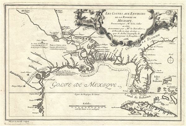
Les Costes Aus Environs de la Riviere de Misisipi.
sold
- Digital Map Information
- Suitable for large format printing
- DPI: 300
- File Size: 3.88 MB
- File Type: ZIP / TIFF
- ICC color profile embedded
- Delivered instantly via download link
An uncommon map of often neglected and misunderstood significance, this is Nicolas de Fer's 1705 map of the Gulf Coast, Florida, and Texas. This is one of the earliest published maps to show any significant detail of the lower Mississippi ... (more details)
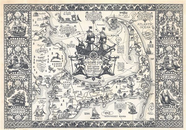
The Map of Old Cape Cod The Land of Bold explorers Heroic Pilgrims Hardy seamen Great fisheries and Famous ships.
sold
- Digital Map Information
- Suitable for large format printing
- File Size: 16.3 MB
- File Type: ZIP / TIFF
- ICC color profile embedded
- Delivered instantly via download link
This is a beautiful example of the 1930 pictorial map of Cape Cod, Massachusetts drawn by artist Frederick Coulton Waugh. It covers all of Cape Cod as well as part of the adjacent South Shore including Plymouth, Buzzard Bay, and Duxbury. ... (more details)
Scarce separate issue map of Boston.
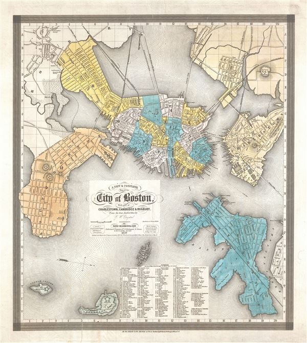
A New and Complete Map of the City of Boston, with part of Charleston, Cambridge and Roxbury.
sold
- Digital Map Information
- Suitable for large format printing
- DPI: 300
- File Size: 12.17 MB
- File Type: ZIP / TIFF
- ICC color profile embedded
- Delivered instantly via download link
A separately issued 1839 map of Boston offered in its scarce first edition. This very uncommon map was compiled by George Washington Boynton for the Boston publisher Nathaniel Dearborn. Presented with an unusual westward orientation, ... (more details)
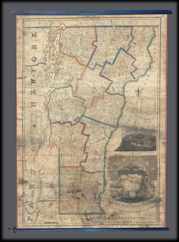
Vermont from Actual Survey with all the Late Additions and Improvements.
sold
- Digital Map Information
- Suitable for large format printing
- DPI: 300
- File Size: 57.97 MB
- File Type: ZIP / TIFF
- ICC color profile embedded
- Delivered instantly via download link
This is a large 1821 wall map of Vermont by James Whitelaw, Esq. It covers the state of Vermont in its entirety along with parts of its neighboring states. The map notes Rivers, roads, mountains and a host of additional topographical ... (more details)
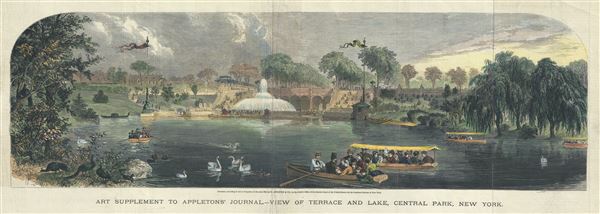
Art Supplement to Appleton's Journal, View of Terrace and Lake, Central Park, New York.
sold
- Digital Map Information
- Suitable for large format printing
- File Size: 10.74 MB
- File Type: ZIP / TIFF
- ICC color profile embedded
- Delivered instantly via download link
This is a charming 1869 view of the Bethesda Terrace and Lake in Central Park, issued by D. Appleton. The Bethesda Terrace is located roughly at 72nd streets in the heart of New York City's Central Park. The view beautifully depicts ... (more details)

Dominii Veneti cum vicinis Parmae Mutinae Mantuae et Mirandol.
sold
- Digital Map Information
- Suitable for large format printing
- DPI: 300
- File Size: 18.59 MB
- File Type: ZIP / TIFF
- ICC color profile embedded
- Delivered instantly via download link
This is a beautiful c.1745 Homann Heirs map of northeast Italy. It covers from Bermago east as far as Albona (Labin) and from Vipiteno Sterzing south as far as Florence. The map is exceptionally detailed, noting towns, rivers, ... (more details)

Mappa Geographica Status Genuensis.
sold
- Digital Map Information
- Suitable for large format printing
- DPI: 300
- File Size: 14.77 MB
- File Type: ZIP / TIFF
- ICC color profile embedded
- Delivered instantly via download link
This is a beautifully detailed 1749 Homann Heirs map of the Republic of Genoa (modern day Liguria), Italy. It covers the north-western part of Italy from Monaco to Massa. The map is exceptionally detailed, noting towns, ... (more details)
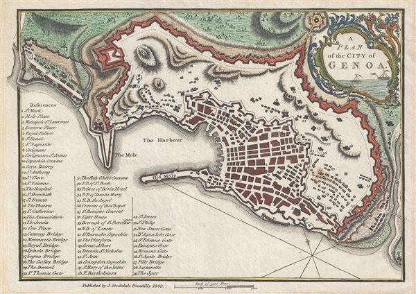
A Plan of the City of Genoa.
sold
- Digital Map Information
- Suitable for large format printing
- DPI: 300
- File Size: 2.82 MB
- File Type: ZIP / TIFF
- ICC color profile embedded
- Delivered instantly via download link
This is an appealing 1800 map or city plan of Genoa, Italy, issued by John Stockdale. It beautifully depicts the coastal city and the capital of Liguria located in north western Italy. The map is exceptionally detailed, ... (more details)

La France.
sold
- Digital Map Information
- Suitable for large format printing
- File Size: 4.17 MB
- File Type: ZIP / TIFF
- ICC color profile embedded
- Delivered instantly via download link
This is a beautiful 1893 Vuillemin map of the French department of Gironde. This coastal department is the seat of the Bordeaux wine region and produces many of the world's finest reds. Shows numerous vineyards and ... (more details)

Dept. de la Gironde.
sold
- Digital Map Information
- Suitable for large format printing
- File Size: 9.76 MB
- File Type: ZIP / TIFF
- ICC color profile embedded
- Delivered instantly via download link
This is a fascinating 1861 map of the French department of Gironde. This coastal department is the seat of the Bordeaux wine region and produces many of the world's finest reds. Shows numerous vineyards and ... (more details)
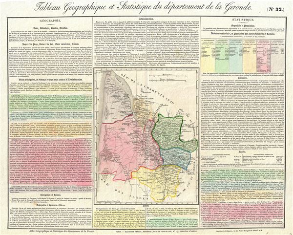
Tableau Geographique et Statistique du departement de la Gironde.
sold
- Digital Map Information
- Suitable for large format printing
- DPI: 300
- File Size: 10.78 MB
- File Type: ZIP / TIFF
- ICC color profile embedded
- Delivered instantly via download link
This is a fascinating 1826 map of the French department of Gironde by the Baldwin Brothers. This coastal department is the seat of the Bordeaux wine region and produces many of the world's finest reds. ... (more details)

Dept. de la Gironde.
sold
- Digital Map Information
- Suitable for large format printing
- DPI: 300
- File Size: 8.13 MB
- File Type: ZIP / TIFF
- ICC color profile embedded
- Delivered instantly via download link
This is a fascinating 1851 map of the French department of Gironde. This coastal department is the seat of the Bordeaux wine region and produces many of the world's finest reds. Shows numerous ... (more details)
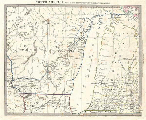
North America Sheet V The North West and Michigan Territories.
sold
- Digital Map Information
- Suitable for large format printing
- DPI: 300
- File Size: 5.9 MB
- File Type: ZIP / TIFF
- ICC color profile embedded
- Delivered instantly via download link
This is a scarce and important map issued by the S.D.U.K. in 1833 depicting Lake Michigan, the second largest of the five Great Lakes, and the only one that lies entirely within the United ... (more details)

Dept. de la Gironde.
sold
- Digital Map Information
- Suitable for large format printing
- DPI: 300
- File Size: 9.28 MB
- File Type: ZIP / TIFF
- ICC color profile embedded
- Delivered instantly via download link
This is a fascinating 1852 map of the French department of Gironde. This coastal department is the seat of the Bordeaux wine region and produces many of the world's finest reds. Shows ... (more details)
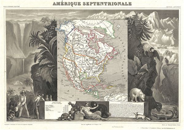
Amerique Septentrionale.
sold
- Digital Map Information
- Suitable for large format printing
- DPI: 300
- File Size: 9.7 MB
- File Type: ZIP / TIFF
- ICC color profile embedded
- Delivered instantly via download link
A visually stunning decorative map of North America dating to 1852, by French map publisher Victor Levasseur. Levasseur published several different editions of his North America map - ... (more details)
Scarce map showing Australian Gold Discoveries.
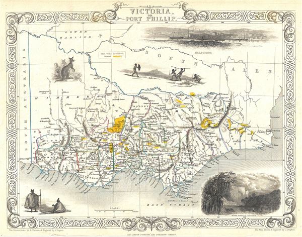
Victoria or Port Phillip.
sold
- Digital Map Information
- Suitable for large format printing
- DPI: 300
- File Size: 4.21 MB
- File Type: ZIP / TIFF
- ICC color profile embedded
- Delivered instantly via download link
This is a scarce 1851 map of Victoria or Port Phillip, Australia by John Tallis. The map covers Victoria from Discovery Bay east past Melbourne to Mallacoota (Mallagoota). It also ... (more details)