
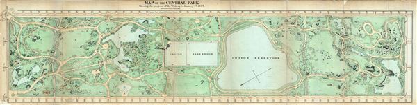
Map of the Central Park Showing the progress of the Work on January 1st 1867.
sold
- Digital Map Information
- Suitable for large format printing
- File Size: 11.33 MB
- File Type: ZIP / TIFF
- ICC color profile embedded
- Delivered instantly via download link
An altogether extraordinary hand colored map of New York City's Central Park prepared and printed for inclusion in the Tenth Annual Report of the Board of Commissioners of the Central Park . This extremely rare variant on the map of Central Park originally ... (more details)
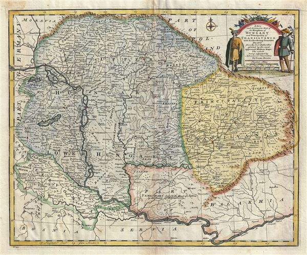
A New and Accurate Map of the Kingdom of Hungary and Principality of Transilvania with the Bordering Countries.
sold
- Digital Map Information
- Suitable for large format printing
- DPI: 300
- File Size: 10.18 MB
- File Type: ZIP / TIFF
- ICC color profile embedded
- Delivered instantly via download link
An attractive 1747 map of Hungary and Transylvania (part of modern day Romania) by the British cartographer Emanuel Bowen. The map covers the region from the Carpathian Mountains south as far as the Danube River, including parts of modern day Hungary, ... (more details)
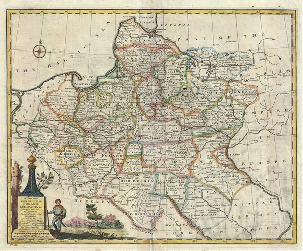
A New and Accurate Map of Poland, Lithuania etc. Divided into its Palatinats.
sold
- Digital Map Information
- Suitable for large format printing
- DPI: 300
- File Size: 9.87 MB
- File Type: ZIP / TIFF
- ICC color profile embedded
- Delivered instantly via download link
This is a beautiful 1747 map of Poland and Lithuania by the British cartographer Emanuel Bowen. It depicts the different Palatinates or administrative divisions of Poland and Lithuania as well as parts of Germany, the Russian Empire, Hungary, ... (more details)
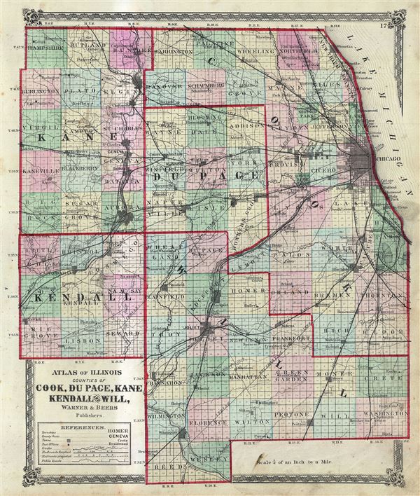
Atlas of Illinois Counties of Cook, Du Page, Kane Kendall and Will.
sold
- Digital Map Information
- Suitable for large format printing
- File Size: 6.63 MB
- File Type: ZIP / TIFF
- ICC color profile embedded
- Delivered instantly via download link
This is a scarce hand colored map of the counties of Cook, Du Page, Kane, Kendall and Will of the state of Illinois issued by Warner and Beers. Depicts the counties in the northern part of the state of Illinois in great detail, noting towns, ... (more details)
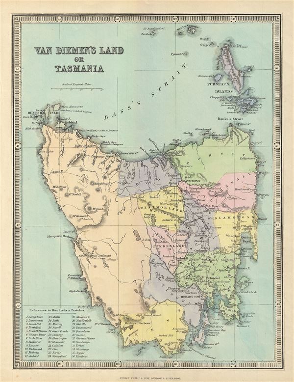
Van Diemen's Land or Tasmania.
sold
- Digital Map Information
- Suitable for large format printing
- File Size: 3.98 MB
- File Type: ZIP / TIFF
- ICC color profile embedded
- Delivered instantly via download link
This is a beautiful 1857 map of Van Diemen's Land or Tasmania issued by George Philip and Sons. The map covers the entire island of Tasmania in considerable detail noting lakes, mountains, rivers, towns, parishes and other topographical ... (more details)
Identifies the Sea of Korea.
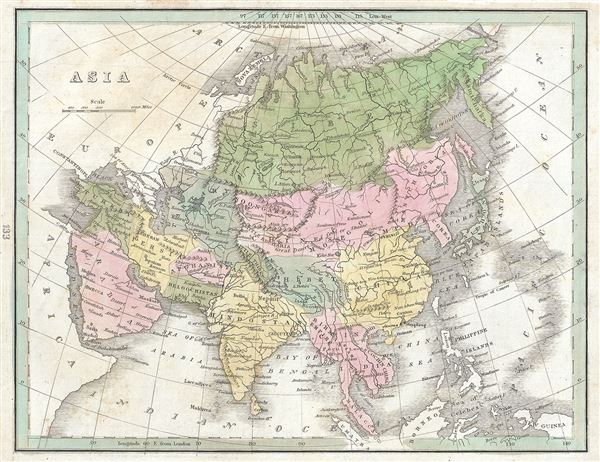
Asia.
sold
- Digital Map Information
- Suitable for large format printing
- DPI: 300
- File Size: 3.85 MB
- File Type: ZIP / TIFF
- ICC color profile embedded
- Delivered instantly via download link
This fine 1835 map of Asia was printed by the important American mapmaker T. G. Bradford. The map covers the entire Asian continent from the Arctic Ocean to the Indian Ocean and from the Red Sea to the New Guinea. Towns, rivers, ... (more details)

North America Sheet V The North West and Michigan Territories. North America Parts of Wisconsin and Michigan. Sheet V.
sold
- Digital Map Information
- Suitable for large format printing
- DPI: 300
- File Size: 13.13 MB
- File Type: ZIP / TIFF
- ICC color profile embedded
- Delivered instantly via download link
A scarce and important set of 2 maps issued by the S.D.U.K. in 1833 and 1848 depict Lake Michigan, the second largest of the five Great Lakes, and the only one that lies entirely within the United States. This pair of maps, ... (more details)
Depicts insular Korea and is the first map to show the discoveries of Vries and Coen.
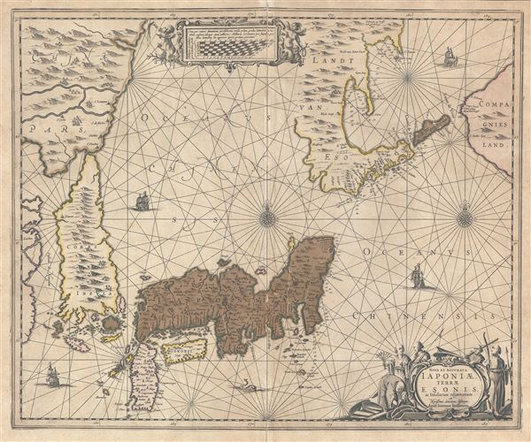
Nova et Accurata Japoniae Terrae Esonis ac Insularum adjacentium.
sold
- Digital Map Information
- Suitable for large format printing
- DPI: 300
- File Size: 18.31 MB
- File Type: ZIP / TIFF
- ICC color profile embedded
- Delivered instantly via download link
An attractive old color first state example of Johannes Janssonius 1658 map of Japan and the surrounding lands, including an exceptional insular Korea. Centered on Japan's largest island, Honshu, this map covers from ... (more details)
The Swan Song of Speculative Cartography regarding the Pacific Northwest.
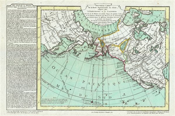
Nouvelle Carte de la Partie Septentrionale du Globe, comprise entre le Kamtchatka et la Californie.
sold
- Digital Map Information
- Suitable for large format printing
- DPI: 300
- File Size: 7.68 MB
- File Type: ZIP / TIFF
- ICC color profile embedded
- Delivered instantly via download link
Truly one of the scarcest and most extraordinary maps we have ever seen, this is Jean-Nicholas Buache de Neuville's 1781 map of the North Pacific, North America, and Siberia. This map is so dense with cartographic ... (more details)
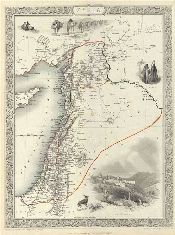
Syria.
sold
- Digital Map Information
- Suitable for large format printing
- DPI: 300
- File Size: 5.67 MB
- File Type: ZIP / TIFF
- ICC color profile embedded
- Delivered instantly via download link
This is an appealing example of John Tallis and John Rapkin's 1851 map of Syria. It covers from the Gulf of Iskenderun to the Dead Sea and includes the modern day Syria, Lebanon, Israel and parts of Jordan and ... (more details)

Part of South Australia.
sold
- Digital Map Information
- Suitable for large format printing
- DPI: 300
- File Size: 5.28 MB
- File Type: ZIP / TIFF
- ICC color profile embedded
- Delivered instantly via download link
This is a beautiful example of John Tallis and John Rapkin's 1851 map of South Australia, Australia. Centered on the Spencer Gulf, it covers the southeastern part of the state of South Australia from Lake ... (more details)
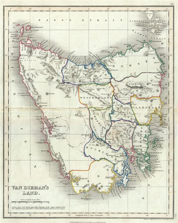
Van Dieman's Land.
sold
- Digital Map Information
- Suitable for large format printing
- Full resolution TIFF file
- ICC color profile embedded
- Delivered instantly via download link
This is a beautiful 1860 map of Van Diemen's Land or Tasmania, issued by John Dower. The map covers the entire island of Tasmania in considerable detail noting towns, lakes, mountain ranges and other ... (more details)
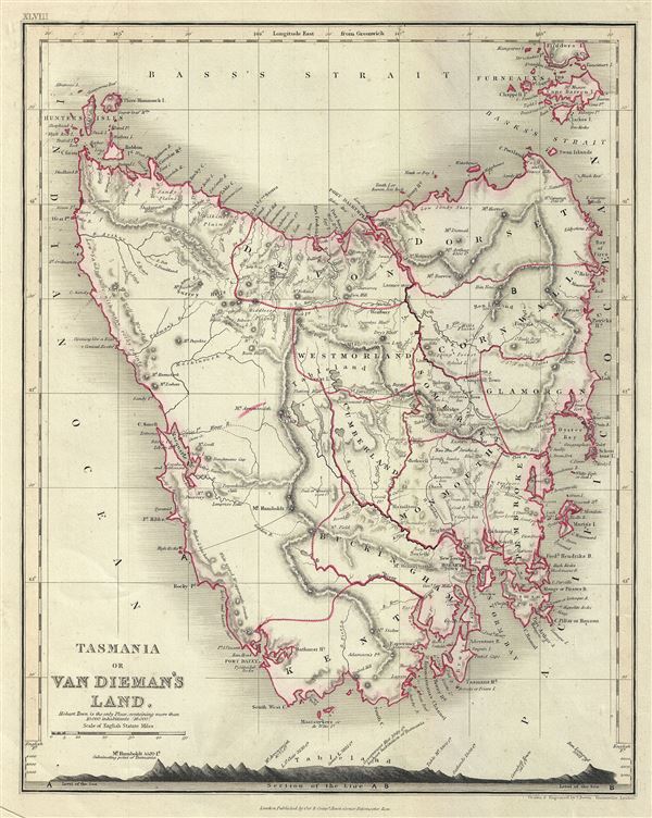
Tasmania or Van Dieman's Land.
sold
- Digital Map Information
- Suitable for large format printing
- Full resolution TIFF file
- ICC color profile embedded
- Delivered instantly via download link
A fine 1860 map of Tasmania or Van Diemen's Land by John Dower. The map covers the entire island of Tasmania in considerable detail noting towns, lakes, mountain ranges and other topographical ... (more details)

Van Diemen's Island or Tasmania.
sold
- Digital Map Information
- Suitable for large format printing
- DPI: 300
- File Size: 5.47 MB
- File Type: ZIP / TIFF
- ICC color profile embedded
- Delivered instantly via download link
An impressive 1851 Tallis map of Van Diemen's Island or Tasmania. The map covers the entire island of Tasmania in considerable detail noting towns, lakes, mountain ranges and other ... (more details)

North America Sheet IV Lake Superior.
sold
- Digital Map Information
- Suitable for large format printing
- DPI: 300
- File Size: 6.06 MB
- File Type: ZIP / TIFF
- ICC color profile embedded
- Delivered instantly via download link
A fine 1848 full color edition of the S.D.U.K. map of Lake Superior, the largest of the five Great Lakes. The map covers from Nagagami Lake (Nagagaminga Lake) south as far the ... (more details)
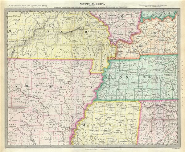
North America Sheet X Parts of Missouri, Illinois, Kentucky, Tennessee, Alabama, Mississippi and Arkansas.
sold
- Digital Map Information
- Suitable for large format printing
- DPI: 300
- File Size: 7.83 MB
- File Type: ZIP / TIFF
- ICC color profile embedded
- Delivered instantly via download link
An attractive 1848 full color edition of the S.D.U.K. map of Arkansas, Missouri, Mississippi, Kentucky, Tennessee, Alabama and Illinois. The map covers from St. Clair in ... (more details)
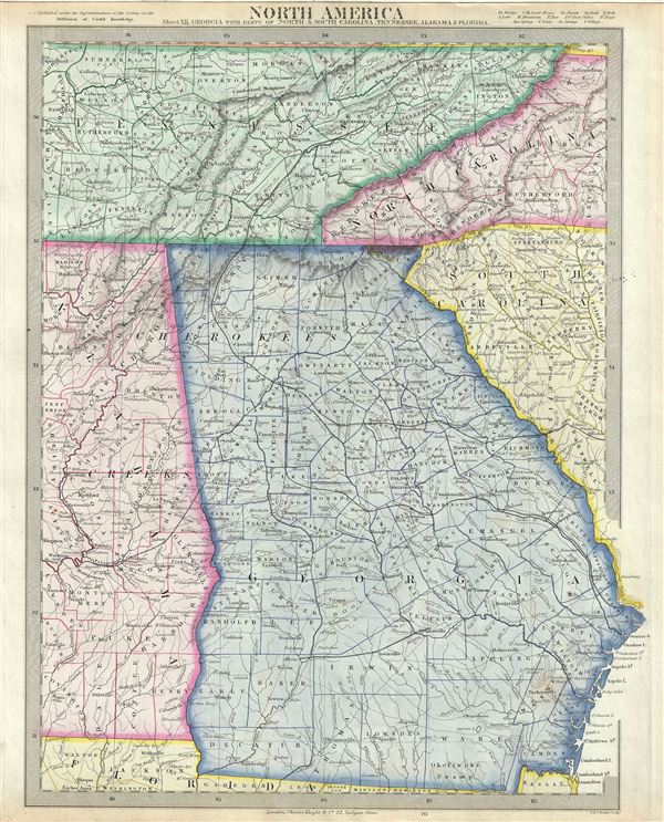
North America Sheet XII. Georgia, with Parts of North and South Carolina, Tennessee, Alabama and Florida.
sold
- Digital Map Information
- Suitable for large format printing
- DPI: 300
- File Size: 8.36 MB
- File Type: ZIP / TIFF
- ICC color profile embedded
- Delivered instantly via download link
A beautiful 1848 full color map of Tennessee, Georgia and parts of Alabama, North Carolina and South Carolina issued by the S.D.U.K. It covers the states of Tennessee ... (more details)
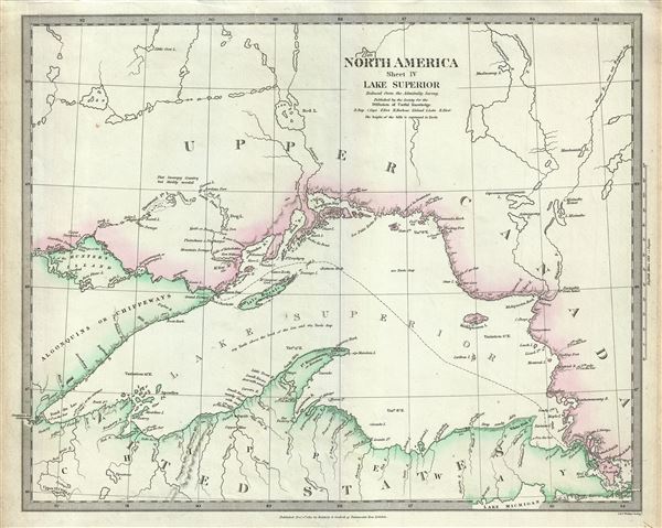
North America Sheet IV Lake Superior.
sold
- Digital Map Information
- Suitable for large format printing
- DPI: 300
- File Size: 6.55 MB
- File Type: ZIP / TIFF
- ICC color profile embedded
- Delivered instantly via download link
A beautiful 1832 S.D.U.K. map of Lake Superior, the largest of the five Great Lakes. Centered on Lake Superior, the map coves the modern day regions of southern ... (more details)
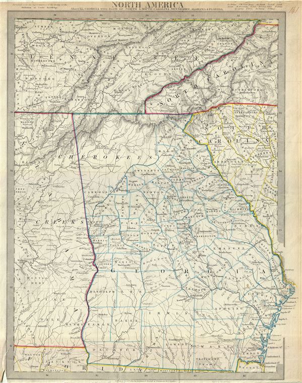
North America Sheet XII. Georgia, with Parts of North and South Carolina, Tennessee, Alabama and Florida.
sold
- Digital Map Information
- Suitable for large format printing
- DPI: 300
- File Size: 8.39 MB
- File Type: ZIP / TIFF
- ICC color profile embedded
- Delivered instantly via download link
This is an uncommon 1833 map of Tennessee, Georgia and parts of Alabama, North Carolina and South Carolina issued by the S.D.U.K. It covers the states of ... (more details)
Scarce map of South Central Africa.
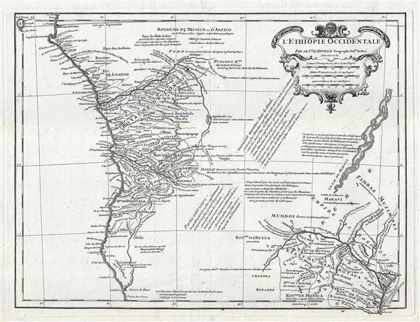
L'Ethiopie Occidentale.
sold
- Digital Map Information
- Suitable for large format printing
- DPI: 300
- File Size: 6.62 MB
- File Type: ZIP / TIFF
- ICC color profile embedded
- Delivered instantly via download link
Scarce map of the Congo, Angola, central Africa, and Monomotapa (Zimbabwe / Malawi) issued in 1732 by Jean-Baptiste Bourguignon d'Anville. D'Anville's ... (more details)