
The only known example of this rare profile of the Hoosac Tunnel.

Profile of Hoosac Mountain, Showing Tunnel.
sold
- Digital Map Information
- Suitable for large format printing
- File Size: 43.7 MB
- File Type: ZIP / TIFF
- ICC color profile embedded
- Delivered instantly via download link
A wonderful and extremely scarce 1878 map or profile view of the Hoosac Mountain, Massachusetts by Edward S. Martin. This profile is a cross section of Hoosac Mountain (also called Hoosic), part of the Berkshires Mountains of Massachusetts. It illustrates the ... (more details)
Later edition of Lewis Evans' map, considered a milestone both for its political significance and expansion of cartographic knowledge.

Carte Generale des Etats de Virginie, Maryland, Delaware, Pensilvanie, Nouveau-Jersey, New-York, Connecticut et Isle de Rhodes Ainsi que des Lacs Erie, Ontario, et Champlain. D'Apres la Carte Ameriquaine de Louis Evans et la Carte Anglaise de Thomas-Jefferys.
sold
- Digital Map Information
- Suitable for large format printing
- DPI: 300
- File Size: 17.66 MB
- File Type: ZIP / TIFF
- ICC color profile embedded
- Delivered instantly via download link
A fine and scarce French edition of Louis Evans' highly influential map of the Middle British Colonies, one of the most important maps of the British Colonies to appear in the 18th century. The map covers Louisville on the Ohio River eastward as far as ... (more details)
Among the earliest American maps to show the United States stretching from coast to coast.
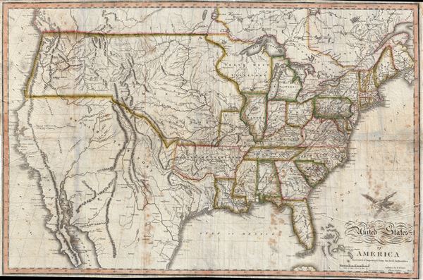
United States of America Corrected and Improved from the Best Authorities
sold
- Digital Map Information
- Suitable for large format printing
- DPI: 300
- File Size: 54.52 MB
- File Type: ZIP / TIFF
- ICC color profile embedded
- Delivered instantly via download link
An exceptional and uncommon 1820 map of the United States issued by Benjamin Warner. Following closely after John Melish's superb wall map of 1819, this is one of the earliest maps to depict the United States extending from Atlantic to Pacific. As Wheat notes, this map is significant as one of several issued up to about 1823 that galvanized geographic ideas regarding the only tenuously explored lands beyond the Rocky Mountains, including the mythical 'River of the West' or 'Buenaventura' and other speculations. (more details)
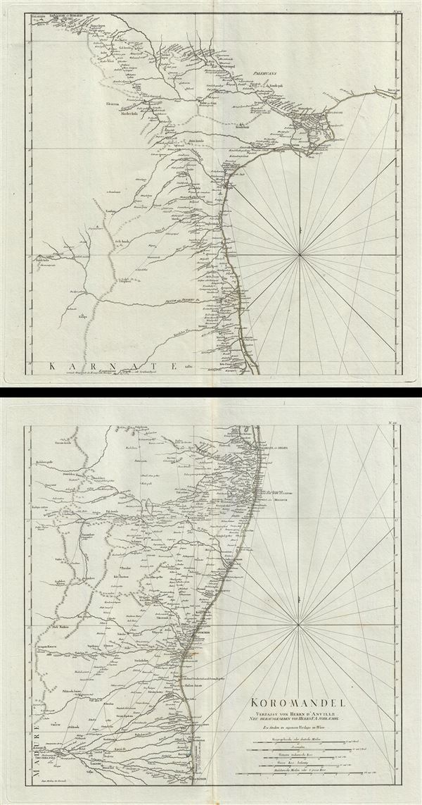
Koromandel.
sold
- Digital Map Information
- Suitable for large format printing
- Full resolution TIFF file
- ICC color profile embedded
- Delivered instantly via download link
This is a monumental and highly detailed map 1789 map of the Coromandel Coast, India by F. A. Schraembl. This map, on two separate sheets, covers the southeastern coast of India from Nagapattinam (Nega-Patnam) north as far as Narsapur and inland as far ... (more details)

Authorized Map of the Second Byrd Antarctica Expedition.
sold
- Digital Map Information
- Suitable for large format printing
- File Size: 18.29 MB
- File Type: ZIP / TIFF
- ICC color profile embedded
- Delivered instantly via download link
This is a fascinating 1934 map of Antarctica issued by the General Food Corporation. It depicts the second Antarctic expedition of Rear Admiral Richard E. Byrd and beautifully illustrates the South Polar Region, including the southern tip of South ... (more details)

Railway and Highway Map of the Famous Berkshire Hills Region, Showing Villages and also Points of Interest.
sold
- Digital Map Information
- Suitable for large format printing
- File Size: 30.15 MB
- File Type: ZIP / TIFF
- ICC color profile embedded
- Delivered instantly via download link
This is a highly desirable 1896 map of the Berkshires or the Berkshire Hills in Massachusetts, by Walter Watson C. E. It covers Berkshire County, located in the western most part of the state of Massachusetts. Parts of the neighboring states of ... (more details)
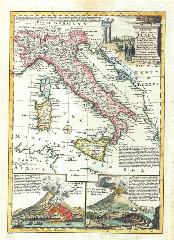
A New and Accurate Map of Italy Drawn from the latest and Best Authorities.
sold
- Digital Map Information
- Suitable for large format printing
- DPI: 300
- File Size: 4.84 MB
- File Type: ZIP / TIFF
- ICC color profile embedded
- Delivered instantly via download link
This is a charming 1747 map of Italy, issued by the British cartographer Emanuel Bowen. It covers all of Italy from the Alps to Malta, including the Islands of Corsica and Sardinia. Several important towns, cities, roads, rivers, and other ... (more details)

A New and Accurate Map of the Kingdoms of Naples and Sicily.
sold
- Digital Map Information
- Suitable for large format printing
- DPI: 300
- File Size: 4.42 MB
- File Type: ZIP / TIFF
- ICC color profile embedded
- Delivered instantly via download link
An attractive 1747 map of southern Italy by the British cartographer Emanuel Bowen. The map covers the Kingdoms of Naples and Sicily in great detail, including part of the Papal States, noting important towns, cities, roads, rivers and ... (more details)
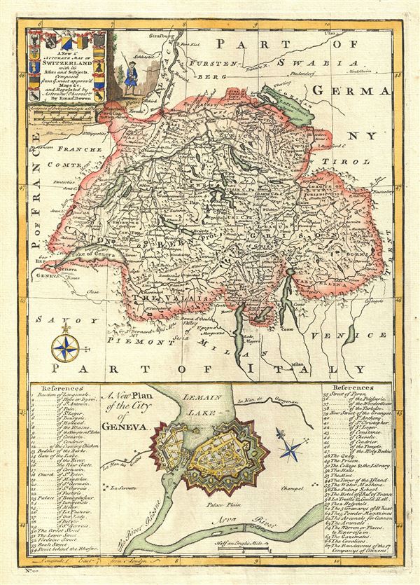
A New and Accurate Map of Switzerland with its Allies and Subjects. A New Plan of the City of Geneva.
sold
- Digital Map Information
- Suitable for large format printing
- DPI: 300
- File Size: 5.34 MB
- File Type: ZIP / TIFF
- ICC color profile embedded
- Delivered instantly via download link
A charming 1747 map of Switzerland by the British cartographer Emanuel Bowen. Essentially two maps on a single sheet, the upper map covers all of Switzerland from Montbeliard in modern day France to Lake Majori. Several important ... (more details)
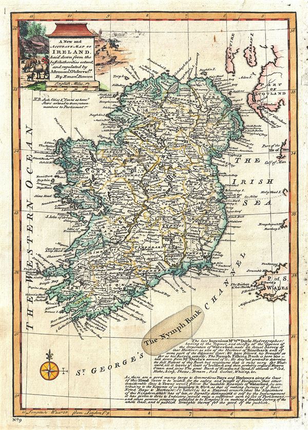
A New and Accurate Map of Ireland.
sold
- Digital Map Information
- Suitable for large format printing
- DPI: 300
- File Size: 4.84 MB
- File Type: ZIP / TIFF
- ICC color profile embedded
- Delivered instantly via download link
This is an appealing 1747 map of Ireland by the British cartographer Emanuel Bowen. The map covers all of Ireland, noting important towns, cities bays, harbors, roads, etc. Forests, mountains are rendered pictorially. The lower ... (more details)
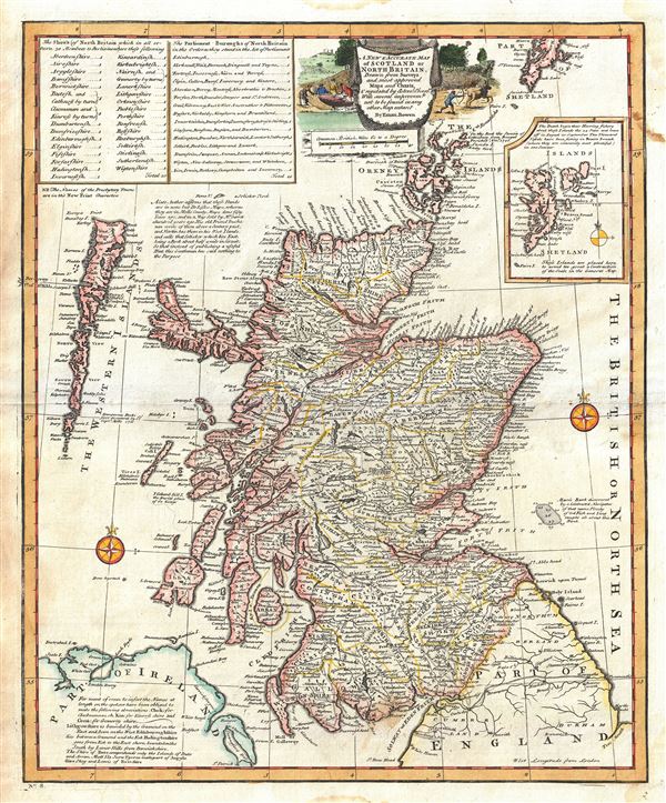
A New and Accurate Map of Scotland or North Britain.
sold
- Digital Map Information
- Suitable for large format printing
- DPI: 300
- File Size: 10.83 MB
- File Type: ZIP / TIFF
- ICC color profile embedded
- Delivered instantly via download link
An attractive 1747 map of Scotland or North Britain, by the British cartographer Emanuel Bowen. It covers Scotland including the Western Islands or the Outer Hebrides and the Orkney Islands. The Shetland Islands are featured in ... (more details)
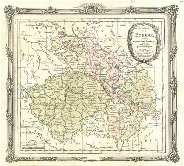
Etats de Boheme, divises en toutes leurs Provinces, tant Civiles qu Ecclesiastiques.
sold
- Digital Map Information
- Suitable for large format printing
- DPI: 300
- File Size: 5.1 MB
- File Type: ZIP / TIFF
- ICC color profile embedded
- Delivered instantly via download link
This is an appealing 1766 of Bohemia or modern day Czech Republic by Brion de la Tour and Louis Charles Desnos. It covers all of modern day Czech Republic and parts of Germany and Poland from Frankfurt in Germany to Linz in ... (more details)
A scarce large format map of East Asia.
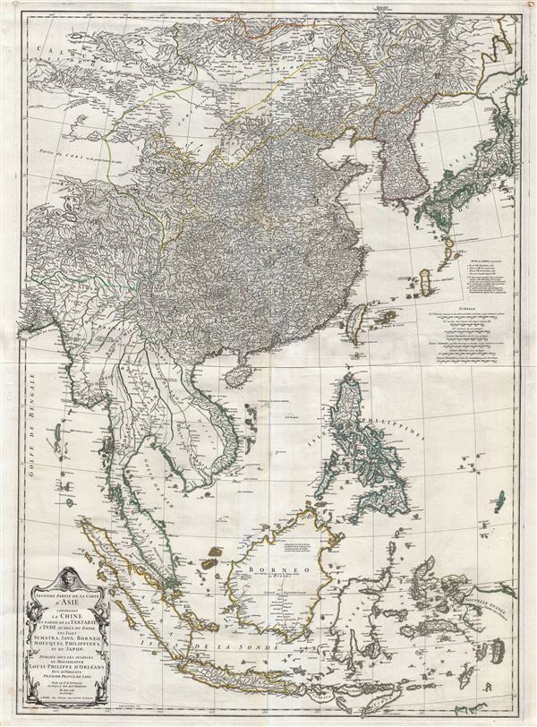
Seconde partie de la Carte d'Asie contenant La Chine et Partie de la Tartarie, L'Inde au de la du Gange, les Isles Sumatra, Java, Borneo, Moluques, Philippines, et du Japon.
sold
- Digital Map Information
- Suitable for large format printing
- Full resolution TIFF file
- ICC color profile embedded
- Delivered instantly via download link
A remarkable and near pristine example of French cartographer Jean Baptiste Bourguignon d'Anville's 1752 map of the East Indies, China Korea and Japan. This impressive map covers from the latitudes of Mongolia and Hokkaido ... (more details)
A foundational map of Persia, Arabia, and India.
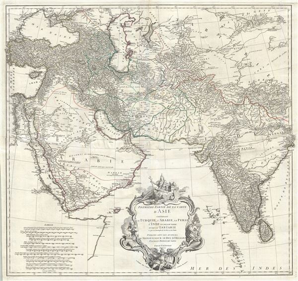
Premiere Partie de la Carte d'Asie contenant La Turquie, L'Arabie, La Perse, L'Inde en deca du Gange et de la Tartarie ce qui est limitrophe de la Perse et de l'Inde.
sold
- Digital Map Information
- Suitable for large format printing
- DPI: 300
- File Size: 36.34 MB
- File Type: ZIP / TIFF
- ICC color profile embedded
- Delivered instantly via download link
A monumental and highly detailed 1751 map of India, Persia, and Arabia by the French cartographer Jean Baptiste Bourguignon d'Anville. Centered on Persia, this map covers from Istanbul to eastern India and Tibet, and from ... (more details)
An early unrecorded variant of Senex's large map of North America.
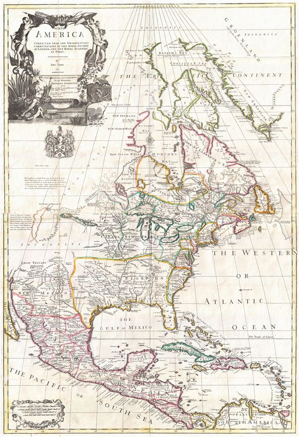
North America corrected from the observations communicated to the Royal Society at London, and the Royal Academy at Paris.
sold
- Digital Map Information
- Suitable for large format printing
- Full resolution TIFF file
- ICC color profile embedded
- Delivered instantly via download link
An exceptional and influential 1710 British map of North America by John Senex. Hands down the most ambitions British mapping of North America produced thus far, Senex's large format map covers all of North America from ... (more details)

Marchionatus Moraviae Circulus Brunnensis quem Mandato Caesareo.
sold
- Digital Map Information
- Suitable for large format printing
- DPI: 300
- File Size: 21.72 MB
- File Type: ZIP / TIFF
- ICC color profile embedded
- Delivered instantly via download link
This is a scarce and attractive c. 1720 J. B. Homann map of Brunnensis in the historic region of Central Europe, part of modern day Czech Republic. The map covers the region from Hlinsko to Mohelno in great detail. The ... (more details)

Le Nouveau Guide de L'Etranger dans les 20 Arrondissements De Paris.
sold
- Digital Map Information
- Suitable for large format printing
- File Size: 26.96 MB
- File Type: ZIP / TIFF
- ICC color profile embedded
- Delivered instantly via download link
This is an extremely attractive 1873 map of Paris, France by A. Logerot. Centered on the Seine, this map covers central Paris as contained by the Thiers Wall. Reflects the transformation and modernization of Paris under ... (more details)

Bird's-Eye View of Washington City, D.C.
sold
- Digital Map Information
- Suitable for large format printing
- File Size: 8.74 MB
- File Type: ZIP / TIFF
- ICC color profile embedded
- Delivered instantly via download link
This is a beautiful 1872 view of Washington, D.C., by W. H. Morrison. Centered on the Capitol, the map beautifully illustrates various important landmarks, including the Smithsonian Institute, Washington Monument, ... (more details)

Clason's Guide Map of Colorado.
sold
- Digital Map Information
- Suitable for large format printing
- File Size: 19.51 MB
- File Type: ZIP / TIFF
- ICC color profile embedded
- Delivered instantly via download link
This is a beautiful 1920 map of Colorado by George Clason. The map covers the entire state in great detail, including the White River National Forest, Hayden National Forest, Colorado National Forest, among ... (more details)

June 1922 San Francisco Merchants. City Map Street Car Shopping and Amusement Guide.
sold
- Digital Map Information
- Suitable for large format printing
- File Size: 10.68 MB
- File Type: ZIP / TIFF
- ICC color profile embedded
- Delivered instantly via download link
This is a fine 1922 map or plan of the city of San Francisco, California, issued by the Merit Press. The map, oriented to the east, covers from Presidio Military Reservation (Presidio Park) south as far as ... (more details)