
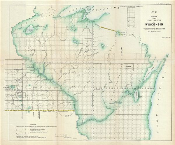
(No. 1.) Sketch of the Public Surveys in Wisconsin and Territory of Minnesota.
sold
- Digital Map Information
- Suitable for large format printing
- File Size: 11.54 MB
- File Type: ZIP / TIFF
- ICC color profile embedded
- Delivered instantly via download link
This is an attractive example of the 1855 public survey map of Wisconsin and parts of the Minnesota Territory prepared by Warner Lewis, Surveyor General in the Surveyor Office in Dubuque. The map covers the entire state of Wisconsin and the parts of the Territory ... (more details)

(No. 2.) Sketch of the Public Surveys in Iowa.
sold
- Digital Map Information
- Suitable for large format printing
- File Size: 10.1 MB
- File Type: ZIP / TIFF
- ICC color profile embedded
- Delivered instantly via download link
This is an attractive example of the 1855 public survey map of Iowa prepared by Warner Lewis, Surveyor General of Iowa. The map covers the entire state of Iowa. Most of the significant survey work is completed or under process, except the northwest corner, with ... (more details)
One of the earliest maps to name Seattle.

Map of a Part of the Territory of Washington to Accompany Report of Surveyor General 1855.
sold
- Digital Map Information
- Suitable for large format printing
- File Size: 10.44 MB
- File Type: ZIP / TIFF
- ICC color profile embedded
- Delivered instantly via download link
One of the earliest surveys of Washington Territory and one of the earliest maps to identify Seattle. This is an attractive first edition example of the 1855 public survey map of a part of the Washington Territory prepared by James Tilton, Surveyor General of ... (more details)

A, (1&2.) Arkansas.
sold
- Digital Map Information
- Suitable for large format printing
- File Size: 9.71 MB
- File Type: ZIP / TIFF
- ICC color profile embedded
- Delivered instantly via download link
This is an attractive example of the 1855 public survey map of Arkansas prepared by Henry M. Rector, Surveyor General of Arkansas. The map covers the entire state of Arkansas. The state of the Land Survey is also noted via a series of blocks representing ... (more details)
Identifies the defunct colonization attempts of the Dutch con-artist Baron de Bastrop.

(H) Map of Louisiana Representing the Several Land Districts.
sold
- Digital Map Information
- Suitable for large format printing
- File Size: 8.87 MB
- File Type: ZIP / TIFF
- ICC color profile embedded
- Delivered instantly via download link
This is an attractive example of the 1855 public survey map of Louisiana prepared by Wm. J. McCulloh, Surveyor General of Louisiana. The map covers the entire state of Louisiana. The state of the Land Survey is also noted via a series of blocks ... (more details)
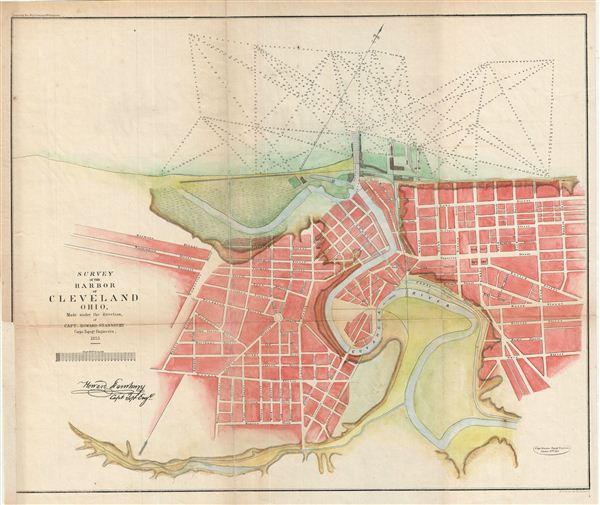
Survey of the Harbor of Cleveland Ohio.
sold
- Digital Map Information
- Suitable for large format printing
- File Size: 10.1 MB
- File Type: ZIP / TIFF
- ICC color profile embedded
- Delivered instantly via download link
This is an uncommon example of the Howard Stansbury's 1853 topographical survey map of the Cleveland Harbor, Ohio. The map covers the city of Cleveland from Monroe Street (Monroe Ave) to Front Street (Front Ave) and shows soundings in feet. ... (more details)
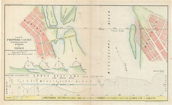
Plan of the Proposed Causey. For the Improvement of the Harbor of Dubuque.
sold
- Digital Map Information
- Suitable for large format printing
- File Size: 3.53 MB
- File Type: ZIP / TIFF
- ICC color profile embedded
- Delivered instantly via download link
This is an uncommon example of the 1855 Corps of Topographical engineers map illustrating the proposed causey (route) at Dubuque Harbor, Iowa. The map covers from Dubuque to Dunleith across the Mississippi River and features a longitudinal ... (more details)

Map of the Five Cities of New York, Brooklyn, Jersey City, Hoboken & Hudson City.
sold
- Digital Map Information
- Suitable for large format printing
- File Size: 46.93 MB
- File Type: ZIP / TIFF
- ICC color profile embedded
- Delivered instantly via download link
This is an uncommon example of Matthew Dripps' two panel 1860 map of New York, Brooklyn, Jersey City, and Hoboken. Issued as a set of two maps (plate 1 and 2), with plate 1 covering from Westchester to 63nd street in Manhattan and from ... (more details)
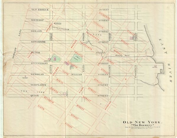
Old New York. 'The Bouwery.'
sold
- Digital Map Information
- Suitable for large format printing
- File Size: 8.31 MB
- File Type: ZIP / TIFF
- ICC color profile embedded
- Delivered instantly via download link
This is a fascinating example of the 1868 map of the Bowery, New York City. The map overlays the pre 1811 street grid with the modern street grid as laid out by the Commissioner's Plan. The contemporary grid covers the neighborhood in ... (more details)
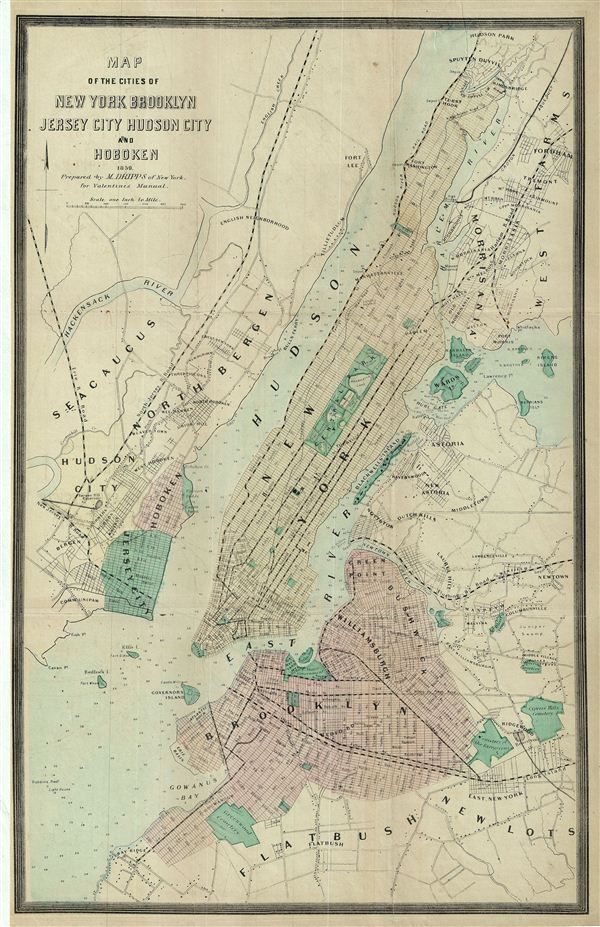
Map of the Cities of New york brooklyn Jersey City Hudson City and Hoboken.
sold
- Digital Map Information
- Suitable for large format printing
- File Size: 8.83 MB
- File Type: ZIP / TIFF
- ICC color profile embedded
- Delivered instantly via download link
This is a fine example of the 1859 Dripps map of the cities of New York, Brooklyn, Jersey City, and Hoboken, issued for Valentine's Manual of the Corporation of New York . The map covers the entirety of New York City, including ... (more details)
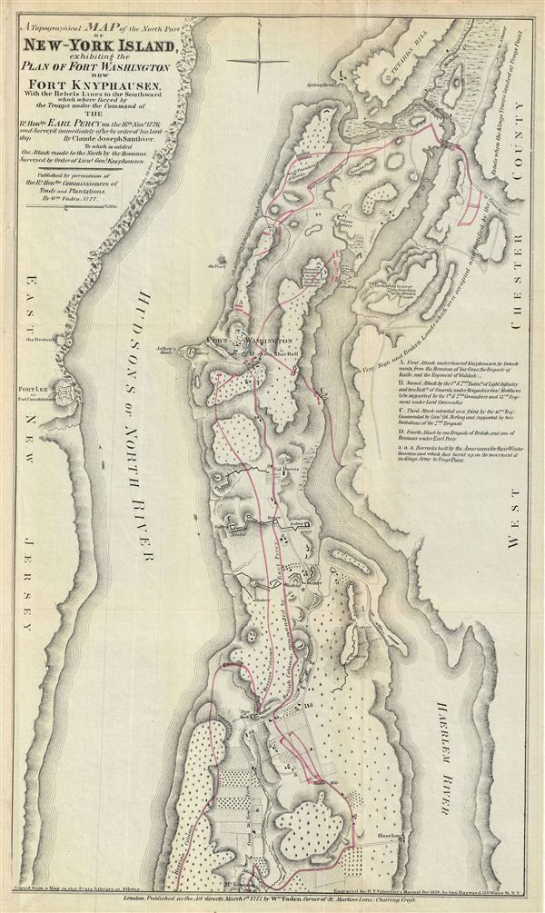
A Topographical Map of the North Part of New-York Island, exhibiting the Plan of Fort Washington, now Fort Knyphausen, With the Rebels Lines to the Southward, which were forced by the Troops under the Command of the Rt. Honble. Earl Percy on the 16th Novr. 1776, and Survey'd immediately after by order of his Lordship. By Claude Joseph Sauthier.
sold
- Digital Map Information
- Suitable for large format printing
- File Size: 7.09 MB
- File Type: ZIP / TIFF
- ICC color profile embedded
- Delivered instantly via download link
This is an uncommon of the northern part of New York City issued 1860 for Valentine's Manual of the Corporation of New York . Originally prepared in 1777 by William Faden to illustrate the struggle for control of New York City ... (more details)

Plan of the Central Park, City of New York, 1860.
sold
- Digital Map Information
- Suitable for large format printing
- File Size: 3.73 MB
- File Type: ZIP / TIFF
- ICC color profile embedded
- Delivered instantly via download link
This is an attractive hand colored map of New York City's Central Park issued in 1860 for Valentine's Manual of the Corporation of New York . Depicts the park as a whole and includes pathways, lakes, buildings, individual ... (more details)
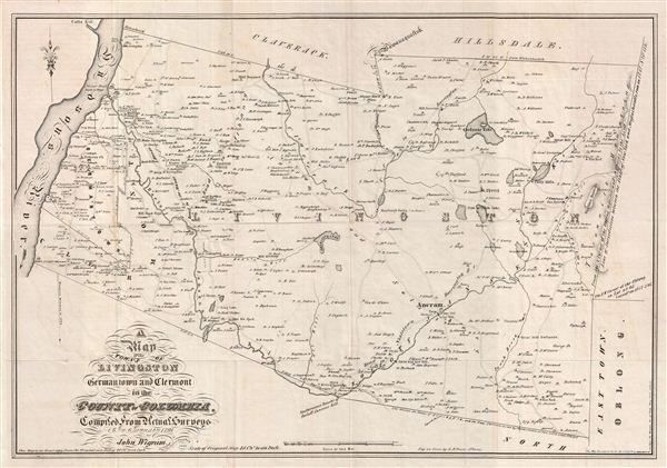
A Map of the Towns of Livingston Germantown and Clermont in the County of Columbia.
sold
- Digital Map Information
- Suitable for large format printing
- DPI: 300
- File Size: 12.05 MB
- File Type: ZIP / TIFF
- ICC color profile embedded
- Delivered instantly via download link
This is a fine example of David Vaughan's 1850 reissue of John Wigram 1798 map of the towns of Livingston, Germantown and Clermont in Columbia County, New York. The map covers the Hudson River to the boundary of ... (more details)
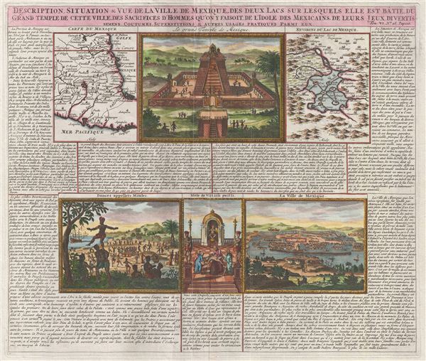
Description, Situation & Vue de la Ville de Mexique, des Deux Lacs sur lesquels elle est Batie, du Grand Temple de cette Ville, des Sacrifice d'Homme qu'on y Faisoit, de l'Idole des Mexicains, de Leurs Jeus Divertis semens, Coutumes, Superstitions & Atures Usages Pratiques Parmi Eux.
sold
- Digital Map Information
- Suitable for large format printing
- DPI: 300
- File Size: 11.43 MB
- File Type: ZIP / TIFF
- ICC color profile embedded
- Delivered instantly via download link
An exceptionally beautiful example of Abraham Chatelain's 1719 map and view sheet focusing on Mexico. This sheet combines two maps and four engraved views with extensive text describing the lands and customs of ... (more details)
Unusual board game with round-the-world theme.

[Around the World - Untitled]
sold
- Digital Map Information
- Suitable for large format printing
- File Size: 8.4 MB
- File Type: ZIP / TIFF
- ICC color profile embedded
- Delivered instantly via download link
An unusual c. 1900 Parker Brothers board game with an 'around the world' theme. Players start in New York and work their way to London Paris, Amsterdam, Vienna, Rome, Naples, Constantinople, Cairo, Suez, ... (more details)
Rare view of the 1893 Chicago Columbian Exposition in a series of trade cards - from the Charles Rand Penny Collection.

Bird's Eye View of the World's Columbian Exposition.
sold
- Digital Map Information
- Suitable for large format printing
- File Size: 9.68 MB
- File Type: ZIP / TIFF
- ICC color profile embedded
- Delivered instantly via download link
A scarce and remarkable discovery, this is an 1892 bird's eye view of the Chicago World's Fair or World's Columbian exposition. The view, prepared by Star Publishing Company, is a chromolithograph ... (more details)
Rare and important nautical chart of the the Zhujiang River Estuary, featuring Macao, Gunagzhou, and Hong Kong.

Carte de L'Entre de Macao aved la Route des Vaisseaux pour se rendre a Wampou et celle des Bateaux de Pays pour aller par l'interieur a Quanton.
sold
- Digital Map Information
- Suitable for large format printing
- DPI: 300
- File Size: 9.93 MB
- File Type: ZIP / TIFF
- ICC color profile embedded
- Delivered instantly via download link
An extremely scarce and obscure 1808 map of Macao, Canton, Lantau, and parts of Hong Kong by Chretien-Louis-Joseph de Guignes. This map is the most important of five charts prepared to illustrate ... (more details)

Platon sur le cap Sunium au Milieu de ses Disciples.
sold
- Digital Map Information
- Suitable for large format printing
- DPI: 300
- File Size: 4.9 MB
- File Type: ZIP / TIFF
- ICC color profile embedded
- Delivered instantly via download link
This is a fascinating example of the 1791 Bocage view of Cape Sounion in Ancient Greece. The site is famous for the ruins of the Temple of Poseidon (the Greek God of the sea). This view features ... (more details)
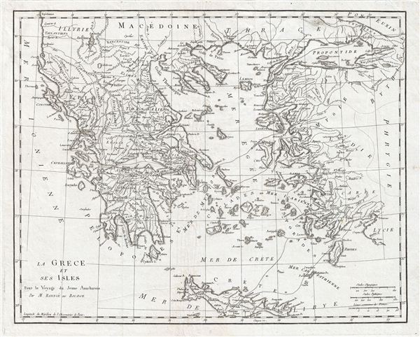
La Grece et ses Isles Pour le Voyagedu Jeune Anacharsis.
sold
- Digital Map Information
- Suitable for large format printing
- DPI: 300
- File Size: 11.14 MB
- File Type: ZIP / TIFF
- ICC color profile embedded
- Delivered instantly via download link
This is an attractive 1791 map of Ancient Greece. It includes Crete, the islands of the Aegean Sean and the parts adjacent Turkey. Take from the early D'Anville map. Notes important cities and ... (more details)
The narrow pass that was the site of the Battle of Thermopylae, featured in the 2007 Hollywood blockbuster '300'.
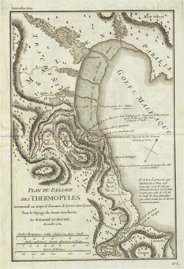
Plan du Passage des Thermo-pyles accommode' au temps de l'invasion de Xerxes dans la Grece Pour le Voyage du Jeune Anacharsis.
sold
- Digital Map Information
- Suitable for large format printing
- DPI: 300
- File Size: 5.91 MB
- File Type: ZIP / TIFF
- ICC color profile embedded
- Delivered instantly via download link
This is a fascinating 1784 map or plan of the Thermopylae Pass in Ancient Greece. Also known as 'The Hot Gateway' due to the numerous sulfur springs. This pass is the site if the famous 480 BC ... (more details)