

Center Moriches Town of Brookhaven Suffolk Co.
sold
- Digital Map Information
- Suitable for large format printing
- File Size: 2.2 MB
- File Type: ZIP / TIFF
- ICC color profile embedded
- Delivered instantly via download link
This scarce and large hand colored map depicts the town of Moriches, Long Island, New York. Map depicts the cities and towns of Center Moriches, including Brookhaven, Blue Point and Eastport. Eastport inset includes the town of Southampton. The extraordinary ... (more details)
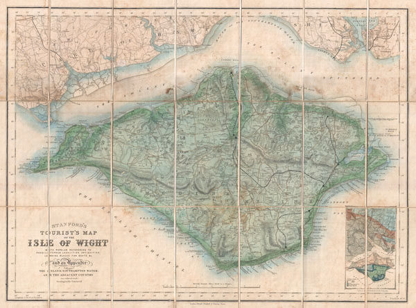
Stanford's Tourist's Map of the Isle of Wight with popular references to Fossili Ferous Localities, Antiquities, Landing Places for Boats, &c. and an Appendix showing the Island, Southampton Water, and the Adjacent Country.
sold
- Digital Map Information
- Suitable for large format printing
- File Size: 18.03 MB
- File Type: ZIP / TIFF
- ICC color profile embedded
- Delivered instantly via download link
An uncommon 1879 pocket map of the Isle of Wight prepared by Edward Stanford. Covers the entire island as well as adjacent parts of Hampshire across the Solent Spithead. Wight is known for its unusual geology and ancient fossil's. This map attempts to locate ... (more details)

Johnson’s Map of the Vicinity of Richmond, and Peninsular Campaign in Virginia Showing also the interesting localities along the James, Chickahominy and York Rivers. Compiled from the official maps of the War Department.
sold
- Digital Map Information
- Suitable for large format printing
- File Size: 5.37 MB
- File Type: ZIP / TIFF
- ICC color profile embedded
- Delivered instantly via download link
This is a rare and important 1862 map of the Vicinity of Richmond during the civil war by A. J. Johnson. Shows the Union Advance during the Peninsular Campaign of the American Civil war. Also includes considerable detail ranging from soundings to individual ... (more details)
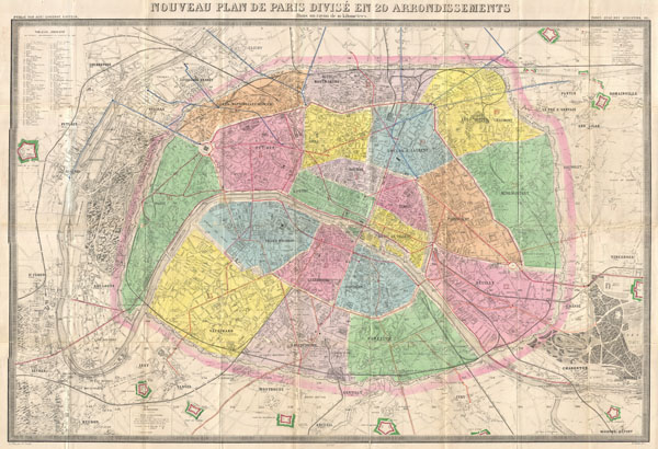
Nouveau Plan de Paris Divise en 20 Arrondissements Dans un rayon de 10 kilometres.
sold
- Digital Map Information
- Suitable for large format printing
- File Size: 50.89 MB
- File Type: ZIP / TIFF
- ICC color profile embedded
- Delivered instantly via download link
An extremely large 1878 pocket of Paris by A. Logerot. Covers the walled center of Paris as well as its immediate vicinity, including the Bois de Boulogne and Bois de Vincennes. All streets and many important buildings are noted throughout. Color coded by ... (more details)
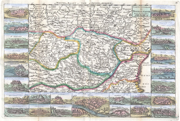
Carte Nouvelle de Transilvanie Avec ses Consins
sold
- Digital Map Information
- Suitable for large format printing
- Full resolution TIFF file
- ICC color profile embedded
- Delivered instantly via download link
A very scarce, c. 1710, map of Transylvania and Moldova by Daniel de la Feuille. Depicts the region of eastern Europe just west of the Black Sea, south of the Ukraine, and north of Bulgaria. Features inset views of 25 important regional trading centers: ... (more details)
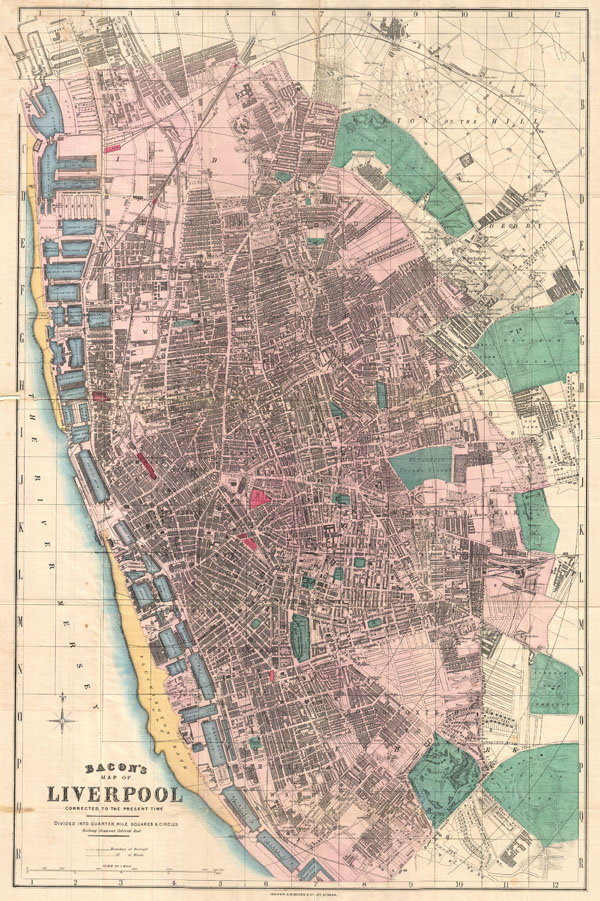
Bacon's Map of Liverpool Corrected to the Present Time.
sold
- Digital Map Information
- Suitable for large format printing
- File Size: 20.97 MB
- File Type: ZIP / TIFF
- ICC color profile embedded
- Delivered instantly via download link
This is Bacon's scarce c. 1890 travellers pocket map of Liverpool, England. Cartographically Bacon derived this map from the Ordinance Survey with embellishments including quarter mile grid and square segmentation, beautiful hand tinting, and a focus on ... (more details)
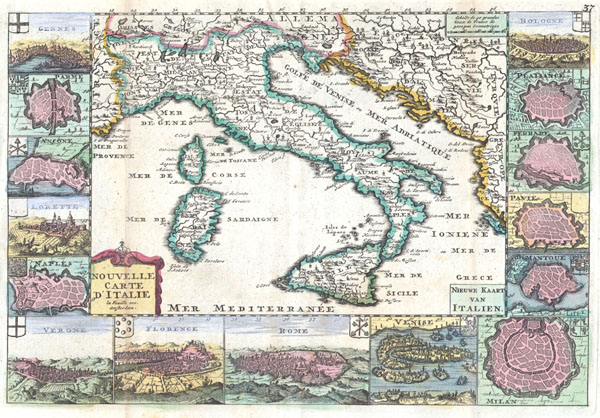
Nouvelle Carte D’Itlaie / Nieuwe Kaart van Italien.
sold
- Digital Map Information
- Suitable for large format printing
- Full resolution TIFF file
- ICC color profile embedded
- Delivered instantly via download link
A very scarce, c. 1706, map of Italy issued by Daniel de La Feuille. Extends from Provence in the west to Serbia and the Island of Corfu in the east. Extends north as far as Switzerland and south as far as Sicily. Includes the islands of Corsica and ... (more details)
Levassuer's stunning map of the Bordeaux wine region.

Dept. de la Gironde.
sold
- Digital Map Information
- Suitable for large format printing
- File Size: 10.12 MB
- File Type: ZIP / TIFF
- ICC color profile embedded
- Delivered instantly via download link
This is a fascinating 1861 map of the French department of Gironde. This coastal department is the seat of the Bordeaux wine region and produces many of the world's finest reds. Shows numerous vineyards and chateaux. The whole is surrounded by ... (more details)

Colonies Francaises. (en Afrique.)
sold
- Digital Map Information
- Suitable for large format printing
- Full resolution TIFF file
- ICC color profile embedded
- Delivered instantly via download link
This is a fascinating 1847 map of the French colonies of Madagascar, Senegal, and the Gambia, is divided into two sections: Madagascar and Senegambie. Senegambie features a close up of the Senegal River and the Island of St. Louis. The ... (more details)
Extremely unusual Colton Railroad Map of Long Island, New York.

Map of Long Island Showing the Long Isladn Railroad and its Leased Lines.
sold
- Digital Map Information
- Suitable for large format printing
- File Size: 5.67 MB
- File Type: ZIP / TIFF
- ICC color profile embedded
- Delivered instantly via download link
A highly uncommon railroad map of Long Island, New York dating to 1882. Depicts Long Island in full inclusive of Manhattan, Brooklyn, the Long Island Sound, and the southern shore of Connecticut. Color coded in red, green, yellow and ... (more details)

A Chart of the Islands discovered in the Neighbourhood of Otaheite, in the Course of Several Voyages round the World Made by the Capts. Byron, Wallis, Carteret, & Cook.
sold
- Digital Map Information
- Suitable for large format printing
- DPI: 300
- File Size: 1.25 MB
- File Type: ZIP / TIFF
- ICC color profile embedded
- Delivered instantly via download link
This is a rare map of the Society Islands in the South Pacific published by Alexander Hogg to illustrate the voyages and discoveries of the sea captains Byron, Wallis, Carteret ad Cook. This map contains references to the cartographic ... (more details)
One of the Mitchell plans of New York to show the Brooklyn Bridge.
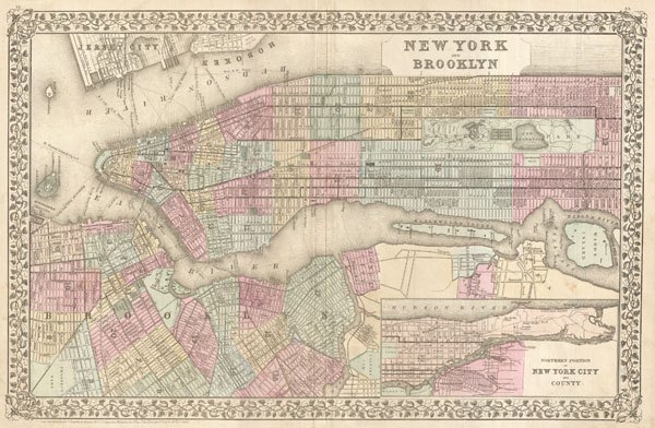
New York and Brooklyn.
sold
- Digital Map Information
- Suitable for large format printing
- File Size: 12.27 MB
- File Type: ZIP / TIFF
- ICC color profile embedded
- Delivered instantly via download link
This beautiful hand colored map is a lithographic engraving of New York City, dating to 1882, by the legendary American map publisher S.A. Mitchell, Junior. Covers all of Manhattan and much of Brooklyn as well as adjacent parts of ... (more details)

The Constellations for Each Month in the Year.
sold
- Digital Map Information
- Suitable for large format printing
- File Size: 3.43 MB
- File Type: ZIP / TIFF
- ICC color profile embedded
- Delivered instantly via download link
This rare hand colored map of the stars of the northern hemisphere was engraved W. G. Evans of New York for Burritt's 1856 edition of the Atlas to Illustrate the Geography of the Heavens. It represents the night sky and ... (more details)

Essay on the Battle of Plataea for the Travels of Anacharsis.
sold
- Digital Map Information
- Suitable for large format printing
- Full resolution TIFF file
- ICC color profile embedded
- Delivered instantly via download link
This is a fascinating 1784 color map showing the Battle of Plataea by Barbie du Bocage. The battle of Plataea occurred in 479 BC and was the last battle in the second Persian invasion of Greece. It took place near the ... (more details)

The Constellations for Each Month in the Year.
sold
- Digital Map Information
- Suitable for large format printing
- File Size: 3.35 MB
- File Type: ZIP / TIFF
- ICC color profile embedded
- Delivered instantly via download link
This rare hand colored map of the stars of the southern hemisphere was engraved W. G. Evans of New York for Burritt's 1856 edition of the Atlas to Illustrate the Geography of the Heavens. It represents the night sky ... (more details)
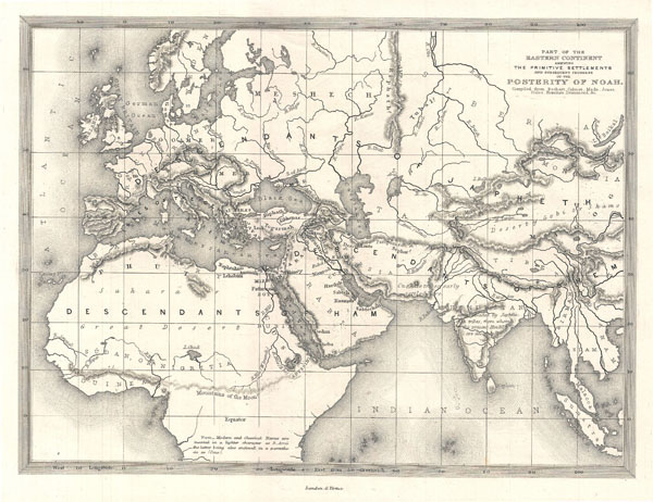
Part of Eastern Continent Shewing The Primitive Settlements and Subsequent Progress of the Posterity of Noah
sold
- Digital Map Information
- Suitable for large format printing
- Full resolution TIFF file
- ICC color profile embedded
- Delivered instantly via download link
This is a beautiful c. 1850 map of Europe, northern Africa, and western Asia. Drawn to illustrated the 'Primitive Settlements and Subsequent Progress of the Posterity of Noah compiled from Bochart, Calmet, Mede, ... (more details)

Telescopic View of the Moon
sold
- Digital Map Information
- Suitable for large format printing
- Full resolution TIFF file
- ICC color profile embedded
- Delivered instantly via download link
This is an 1886 Telescopic View of the Moon. Names lunar seas, or gray plains, and lunar ring-mountains and craters. Black and white. Astronomical information on the ... (more details)

Isle et Royaume d'Irlande.
sold
- Digital Map Information
- Suitable for large format printing
- Full resolution TIFF file
- ICC color profile embedded
- Delivered instantly via download link
A rare and beautiful 1748 Map of Ireland by the French cartographer Robert de Vaugondy. Depicts the entire island with county and regional subdivisions defined. ... (more details)

Mappa Dispersus Filiorum Noemi
sold
- Digital Map Information
- Suitable for large format printing
- Full resolution TIFF file
- ICC color profile embedded
- Delivered instantly via download link
This is a 1787 Rigobert Bonne map of the Dispersal Sons of Noah. The map covers the area between Arabia, the Black Sea and Caspian Sea. Focuses on the territory ... (more details)
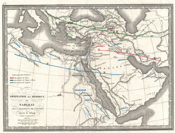
Geographie des Hebreux et Tableau de la Dispersion des Peuples Apres le Deluge
sold
- Digital Map Information
- Suitable for large format printing
- Full resolution TIFF file
- ICC color profile embedded
- Delivered instantly via download link
This is an 1839 C.V. Monin map of the Dispersal of the Hebrew Peoples After the Flood. This beautifully drawn map covers the lands occupied by the modern day ... (more details)