
Ottoman Maps (sold)
First Islamic Wall Map of the Arabian Peninsula.
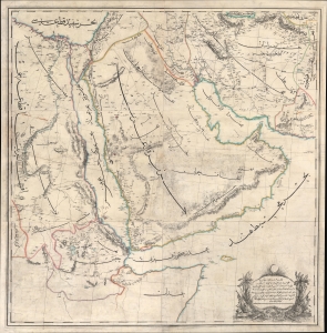
...مملك محروسهء شاهانه دن آسيا / [The Royal Palace of Asia...].
sold
- Digital Map Information
- Suitable for large format printing
- File Size: 172.65 MB
- File Type: ZIP / TIFF
- ICC color profile embedded
- Delivered instantly via download link
A rare large-format 1871 Ottoman wall map of Arabia by military officer Yusbasi Husni (Hüsnü) Efendi. This is the earliest known large-scale Islamic wall map of Arabia. It was produced amid major administrative changes and cartographic developments, when the Ottoman Empire was securing its tenuous control of Mecca, Medina, and Yemen against both internal and external pressure. (more details)
Extremely rare Map of the United States in Ottoman-Turkish Arabic Script.
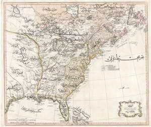
Amerika.
sold
- Digital Map Information
- Suitable for large format printing
- DPI: 300
- File Size: 62.39 MB
- File Type: ZIP / TIFF
- ICC color profile embedded
- Delivered instantly via download link
An extraordinary discovery of the utmost importance and rarity, this is Rāif Maḥmūd Efendi's 1803 Ottoman-Turkish map of the United States. The map covers the eastern part of North America from the mouth of the Rio Bravo (Texas) to Newfoundland and from ... (more details)
Key Map from the Earliest Atlas in Armenian.
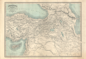
Հայաստամ Աշխարհ Ըստ նախնի աշխարհագրաց / [The Armenian World according to ancient geographers].
sold
- Digital Map Information
- Suitable for large format printing
- File Size: 47.09 MB
- File Type: ZIP / TIFF
- ICC color profile embedded
- Delivered instantly via download link
An exceptional discovery, this 1849 historical map of Armenia appeared in the Illustrated World Atlas, the first atlas published in the Armenian language. The map and atlas are a reflection of a growing Armenian national consciousness in the mid-19th century, which would eventually clash with the late Ottoman state with terrible consequences. (more details)
One-of-a-kind Ottoman Serio-Comic WWI Propaganda Map.
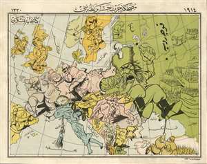
A Háborús Európa Térkép-Karikatúrája. / [A Cartoon War Map of Europe].
sold
- Digital Map Information
- Suitable for large format printing
- File Size: 16.22 MB
- File Type: ZIP / TIFF
- ICC color profile embedded
- Delivered instantly via download link
The only known example of the Ottoman Turkish edition of Varga Imre's important 1914 serio-propaganda map of Europe at the outset of World War I (1814 - 1918), A Háborús Európa Térkép-Karikatúrája. The map is essentially propaganda for the Central Powers wherein Russia appears as an obnoxious drunk and Hungary is illustrated charging fiercely into battle - note, this is the only WWI Era serio-comic map to illustrate Hungary independently. In this Ottoman edition, released in Istanbul by Khaireya and Co. Press, all the text has been translated into Ottoman Turkish. (more details)
Rare Ottoman Broadside Summarizing 19th Century Advances in Geology and Paleontology
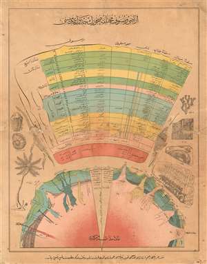
[Presentation of Various Soils and Types of Rocks] اراض و صنوف مختلفه صخورك جدول عهق ملس
sold
- Digital Map Information
- Suitable for large format printing
- File Size: 22.51 MB
- File Type: ZIP / TIFF
- ICC color profile embedded
- Delivered instantly via download link
A striking and extraordinarily rare Ottoman geological scientific broadside, printed in Istanbul around the turn of the 19th century, focusing on the relatively new disciplines of geology and paleontology. The unassuming title (translating to Presentation of Various Soils and Types of Rocks) belies what appears to be a summary of 19th century advances in the earth sciences. At bottom, a stylized cross-section of the Earth shows the planet's molten core and the effects of its pressure on the planet's crust: volcanoes, aquifers, and the development of different strata of rock. The bulk of the diagram appears to correspond to the cut-away, correlating different strata with different periods of geological time. The accompanying images of fossil plants and animals (among them an ammonite, a trilobite, a plesiosaur and an ichthyosaur) relate to the knowledge that certain fossils could be reliably found at strata whose age could be reasonably accurately calculated. (more details)
The Balkans on the Brink.
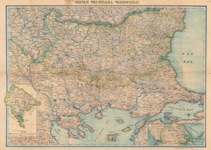
Քարտէս Պալքանէան Պետութեանց / [Map of the Balkan States].
sold
- Digital Map Information
- Suitable for large format printing
- File Size: 56.99 MB
- File Type: ZIP / TIFF
- ICC color profile embedded
- Delivered instantly via download link
This is an extremely rare c. 1898 Armenian-language map of the Balkans prepared by Stepan Agayan and published by the Iqbal Bookshop in Constantinople (Istanbul). It depicts the region at the turn of the 20th century, following the Russo-Turkish War of 1877 - 1878 but before the Balkan Wars that helped set the stage for World War I (1914 - 1918). (more details)
The rise of Atatürk.
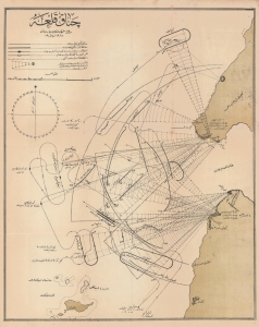
چناققلعه / [Çanakkale].
sold
- Digital Map Information
- Suitable for large format printing
- File Size: 26.52 MB
- File Type: ZIP / TIFF
- ICC color profile embedded
- Delivered instantly via download link
A remarkable 1915 Ottoman Turkish map of the Straits of Dardanelles and the tip of the Gallipoli Peninsula. It details Ottoman gun batteries protecting the opening of the Straits, which were the focal point of naval operations by the Entente Powers in February and March of that year. More specifically, it depicts the operations of February 19, when Entente ships bombarded Ottoman gun batteries to open a safe channel through the Straits. The ultimate failure of Entente ships to break through the Dardanelles led to the amphibious assault for which the Gallipoli Campaign is more famous. It also heralded the rise of Mustafa Kemal Atatürk, who founded the Republic of Turkey and remains an iconic figure. (more details)
Published the year the Republic of Turkey was founded.

Türkiye Cumhuriyeti Haritası. / [Map of the Republic of Turkey].
sold
- Digital Map Information
- Suitable for large format printing
- Full resolution TIFF file
- ICC color profile embedded
- Delivered instantly via download link
This is an enormous 1923 wall map of Turkey in Ottoman Turkish, published the year the modern Republic of Turkey was founded. The cartographer uses different colors to mark Turkey's extreme topography. Shades of brown illustrate elevation changes, while areas of green highlight river valleys and other fertile zones. (more details)
Southeastern Europe, Slipping Away.
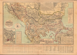
مفصل اوروبا عثمانیه / [Detailed (Map) of Ottoman Europe].
sold
- Digital Map Information
- Suitable for large format printing
- File Size: 1159.59 MB
- File Type: ZIP / TIFF
- ICC color profile embedded
- Delivered instantly via download link
A scarce map of Ottoman Europe, produced by military officer al-Hac Nasir al-Dagistani and published in 1906 by Mahmud Bey Matbaasi. It displays the remaining European portion of the Ottoman Empire, which was severely imperiled at the time, and most of which would break away in two wars in the Balkans that directly preceded World War I (1914 - 1918). (more details)
An extremely rare 19th century map of Southeast Asia in Ottoman-Turkish script.
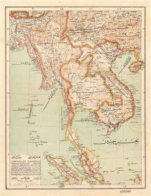
هندچينى سيام. / [Hindochina. Siam]
sold
- Digital Map Information
- Suitable for large format printing
- File Size: 15.25 MB
- File Type: ZIP / TIFF
- ICC color profile embedded
- Delivered instantly via download link
An incredibly rare and extremely attractive map, this is a c. 1895 Ali Şeref Paşa map of Southeast Asia in Ottoman script. From one of the largest 19th century Ottoman atlases, the Yeñi coġrafya aṭlası, the map depicts the region from modern-day Bangladesh to Hainan and from southern China to Sumatra and Borneo. Highly detailed, myriad locations are labeled and international borders are noted by this lines of various colors, making it easy to differentiate between the different nations. (more details)
An extremely rare 19th century map of Florida and the West Indies in Ottoman-Turkish script.
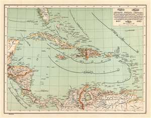
[Central America. Antilles Islands]. / اطلرى انتيل .وسطى ىمريقاى
sold
- Digital Map Information
- Suitable for large format printing
- File Size: 12.91 MB
- File Type: ZIP / TIFF
- ICC color profile embedded
- Delivered instantly via download link
An incredibly rare and extremely attractive map, this is a c. 1893 Ali Şeref Paşa map of the Caribbean in Ottoman script. From one of the largest 19th century Ottoman atlases, the Yeñi coġrafya aṭlası, the map depicts the region from the Yucatán Peninsula to the Leeward Islands and from Florida to northern South America. Highly detailed, myriad locations on islands in the Caribbean, Central America, and South America are labeled. (more details)
A map of the Middle East in Ottoman Turkish with a few manuscript notations in Turkish.
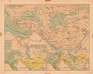
[Persia and the Middle East].
sold
- Digital Map Information
- Suitable for large format printing
- Full resolution TIFF file
- ICC color profile embedded
- Delivered instantly via download link
This is a c. 1930 map of Iran and the Middle East with Ottoman Turkish text. The map depicts the region from southern Italy to the Indus River and from the Black Sea to the Persian Gulf and the Red Sea. Locations throughout the region are identified in ... (more details)
One of the Only Acquirable Turkish Maps of Singapore and Borneo
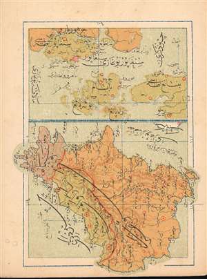
(Turkish Map of Singapore and Borneo)
sold
- Digital Map Information
- Suitable for large format printing
- File Size: 1.15 MB
- File Type: ZIP / TIFF
- ICC color profile embedded
- Delivered instantly via download link
This is a 1909 Turkish map of the Singapore Strait and island of Singapore, combined with a map of Borneo, produced by the Turkish educator and publisher Mehmet Eşref. Most likely the only specific Ottoman map of these areas available to the collector. All titles and descriptive text are in Ottoman Turkish. On the Singapore Straits portion of the map, the city of Singapore itself is marked in red hachure. The map of Borneo is oriented to the west, and its colonial division between the English and the Dutch -which would materially affect the political boundaries of post-colonial Borneo- is indicated with color. Chromolithograph. (more details)
Attracive Miniature Turkish Hemisphere Maps
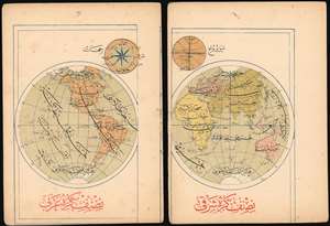
[Turkish Maps of the Eastern and Western Hemispheres]
sold
- Digital Map Information
- Suitable for large format printing
- File Size: 2.15 MB
- File Type: ZIP / TIFF
- ICC color profile embedded
- Delivered instantly via download link
This is a pair of 1909 Turkish Eastern and Western Hemisphere maps, produced by the educator and publisher Mehmet Eşref. Together they comprise one of the few Turkish maps of the world available to the collector. All titles and descriptive text are in Ottoman Turkish. National borders are not shown, but large geographical features - the Great Lakes, the Mississippi River, the Amazon and the Nile do appear. Antarctica is shown in a tentative fashion. Chromolithograph. (more details)
A Rare, Attractive Miniature Turkish Plan of Istanbul
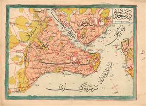
(Turkish Plan of Istanbul and its Surrounds)
sold
- Digital Map Information
- Suitable for large format printing
- File Size: 1.33 MB
- File Type: ZIP / TIFF
- ICC color profile embedded
- Delivered instantly via download link
This is a 1909 Turkish plan of Istanbul, produced by the Turkish educator and publisher Mehmet Eşref. All titles and descriptive text are in Ottoman Turkish. Areas within the city and its suburbs are made distinct with color. Depth soundings are noted in the waterways, and the famous 'Maiden's Tower,' or Kiz Kulesi, is marked just off the shore from Üsküdar. Chromolithograph. (more details)
Uncommon Ottoman-Turkish map of the West Indies.
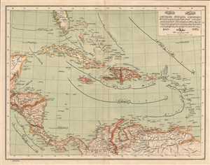
[West Indies]
sold
- Digital Map Information
- Suitable for large format printing
- File Size: 4.09 MB
- File Type: ZIP / TIFF
- ICC color profile embedded
- Delivered instantly via download link
This is an 1893 Ottoman-Turkish map of the West Indies. Centered on the Antilles, the map depicts from the Yucatan Peninsula to Trinidad and Tobago and Venezuela and from southern Florida to Colombia and Venezuela. Cuba, Haiti, the Dominican Republic, ... (more details)