
Anti-Vietnam War Poster issued in response to the My Lai Massacre.

if anyone in days to come should say that we were civilized in this country, this war will be cited as proof we were barbarians.
sold
This is a 1970 Mark Podwal anti-Vietnam War propaganda poster map of the United States. Podwal combines iconic American imagery with quotations illustrating how lost the American people were by 1970. In many instances, Podwal is referencing the 1968 My Lai Massacre. (more details)
Earliest known map of Bangkok.
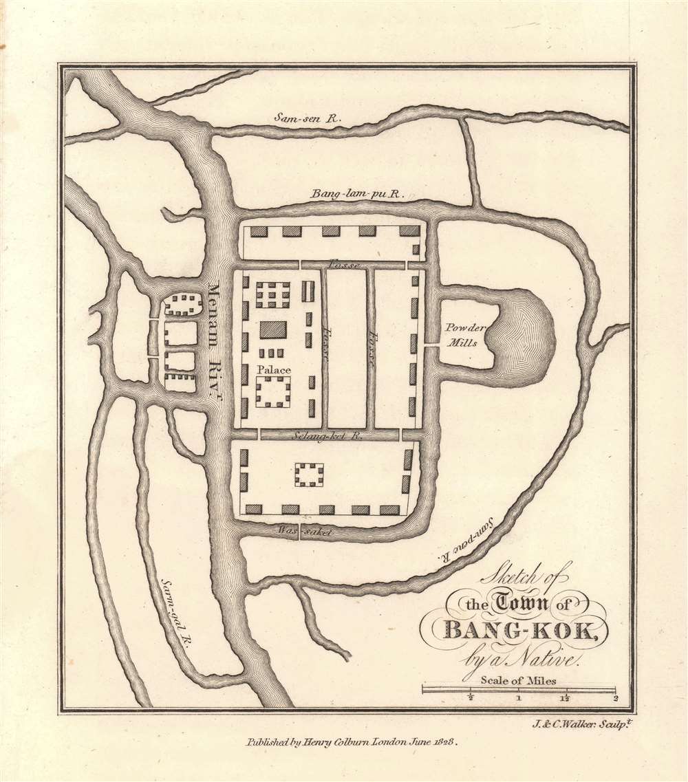
Sketch of the Town of Bang-Kok, by a Native.
sold
- Digital Map Information
- Suitable for large format printing
- Full resolution TIFF file
- ICC color profile embedded
- Delivered instantly via download link
This is the earliest known map of Bangkok, Thailand, issued in 1828, shortly after John Crawfurd's diplomatic mission to the royal court of Siam. The map itself purports to be 'by a native' and was likely drawn for Crawfurd in 1822 when he visited. The map is oriented to the north, with the Royal Palace and temple complex at the center. The Chao Phraya River is identified here by the archaic name Manam. The area covered roughly corresponds to the modern-day Grand Palace and Wat Pho complex. The Powder Mills at the right of the palace are today Saranrom. Some English terminology is used, but waterway names are anglicized Thai. (more details)
Scarce View of Jerusalem with metallic printing.

Jerusalem.
sold
This is a striking 1969 Herman Bollmann bird's-eye view pictorial map of Jerusalem printed with metallic ink. (more details)
Celebrating 30 Years of the Nation of Israel

ישראל תש'ח-תשל'ח 1948-1978 / [Israel 5708 - 5738 1948 - 1978]. / מתש'ח לתשל'ח - מפת הישגים [5708 - 5738 - A Map of Achievements].
sold
An impressive Hebrew-language map of Israel, published in 1978 by the Survey of Israel to celebrate the 30th anniversary of the nation's founding. (more details)
A moment of explosive growth.

Birds Eye View of New-York and Brooklyn.
sold
- Digital Map Information
- Suitable for large format printing
- File Size: 46.8 MB
- File Type: ZIP / TIFF
- ICC color profile embedded
- Delivered instantly via download link
This is an 1850 John Bachmann rare bird's-eye view of New York City and Brooklyn. The work captures New York at a moment of explosive growth due to rapid industrialization and waves of new immigration - specifically, highly educated middle-class merchants and tradesmen from Germany and Central Europe (like Bachmann himself) fleeing in the wake of the failed Peoples Revolutions of 1848. (more details)
Chains of Empire.
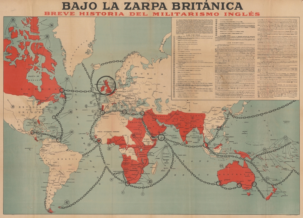
Bajo la Zarpa Británica, Breve historia del militarismo inglés.
sold
- Digital Map Information
- Suitable for large format printing
- File Size: 61.17 MB
- File Type: ZIP / TIFF
- ICC color profile embedded
- Delivered instantly via download link
A fascinating 1918 German-issued Spanish-language World War I broadsheet propaganda map representing the world wrapped in the chains of British militantism and colonialism. Issued by F. Haase, this map was part of the WWI propaganda war waged by both the Allies and Central powers to sway the hearts and minds of neutral nations. (more details)
One of the first charts to name Philadelphia.

Pas kaart van de zee kusten van Virginia : tusschen C. Henry en t hooge land van Renselaars Hoek...
sold
- Digital Map Information
- Suitable for large format printing
- DPI: 600
- File Size: 27.92 MB
- File Type: ZIP / TIFF
- ICC color profile embedded
- Delivered instantly via download link
This is Van Keulen's 1695 nautical chart or maritime map of Chesapeake Bay, Delaware Bay, and the adjacent coastlines. It is one of the first charts to utilize the 1673 Hermann map as a source, making it one of the most up-to-date charts of the region - and a vast improvement on the 1675 Roggeveen, specifically because Van Keulen's chartmaker, Vooght, relied on the English Hermann map rather than Hessel Gerritz's c. 1630 chart. (more details)
Cowboy Culture, by a cowboy.

I dedicate this Carte of Evolution to The California Rodeo of Salinas...
sold
- Digital Map Information
- Suitable for large format printing
- Full resolution TIFF file
- ICC color profile embedded
- Delivered instantly via download link
Considered Jo Mora's most iconic image, this is the 1939 'Evolution of the Cowboy.' The image celebrates all things cowboy, from the rodeo to saddles, steers, and chuckwagons. It is worth noting that Mora became a cowboy himself, and his depictions of cowboy life and culture exhibit realism based on experience. (more details)
Oh Beautiful For Spacious ... Never Mind.

U.S.A. 2000.
sold
This 1972 Postermap of the United States in the year 2000 is a bleakly satirical prediction of the state of the country and the world of the near future. The map, produced 28 years before the subject's date (a mere 24 years ago), depicts a dystopian America corporatized, urbanized, paved, littered, irradiated, automated, and yet insatiable. (more details)
Weaving through the East Indies.
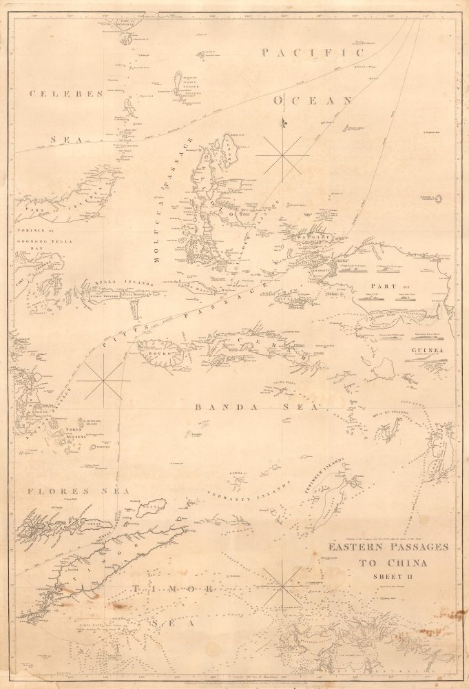
Eastern Passages to China Sheet II.
$800.00
Acquire
- Digital Map Information
- Suitable for large format printing
- File Size: MB
- File Type: ZIP / TIFF
- ICC color profile embedded
- Delivered instantly via download link
A significant blueback nautical chart of a portion of the East Indies (Indonesia) including Timor, the Maluku Islands, and the Banda Sea, originally prepared in 1826 by James Horsburgh and here updated to 1849. As one of the great hydrographers of his day, Horsburgh's charts of the East Indies were among the first detailed nautical charts of these waters, providing essential information for navigators, particularly those working in the China trade. (more details)
Tracing the first European exploration of the Anambas Islands.
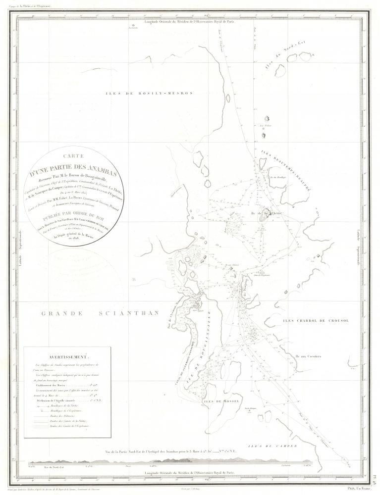
Carte d'une Partie des Anambas Reconnue Par M. le Baron de Bougainville.
$750.00
Acquire
- Digital Map Information
- Suitable for large format printing
- File Size: 9.67 MB
- File Type: ZIP / TIFF
- ICC color profile embedded
- Delivered instantly via download link
This is an 1828 Ambroise Tardieu map of the northeastern part of Siantan Island and the surrounding islands in the Anambas Islands Regency, part of the Riau Archipelago in Indonesia. Bougainville's expedition marks the first European reconnaissance of the Anambas Islands. (more details)
Deciphering the Third Reich's War Machine.

Les trusts du troisième Reich.
sold
- Digital Map Information
- Suitable for large format printing
- File Size: 5.15 MB
- File Type: ZIP / TIFF
- ICC color profile embedded
- Delivered instantly via download link
A scarce and damning infographic, this c. 1946 chart traces the companies and trusts of the Nazi-era German economy and their interconnections with the Nazi regime. It appeared in the booklet Criminels de guerre! Derrière les coulisses. 50 potentats gouvernaient l'Allemagne, aimed at French trade unionists. (more details)
First map of Liberia.
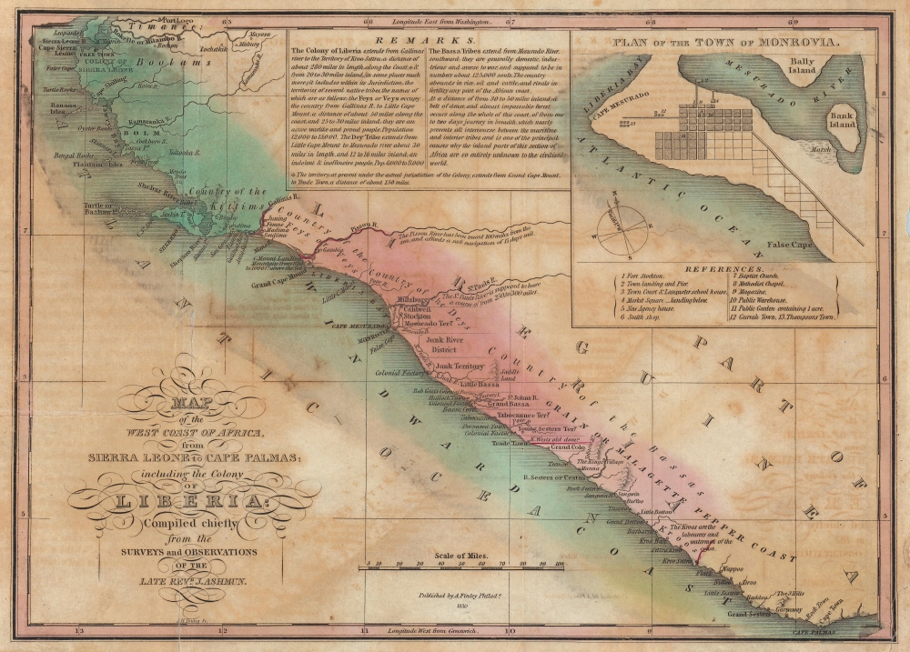
Map of the West Coast of Africa, from Sierra Leone to Cape Palmas; including the Colony of Liberia: Compiled chiefly from the surveys and observations of the Late Revd. J. Ashmun.
sold
- Digital Map Information
- Suitable for large format printing
- Full resolution TIFF file
- ICC color profile embedded
- Delivered instantly via download link
The most important early map of Liberia issued shortly after its founding. This map was published in 1830 by ardent 'Colonization' supporter Anthony Finley based upon the cartography of Jehudi Ashmun. The map depicts the west African coast from Freetown, Sierra Leone, to Cape Palmas. Light red shading indicates territory claimed as Liberia by the American Colonization Society (ACS), while the darker red strip, about 150 miles, indicates regions actually under ACS control. The map is derived from cartography produced by Jehudi Ashmun, an agent of the U.S. Government and the ACS who traveled extensively throughout the region in an attempt to acquire lands and organize peaceful relations with the generally unwelcoming established tribal kingdoms. (more details)
A visual summary of military bases established in Arizona during World War II.

AAF Aeronautical Chart Gila River 405.
sold
- Digital Map Information
- Suitable for large format printing
- Full resolution TIFF file
- ICC color profile embedded
- Delivered instantly via download link
This is a 1945 U.S. Coast and Geodetic Survey aeronautical chart of Arizona. Published near the end of World War II, the map highlights numerous Army, Army Air Force, Navy, and Marine airfields and other installations across the state. The sheer number of bases underscores how much the country dedicated to winning the war and training the soldiers and pilots needed to do so. (more details)
Celebrating Alaska's admission into the Union on January 3, 1959.
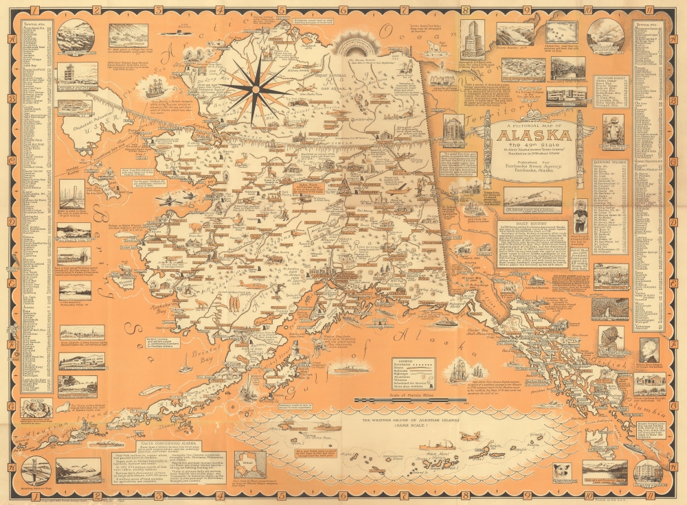
A Pictorial Map of Alaska The 49th State.
sold
This 1959 Ernest Dudley Chase pictorial map of Alaska celebrates January 3, 1959, when President Dwight D. Eisenhower signed the bill making Alaska the 49th state. (more details)
Oklahoma City's Boom Years.

Official Street Guide and Pocket Map of Oklahoma City Oklahoma / Map of Oklahoma City Oklahoma compiled from official records by the Adams Engineering Company.
sold
- Digital Map Information
- Suitable for large format printing
- Full resolution TIFF file
- ICC color profile embedded
- Delivered instantly via download link
A scarce 1925 folding cadastral map of Oklahoma City, Oklahoma, prepared by the Adams Engineering Company and the Kenyon Map Company. Among other features, the quantity of real estate developments reflect the frenetic pace of development in the city in the first half of the 20th century. (more details)
One of San Francisco's Earliest Printers.

Francis, Valentine, and Co. Engraving Designing and Show Printing House.
sold
- Digital Map Information
- Suitable for large format printing
- Full resolution TIFF file
- ICC color profile embedded
- Delivered instantly via download link
A scarce promotional piece that appeared in the San Francisco newspaper The City Argus c. 1879, advertising the services of Francis, Valentine, and Co., an engraver and print shop in the city. (more details)
Highlights Manhattan's many theatres, including the New Amsterdam and Lyric Theatres, as well as the newly-constructed United Nations Headquarters.

Hagstrom's Map of New York Theatres, Hotels, Shopping District and United Nations Headquarters.
sold
- Digital Map Information
- Suitable for large format printing
- Full resolution TIFF file
- ICC color profile embedded
- Delivered instantly via download link
This is a c. 1950 Hagstrom map of Midtown Manhattan highlighting the Theatre District and its many theatres. The map depicts the city from Eighth Avenue to the East River and from West 61st Street, Central Park, and East 61st Street to 26th Street. Although myriad buildings are illustrated, not all the city blocks are filled. Banks, churches, clubs, department stores, hotels, nightclubs, office buildings, public buildings, train stations, and theatres are shaded using various colors to allow for easy differentiation and identification. (more details)
Striking Woodcut map of Greece.

New Griechenlandt mit andern anstossenden Laendern wie es zu unsern zeiten beschriben ist.
sold
- Digital Map Information
- Suitable for large format printing
- Full resolution TIFF file
- ICC color profile embedded
- Delivered instantly via download link
This evocative map of Greece and the Greek Islands was added to Münster's Cosmographia in 1588 as part of Sebastian Petri's extensive update of the work. (more details)
Highlighting parts of Indiana's history.
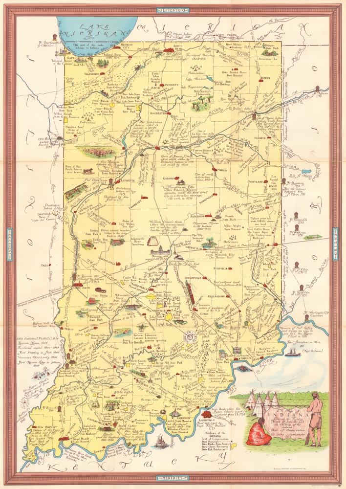
A Map of Indiana Showing its History, Points of Interest, and the holdings of the Indiana Dept. of Conservation.
sold
This is a 1954 Indiana Department of Conservation pictorial map of Indiana. The map highlights Indiana's history and its place in the broader history of the United States. (more details)