
A map of the grounds of the 1940 New York World's Fair published by The New Yorker
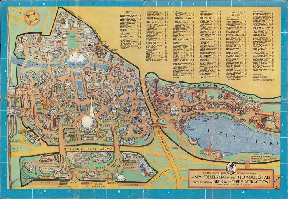
For the Convenience of Our Readers The New Yorker's Map of the 1940 World's Fair Together with an Index to its Chief Attractions.
sold
- Digital Map Information
- Suitable for large format printing
- File Size: 29.3 MB
- File Type: ZIP / TIFF
- ICC color profile embedded
- Delivered instantly via download link
This is a 1940 Carl Rose pictorial map of the 1939-40 New York World's Fair created for The New Yorker. The map depicts the fairgrounds, which were in today's Corona Park, from the Long Island Railroad tracks to the American Jubilee and from Lawrence Street and the Boy Scout Camp to the Transportation section and 111th Street. The focus of the map is the Trylon and Perisphere, the symbol of the World's Fair, and the Lagoon of Nations along the Flushing River. Pavilions, attractions, and restaurants throughout the fair are illustrated in profile and labeled. Most of the government and national pavilions are situated near the top of the fairgrounds around the Court of Peace, while pavilions dedicated to American industries and companies were built throughout the left half of the fair. Some pavilions focused on a theme, such as gas, religion, American Art, sports, science, and public health. Other buildings were erected by corporations, such as AT and T, Coca-Cola, DuPont, Eastman Kodak, General Motors, and Ford. The right portion of the map is dedicated to the Attraction section, which featured the popular Aquacade, Jungle Land, two penny arcades, bowling alleys, and numerous other amusements. Both the I.R.T. Subway and the B.M.T. Subway stations are noted. An index of all the sites throughout the fair is situated along the top border. The title cartouche, situated in the lower right corner, features a portrait of the dandy Eustace Tilly, a drawing by Rea Irvin that appeared on the cover of the first issue and symbolized the magazine ever since. (more details)
An incredible pictorial map tracing the flying career of Charles Lindbergh up to 1928.

Map Showing the Overland and Overseas Flights of Charles A. Lindbergh.
sold
- Digital Map Information
- Suitable for large format printing
- File Size: 94.46 MB
- File Type: ZIP / TIFF
- ICC color profile embedded
- Delivered instantly via download link
This is a 1928 Ernest Clegg pictorial map of the world celebrating Charles Lindbergh's transatlantic flight. The map depicts the world from Alaska to Norway and from the Yukon and Greenland to Brazil and traces Lindbergh's flying career from his first solo flight at Americus, Georgia in 1923 to the delivery of his now world-renowned airplane The Spirit of St. Louis to the Smithsonian Institution in 1928. Each of Lindbergh's flights is traced by a line consisting of arrows illustrating the direction of the flight and other notations, as well as different colors to allow for easier identification of each route. (more details)
Japanese anti-Soviet anti-Communist Propaganda Pictorial!

最近の東 亞形勢圖解 / Illustrated Explanation of Recent East Asia Situations. / Saikin no Tōa keisei zukai.
sold
- Digital Map Information
- Suitable for large format printing
- File Size: 138.77 MB
- File Type: ZIP / TIFF
- ICC color profile embedded
- Delivered instantly via download link
A remarkable and rare 1937 Osaka Mainichi Shimbun large format Japanese anti-Soviet propaganda pictorial map of East Asia. Centered on China, this stunning map depicts from Central Asia and India to Japan and from Siberia to Vietnam. The map employs text, color coding, and cartoon imagery to illustrate the confusing political, military, and economic environment in East Asia at this time, express the dangers of Soviet expansionism, and suggest a Japanese military buildup to counter it. (more details)
A pictorial map of the provinces of 'fashionable prostitution' and 'whoredom' in the Country of Love.

Nouvelle Géographie du Pays du Tendre.
sold
- Digital Map Information
- Suitable for large format printing
- File Size: 18.22 MB
- File Type: ZIP / TIFF
- ICC color profile embedded
- Delivered instantly via download link
This is an 1881 Sahib pictorial map of the provinces of prostitution in the country of love. Published in the December 24, 1881 issue of La Vie Parisienne, the map depicts the provinces of Haute Bicherie 'fashionable prostitution' and Basse Bicherie (roughly translates to 'whoredom'). The entire map of the Pays du Tendre is shaped more or less like France, with New-Cythère, the capital of the Pays du Tendre placed roughly in the same location as Paris. Cythère, in mythology, is the island where Aphrodite appears after she is born from the sea. This mythology is referenced in the iconography used on the map, since there is a very beautiful woman illustrated right next to New-Cythère and a cherub with a bow and arrow, probably a reference to Eros, the Greek god of love, who was Aphrodite's son. (more details)
A gigantic aerial photographic map of Manhattan.
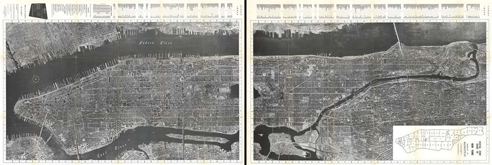
Aerial Photo Map of New York City.
sold
- Digital Map Information
- Suitable for large format printing
- File Size: 340.76 MB
- File Type: ZIP / TIFF
- ICC color profile embedded
- Delivered instantly via download link
This is a c. 1955 National Air Map Company aerial photographic map of the borough of Manhattan in New York City. The map depicts the borough from Battery Park to the Harlem River and from the Hudson River to the East River, Brooklyn, Queens, and the Bronx. Highly detailed, individual buildings are recognizable throughout, including New York City landmarks such as the Metropolitan Museum of Art, the American Museum of Natural History, Rockefeller Center, Radio City Music Hall, Bryant Park and the central New York Public Library Building, and Grand Central Station, all of which are labeled. Several city landmarks are not labeled, including the Empire State Building, which is identifiable by its shadow, and the Guggenheim Museum with its iconic rotunda. Myriad streets are labeled, and the IND, BMT, and IRT subway lines are each illustrated using different notations. Individual docks on both sides of the Hudson River are labeled as well. A street index is situated along the top (or left) border, depending on how one orients the map, which also includes a list of museums and sport centers in the city. (more details)
A French allegorical map commenting on the state of poetry in France at the end of the 17th century.

L'Empire de la Poesie.
sold
- Digital Map Information
- Suitable for large format printing
- File Size: 5.47 MB
- File Type: ZIP / TIFF
- ICC color profile embedded
- Delivered instantly via download link
This is an 1859 reprint of a 1696 Bernard de Fontanelle fantasy map of the Empire of Poetry (L'Empire de la Poesie). The map depicts every region in this allegorical country, which include the Province of High Poetry (Province de la haute Poesie), the Province of Low Poetry (Province de la basse Poesie), the Province of Imitation (Province de l'Imitation) and the Province of False Thoughts Province des Pensees fausses). The capital of this fantastical nation is the Epic Poem (le Poeme epique) situated in High Poetry, while the cities of Burlesque (Le Burlesque) and Comedy (La comedie) are in Low Poetry. The Desert of Good Sense (Desert du bon Sens), which could also be translated as the Desert of Right Meanings, separates High and Low Poetry, while the Mountains of Tragedy form the border between High Poetry and False Thoughts. Two Rivers, Reason and Rhyme, run through the country, although they never converge. The Island of Satire (Isle de la Satire and the Archipelago of Trivia (l'Archipel des Bagatelles) appear in the bay at the bottom of the map. (more details)
Unrecorded first state of a foundational map with extensive manuscript additions relating to American Indian Reservations established in 1867-8.
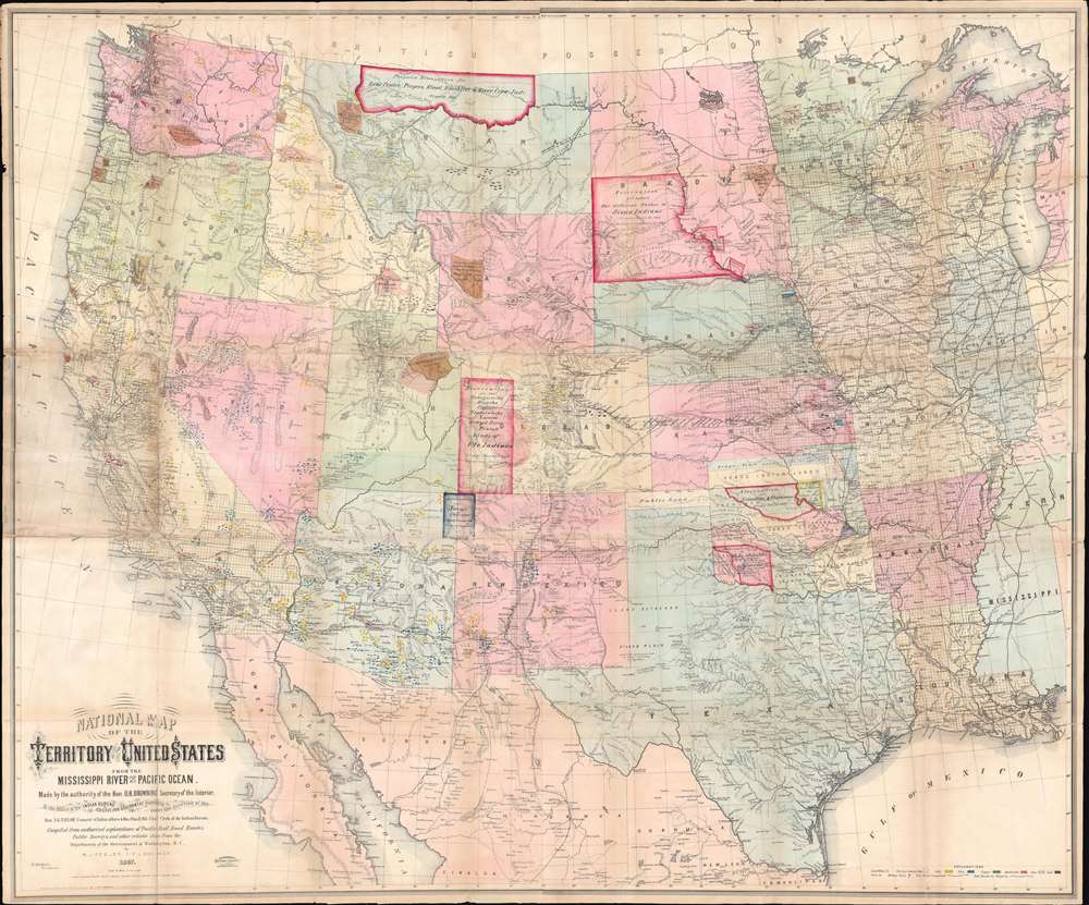
National Map of the Territory of the United States From The Mississippi River To The Pacific Ocean.
sold
- Digital Map Information
- Suitable for large format printing
- Full resolution TIFF file
- ICC color profile embedded
- Delivered instantly via download link
An extraordinary first-edition first-state example of William J. Keeler’s 1867 map of the Trans-Mississippi West - considered the finest post-Civil War railroad era map of the west - with unique manuscript annotations and additions relating to the American Indian Reservation System. This one of a kind historic document was likely the official example retained by the Indian Bureau, and possibly by Keeler himself, to administer and document the development of the American Indian Reservation system through the late 1860s. (more details)
A most stunning manuscript pictorial map by German female artist illustrating the cacao trade.

Geschichte des Kakos.
sold
- Digital Map Information
- Suitable for large format printing
- File Size: 29.43 MB
- File Type: ZIP / TIFF
- ICC color profile embedded
- Delivered instantly via download link
This is an utterly stunning c. 1955 unpublished manuscript pictorial map of the world illustrating the history of the cacao trade. The map was drawn by the female graphic designer Ingeborg Gessner (Inge Klatte) for the Stuttgart chocolate company, Eszet (1857 - 1974). It illustrates the world on a loose Mercator projection stylized to conform to German mid-century aesthetics. The map is rich with vignette images illustrating different phases in the history of cacao and phases of cacao harvesting and production. Color coding distinguishes sources of Cacao in South America, Africa, and Australasia. Vignette images along the bottom border trace the development of the cacao trade from its first Europeans exposure when Hernan Cortez arrived at the Aztec capital of Tenochtitlan, to its introduction to the Spanish court, and indigenous use. Copious annotation in German expounds on cacao throughout. (more details)
Classic single-sheet world map on Mercator's projection... celebrated as one of the supreme examples of the map maker's art. - Shirley
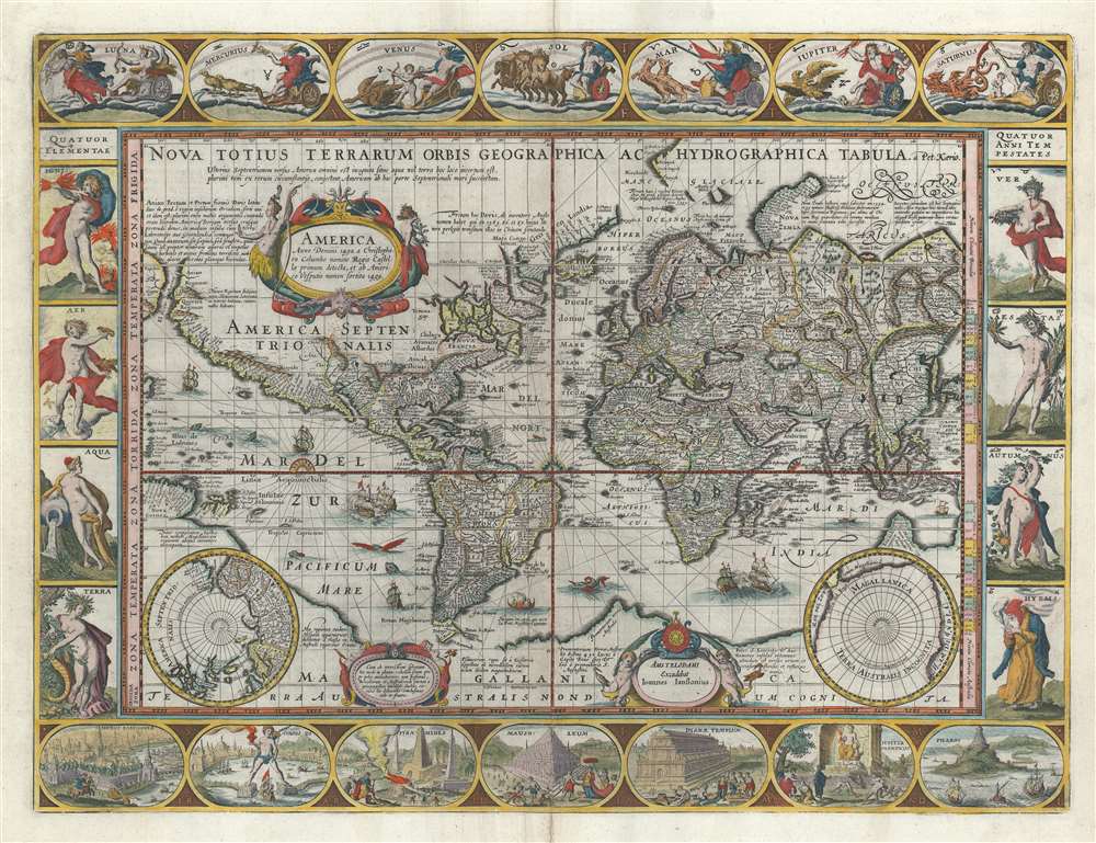
Nova Totius Terrarum Orbis Geographica ac Hydrographica Tabula.
sold
- Digital Map Information
- Suitable for large format printing
- DPI: 600
- File Size: 28.22 MB
- File Type: ZIP / TIFF
- ICC color profile embedded
- Delivered instantly via download link
A striking example of Dutch Golden Age cartography, this is Pieter van de Keere's 1628 carte-á-figures map of the world on the Mercator projection surrounded by allegorical imagery. The cartography embraces many of the common misconceptions of the period, including general confusion regarding the cartography of North America, the polar regions, the interior of Africa, and East Asia. (more details)
Map used to promote investment in John Law's Compagnie d'Occident (Mississippi Bubble) and the first map to show Le Maire's discoveries.

Partie Meridionale De La Riviere De Missisipi, et ses Environs dan L'Amerique Septentrionale.
sold
- Digital Map Information
- Suitable for large format printing
- DPI: 600
- File Size: 23.29 MB
- File Type: ZIP / TIFF
- ICC color profile embedded
- Delivered instantly via download link
A seminal map of the utmost importance and rarity, this is Nicolas de Fer's 1718 map of the Mississippi River Valley drawn to promote the Compagnie d'Occident. Essentially mirroring the coverage of De L'Isle's map of 1703, the map covers from just west of the Rio Grande (Rio del Norte) eastward as far as Charleston, north to include Lake Erie, and south as far as Cuba and the Gulf of Mexico. Per its title, the map is centered on the Mississippi Valley and was intended to illustrate the lush richness of this region. (more details)
Natural resources of Guatemala along with its physical and political geography.
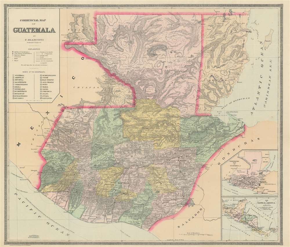
Commercial Map of Guatemala.
sold
- Digital Map Information
- Suitable for large format printing
- File Size: 29.42 MB
- File Type: ZIP / TIFF
- ICC color profile embedded
- Delivered instantly via download link
This is an 1891 F. Bianconi economic map of Guatemala. The map depicts the region from the Pacific Ocean and Mexico to Honduras, El Salvador, and the Caribbean Sea and from Mexico and the Caribbean Sea to El Salvador and the Pacific Ocean. As a commercial map, Guatemala's rich natural resources are extolled from Tikal to the Pacific Ocean. Small print in italics appear throughout the map in both French and Spanish indicate the different products produced, grown, harvested, or raised in a certain region, and these include sarsaparilla, vanilla, mahogany, cedar, pastureland, cotton, wheat, sugarcane, and other grains. 'Forests' is also indicated regularly, creating the presumption that these forests were used to export wood, but not a specific kind of wood, like cedar and mahogany, which are specifically named. (more details)
Scarce map of Shanghai with view of the Bund.

The New Map of Shanghai. /上海最新地圖 / Shànghǎi zuìxīn dìtú.
sold
- Digital Map Information
- Suitable for large format printing
- File Size: 46.64 MB
- File Type: ZIP / TIFF
- ICC color profile embedded
- Delivered instantly via download link
This is a rare and attractive bilingual 1937 map of Shanghai, China. It was made around the start of the Second Sino-Japanese war and World War II. Printed by the Japanese in the 12th year of Hirohito's reign, it depicts central Shanghai including the Chinese Quarter, the French Concession, the English Quarter (along the Bund) etc. Shanghai's cosmopolitan International Settlement is highlighted in Orange (USA), Pink (Great Britain), and Yellow (France). Nineteen important buildings along the Bund are carefully noted and can be referenced via a table to the right of the view. These include the first HSBC Bank, the British Club, the Peace Hotel and the Customs House. There is also a lovely vintage panoramic photo of the Bund along the bottom of the map. Of note, the map includes a large inset in the lower right corner illustrating the development of 'Greater Shanghai'. (more details)
A rare original example of Rummel's panoramic bird's-eye view of Yale Univeristy.

Yale University.
sold
- Digital Map Information
- Suitable for large format printing
- File Size: 28.24 MB
- File Type: ZIP / TIFF
- ICC color profile embedded
- Delivered instantly via download link
A scarce 1906 signed bird's-eye view of Yale University drawn by Richard Rummell and published by W. T. Litting of New York. The view is centered on Osborne Hall (now demolished and replaced with Bingham Hall) with its distinctive chapel-like façade. Chapel Street runs in front of the hall and Temple Street can be seen running northward towards East Rock. Many of the extant buildings of the historic Old Campus, including Connecticut Hall (1752), are easily recognizable. Welch Hall and Lawrance Hall stand alongside College street, across from the New Haven Green which is complete with the three chapels that still stand today: United Church on the Green (Congregational, 1814), Center Church (Congregational, 1812), and Trinity Episcopal Church on the Green (1816). In the distance the heights of East Rock, with its distinctive Soldiers and Sailors Monument, is clearly visible. (more details)
A pictorial map of Jerusalem divided by the pre-1967 border that highlights sites throughout the city printed in Hebrew.

ירושלם העתיקה והחדשה. / Jerusalem Old and New.
sold
- Digital Map Information
- Suitable for large format printing
- File Size: 39.93 MB
- File Type: ZIP / TIFF
- ICC color profile embedded
- Delivered instantly via download link
This is a 1955 Steimatzky pictorial map of Jerusalem in Hebrew. The map depicts the city from the Beth Hakerem neighborhood to the Mount of Olives and the Hill of Evil Counsel and from Mt. Scopus to the Meqor Hayim and Beth Mazmil neighborhoods. Perhaps the most significant aspect of this piece is that it dates from 1955, meaning that the 1949 Armistice Agreement between Israel and Jordan was still in effect (the borders would remain the same until after the 1967 Six-Day War), illustrated here by a rather thick red line. (more details)
An extremely rare 18th century map of England and Wales.
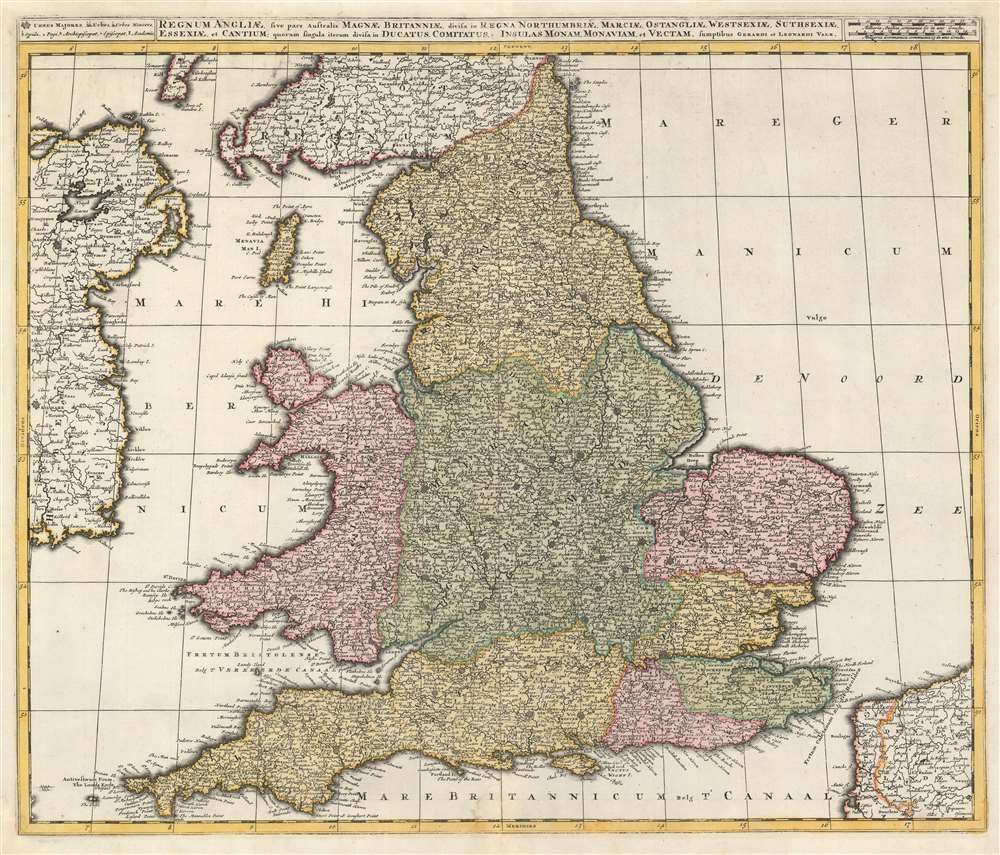
Regnum Angliae, sive pars Australis Magnae Britanniae, divisa in Regna Northumbriae, Marciae, Ostangliae, Westsexiae, Suthsexiae, Essexiae, et Cantium; quorum singula iterum divisa in Ducatus, Comitatus, Insulas Monam, Monaviam, et Vectam.
$1,200.00
Acquire
- Digital Map Information
- Suitable for large format printing
- DPI: 600
- File Size: 31.12 MB
- File Type: ZIP / TIFF
- ICC color profile embedded
- Delivered instantly via download link
This is a 1724 Gerard and Leonard Valk map of England and Wales. The map depicts the region from eastern Ireland to the North Sea and from Scotland to the English Channel, northern France (Pas de Calais and Nord departments), and Belgium. Highly detailed, myriad cities, towns, and villages are labeled throughout the entire region, not just in England and Wales. Some of the identified cities include London, Southampton, Cambridge, Newcastle, and Cardiff (Caerdyf), along with Belfast in Ireland, and Calais and Dunkirk in France. Seven geographical regions within England are shaded different colors to allow for easy differentiation, including East Anglia, Northumbria, Essex, and Sussex. Wales is also differentiated by color. The Isle of Man is depicted in the Irish Sea between England and Ireland. (more details)
Created after the Ottomans conquered Crete, removing it from Venice's overseas empire.
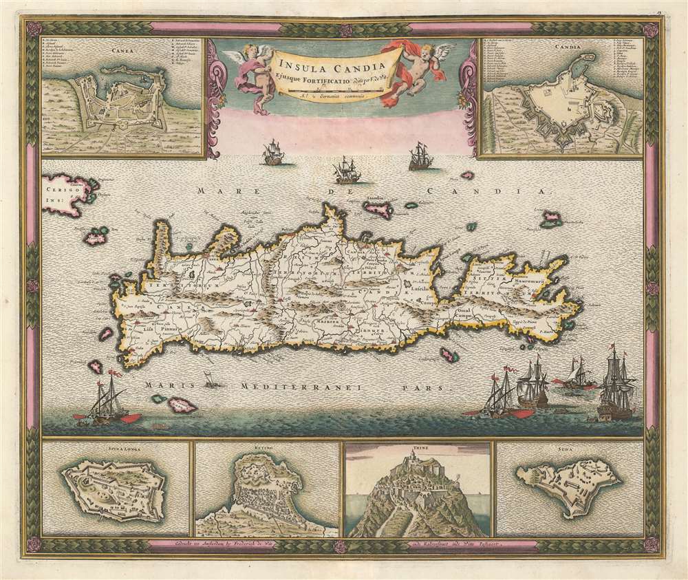
Insula Candia Ejusque Fortificatio.
sold
- Digital Map Information
- Suitable for large format printing
- DPI: 600
- File Size: 29.76 MB
- File Type: ZIP / TIFF
- ICC color profile embedded
- Delivered instantly via download link
This is a c. 1680 Frederik de Wit map of Crete only years after the end of the Cretan War, which is also known as the Fifth Ottoman-Venetian War. Based on a map created by Sébastien Pontault de Beaulieu, the map depicts the entire island after the end of the Siege of Candia, a 24-year long siege of a fortress on Crete. Candia, along with myriad other cities, towns, and villages are labeled all across Crete, and roads, rivers, and mountain ranges are also illustrated. Six inset maps are placed along the borders that focus on Crete's fortresses at Canea, Candia, Spina Longa, Retimo, Thine, and Suda, a natural inclusion since Pontault de Beaulieu is known for his work illustrating Mediterranean fortifications. (more details)
Labels the resort town of Cabo San Lucas.

Baja California.
sold
- Digital Map Information
- Suitable for large format printing
- File Size: 22.75 MB
- File Type: ZIP / TIFF
- ICC color profile embedded
- Delivered instantly via download link
This is a 1946 Segretaria de Agricultura y Fomento map of Baja California. The map depicts the region from the Pacific Ocean to the Mexican state of Sonora and from the United States to San Jose del Cabo and Cabo San Lucas at the southern tip of Baja California. Highly detailed, myriad cities, towns, and villages are labeled throughout Baja California, including Tijuana, Ensenada, La Paz, and Cabo San Lucas. Roads throughout the region are illustrated. Coastal lights and lighthouses are indicated by red circles and semicircles, with the distances they are visible out to sea noted. An inset map of the port of La Paz and its surroundings is situated in the upper right corner and an inset map of Magdalena Bay and its surroundings is included in the lower left quadrant. (more details)
A pictorial map of Singapore highlighting historical, cultural, and commercial sites throughout the city.

Singapore City Character Print.
sold
This is a 1990 Jean-Louis Rheault pictorial map of Singapore. The map depicts the city-state in detail from the Haw Par Villa theme park to Changi Airport and from Johore Bahru to Marina South. Highly detailed, myriad cultural, historical, and commercial locations are identified throughout Singapore. The city's oldest church, Chinese temple and Hindu temple are interspersed among its museums, universities, hospitals, and businesses. These are identified all over the city and include companies identifiable with Singapore, such as the Singapore Broadcasting Corporation, Singapore Telecom, Craft Print, and Tiger Brewery. Others, like Esprit, Swatch, Hard Rock Café, Mercedes-Benz, Shell, Konica, and Bank of America are multinational corporations, and vehicles for the Yellow Pages and DHL are shown throughout the city winding their way through its streets. Hotels appear in every part of the city and are labeled, along with tourist sites like the Singapore Zoo and the Singapore Botanical Garden. Small text blocks are also scattered around the city and provide snippets of the city's history, mostly concerning the Japanese invasion and eventual defeat during World War II. Others reference the Chingay Parade and the fact that, in the early years of settlement in Singapore, tigers would kill approximately 300 people each year. (more details)
Depicts the 'First Meridian', established by French King Louis XIII in 1634.
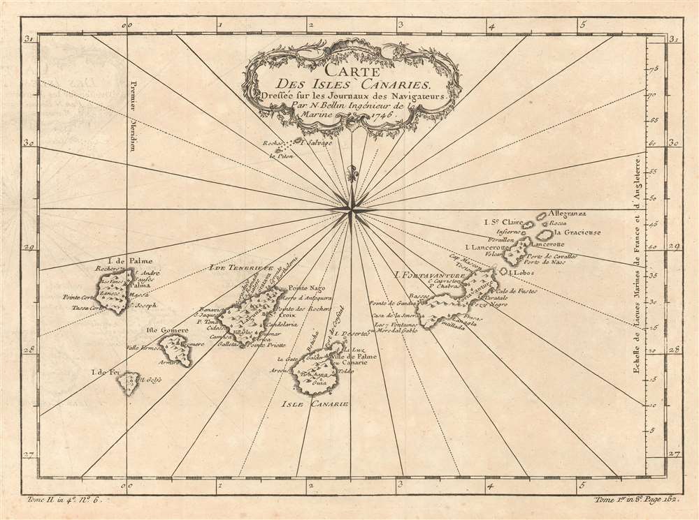
Carte des Isles Canaries.
sold
- Digital Map Information
- Suitable for large format printing
- DPI: 600
- File Size: 4.92 MB
- File Type: ZIP / TIFF
- ICC color profile embedded
- Delivered instantly via download link
This is a 1746 Jacques-Nicolas Bellin map of the Canary Islands. The map depicts the seven Canary Islands, including Tenerife (Isle de Teneriffe), Fuerteventura (I. de Fortaventure), Gran Canaria (I. Canarie), Lanzarote (I. Lancerotte), La Palma (I. de Palme), La Gomera (I. Gomere), and El Hierro (I. de Fer). The Canary Islands are a major tourist destination, welcoming over 12 million tourists every year. Numerous cities are labeled on each of the islands. A meridian, the 'first meridian' is included on the map and runs through El Hierro (I. de Fer). This meridian was created and fixed to El Hierro by declaration of French King Louis XIII in 1634. (more details)
An ephemeral edition of Mitchell's iconic map of California.
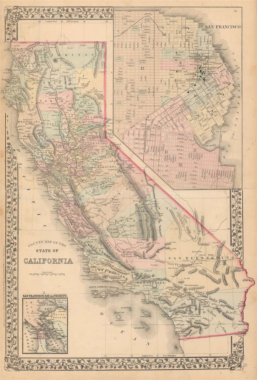
County Map of the State of California.
sold
- Digital Map Information
- Suitable for large format printing
- File Size: 22.52 MB
- File Type: ZIP / TIFF
- ICC color profile embedded
- Delivered instantly via download link
This is an 1871 Samuel Augustus Mitchell, Jr. map of California. The map depicts the region from the Pacific Ocean to Nevada and from Oregon to Baja California. Highly detailed, myriad cities and towns are labeled throughout the state, including Los Angeles, Sacramento, San Francisco, Oakland, Santa Barbara, and San Diego. Counties are identified and shaded different colors to allow for easy differentiation. Railroads are identified by both thick black lines indicating completed routes and dashed black lines for planned routes. Mountains (including the Sierra Nevada), rivers, and lakes are shown. An inset map in the upper right corner depicts the city of San Francisco. Myriad streets are illustrated and labeled, as are a handful of buildings, including the Metropolitan Theater, the opera house, the Wells Fargo office and the International Hotel. City wards are also illustrated and shaded different colors to allow the viewer to differentiate between them. A second smaller inset map in the lower left corner depicts the San Francisco Bay and Vicinity from San Pablo Bay and Vallejo to Point San Mateo. (more details)