
Bilingual German and English map of the region around Mount Everest.

Mahalangur Himal Chomolongma - Mount Everest.
sold
This is the first and most important modern map of the Mount Everest region. This extraordinary map was published in 1957 by the Deutscher Alpenverein (German Alpine Club) and Österreichischer Alpenverein (Austrian Alpine Club) based upon photogrammetric survey work conducted by Erwin Schneider during the 1955 Norman G. Dyrhenfurth Himalaya Expedition. The six-color chromolithograph map depicts the Khumbu, or the south (Nepalese) approach Mount Everest, which appears in the upper right, covering from Tsolatse to Baruntse and from Lingtren to Ama Dablam. The detail throughout, down to stone walls and tiny paths, is an extraordinary representation of the Khumbu's complex terrain. Topography is represented by contours at 20-meter intervals with every 100 meters emphasized. (more details)
The Ptolemaic World.
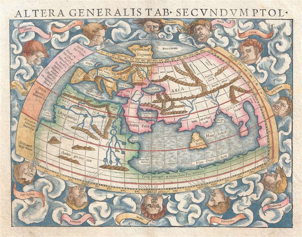
Altera generalis tab. Secundum Ptol.
sold
- Digital Map Information
- Suitable for large format printing
- DPI: 300
- File Size: 4.78 MB
- File Type: ZIP / TIFF
- ICC color profile embedded
- Delivered instantly via download link
An attractive c. 1550 example of Sebastian Munster's map of the world according to Claudius Ptolemy. The map details the world prior to the great age of discovery. As such, it covers only the 'Old World' from the Atlantic (Pillars of Hercules) to Indochina and ... (more details)
An extremely rare edition of Burr's map of Sullivan County, New York - a popular Borscht Belt vacation destination in the late 19th and early 20th centuries.
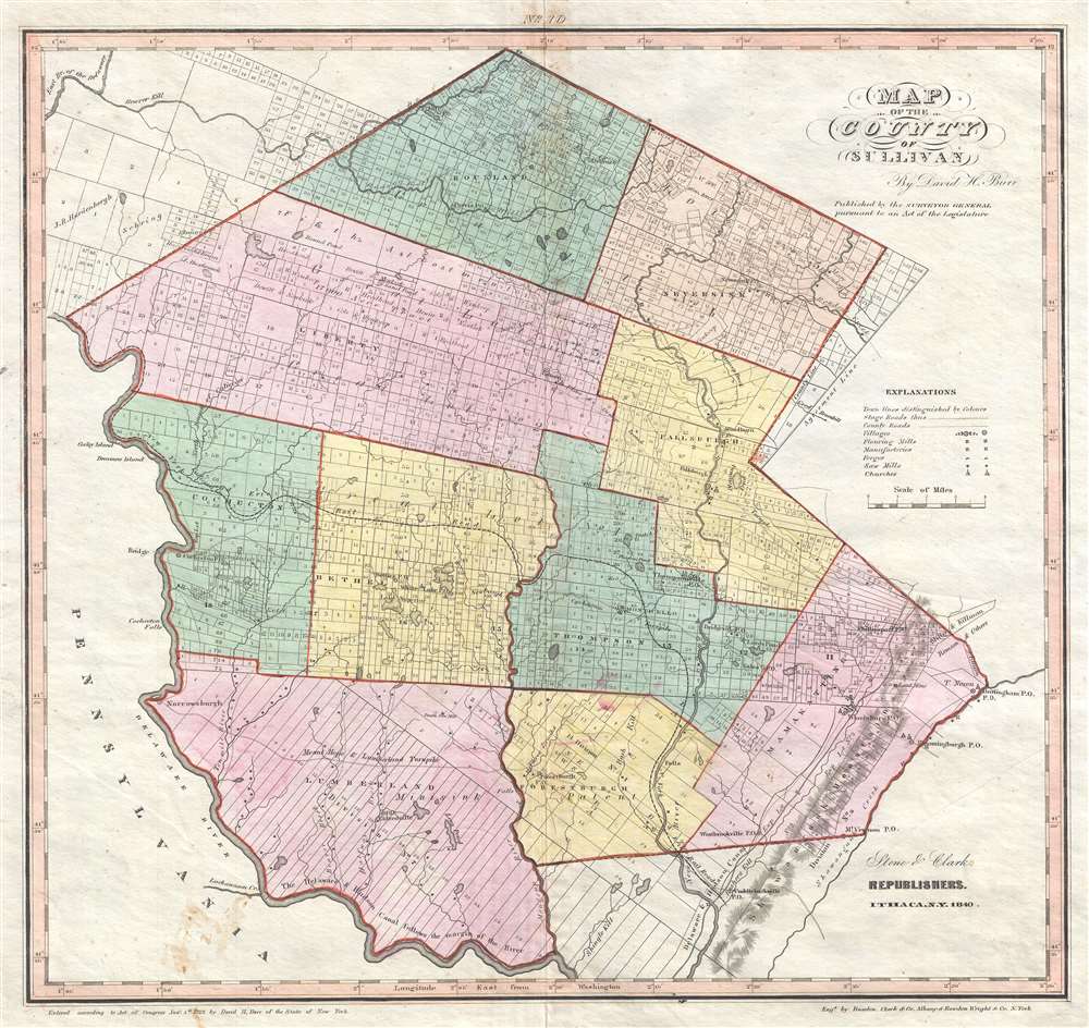
Map of the County of Sullivan.
sold
- Digital Map Information
- Suitable for large format printing
- DPI: 300
- File Size: 7.85 MB
- File Type: ZIP / TIFF
- ICC color profile embedded
- Delivered instantly via download link
This is a rare 1840 David H. Burr map of Sullivan County, New York published by Stone and Clark. Providing a highly detailed illustration of Sullivan County, the map depicts the region from Pennsylvania to the Shawangunk Creek and from the northernmost point in Sullivan County to the Delaware River and the Shawangunk Mountains. Individual towns are illustrated, labeled, and shaded different colors to allow for easy differentiation. Each town is divided into numerous private land claims, some of which are identified by name. Villages, such as Thompsonville, Phillipsport, Fallsburgh, and Neversink are labeled, as is the county seat at Monticello. Mills, forges, manufactories, and churches are also noted, as are county roads and stage roads. The Delaware and Hudson Canal, though not illustrated, is labeled as following 'the margin' of the Delaware River near the bottom border. The Mount Hope and Lumberland Turnpike is also labeled, as are numerous brooks, streams, and ponds. (more details)
Highlights the ephemeral Republic of Texas.
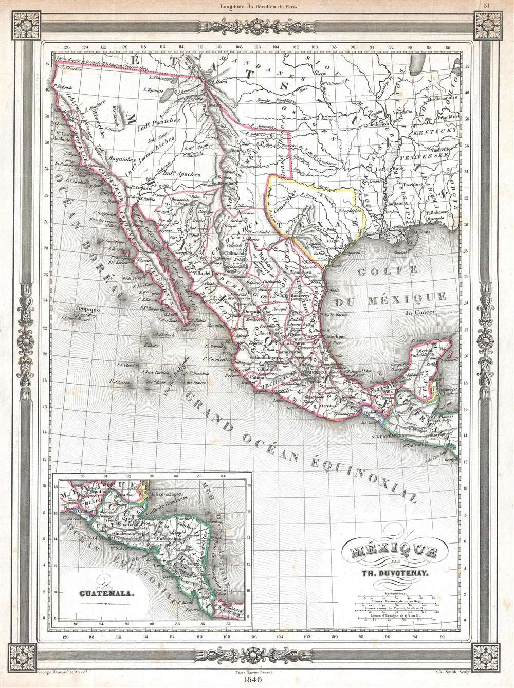
Mexique.
sold
- Digital Map Information
- Suitable for large format printing
- DPI: 300
- File Size: 3.32 MB
- File Type: ZIP / TIFF
- ICC color profile embedded
- Delivered instantly via download link
This is a highly desirable 1846 Thunot Duvotenay map of Mexico. Duvotenay published several different editions of this Mexico map - this being the most desirable due to its depiction of the ephemeral Republic of Texas. Illustrating all of modern day Mexico and ... (more details)
Highly detailed map of Colombo.
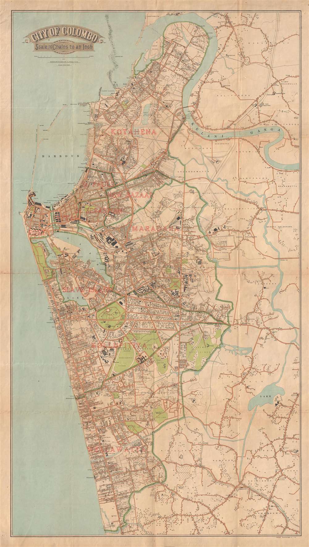
City of Colombo.
sold
- Digital Map Information
- Suitable for large format printing
- File Size: 23.06 MB
- File Type: ZIP / TIFF
- ICC color profile embedded
- Delivered instantly via download link
A scarce 1926 city plan or street map of Colombo, Sri Lanka, issued by A. J. Wickwar, the Surveyor General if Ceylon. The map covers the historic center of Colombo, from the Kelani Ganga River to the Dehiwala Canal. Magnificently produced, the map details al. ... (more details)
A map of the Dutch East Indies near the beginning of the Dutch conquest of the islands.
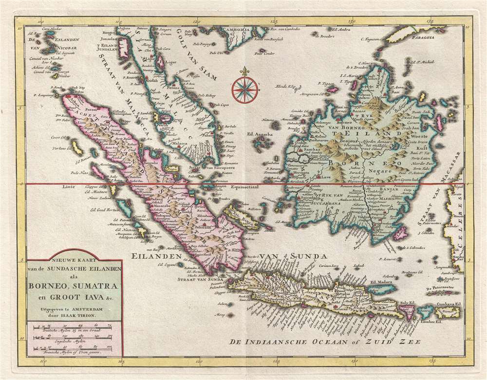
Nieuwe Kaart van de Sundasche Eilanden als Borneo, Sumatra en Groot Jata etc.
sold
- Digital Map Information
- Suitable for large format printing
- DPI: 300
- File Size: 6.01 MB
- File Type: ZIP / TIFF
- ICC color profile embedded
- Delivered instantly via download link
This is a 1754 Isaak Tirion map of the East Indies and the Malay Peninsula, including modern day Singapore. The map depicts the region from the Nicobar Islands to Celebes, Indonesia and from Cambodia to Java. This part of the world quickly became the center of ... (more details)
Illustrates the Old CIty and the Temple Mount in detail.

Jerusalem Old and New.
sold
- Digital Map Information
- Suitable for large format printing
- File Size: 11.61 MB
- File Type: ZIP / TIFF
- ICC color profile embedded
- Delivered instantly via download link
This is a 1942 Steimatzky pictorial map of Jerusalem. The map depicts the city from Karem es Sila to El Tur and the Mount of Olives and from the Hadassa Medical Center, the Hebrew University and Mt. Scopus to Meqor Hayim. Illustrating numerous buildings in ... (more details)
Illustrates both Central Park and Prospect Park the year Prospect Park was founded.

Colton's New York City, Brooklyn, Jersey City, Hoboken, etc.
sold
- Digital Map Information
- Suitable for large format printing
- File Size: 13.24 MB
- File Type: ZIP / TIFF
- ICC color profile embedded
- Delivered instantly via download link
An uncommon example of Colton's 1867 vertical map of New York. This important map, first issued in 1865, marks a significant rethinking of the standard Manhattan map. Previous maps of New York City tended to represent only the lower parts of Manhattan ... (more details)
Ridicules the supporters of free silver for winning only one election in 1898 - for governor of Nebraska.

A Great Joke - Bryan Carried Such a Little Bit.
sold
- Digital Map Information
- Suitable for large format printing
- File Size: 6.44 MB
- File Type: ZIP / TIFF
- ICC color profile embedded
- Delivered instantly via download link
This is an 1899 Victor Gillam political cartoon ridiculing the paltry election returns for supporters of William Jennings Bryan and the free silver movement in the elections of 1899, published in Judge magazine. Here, William Jennings Bryan is dressed in a traditional harlequin outfit (a favorite way of depicting him in Judge) and is being lectured by the Republican boss and Senator Mark Hanna about the losses suffered by candidates who supported free silver in the 1899 elections. Other major figures in the Republican party, including President William McKinley, Vice President Theodore Roosevelt, and Senator Thomas Platt of New York, are illustrated enjoying mocking the fool and his belief in free silver. (more details)
llustrates Nebraska from Iowa to Fremont's Peak.
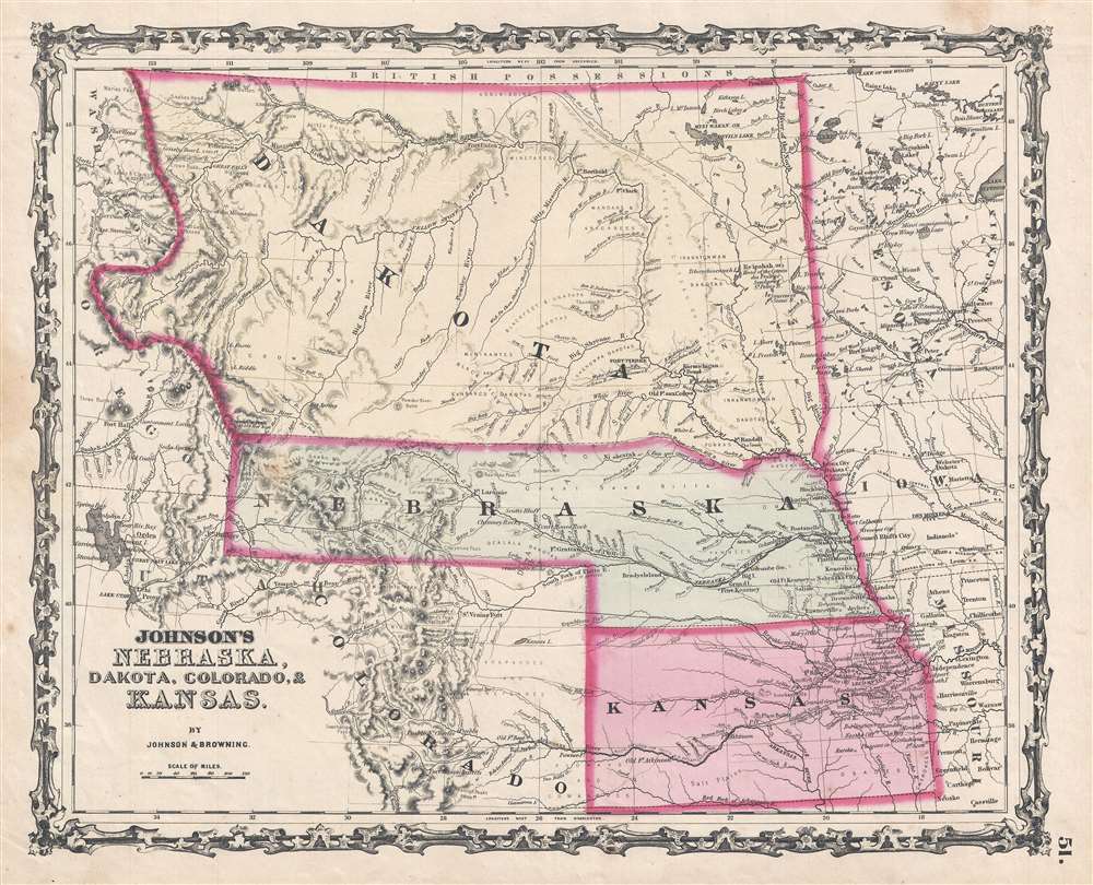
Johnson's Nebraska, Dakota, Colorado, and Kansas.
sold
- Digital Map Information
- Suitable for large format printing
- File Size: 6.28 MB
- File Type: ZIP / TIFF
- ICC color profile embedded
- Delivered instantly via download link
From the 1862 Johnson and Ward edition of the Atlas , this is one of the rarest and most desirable states of Johnson's Dakota, Nebraska and Kansas map. In this example, Nebraska is drawn with a long panhandle, with the state extending from Iowa all the ... (more details)
A charming map of Michigan that traces its many roads and railroads.

A New Map of Michigan with its Canals, Roads and Distances.
sold
- Digital Map Information
- Suitable for large format printing
- DPI: 300
- File Size: 5.09 MB
- File Type: ZIP / TIFF
- ICC color profile embedded
- Delivered instantly via download link
This is an 1854 Thomas Cowperthwait and S. A. Mitchell's map of Michigan. The map depicts the state from Lake Superior to Indiana and Ohio and from Illinois and Lake Michigan to Lake Huron and Canada. Highly detailed, myriad cities and towns are labeled ... (more details)
Maps post-World War II Los Angeles and vicinity mass transit.

Rail and Motor Coach Lines of the Pacific Electric Railway in Southern California.
sold
- Digital Map Information
- Suitable for large format printing
- File Size: 20.76 MB
- File Type: ZIP / TIFF
- ICC color profile embedded
- Delivered instantly via download link
This is a 1946 Pacific Electric Railway Company map of the vicinity of Los Angeles in southern California illustrating the routes of the Pacific Electric Rail and Motor Coach Lines. Founded at the turn of the twentieth century, the map depicts the ... (more details)
A large format postcard bearing one of the last maps published by Jolly Lindgren.

A Hysterical Map of the State of Washington - Which Has Jim Dandy Scenery - As If There Is Any State That Hasn't.
sold
- Digital Map Information
- Suitable for large format printing
- File Size: 1.25 MB
- File Type: ZIP / TIFF
- ICC color profile embedded
- Delivered instantly via download link
This is a c. 1948 Jolly Lindgren postcard sized pictorial map of Washington State. Drawn in Lindgren's trademark style and published as a 'king-size map card' by the Lindgren-Turner Company, the map depicts the state from the Pacific Ocean to Idaho and from Canada to Oregon. Cities and towns throughout the state are labeled, some of which include asides, including 'Seattle - Can You Smell the Sound' and 'Walla Walla (They liked it so well they named it twice, like Sing Sing)'. Wenatchee is marked by an apple, owing to the Apple Blossom Festival that is held that each year, and Davenport is marked by a davenport. Mount Rainier National Park is illustrated, as is the Grand Coulee Dam on the Columbia River. A small legend is situated in the upper left corner, explaining the notations used for towns, trees, lakes, and mountains. (more details)
Extraordinary manuscript map collection of Taiwan and Fujian relating to the 1874 Punitive Expedition and the cartography of Le Gendre.

[Taiwan Manuscript Map Collection relating to 1874 Taiwan Punitive Expedition.]
sold
- Digital Map Information
- Suitable for large format printing
- Full resolution TIFF file
- ICC color profile embedded
- Delivered instantly via download link
An extraordinary collection of nine 1874 manuscript maps detailing Taiwan and part of Fujian province, China. The maps were compiled and drafted by one, Sudo Katsuzō (湏藤 or 湏藤勝三) of Tochigi Prefecture, Japan, on an official or semi-official 1874 mission to Taiwan and thence to mainland China. Most of the maps in this set were compiled between March of and June of 1874 and are related to the 1871 Mundan Incident and the subsequent 1874 Taiwan Punitive Expedition. The Taiwan maps are primarily derived from maps drawn by the American Consul to Qing Taiwan Charles William (Guillaum) Joseph Émile Le Gendre's (August 26, 1830 - September 1, 1899) between 1867 and 1873. Others, particularly those of mainland china and Tamsui, are derived from British Admiralty Hydrographic Charts. In addition to the manuscript maps, the collection also contains its original binder and Sudo's application booklet requesting permission to travel from Taiwan to Fujian and Shanghai. (more details)
A Disney map that was part of the first advertising campaign for sliced bread.

Help Mickey Mouse Beat the Big Bad Wolf - Do Your Part - Buy the Bread with the Mickey Mouse Band and Follow the Race 'Round the World.
sold
- Digital Map Information
- Suitable for large format printing
- File Size: 24.09 MB
- File Type: ZIP / TIFF
- ICC color profile embedded
- Delivered instantly via download link
This is a 1936 Walt Disney Mickey Mouse Globe Trotters Club pictorial map of the world issued as part of the first advertising campaign for sliced bread - that's right 'Sliced Bread'! The map depicts the world from the Americas, across the Atlantic Ocean to Europe, Africa, and Asia, to Australia and the Pacific Ocean. (more details)
Rare map of Nantucket printed in Nantucket!

Historical Map of Nantucket.
sold
- Digital Map Information
- Suitable for large format printing
- File Size: 3.66 MB
- File Type: ZIP / TIFF
- ICC color profile embedded
- Delivered instantly via download link
This attractive 1889 map is a reduced version of Reverend F. C. Ewers important 1869 map of Nantucket. Printed in Nantucket, this variant was issued by the Old Colony Rail Line in various formats from roughly 1872 to 1889. Covers the island of Nantucket in superb detail focusing on transportation and communities. Advertises the 'Old Colony Line' as the 'Shortest, Quickest, Best, and Only Direct Route between Boston or New York and Nantucket and Martha's Vineyard.' Also notes Native American claims to the Island. Features three columns of text breaking down the history of Nantucket from its discovery by Bartholomew Gosnold in 1602 to the laying of the first communications cables between Nantucket and the mainland in 1886. (more details)
Two extremely rare maps of St. Petersburg near the end of the reign of Catherine the Great.
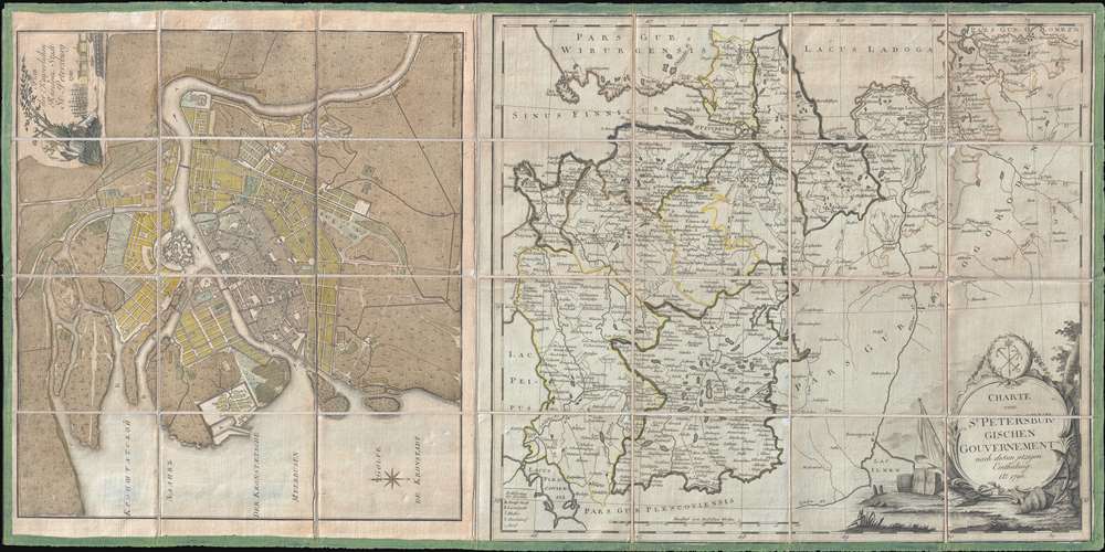
Plan der Kayserlichen Residenz Stadt St. Petersburg. / Charte vom St. Petersburgischen Gouvernement nach dessen jetzigen.
sold
- Digital Map Information
- Suitable for large format printing
- DPI: 300
- File Size: 18.2 MB
- File Type: ZIP / TIFF
- ICC color profile embedded
- Delivered instantly via download link
This is a 1790 Efim Maksimovič Chudjakov city map or plan of St. Petersburg and a 1790 I.D. Schlepper map of the environs of St. Petersburg. The Chudjakov map depicts the city from the Bolshaya Nevka Neva south past the Reka Bol'shaya River and ... (more details)
William Jennings Bryan lost on the free silver ticket in 1896. Eastern Democrats were sickened by the idea of losing again in 1900 with the same candidate and the same platform.

Embalmed. This is What is Making the Eastern Democrats Sick.
sold
- Digital Map Information
- Suitable for large format printing
- File Size: 2.5 MB
- File Type: ZIP / TIFF
- ICC color profile embedded
- Delivered instantly via download link
This is an 1899 Victor Gillam political cartoon ridiculing the resurgence of Free Silver as a part of the political platform of the Democratic party in the election of 1900. The cartoon depicts a rotten package of Dem Free-Silver Brand 'Free-Silver Mule' that is making all the major Eastern Democrats sick. Several democrats are illustrated sprawled on the ground, while David Bennett Hill (August 29, 1843 - October 20, 1910), then the Democratic governor of New York State, holds his nose and reaches for the package. Hill was even a candidate for the vice-presidential nomination in 1900, but lost to Adlai Stevenson I, a former Vice President. The other Democrat that Gillam identifies is Richard Welstead Crocker Sr. (November 24, 1843 - April 22, 1922), who was better known as 'Boss Croker' and was a leader of New York's notorious Tammany Hall. (more details)
American exports of manufactured good surged by nearly ninety percent between 1895-1900.

The Whittler for the World.
sold
- Digital Map Information
- Suitable for large format printing
- File Size: 7.09 MB
- File Type: ZIP / TIFF
- ICC color profile embedded
- Delivered instantly via download link
This is an 1899 Victor Gillam political cartoon highlighting the rise of the United States into a net exporter of manufactured goods. The cartoon depicts Uncle Sam at center, seated on a coal mine on an island, whittling a locomotive. The leaders of the rest of the world, including Italy, Russia, Japan, China, Austria, France, and England, surround him on the shores of both oceans holding bags of money (presumably gold) and clamoring to purchase American built manufactured goods. Orders for engines, bridges, phonographs, and other manufactured goods lie at Uncle Sam's feet, while steel rails, engines, locomotives, steel freight cars, reapers, and typewriters crowd the ground around his feet, waiting to be sent to their eager recipients. (more details)
A rare bilingual panoramic view of Kongo San, one of the leading tourist sites on the Korean Peninsula.

[Bird's Eye View of the World Famous Kongo-San. / 圖瞰鳥大通交山剛金鮮朝勝名界世.
sold
- Digital Map Information
- Suitable for large format printing
- File Size: 11.14 MB
- File Type: ZIP / TIFF
- ICC color profile embedded
- Delivered instantly via download link
This is a 1931 or Showa 6 railway bureau bilingual panoramic view of the Kongo-San region of the Korean peninsula. Today this region is situated in North Korea and is centered around Mount Kumgang ( Geumgangsan ), 'Diamond Mountain'. Geumgangsan ... (more details)